Chalk Fire
Location: 25 miles S of Big Sur, Monterey Co. CA
Specific Location: E of Lucia, Nacimiento-Fergusson Rd., Los Padres NF, Lat 35° 59´ 25″ Lon 121° 25´ 48″ [~15 mi S of Basin/Indian Complex]
Date of Origin: 09/27/2008
Cause: Under investigation
Situation as of 10/30/2008 at 6:00 PM
Personnel: 106
Size: 16,269 acres
Percent contained: 100%
Costs to Date: $23,982,486
Cone Peak Road remains closed until further notice per Monterey District Office.
Interior burning of unburned fuel, creeping and smoldering continues. With predicted rain, crews will not be on the line. Rehab will continue once rains are finished and conditions are suitable.
***************
Situation as of 10/27/2008 at 6:00 PM
Personnel: 166
Size: 16,269 acres
Percent contained: 98%
Costs to Date: $23,734,000
CCIIMT 7 transferred command to a type 3 organization (Mark Nunez ICT3) today, Monday, October 27, 2008 at 0600 hours. All road closures have been removed today at 1200 hours, except for Cone Peak Road which will remain closed until further notice per Monterey District Office. The containment date has been pushed to 10-29-2008 to allow for the transition of command to the type 3 organization and to allow an additional day for rehab work.
Interior burning of unburned fuel, creeping and smoldering.
*************
Situation as of 10/21/2008 at 6:00 PM
Personnel: 654
Size: 15,359 acres
Percent contained: 80%
Costs to Date: $20,000,000
3-4 slopovers / spotfires reported in Div. Y that are being picked up with crews, dozers and aircraft.
*************
Situation as of 10/20/2008 at 6:00 PM
Personnel: 633
Size: 15,359 acres
Percent contained: 80%
Costs to Date: $18,800,000
Continue Firing Operation along the Hermitage Road to the South. A coastal buffer zone of natural vegetation (minimum of 300′) is being left in order to protect Highway 1 from future winter storm activity. Contingency Dozer line at the North edge of Lime Kiln State Park is being completed today. This line will protect the Hermitage and Lime Kiln areas. Preparation for possible burning along this line continues to progress. Approval received for the construction of dozer line from apex medi-vac helispot north to Gamboa ridge.
*************
Situation as of 10/17/2008 at 3:00 PM
Personnel: 338
Size: 12,010 acres
Percent contained: 93%
Costs to Date: $17,023,259 (no explanation for reduction in costs)
Evacuation Warning for Lime Kiln and Hermitage
Fire flaring up again. CCIIMT7 team ordered for incident. In brief on 10.17.08 at 1800 hours with transition scheduled for 10.18.08 at 0600.
*************
Situation as of 10/15/2008 at 5:00 PM
Personnel: 215
Size: 11,310 acres
Percent contained: 97%
Costs to Date: $17,203,000
Continued creeping fire activity in the Hare Creek area. The remainder of the fire perimeter continues to smolder with isolated hot spots. Crews will complete contingency line W of Hare Creek. Continue to mop up and patrol.
*************
Situation as of 10/13/2008 at 4:00 PM
Personnel: 144
Size: 11,210 acres
Percent contained: 97%
Costs to Date: $16,253,470
Increased fire activity in the Hare Creek area. Fire behavior in the remainder of the fire perimeter continues to be smoldering with isolated hot spots.
*************
Situation as of 10/12/2008 at 4:00 PM
Personnel: 144
Size: 11,189 acres
Percent contained: 97%
Costs to Date: $15,341,000
Smoldering with isolated hot spots.
*************
Situation as of 10/11/2008 at 5:00 PM
Personnel: 145
Size: 11,189 acres
Percent contained: 97%
Costs to Date: $15,341,000
Type 3 organization (Kremke) assumed command at 0600.
The remainder of the uncontained perimeter is inaccessible terrain (100% slope) and is not safe for firefighters to work. The area was flown today with the use of IR to monitor activity. There had been no movement reported in this area for several days.
*************
Situation as of 10/10/2008 at 6:00 PM
Personnel: 696
Size: 11,189 acres
Percent contained: 97%
Costs to Date: $14,756,000
Command of this incident will transition from Central Coast Team 7 (Smith) to a Type 3 Organization (Kremke) Saturday, 10/11/2008, at 0600. Daily IR flights are being utilized to identify remaining hot spots. Smoldering with isolated hot spots on the interior. Demob.
*************
Situation as of 10/08/2008 at 6:00 PM
Personnel: 1,048
Size: 11,189 acres
Percent contained: 69%
Costs to Date: $13,293,000
The evacuation watch has been lifted by Monterey County Sheriff Dept.
Weather conditions transitioning back to warmer and dryer over the fire area. Remarks: We will begin utilizing a 24 hour daily plan today due to minimal night time staffing. Current efforts focus on containment of northwest and southeast Corners. Continued mop-up and rehab where needed. Patrol of accessible fire area overnight. Remainder of open fire line is not safely accessible at night due to terrain.
*************
Situation as of 10/07/2008 at 6:00 PM
Personnel: 1,322
Size: 11,189 acres
Percent contained: 69%
Costs to Date: $11,979,000
Structures Threatened: 9 residences , 15 outbuildings
Crews began fire suppression rehab in addition to continued mop-up. Weather conditions transitioning back to warmer dryer conditions over the fire area. Constructing direct fire line on large fingers continues in extremely steep rugged terrain making overall containment a slow process. Smoldering with some down dead and snags openly burning.
Unified command will terminate at 0600 hrs. on 10-8-08.
*************
Situation as of 10/06/2008 at 6:00 PM
Personnel: 1,327
Size: 11,189 acres
Percent contained: 67%
Costs to Date: $10,843,000
Structures Threatened: 9 residences , 15 outbuildings
The reduction in the “fire line to build” figure reflect a change in fire suppression tactics. Earlier on the fire, crews were having to construct indirect line because of active burning conditions. As a result of the rain on 10/4 and its affect on fuel conditions, firefighters are now able to do more direct line construction which more closely follows the fire’s perimeter.
Crews continue the arduous task of seeking opportunities for direct line construction. Structure protection remains a priority. [direct quote; apparently the fire crews are not used to the arduous task of building direct fire lines and so the job requires superlatives in the 209 report. - Ed]
*************
Situation as of 10/05/2008 at 6:00 PM
Personnel: 1,228
Size: 12,168 acres reported (no update)
Percent contained: 37%
Costs to Date: $9,697,000
Structures Threatened: 9 residences , 15 outbuildings
Evacuation Warning has been lifted. Evacuation Watch orders are still in place by Monterey County Sheriff Dept.
Current efforts focus on containment of northwest corner and holding southwest flank.
*************
Situation as of 10/04/2008 at 6:00 PM
Personnel: 1,319
Size: 12,168 acres
Percent contained: 30%
Costs to Date: $8,430,000
Structures Threatened: 19 residences , 30 outbuildings
Fire increased in size ~1,500 acres today. The fire burned through a track of residences on the south flank. Due to successful suppression efforts no homes were destroyed by fire. Minimal damage was reported.
Traffic flow on Hwy 1 was affected intermittently today due to fire equipment activity.
Current efforts focus on containment of northwest corner and holding southwest flank.
*************
Situation as of 10/03/2008 at 6:00 PM
Personnel: 1,494
Size: 10,650 acres
Percent contained: 20%
Costs to Date: $7,282,909
Structures Threatened: 19 residences , 30 outbuildings
Fire increased in size ~600 acres today. The fire burned through a track of residences on the south flank. Due to successful suppression efforts no homes were destroyed by fire. Minimal damage was reported.
Traffic flow on Hwy 1 was affected intermittently today due to fire equipment activity.
Majority of containment effort continues on the west flank to protect structures and to minimize impact to Hwy 1. Forecasted weather (approaching cold front, strong winds) may hamper suppression efforts for next 12 hours.
*************
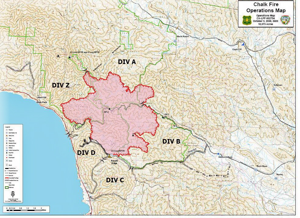
Situation as of 10/03/2008 at 7:00 AM
Personnel: 1,489
Size: 10,073 acres
Percent contained: 20%
Costs to Date: $5,800,000
Structures Threatened: 32 residences , 45 outbuildings
Fire doubled in size over the last 48 hours, or more accurate reporting is taking place. A public meeting was held with Big Sur Coast residence today to discuss fire conditions.
Measurable rain predicted in fire area Friday/Saturday. Good thing, because fire suppression efforts are nil or totally ineffective, or both.
Map below is 2 hours old. Click on map for larger image.
***************
Situation as of 10/02/2008 at 7:00 AM
Personnel: 1,473
Size: 7,079 acres
Percent contained: 20%
Costs to Date: not updated
Structures Threatened: 18 residences , 18 outbuildings
Moderate rate of spread reported. Considering the fire is expanding 2,000 acres a day, that remark is relative and subjective. Acreage estimate beginning to approach reality.
***************
Situation as of 10/01/2008 at 6:00 PM
Personnel: 1,410
Size: 5,050 acres
Percent contained: 13%
Costs to Date: $3,100,000
Structures Threatened: 18 residences , 18 outbuildings
Significant cost increase due to addition of Air Ops cost over past four days. Threat to commercial buildings has been removed due to successful protection efforts as fire moved through. [Unclear what commercial buildings this refers to. It could be the USFS facility on Nacimiento-Fergusson Rd. near the Coast Ridge Trail.]
Fire is much larger than reported. MODIS satellite indicates hot spots in Hare Canyon near the coast at Lime Kiln State Park, S of Chalk Peak, and E to USFS/Hunter Liggett boundary. The area indicated on the MODIS maps seems to exceed 8,000 acres.
***************
Situation as of 09/30/2008 at 6:00 PM
Personnel: 1,326
Size: 3,453 acres
Percent contained: 8%
Costs to Date: $1,800,000
11 people advised to evacuate in Dempsey Flat area and Beiar Property.
Occasional slope runs, moderate rate of spread, rollout pushing fire down slope. Large smoke plumes.
This incident will be in unified command with Fort Hunter Liggett at 0600 10/01/08.
***************
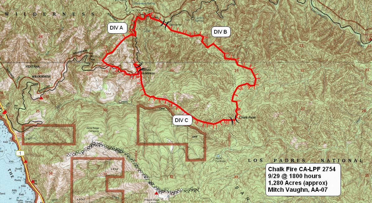
Situation as of 09/29/2008 at 6:00 PM
Personnel: 830
Size: 1,708 acres
Percent contained: 5%
Acreage is underestimated. According to MODIS satellite images the fire extends from Lime Kiln State park S to Chalk Peak and is ~ 4 mi long by 3 mi wide. That would put the fire at over 7,500 acres. More updates/corrections soon.
Update Tuesday, 09/30/2008, at 8 AM
Personnel 1,100+. 12 residences threatened and evacuated. Fire near homes, but no reports of structures lost as yet. MODIS satellite images may be wrong, because acreage still being reported at less than 2,000 acres. Map below is 12 hours old. Click on map for larger image.
Roblar Fire
Location: Camp Pendelton near Roblar Canyon, Sand Diego Co., CA
Specific Location: Lat 33° 40´ 45″ Lon 117° 36´ 50″
Date of Origin: 09/25/2008
Cause: Unknown
Situation as of 09/29/2008
Personnel: not reported
Size: 400 acres
Percent contained: 100%
***************
Situation as of 09/25/2008
Personnel: 72
Size: 400 acres
Percent contained: 40%
Continuous short range spotting, fire whirls. East side burnout halted fire spread.
Wizard Fire
Location: 18 Miles NW of Sisters, Deschutes Co., OR
Specific Location: Wizard Falls, 1 mile N of Canyon Creek, 3 miles N of Camp Sherman, both sides Metolius River, Deschutes NF, Lat 44° 30´ 49″ Lon 121° 37´ 21″
Date of Origin: 09/25/2008
Cause: Human, escaped prescribed burn
Situation as of 10/04/2008 at 3:00 PM
Personnel: 162
Size: 1,840 acres
Percent contained: 100%
Costs to Date: $3,849,914
Light rain over fire area. Mop up, patrol and rehab. continued on all Divisions. Evacuation plan has been lifted. Transfer of command from IMT2 Paul to IMT3 Mitchel October 5 at 0600.
***************
Situation as of 10/02/2008 at 3:00 PM
Personnel: 442
Size: 1,840 acres
Percent contained: 75%
Costs to Date: $3,294,627
Area closure reduced. Successful burnout last operational period. Isolated showers over fire area.
***************
Situation as of 10/01/2008 at 5:00 PM
Personnel: 562
Size: 1,500 acres
Percent contained: 50%
Costs to Date: $2,774,114
Burnout continues in Div Z as dictated by fire spread. Burnout operations to the 14 Road should be complete by end of night shift. Acreage increase (~400 acs) due to burnout operations.
***************
Situation as of 09/30/2008 at 6:00 PM
Personnel: 533
Size: 1,190 acres
Percent contained: 40%
Costs to Date: $2,224,210
Firing operations continue from Green Ridge Lookout down ridge to Road 14. Burnout timing critical with fire weather and the fire spread towards the control line. Firing will occur later to continue to bring the fire edge off steeper slopes. Fire effects being considered closely within the Green Ridge RNA. Helicopter bucket support working to slow fire movement as well as prevent stand replacement fire intensities.
***************
Situation as of 09/29/2008 at 6:00 PM
Personnel: 451
Size: 1,150 acres
Percent contained: 35%
Costs to Date: $1,500,000
Local public interest is very high. [No doubt. Camp Sherman is about the only patch of the Metolius watershed that hasn't been incinerated in the last 10 years. -Ed]
Fire grew ~650 acres in the last few days. Some of that is due to backburning. Fire still spreading N. Originally supposed to be a 30 acre prescribed fire, now 1,150 acres burned and $1.5 million spent.
***************
Situation as of 09/28/2008 at 7:00 PM
Personnel: 449
Size: 500 acres
Percent contained: 10%
Costs to Date: $1,025,000
Transfer of command to the ORCA type 2 IMT will occur at 0600 on 9/29.
***************
Situation as of 09/27/2008 at 8:20 PM
Personnel: 424
Size: 500 acres
Percent contained: 10%
Costs to Date: $400,000
The ORCA Type 2 team has been ordered, inbriefing scheduled for 1000 on 9/28.
***************
Situation as of 09/26/2008 at 7:15 PM
Personnel: 257
Size: 300 acres
Percent contained: 10%
Area Closure was established today, Allen Springs, Pioneer Ford and Lower Bridge campgrounds are closed.
Active fire behavior with spotting up to 1 mile.
***************
Situation as of 09/25/2008 at 8:00 PM
Personnel: 115
Size: 200 acres
Percent contained: 5%
Fire mostly E of Rd 14 and the Metolius River. Isolated crown runs with short range spotting. Fire moving uphill, downwind, to the E.
No report on structures at Wizard Falls Fish Hatchery.
Big Cove Fire
Location: 5 miles W of Willowdale, Wasco Co. OR
Specific Location: N of South Junction, S. Junction Rd., E side Deschutes River, Lat 44° 49´ 31″ Lon 120° 57´ 49″ [coordinates corrected based on Google Fire map].
Date of Origin: 09/20/2008
Cause: lightning
Situation as of 09/25/2008 at 7:00 PM
Personnel: 7
Size: 4,779 acres
Percent contained: 100%
Fire was downsized in acreage, due to gps mapping.
***************
Situation as of 09/24/2008 at 5:00 PM
Personnel: 11
Size: 6,000 acres
Percent contained: 40%
Trout Creek Campground threatened. South Junction Campground burned over with no structures involved. Fire started on private, unprotected land and then moved onto BLM
protection on 9/23 around 1700 hrs.
First official report on 09/25/2008.
Horseshoe Fire
Location: 25 Miles E of LaPine, Lake Co., OR
Specific Location: Horseshoe Butte, Deschutes NF, Lat 43° 33´ 8″ Lon 120° 58´ 13″
Date of Origin: 09/24/2008
Cause: under investigation
Situation as of 09/27/2008 at 4:30 PM
Personnel: 15
Size: 415 acres
Percent contained: 100%
Costs to Date: not updated
Fire declared contained. Last report until we get a Control date and Fire Out date.
***************
Situation as of 09/26/2008 at 6:00 PM
Personnel: 15
Size: 415 acres
Percent contained: 75%
Costs to Date: not updated
Creeping and smoldering
***************
Situation as of 09/25/2008 at 7:30 PM
Personnel: 22
Size: 415 acres
Percent contained: 60%
Costs to Date: $50,000
Only interior islands burning, no spots outside the line.
***************
Situation as of 09/24/2008 at 8:00 PM
Personnel: 22
Size: 414 acres
Percent contained: 20%
Kitson Fire
Location: 4 miles SE of Oakridge, Lane Co. OR
Specific Location: Kitson Ridge near Hills Creek Reservoir, Lat 43° 40´ 42″ Lon 122° 20´ 50″
Date of Origin: 09/24/2008
Cause: under investigation
Situation as of 10/02/2008 at 8:00 PM
Personnel: 303
Size: 808 acres
Percent contained: 100%
Costs to Date: $3,953,981
Reached containment. Central Oregon Incident Management Team will transfer command of this incident to a Type 3 management team (Poet) tomorrow, Friday, October 3, 2008 at 0630.
***************
Situation as of 10/01/2008 at 8:00 PM
Personnel: 535
Size: 808 acres
Percent contained: 95%
Costs to Date: $3,608,229
Containment expected today. Demob planned.
***************
Situation as of 09/30/2008 at 8:00 PM
Personnel: 774
Size: 808 acres
Percent contained: 85%
Costs to Date: $3,188,322
Div. A, B, and C mopped up 300+ feet. Smoldering and creeping with heavy fuels continuing to burn out in the interior. Winds may pick up late evening, 15 mph with gusts to 22 max. Rain late Friday.
***************
Situation as of 09/29/2008 at 8:00 PM
Personnel: 750
Size: 808 acres
Percent contained: 60%
Costs to Date: $2,663,203
Acreage change is due to more accurate mapping. East winds did not surface(stayed high). Haines 5 on Tuesday. Still hot and dry. Heavy fuels continue to burn out. Areas of low intensity surface fire with intense interior heat.
***************
Situation as of 09/28/2008 at 8:00 PM
Personnel: 713
Size: 1,000 acres
Percent contained: 40%
Costs to Date: $2,001,510
3/4 acre slopover on Div. Z and spot fire on Div. C. More active fire late today. Creeping, smoldering in closed canopy. Single tree torching in reprod and short range spotting. Low intensity surface fire.
East winds will persist through late Monday. Red Flag Warning 0300 to 2300. Haines 6.
***************
Situation as of 09/27/2008 at 8:30 PM
Personnel: 616
Size: 1,000 acres
Percent contained: 35%
Costs to Date: $1,383,530
Line completed (but not burned out yet). Will be completed tomorrow (9/28). Heavy fuels continue to burn. Burnouts on Div. Z and C.
East winds predicted for tomorrow and Monday. Peaking AM Monday. Predicted Haines 5 tomorrow and Haines 6 for Monday.
***************
Situation as of 09/26/2008 at 8:00 PM
Personnel: 516
Size: 1,000 acres
Percent contained: 25%
Costs to Date: $800,691
A public closure order has been issued for the area.
Held existing line with the help of Type I helicopters. Line nearly completed, 1/4 miles of line remaining to be constructed. Started plumbing some sections of Div A & B. An unoccupied vehicle was destroyed by a fire-weakend green trees. No one was near the rig at the time of incident.
East winds projected for Sunday.
***************
Situation as of 09/25/2008 at 7:00 PM
Personnel: not reported, 100+
Size: 1,000 acres
Percent contained: 45%
Central Oregon Type 2 IMT (Rapp) will be taking over the fire at 0600 hours, 09/26/2008.
Fire Behavior: Flame Lengths: 2-3 feet. ROS: 1-2 chains per hour. Fire behavior was minimal today due to elevated fuel moistures on the fire.
***************
Situation as of 09/24/2008 at 2:45 PM
Personnel: not reported
Size: 250 acres
Percent contained: 0%
Hidden Fire
Location: 12 miles NNE of Three Rivers, Tulare Co. CA
Specific Location: Kings Canyon NP, Lat 36° 36´ 16″ Lon 118° 51´ 30″
Date of Origin: 09/10/2008
Cause: lightning
Situation as of 09/30/2008 at 6:00 PM
Personnel: 124
Size: 3,668 acres
Percent contained: 100%
Costs to Date: $8,913,311
Ground resources continued mop-up and patrol of the containment lines. Fire suppression rehabilitation of the control lines has begun and will continue for the next 6 to 7 days. This will be the final ICS 209 issued for this fire.
***************
Situation as of 09/29/2008 at 6:00 PM
Personnel: 166
Size: 3,660 acres
Percent contained: 98%
Costs to Date: $8,720,000
Cloud cover, higher RH’s and rain in the fire area significantly slowed the burning of the interior fuels. Ground crews monitored the burning of the interior fire area and continued to mop up and patrol the containment lines.
***************
Situation as of 09/28/2008 at 6:00 PM
Personnel: 189
Size: 3,637 acres
Percent contained: 96%
Costs to Date: $8,526,000
The current infrared scan indicates that the actual burned acres are at 3,637 acres. Once the interior of the fire area fully burns out the remaining fuels inside the lines, the final acreage should come close to 3,688 acres.
Ground crews with assistance from air resources monitored the burning of the interior fire area and continued to mop up and patrol the containment lines.
***************
Situation as of 09/27/2008 at 6:00 PM
Personnel: 175
Size: 3,546 acres
Percent contained: 95%
Costs to Date: $8,387,000
The current infrared scan indicates that the actual burned acres are at 3546 acres. Once the interior of the fire area fully burns out the remaining fuels inside the lines, the final acreage should come close to 3,688 acres.
Ground crews with assistance from air resources monitored the burning of the interior fire area and continued to mop up and patrol the containment lines.
***************
Situation as of 09/25/2008 at 6:00 PM
Personnel: 145
Size: 2,954 acres
Percent contained: 92%
Costs to Date: $7,973,479
Firing operations continued today on the interior of the fire perimeter to further strengthen the fire line. The current infrared scan indicates that the actual burned acres are at 2954 acres. Once the interior of the fire area fully burns out the remaining fuels inside the lines, the final acreage should come close to 3683 acres.
***************
Situation as of 09/24/2008 at 6:00 PM
Personnel: 491
Size: 3,693 acres
Percent contained: 90%
Costs to Date: $7,221,464
Transition from Southern California Interagency Team 1 to a Type 3 organization will occur at 1800 hrs. Hand firing operations will continue along indirect lines to deepen the perimeter. Smoky conditions in San Joaquin Valley continue to impact human health and safety.
***************
Situation as of 09/23/2008 at 6:00 PM
Personnel: 538
Size: 3,693 acres
Percent contained: 85%
Costs to Date: $7,077,021
Fire size increase due to completion of burning operations. This operation has placed a black line around the fire and all acres within this boundary are now being counted.
Hand firing operations will continue along indirect lines. Aerial ignition will be used to strengthen control lines along the north and east flanks in the upper Yucca and Cascade Creek drainage’s.
The purpose of the hand and aerial ignition is to napalm the National Park like it was Viet Nam. Scorched earth wasteland is the goal.
***************
Situation as of 09/21/2008 at 6:00 PM
Personnel: 781
Size: 1,536 acres
Percent contained: 48%
Costs to Date: $6,189,568
This fire is being managed using the Wildland Fire Decision Support System (WFDSS). Crews continue to spike out on the fireline for three day rotations. There is a total of 10.33 miles of completed line and 4.2 miles of completed line are left to be burned out.
Hand firing operations will continue along indirect lines. Aerial ignition will be used to strengthen control lines along the north and east flanks in the upper Yucca and Cascade Creek drainage’s.
The purpose of the hand and aerial ignition is to “reintroduce natural fire” via the use of petroleum byproducts and deliberate human fire lighting in the National Park.
***************
Situation as of 09/19/2008 at 6:00 PM
Personnel: 739
Size: 1,296 acres
Percent contained: 37%
Costs to Date: $4,100,000
Structures Threatened: NONE Structures Destroyed: NONE
Fire burned actively to the west and south. Fire made short moderate intensity runs through the thick ground fuels. Fire was very active in the Yucca Ridge area and is well established in this drainage.
This fire is being managed using the Wildfire Decision Support System (WFDSS). Crews will be spiked out on the fireline for three day rotations supported by helicopters. Crews began to burnout control lines along Yucca Ridge and Pine Ridge checking the fires spread to the W and N.
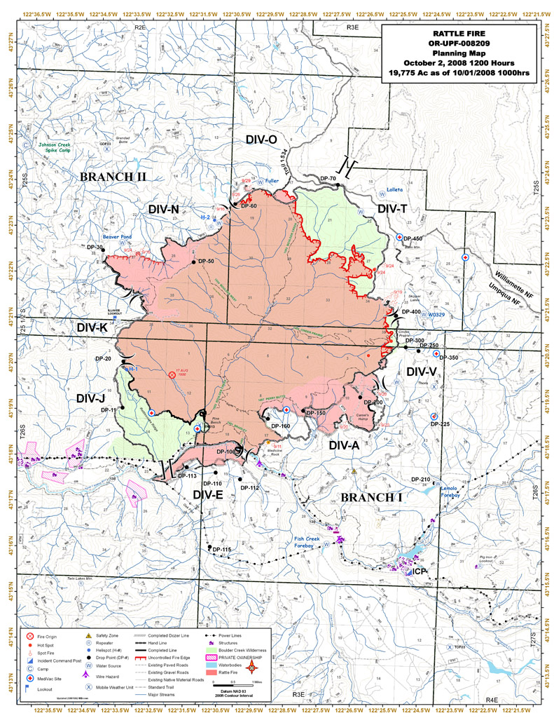
North Fork Complex/Rattle Fire (Repost)
Location: 10 miles NE of Steamboat, Lane Co., OR
Specific Location: S Fork Cedar Creek, trib to Steamboat Creek, trib to N Umpqua River, Umpqua NF, Lat 43° 27′ 21″ Lon 122° 38′ 25″
Date of Origin: 08/13/2008
Cause: lightning
Situation as of 10/08/2008 at 4:00 PM
Personnel: 26
Size: 20,226 acres (Rattle Fire 19,775 acs; North Fork Fire 451 acs and 100% contained)
Percent contained: 90%
Costs to Date: ~$30 million ($21,057,784 reported)
Transfer fire back to local unit at 1800 and close out with forest.
***************
Situation as of 10/06/2008 at 5:00 PM
Personnel: 112
Size: 20,226 acres (Rattle Fire 19,775 acs; North Fork Fire 451 acs and 100% contained)
Percent contained: 90%
Costs to Date: ~$30 million ($20,955,000 reported)
Continued demob of resources and equipment. Stump holes and snags smoldering.
***************
Situation as of 10/05/2008 at 4:30 PM
Personnel: 131
Size: 20,226 acres (Rattle Fire 19,775 acs; North Fork Fire 451 acs and 100% contained)
Percent contained: 90%
Costs to Date: ~$29.8 million ($20,760,000 reported)
Extensive demob continues. Chipping and road work.
***************
Situation as of 10/04/2008 at 3:00 PM
Personnel: 170
Size: 20,226 acres (Rattle Fire 19,775 acs; North Fork Fire 451 acs and 100% contained)
Percent contained: 90%
Costs to Date: ~$29.6 million ($20,580,000 reported)
Approx 2″ of rain has been received over most of the fire area from this frontal passage. Extensive rehab on line and backhaul or equipment.
Boulder Creek Wilderness 90% burned. Click map for larger image.
***************
Situation as of 10/02/2008 at 6:00 PM
Personnel: 310
Size: 20,226 acres (Rattle Fire 19,775 acs; North Fork Fire 451 acs and 100% contained)
Percent contained: 70%
Costs to Date: ~$29.1 million ($20,100,000 reported)
Fire size increased by ~110 acres yesterday. A road closure order was put into effect for Forest Road 5851 on the Willamette National Forest.
Rain on the fire allowed crews to advance containment lines around the slop-over to the N. Fire behavior was moderated due to the weather. Significant rain is forecasted for the area over the next few days and fire behavior is expected to decrease.
***************
Situation as of 10/01/2008 at 6:00 PM
Personnel: 340
Size: 20,113 acres (Rattle Fire 19,662 acs; North Fork Fire 451 acs and 100% contained)
Percent contained: 65%
Costs to Date: ~$28.8 million ($19,760,000 reported)
Fire size increased by ~660 acres yesterday. Indirect line is being built north of the Boulder Creek Wilderness boundary along Bulldog Trail 1534 and Road 5851. Plans have been developed to burn out this area if conditions warrent. Additional resources have arrived to help with this effort.
The fire continues to move northward within and beyond the Boulder Creek Wilderness Area. Multiple spots across the north contingency line. Fire now in the Willamette National Forest.
***************
Situation as of 09/30/2008 at 6:00 PM
Personnel: 301
Size: 19,457 acres (Rattle Fire 19,006 acs; North Fork Fire 451 acs and 100% contained)
Percent contained: 65%
Costs to Date: ~$28.5 million ($19,450,000 reported)
Fire size increased by ~170 acres yesterday. Fire intensity has increased and the fire has moved steadily to the north and east. It has crossed the 3810 road at several locations. [The 3810 Rd. is N of the wilderness boundary at the ridgetop separating the Umpqua and Willamette watersheds. - Ed].
The fire continues to move northward within and beyond the Boulder Creek Wilderness Area. The spot across the 3810 road yesterday was 13 acres. Today there were multiple spots across the north contingency line, the largest estimated at 50 acres. These spots are near the boundary of the Willamette National Forest.
***************
Situation as of 09/29/2008 at 6:00 PM
Personnel: 305
Size: 19,289 acres (Rattle Fire 18,838 acs; North Fork Fire 451 acs and 100% contained)
Percent contained: 65%
Costs to Date: ~$28.2 million ($19,200,000 reported)
Fire size increased by ~450 acres yesterday. Forest closures remain in place around the fire area. Crews continued burnout operations along the northwest perimeter.
The SE and SW corners of the fire are in a mop-up and patrol status. Additional support has been placed in this area due to the winds and the proximity to the Dry Creek community. The burnout along the N flank will continue to keep just in front of the fire edge. Rehabilitation continues on the S and E flanks of the fire. Scouting for contingency lines to the N of the fire is taking place.
***************
Situation as of 09/28/2008 at 6:00 PM
Personnel: 414
Size: 18,841 acres (Rattle Fire 18,390 acs; North Fork Fire 451 acs and 100% contained)
Percent contained: 65%
Costs to Date: ~$27.8 million ($18,800,000 reported)
Fire size increased by ~130 acres yesterday. Forest closures remain in place around the fire area. Crews continued burnout operations along the northwest perimeter.
Red Flag Warning for Monday.
Fire behavior has increased with the continued dry hot weather. Jim Valentine’s Type 3 organization has taken over the fire as of 0630 today. ICP has been moved to the Toketee Ranger Station.
***************
Situation as of 09/27/2008 at 6:00 PM
Personnel: 562
Size: 18,713 acres (Rattle Fire 18,262 acs; North Fork Fire 451 acs and 100% contained)
Percent contained: 65%
Costs to Date: ~$27.4 million ($18,400,000 reported)
Fire size increased by ~200 acres yesterday. Forest closures remain in place around the fire area. Crews continued burnout operations along the northwest perimeter.
HIGH PRESSURE WILL STRENGTHEN OVER THE REGION LEADING TO WARMER AND DRIER CONDITIONS. IN PARTICULAR UNSEASONABLY WARM DRY AND UNSTABLE CONDITIONS WILL EXIST SUNDAY AND MONDAY AFTERNOON ALONG WITH POOR RIDGETOP RECOVERIES THROUGH MONDAY NIGHT, ESPECIALLY OVER THE CASCADES AND SISKIYOUS. ON MONDAY AFTERNOON ISOLATED THUNDERSTORMS ARE FORECAST NEAR AND
EAST OF THE CASCADES.
Transition with a Type 3 organization began today. Transfer of command will occur at 630 on 9/28 to a local Type 3 organization (Valentine). PNW2 Type 1 IMT (Hoff) has been managing the fire for 9 days, but now they are calling it quits. The fire is still actively growing and fire weather warnings are in effect.
***************
Situation as of 09/26/2008 at 6:00 PM
Personnel: 654
Size: 18,529 acres (Rattle Fire 18,078 acs; North Fork Fire 451 acs and 100% contained)
Percent contained: 62%
Costs to Date: ~$26.9 million ($17,885,672 reported)
Fire size increased by ~40 acres yesterday.
Forest closures remain in place around the fire area.
Crews began small burnout operations along the northwest perimeter due to fire growth and hot/dry weather conditions.
HIGH PRESSURE WILL STRENGTHEN OVER THE REGION LEADING TO WARMER AND DRIER CONDITIONS. IN PARTICULAR UNSEASONABLY WARM DRY AND UNSTABLE CONDITIONS WILL EXIST SUNDAY AND MONDAY AFTERNOON ALONG WITH POOR RIDGETOP RECOVERIES THROUGH MONDAY NIGHT, ESPECIALLY OVER THE CASCADES AND SISKIYOUS. ON MONDAY AFTERNOON ISOLATED THUNDERSTORMS ARE FORECAST NEAR AND
EAST OF THE CASCADES.
***************
Situation as of 09/25/2008 at 6:00 PM
Personnel: 723
Size: 18,490 acres (Rattle Fire 18,039 acs; North Fork Fire 451 acs and 100% contained)
Percent contained: 60%
Costs to Date: ~$26.4 million ($17,382,372 reported)
Fire size increased by ~500 acres yesterday.
Forest closures remain in place around the fire area.
The fire continues to move slowly northward within the Boulder Creek Wilderness Area. The roads on the Northern flank have been prepped for containment, or burnout, if necessary. Small scale burnout conducted on SE flank.
90% of Boulder Creek Wilderness has been burned so far.
***************
Situation as of 09/24/2008 at 6:00 PM
Personnel: 808
Size: 18,003 acres (Rattle Fire 17,552 acs; North Fork Fire 451 acs and 100% contained)
Percent contained: 58%
Costs to Date: ~$26 million ($17,041,400 reported)
Fire size increased by ~400 acres yesterday.
Forest closures remain in place around the fire area. The Stage 1 evacuation level was lifted for all residences at 1800.
The fire continues to move slowly northward within the Boulder Creek Wilderness Area. The roads on the Northern flank have been prepped for containment, or burnout, if necessary.
***************
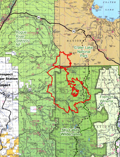
Lonesome Complex/Middlefork Fire (Repost)
Location: 21 mi NE of Prospect, Douglas Co., OR
Specific Location: Rogue River-Siskiyou NF, Middle Fork Rogue River near Halifax Cr in the Sky Lakes Wilderness, Lat 42 43 10. Long 122 15 50.
Date of origin: 08/16/2008
Cause: lightning
Situation as of 10/09/2008 4:00 PM
Personnel: 19
Size: 21,125 acres
Percent contained: 95%
Costs to date: $18,413,719
Mop-up is complete. Equipment is pulled and fire suppression impacts have been rehabilitated where needed.
***************
Situation as of 10/08/2008 7:00 PM
Personnel: 55
Size: 21,125 acres
Percent contained: 95%
Costs to date: $18,413,719
Rain and snow showers likely in the afternoon.Mop-up is complete. Equipment is pulled and fire suppression impacts are being rehabilitated where needed. Weather forecast for 10/9 is rain and showers likely. Mop up activities complete. Rehab efforts are ongoing.
Type 3 organization in place. Transitioning to a Type 4 team on 10/9/08 at 1500 hours.
***************
Situation as of 10/06/2008 6:30 PM
Personnel: 125
Size: 21,125 acres
Percent contained: 70%
Costs to date: $18,189,300
Estimated costs decreased due to actual costs and decrease of crew and air operations.
Tuesday mostly cloudy in the morning with a few rain showers. Mop-up is complete. Equipment is being pulled and fire suppression impacts are being rehabilitated where possible.
***************
Situation as of 10/05/2008 6:00 PM
Personnel: 97
Size: 21,125 acres
Percent contained: 50%
Costs to date: $18,060,000
Estimated costs decreased due to actual costs and decrease of crew and air operations.
Weather forecast for 10/6 promises warmer and drier conditions Monday afternoon.
Mop-up activities complete. Transfer of command to a Type 3 organization has occurred.
***************
Situation as of 10/04/2008 5:00 PM
Personnel: 115
Size: 21,125 acres
Percent contained: 50%
Costs to date: $18,600,000
Wetting rain received on the fire last night and today, much cooler and moister weather aided in reducing fire activity. Weather forecast for 10/5 promises an increase in rainfall and snow levels dropping to 5200 feet.
Mop-up is complete. Equipment is being pulled and fire suppression impacts are being rehabilitated where weather permits. Transfer of command to a Type 3 organization is scheduled for 0600 on October 4, 2008.
The breakdown of acres by ownership is: Crater Lake National Park – 2,017; Rogue River Siskiyou NF – 18,569; Fremont Winema NF - 539.
***************
Situation as of 10/02/2008 5:00 PM
Personnel: 328
Size: 21,125 acres
Percent contained: 50%
Costs to date: $18,300,000
Fire increased ~325 acres yesterday.
Widespread rainfall received on the fire today. Much cooler and moister weather aided in reducing fire activity and spread. Mop-up is progressing well on west and north flanks, equipment is being pulled and fire suppression impacts are being rehabilitated where possible.
***************
Situation as of 10/01/2008 5:00 PM
Personnel: 440
Size: 20,808 acres
Percent contained: 50%
Costs to date: $18,200,000
Fire increased ~120 acres yesterday.
Cooler and moister weather aided in reducing fire activity and spread. For October 2, rainfall near 0.25” is forecast.
Costs in this report are for the complex, however, acres and containment figures reflect the Middle Fork Fire only. The breakdown of acres by ownership is: Crater Lake National Park – 2,009; Rogue River Siskiyou NF – 18,307; Fremont Winema NF - 492.
***************
Situation as of 09/30/2008 5:00 PM
Personnel: 541
Size: 20,687 acres
Percent contained: 42%
Costs to date: $17,700,000
Fire increased ~640 acres yesterday.
Easterly winds are hitting the uncontained east flank of the fire and are pushing the fire back in on itself. Continued flanking action along north perimeter for burnout. Weather forecast for tomorrow (Wed) is nearing critical burning thresholds.
***************
Situation as of 09/29/2008 5:00 PM
Personnel: 521
Size: 20,045 acres
Percent contained: 42%
Costs to date: $17,000,000
Fire increased ~300 acres yesterday.
The breakdown of acres are: Crater Lake National Park - 1,927; Rogue River Siskiyou NF – 17,628; Fremont Winema NF - 490.
***************
Situation as of 09/28/2008 5:00 PM
Personnel: 787
Size: 19,748 acres
Percent contained: 42%
Costs to date: $16,300,000
Fire increased ~200 acres yesterday.
East winds are hitting the uncontained E flank of the fire and are pushing the fire back in on itself. Continued flanking action along N perimeter in CLNP for burnout.
Red Flag Warnings have been issued for 0300 to 2300 hours tomorrow (Monday).
Completing major mop-up activities. Rehab Plan has been developed and ongoing rehab efforts will be completed as soon as practicable. Cost are for the complex, however, acres and containment reflect the Middle Fork Fire only. The breakdown of acres are: Crater Lake National Park - 1,893; Rogue River Siskiyou NF – 17,365; Fremont Winema NF - 490.
Active burning in the ground fuels with single and group tree torching developing by mid-day. By afternoon, areas of previous spotting pulled together creating several plume columns across the fire, all inside of the containment lines.
***************
Situation as of 09/27/2008 5:00 PM
Personnel: 851
Size: 19,539 acres
Percent contained: 40%
Costs to date: $15,400,000
Fire increased ~175 acres yesterday.
A new Division (Lima) was staffed today, starting an indirect strategy to contain the north and east flanks of the fire. Deliberate Burnout of heritage old-growth Oregon Cascades forest was initiated in Division Kilo.
***************
Situation as of 09/26/2008 5:00 PM
Personnel: 936
Size: 19,263 acres
Percent contained: 35%
Costs to date: $14,700,000
Fire decreased ~100 acres yesterday; no explanation. Fire continues to spread in old-growth, esp to the S in Seven Lakes basin.
Continued flanking action along W and N perimeter for burnout.
WFSA # 4 has been certified by the Regional Forester.
HIGH PRESSURE WILL STRENGTHEN OVER THE REGION LEADING TO WARMER AND DRIER CONDITIONS. IN PARTICULAR UNSEASONABLY WARM DRY AND UNSTABLE CONDITIONS WILL EXIST SUNDAY AND MONDAY AFTERNOON ALONG WITH POOR RIDGETOP RECOVERIES THROUGH MONDAY NIGHT, ESPECIALLY OVER THE CASCADES AND SISKIYOUS. ON MONDAY AFTERNOON ISOLATED THUNDERSTORMS ARE FORECAST NEAR AND EAST OF THE CASCADES.
***************
Situation as of 09/25/2008 7:00 PM
Personnel: 1,036
Size: 19,361 acres
Percent contained: 35%
Costs to date: $13,900,000
Fire grew ~200 acres yesterday. Fire continues to spread in old-growth, esp to the S in Seven Lakes basin.
Continued progress with direct line to the north and east portion of the fire in the park.
The breakdown of acres by management unit are: Crater Lake Lake National Park (NPS)-1,743 acres; Rogue River-Siskiyou NF - 17,127 acres; Fremont-Winema NF - 491 acres.
***************
Situation as of 09/24/2008 5:00 PM
Personnel: 999
Size: 19,135 acres
Percent contained: 35%
Costs to Date: $13,092,572
Fire grew ~160 acres yesterday. Burnouts on SW and E perimeter of fire.
Continued progress with direct line to the north and east portion of the fire in the park.
PNW team 3 Type 1 IMT (Pendleton) assumed command at 0600 9/25.
***************
Doubleday Fire
Location: 1 mile S of Butte Falls, Jackson Co., OR
Specific Location: Hukill Creek to Doubleday Creek and S to Salt Creek Access Rd., Lat 42 30 24 Lon 122 33 56
Date of origin: 09/17/2008
Cause: not reported
Situation as of 09/22/2008 1:00 PM
Personnel: 286
Size: 1,275 acres
Percent contained 100%
Costs to Date: $2,671,707
Transition to local Type 3 organization (Simrell - IC) takes place at 1300 hr.
Minimal activity confined to stump holes and larger interior fuels.
***************
Situation as of 09/21/2008 1:00 PM
Personnel: 553
Size: 1,275 acres
Percent contained 95%
Barricades and limited access to the public are still in place. Containment expected to take place at end of shift today. Transition will take place tomorrow at 1300hr. Management of the incident will transfer to a local Type 3 organization.
Moderate temperature and relatively high humidity have created favorable firefighting conditions for holding line and mopping up. Continued consumption of heavy fuels continues where jackpots of blowdown still exist; tree torching and short-range spotting is still possible. Flare-ups and torching has occurred in areas where patchy burning has occurred.
***************
Situation as of 09/19/2008 1:00 PM
Personnel: 628
Size: 1,250 acres
Percent contained 75%
Fire progression north towards Butte Falls has been halted. ODF has laid water hose on perimeter. Cloud cover, lower temperature, and higher humidity provided favorable firefighting conditions.
Fire activity increased overnight in the NE portion of the fire and is expected to contine until line is complete in that portion. Probability of ignition from spots is 40-50%.
***************
Situation as of 09/18/2008 1:30 PM
Personnel: 441
Size: 750 acres (reported, at least 4 sq miles within perimeter)
Percent contained 5%
Fire progressing north, towards Butte Falls. Jackpots of heavy downed material burning actively. Fire has been lined, either direct or indirect. Dozer line constructed on
west side of fire. Hand line and dozer line constructed on east side of the fire.
MODIS satellite images this morning indicate the fire subsided overnight and is no longer progressing toward Butte Falls.
***************
Situation as of 09/18/2008 12:30 PM
Personnel: 169
Size: 600+ acres (~2,400 acres based on Google fire maps at 6:00 PM)
Percent contained 5%
Butte Falls on alert for possible evacuation. 160 residences, school, and 10 commercial buildings threatened.
ODF IMT 2 (Hunt) on fire. S winds pushing fire towards Butte Falls. Burning in heavy fuels, including blowdown and snags, in the Butte Falls watershed. Checkerboard ownership, private and BLM.
Lake Lenore Fire
Location: 11 miles N of Detroit Lake, Clackamas and Marion Cos., OR
Specific Location: Bull of the Woods Wilderness, Lat 44° 53´ 56″ Lon 122° 3´ 21″
Date of Origin: 08/16/2008 (first official report 09/18/08)
Cause: lightning
Situation as of 09/21/2008 at 5:00 PM
Personnel: 8
Size: 536 acres
Percent contained: 10%
Costs to Date: $475,000
No suppression, monitoring only. Old-growth fire. Backing, group tree torching and small uphill runs. No explanation for acreage reduction. Name of fire changed to “Clackamas Complex.” Last report from USFS. Big secret deal. Hush hush. Old-growth murder fire. Mums the word.
***************
Situation as of 09/18/2008 at 6:15 PM
Personnel: 20
Size: 650 acres
Percent contained: 0%
No suppression, monitoring only. Old-growth fire. Backing, group tree torching and small uphill runs.
***************
Situation as of 09/17/2008 at 8:00 PM
Personnel: 14
Size: 550 acres
Percent contained: 0%
Fire Behavior: Backing, group tree torching and small uphill runs.
Evidently a smoldering lightning strike that flared up yesterday. Old-growth westside Cascades forest. Trees up to 450 years old torching. Irreplaceable. Extreme resource destruction.
No initial attack. No attempt to contain, control, or extinguish. Fire is being “monitored.”
Shingle Mill WFU Fire
Location: 45 miles north of Kemmerer, Lincoln Co., WY
Specific Location: E of Harris River, Bridger-Teton NF, Lat 42° 13´ 29″ Lon 110° 42´ 12″
Date of Origin: 09/11/2008
Cause: lightning
Situation as of 10/01/2008 3:30 PM
Personnel: 10
Size: 1,110 acres
Percent contained: 0%
MMA: not reported
Costs to Date: not reported
Last report unless significant activity occurs.
***************
Situation as of 09/19/2008 8:00 AM
Personnel: 12
Size: 693 acres
Percent contained: 0%
MMA: not reported
Costs to Date: $40,000
Group tree torching with moderate range spotting up to 1/4 mile. Thundercell produced strong outflow east winds over a three hour period which contributed to fire growth to the west.
Stage II WFIP has been completed. Slowing and checking actions in front of Management Action Point 3.
***************
Situation as of 09/16/2008 5:30 PM
Personnel: 8
Size: 187 acres (old data)
Percent contained: 0%
MMA: not reported
Costs to Date: $20,000
Single to group tree torching with short range spotting. Fire doubled in size today (9/17)
Gnarl Ridge Fire (Repost)
Location: 14 miles S of Parkdale, Hood River Co., OR
Specific Location: Cold Springs Ck, 3 mi SW Cloud Cap Inn, Mt. Hood NF, Lat 45° 22´ 21″ Lon 121° 37´ 40″
Date of Origin: 08/08/08
Cause: Lightning
Situation as of 10/05/08 6:00 PM
Total Personnel: 132
Size: Size: 3,280 acres
Percent Contained: 90%
Costs to Date: $15,000,000
Transition and turnback from Type III IMT to district Type IV organization in progress. Demobilization of Type III project NLT 1700 tomorrow. Type IV organization will retain 2 crews, 2 engines and some overhead.
***************
Situation as of 10/04/08 5:00 PM
Total Personnel: 272
Size: Size: 3,280 acres
Percent Contained: 90%
Costs to Date: $14,900,000
Precipitation delayed today’s rehab operations due to road and flood safety concerns. In process of demobilizing operational resources to those needed for continued work after turnback to the district.
***************
Situation as of 10/02/08 5:00 PM
Total Personnel: 272
Size: Size: 3,280 acres
Percent Contained: 90%
Costs to Date: $14,500,000
Area closure reduced in size. Type III IMT assumed command at 0600. Significant demob of resources continued. Mopup and rehab continued on Divs D, G and K.
***************
Situation as of 10/01/08 3:00 PM
Total Personnel: 471
Size: Size: 3,280 acres
Percent Contained: 90%
Costs to Date: $14,200,000
The area closure is scheduled to be reduced in size effective tomorrow, Thursday, October 2, 2008.
The retardant was cleaned off of the historic structures at Cloud Cap. Yellow Spike, which had been used to spike up to 3 crews for suppression operations in Division M, was demobilized this afternoon.
A type 3 organization led by Type 3 IC Leo Segovia and trainee Matt White is scheduled to be delegated the responsibility for the suppression of this Incident as of 0600 hours, tomorrow, Thursday, October 2, 2008 at 0600 hours.
***************
Situation as of 09/30/08 3:00 PM
Total Personnel: 571
Size: Size: 3,280 acres
Percent Contained: 80%
Costs to Date: $13,800,000
Red Spike, which had been used to spike 4 crews for suppression operations in Division A, was demobilized this afternoon. Yellow Spike, which is being used to spike 3 crews for suppression operations in Division M, is scheduled to be demobilized tomorrow. The Area Closure has been reviewed and is expected to be reduced in size effective Thursday, October 2, 2008. Contractors will be allowed access to the Cloud Cap Inn beginning tomorrow to continue remodeling efforts which had started prior to the occurence of this Fire.
A Type 3 organization led by Type 3 IC Leo Segovia is scheduled to be delegated the responsibility for the suppression of this Incident as of 0600 hours, Thursday, October 2, 2008. A transition day for the Type 3 organization is expected to occur tomorrow, Wednesday, October 1, 2008.
Some open flame in unburned islands and in large fuels, otherwise creeping and smoldering fire.
***************
Situation as of 09/29/08 3:00 PM
Total Personnel: 613
Size: Size: 3,280 acres
Percent Contained: 70%
Costs to Date: $13,400,000
The existing closure order around the fire remains in effect. 7 crews were demobilized from the Incident today.
Some open flame in unburned islands and in large fuels, otherwise creeping and smoldering fire.
Night operations tonight includes 5 engines with overhead to patrol and mop up. For day operations tomorrow, initial attack all new starts in the initial attack responsibility area. Continue securing and mopping up containment lines. Continue to use the hand held Palm IR and the Helicopter RAM IR to identify heat targets to assist in the mop up operation. Continue using aviation resources to provide logistical support to the spike camps, to check the fire spread in the unlined areas, and to support ground crews in the suppression effort. Continue to mop up the unburned islands along the Cloud Cap access road. Continue to clean the retardant off of the Cloud Cap historic structures.
***************
Situation as of 09/28/08 3:00 PM
Total Personnel: 765
Size: Size: 3,280 acres
Percent Contained: 65%
Costs to Date: $12,800,000
Progress is being made in securing containment lines and mopping up on all perimeter. Flew the fire perimeter today with helicopter FLIR to identify heat targets to assist in the mop up.
Some open flame in large fuels and within unburned islands, otherwise creeping and smoldering fire.
***************
Situation as of 09/27/08 3:00 PM
Total Personnel: 774
Size: Size: 3,280 acres
Percent Contained: 60%
Costs to Date: $12,350,000
Continued good progress is being made securing containment lines and mopping up on all fire perimeter. Incident personnel began cleaning the retardant off of the historic structures at Cloud Cap today. Five IHC crews from the SW are scheduled for demobilization on Monday September 29, 2008.
***************
Situation as of 09/26/08 3:00 PM
Total Personnel: 774
Size: Size: 3,280 acres
Percent Contained: 50%
Costs to Date: $11,700,000
The level 3 evacuation notice for the subdivisions in the Cooper Spur area has been reduced to a Level 1 as of 1200 hours today.
A containment line has now been established on the perimeter, however, there are several portions on the perimeter where the containment lines are natural barriers tied into glaciers.
Securing and mopping up containment lines. Using Palm IR units to assist with the mop up operations. Continuing with excavator suppression rehabilitation and chipping operations on contingency containment lines and access roads. Continuing with BAER team assessment. Using air resources to provide logistical support to the 2 spike camps, for bucket work in the suppression effort, and backhaul of excess material from the spike camps.
***************
Situation as of 09/25/08 3:00 PM
Total Personnel: 807
Size: Size: 3,280 acres
Percent Contained: 38%
Costs to Date: $10,900,000
The Level 3 evacuation notice for the subdivisions in the Cooper Spur area remains in effect, it is tentatively scheduled to be reduced to a Level 1 9/26/2008 at 1200 hours.
No change in acreage reported, minimal perimeter growth. Approximately 0.25 inches of precipitation fell over the fire area beginning yesterday evening and through the night. Fire most active above Cold Springs Ck on the E side of Mt Hood.
For night operations tonight 9/25/2008, use 5 engine crews to continue with structure protection and for mop up. For day operations tomorrow, 9/26/2008, continue establishing, securing, and mopping up containment lines on the fire perimeter. Continue with excavator suppression rehabilitation and chipping operations on the indirect contingency containment lines and access roads. Continue with hazard tree felling for fire fighter safety on all fire perimeter and on the access roads. Begin with the BAER team assessment. Continue using air resources to provide logistical support to the 2 spike camps, for bucket work with the suppression effort, for BAER assessment reconaissance, and backhaul of excess material from the spike camps.
***************
Royce Butte Fire
Location: Crescent Lake, Klamath Co. OR
Specific Location: ~Lat 43 33 31, ~Lon 121 52 51
Date of Origin: 09/16/08
Cause: human
Situation as of 09/30/2008 at 6:00 PM
Personnel: not reported
Size: 381 acres
Percent contained: 100%
Costs to Date: not updated
Fire declared controlled today. [There are 3 stages in firefighting: contain, control, and extinguish. Roughly speaking, contain means get a line around it, control means no more flames, extinguish means no more smokes, fire dead out. - Ed]
***************
Situation as of 09/20/2008 at 7:00 PM
Personnel: 250
Size: 381 acres
Percent contained: 100%
Costs to Date: $1,340,513
Transitioned to local Type 3 Team 9/21.
***************
Situation as of 09/19/2008 at 7:00 PM
Personnel: 371
Size: 381 acres
Percent contained: 80%
Costs to Date: $1,042,004
Highway 58 opened to the public, evacuation lifted and changed to level 2.
Minimal fire behavior. Continue mop up, patrol, rehab and remove equipment. Expected transition to local Type 3 Team on 9/21.
***************
Situation as of 09/18/2008 at 7:00 PM
Personnel: 336
Size: 381 acres
Percent contained: 60%
Costs to Date: $699,707
Highway 58 opened to the public, evacuation lifted and changed to level 2.
Oregon State Fire Marshall Red Team demobed yesterday.
Minimal fire behavior, smoldering and creeping in needle litter.
***************
Situation as of 09/17/2008 at 7:00 PM
Personnel: 238
Size: 381 acres
Percent contained: 20%
Costs to Date: $375,000
Highway 58 remains closed and residences and businesses of Crescent Junction remain evacuated. Community meeting last night.
Acres decreased due to more accurate gps mapping of fire perimeter.
Active burning in jackpots of fuel and spot fires. Some smoldering and creeping fire. Good progress made with dozer line on fire. Continue line improvement and construction, locate spot fires, protect structures and improvements.
***************
Situation as of 09/16/2008 at 6:00 PM (posted 7:00 AM 9/17)
Personnel: 155
Size: 1,100 acres
Percent contained: 0%
First official report. Evacuation of Crescent Lake Junction community, E Odell Lodge and all summer homes at Crescent and Odell Lakes; Diamond Peaks subdivision (located E of Crescent Lake Junction).
The American Red Cross Oregon Mountain River Chapter mobilized volunteers and gear to set up a shelter at the Crescent Community Center.
Fire crossed Hwy 58 at the airstrip N of CLJ. Active fire with crown runs and long range spotting, erratic high winds with gusts to 40mph. Intense burning observed.
Central Oregon Type 2 IMT (Rapp) requested and on the way.
***************
Situation as of 09/16/2008 at 10:00 PM
Personnel: 150+
Size: 600+ acres
Percent contained: unknown
No official reports, but one TV station is calling it the Royce Butte Fire. All reports on this fire so far are unofficial. (11 PM report KTVZ Bend [here])
***************
Situation as of 09/016/2008 at 6:00 PM
Personnel: unknown
Size: 100+ acres
Percent contained: unknown
Evacuation of homes, a resort, and campgrounds is underway. Highway 58 is closed E of Willamette Pass. The next route to the S across the Cascades is Highway 138, which is also closed due to the Rattle Fire.
From KVAL Eugene [here]:
The fire grew to more than 100 acres in less than three hours Tuesday afternoon and was moving fast. The fire was started by human activity, but exactly how is not yet known, according to Virginia Gibbons with the Deschutes National Forest.
The fire jumped containment lines as a thunderstorm passed through the area. The wind and unstable air pushed the flames past bulldozers working to contain the fire.
Ten fire trucks are on the ground right now with one light helicopter and four air tankers dumping water and fire retardant on the blaze.
The Oregon Department of Transportation closed Highway 58 from milepost 61 to 73 due to the fire.
The fire jumped Hwy. 58 and is burning on both sides, according to recent reports.
Klamath Fire Theater
Location: Northern California, principally Klamath NF but also portions of the Six Rivers NF and Shasta-Trinity NF
Date of Origin: 06/21/2008
Cause: Lightning
Situation as of 10/05/2008 at 4:30 PM
Personnel: 262
Size: 72,344 acres (Panther Fire only)
Percent contained: 25%
Costs to Date: not reported, est actual $160 million for the Klamath Fire Theater. Fires in the Theater include the Siskiyou Complex, Ukonom, Blue 2, Panther, and Bear Wallow Complex.
For the first time in two weeks a 209 report has been posted. The report is for the Panther Fire only, but may include portions of other fires. The USFS has been combining, dividing, and recombining fires to obfuscate fire statistics and cover up actual fire conditions.
Despite two weeks of silence, the Panther Fire continues to burn and firefighters continue to work the fire. Command of the fire has devolved to a local (Klamath NF) fire team. Continuing firefighting efforts include direct line construction out of Elk Creek, containment and mop-up on Doolittle and Cougar Creeks and direct line construction from Sulfur Springs to the E.
***************
Situation as of 09/25/2008 at 6:00 PM
Personnel: 276
Size: 192,038 acres
Percent contained: 90%
Costs to Date: $126,086,065 reported, est actual $155 million.
Fire now officially 3 months old. Fire size increased 1,050 acres in the last 2 days. Fire activity near the areas of Blue Granite, Burney, and Deadman Lakes, Little North Fork Creek, Chimney Rock, Harrington’s Ridge, the Dillon Divide area, and the Marble Mtns.
A transfer of command from the Boise NIMO team to the local forests will occur on Friday, September 26 at 0600 hrs. The Blue 2/Siskiyou fire will be transferred to the Six Rivers National Forest; the North Ukonom, South Ukonom, Panther, Anthony Milne, and Caribou fires will be transferred to the Klamath National Forest.
***************
Situation as of 09/23/2008 at 6:00 PM
Personnel: 345
Size: 190,964 acres
Percent contained: 90%
Costs to Date: not reported, est $155 million.
Fire now officially 3 months old. Fire size increased 360 acres in the last 2 days. Fire activity near Medicine Mountain and Chimney Rock, Harrington Creek and Eightmile Creek, Upper Dillon Creek, Bridge Creek, Blue Creek, Pleasant Lake, and the Marble Mountain Wilderness.
***************
Situation as of 09/21/2008 at 6:00 PM
Personnel: 422
Size: 190,601 acres
Percent contained: 75%
Costs to Date: $124,849,322 reported. Actual costs over $150 million.
Fire now officially 3 months old. Fire size increased 1,500 acres in the last 2 days. Fire spread near Medicine Mountain and Chimney Rock was monitored by air. The Blue 2 fire spread into Harrington Creek and Eightmile Creek. Backing, smoldering and creeping were observed in the areas of the Dillon Divide and Blue Creek (Blue 2/Siskiyou fire) as well as in the vicinity of Pleasant Lake (Panther fire) and into the Marble Mountain Wilderness (South Ukonom fire).
***************
Situation as of 09/19/2008 at 6:00 PM
Personnel: 411
Size: 189,173 acres
Percent contained: 75%
Costs to Date: $124,636,917 reported. Another $4 million missing. See discussion on 09/17 below.
Estimated Containment date: 09/30/2008
Fire size increased 3,000 acres in the last 2 days. Fire spread near Medicine Mountain and Chimney Rock was monitored by air. The Blue 2 fire spread into Harrington Creek and Eightmile Creek last night and early this morning.
***************
Situation as of 09/17/2008 at 6:00 PM
Personnel: 447
Size: 185,925 acres
Percent contained: 75%
Costs to Date: see below
Estimated Containment date: 09/30/2008
Fire size increased 2,500 acres in the last 2 days.
Crews continued to monitor the fire spread. Increase in winds coupled with extremely dry fuel conditions making for increased fire behavior. South Ukonom: Active fire behavior north of Crapo Mountain in the Devils Canyon area and on northeast perimeter. Single and group tree torching. Siskiyou/Blue 2: Actively burning in upper extents of Blue and Dillon Creeks. Fire has moved beyond Chimney Rock and threatening to cross Dillon Divide. Panther: Interior bowls are burning with intermittent short runs to ridge tops. Burning into upper end of Pleasant Lake.
Costs and size clarifications: The Bear Wallow Complex consists of the Caribou, South Ukonom and Anthony Milne fires. The Panther Fire consists of the Panther Fire and the North Ukonom fires. The Siskiyou Complex consists of the Siskiyou and Blue 2 fires. There are five cost databases associated with three incident numbers; for cost reporting purposes, the Bear Wallow Complex costs will include the Caribou, North Ukonom, South Ukonom, and Anthony Milne fires. The Panther fire costs will include only the Panther fire, and the Siskiyou Complex costs will include the Siskiyou and Blue 2 fires. The Panther Fire is currently 50,905 acres with a cost to date of $41,724,876. The Bear Wallow Complex is currently 49,869 acres with a cost to date of $16,311,770. The Siskiyou Complex is currently 85,151 acres with a cost to date of $70,428,649. Cost to date by individual fires: Ukonom - $25,740,777; Siskiyou - $44,696,871; Blue 2 - $20,731,778; Panther - $15,984,099; Bear Wallow - $16,311,770. The change in cost to date is a result of cleaning up multiple databases.
[If you read through that carefully with a calculator in hand, you will realize that it is self-contradictory and that the numbers do not add up. The costs to date for the individual fires are too low by many $millions. It calls into question the entire accounting. Four days ago total costs were given as $150,804,771. That accounting was understated by $23 - $25 million based on our tracking. Tens of millions of dollars are missing from today's figures. - Ed]
***************
Situation as of 09/15/2008 at 6:00 PM
Personnel: 575
Size: 183,453 acres
Percent contained: 75%
Costs to Date: not updated, est. $176 million
Estimated Containment date: 09/30/2008
Fire size increased 2,000 acres in the last 2 days.
On the South Ukonom fire, fire activity increased this afternoon with moderate intensity understory burning in timber with occasional individual tree or group torching. Extremely dry fuel conditions persist. On the Panther Fire, bowls in the high country continue to exhibit interior growth. On the Siskiyou/Blue 2 fire, increased activity was observed in the Elk Valley and Blue Creek drainage areas.
Local Red Flag Warning conditions predicted for 9/16/08: for unstable air conditions, high temperatures, low humidity, and isolated dry lightning in the area.
***************
Situation as of 09/13/2008 at 6:00 PM
Personnel: 643
Size: 181,514 acres
Percent contained: 75%
Costs to Date: $150,804,771 (the largest suppression cost ever reported in history)
Estimated Containment date: 09/30/2008
The Klamath Theater consists of the Bear Wallow Complex (CA-KNF-3393) [here], the Panther Fire (CA-KNF-003624) [here], and the Siskiyou/Blue 2 Complex (CA-KNF-002975) [here]. The Bear Wallow Complex consists of the Caribou, South Ukonom [here] and Anthony Milne fires. The Panther Fire consists of the Panther Fire and the North Ukonom fires [here]. The Siskiyou/Blue 2 Complex consists of the Siskiyou and Blue 2 fires. Branches were redefined to reflect the additional fires as well as for organizational efficiency. The Panther Fire is currently 49,537 acres with a cost to date of $15,802,871. The Bear Wallow Complex is currently 49,361 acres with a cost to date of $14,804,959. The Siskiyou/Blue 2 Complex is currently 82,616 acres with a cost to date of $120,196,941. All resources for the entire theater are being reported under this ICS 209.
[Correction: the costs reported above DO NOT include the costs of the Ukonom Fire prior to incorporation into the Panther and Bear Wallow Fires. And additional $23 million (at least) was spent on the Ukonom Fire.- Ed]
Injuries and fatalities reflect all complexes. There have been 3 fatalities, most recently Sept. 11 from a dozer accident that occurred Sept 6.
Crews continued to monitor the fire spread, patrol and mop as necessary. Due to firefighter safety and sensitive resource concerns, all ground resources were removed from the Elk Valley area on the Siskiyou/Blue 2 Branch where the most recent fatality occurred.
Crews continued to construct handline on the South Ukonom Fire from the Little North Fork of the Salmon River northeast toward the wilderness boundary in preparation for burning out. Crews completed handline on the ridgeline between Sur and Cherry Creeks, completed firing operations to the Little North Fork Creek of the Salmon River, and continued to hold and mop up.
A low intensity fire with some isolated torching was observed on the Panther and South Ukonom fires. The Bear Wallow Complex fire behavior has remained fairly constant the last three days, experiencing moderate intensity fire with group torching.
