Chalk Fire
Location: 25 miles S of Big Sur, Monterey Co. CA
Specific Location: E of Lucia, Nacimiento-Fergusson Rd., Los Padres NF, Lat 35° 59´ 25″ Lon 121° 25´ 48″ [~15 mi S of Basin/Indian Complex]
Date of Origin: 09/27/2008
Cause: Under investigation
Situation as of 10/30/2008 at 6:00 PM
Personnel: 106
Size: 16,269 acres
Percent contained: 100%
Costs to Date: $23,982,486
Cone Peak Road remains closed until further notice per Monterey District Office.
Interior burning of unburned fuel, creeping and smoldering continues. With predicted rain, crews will not be on the line. Rehab will continue once rains are finished and conditions are suitable.
***************
Situation as of 10/27/2008 at 6:00 PM
Personnel: 166
Size: 16,269 acres
Percent contained: 98%
Costs to Date: $23,734,000
CCIIMT 7 transferred command to a type 3 organization (Mark Nunez ICT3) today, Monday, October 27, 2008 at 0600 hours. All road closures have been removed today at 1200 hours, except for Cone Peak Road which will remain closed until further notice per Monterey District Office. The containment date has been pushed to 10-29-2008 to allow for the transition of command to the type 3 organization and to allow an additional day for rehab work.
Interior burning of unburned fuel, creeping and smoldering.
*************
Situation as of 10/21/2008 at 6:00 PM
Personnel: 654
Size: 15,359 acres
Percent contained: 80%
Costs to Date: $20,000,000
3-4 slopovers / spotfires reported in Div. Y that are being picked up with crews, dozers and aircraft.
*************
Situation as of 10/20/2008 at 6:00 PM
Personnel: 633
Size: 15,359 acres
Percent contained: 80%
Costs to Date: $18,800,000
Continue Firing Operation along the Hermitage Road to the South. A coastal buffer zone of natural vegetation (minimum of 300′) is being left in order to protect Highway 1 from future winter storm activity. Contingency Dozer line at the North edge of Lime Kiln State Park is being completed today. This line will protect the Hermitage and Lime Kiln areas. Preparation for possible burning along this line continues to progress. Approval received for the construction of dozer line from apex medi-vac helispot north to Gamboa ridge.
*************
Situation as of 10/17/2008 at 3:00 PM
Personnel: 338
Size: 12,010 acres
Percent contained: 93%
Costs to Date: $17,023,259 (no explanation for reduction in costs)
Evacuation Warning for Lime Kiln and Hermitage
Fire flaring up again. CCIIMT7 team ordered for incident. In brief on 10.17.08 at 1800 hours with transition scheduled for 10.18.08 at 0600.
*************
Situation as of 10/15/2008 at 5:00 PM
Personnel: 215
Size: 11,310 acres
Percent contained: 97%
Costs to Date: $17,203,000
Continued creeping fire activity in the Hare Creek area. The remainder of the fire perimeter continues to smolder with isolated hot spots. Crews will complete contingency line W of Hare Creek. Continue to mop up and patrol.
*************
Situation as of 10/13/2008 at 4:00 PM
Personnel: 144
Size: 11,210 acres
Percent contained: 97%
Costs to Date: $16,253,470
Increased fire activity in the Hare Creek area. Fire behavior in the remainder of the fire perimeter continues to be smoldering with isolated hot spots.
*************
Situation as of 10/12/2008 at 4:00 PM
Personnel: 144
Size: 11,189 acres
Percent contained: 97%
Costs to Date: $15,341,000
Smoldering with isolated hot spots.
*************
Situation as of 10/11/2008 at 5:00 PM
Personnel: 145
Size: 11,189 acres
Percent contained: 97%
Costs to Date: $15,341,000
Type 3 organization (Kremke) assumed command at 0600.
The remainder of the uncontained perimeter is inaccessible terrain (100% slope) and is not safe for firefighters to work. The area was flown today with the use of IR to monitor activity. There had been no movement reported in this area for several days.
*************
Situation as of 10/10/2008 at 6:00 PM
Personnel: 696
Size: 11,189 acres
Percent contained: 97%
Costs to Date: $14,756,000
Command of this incident will transition from Central Coast Team 7 (Smith) to a Type 3 Organization (Kremke) Saturday, 10/11/2008, at 0600. Daily IR flights are being utilized to identify remaining hot spots. Smoldering with isolated hot spots on the interior. Demob.
*************
Situation as of 10/08/2008 at 6:00 PM
Personnel: 1,048
Size: 11,189 acres
Percent contained: 69%
Costs to Date: $13,293,000
The evacuation watch has been lifted by Monterey County Sheriff Dept.
Weather conditions transitioning back to warmer and dryer over the fire area. Remarks: We will begin utilizing a 24 hour daily plan today due to minimal night time staffing. Current efforts focus on containment of northwest and southeast Corners. Continued mop-up and rehab where needed. Patrol of accessible fire area overnight. Remainder of open fire line is not safely accessible at night due to terrain.
*************
Situation as of 10/07/2008 at 6:00 PM
Personnel: 1,322
Size: 11,189 acres
Percent contained: 69%
Costs to Date: $11,979,000
Structures Threatened: 9 residences , 15 outbuildings
Crews began fire suppression rehab in addition to continued mop-up. Weather conditions transitioning back to warmer dryer conditions over the fire area. Constructing direct fire line on large fingers continues in extremely steep rugged terrain making overall containment a slow process. Smoldering with some down dead and snags openly burning.
Unified command will terminate at 0600 hrs. on 10-8-08.
*************
Situation as of 10/06/2008 at 6:00 PM
Personnel: 1,327
Size: 11,189 acres
Percent contained: 67%
Costs to Date: $10,843,000
Structures Threatened: 9 residences , 15 outbuildings
The reduction in the “fire line to build” figure reflect a change in fire suppression tactics. Earlier on the fire, crews were having to construct indirect line because of active burning conditions. As a result of the rain on 10/4 and its affect on fuel conditions, firefighters are now able to do more direct line construction which more closely follows the fire’s perimeter.
Crews continue the arduous task of seeking opportunities for direct line construction. Structure protection remains a priority. [direct quote; apparently the fire crews are not used to the arduous task of building direct fire lines and so the job requires superlatives in the 209 report. - Ed]
*************
Situation as of 10/05/2008 at 6:00 PM
Personnel: 1,228
Size: 12,168 acres reported (no update)
Percent contained: 37%
Costs to Date: $9,697,000
Structures Threatened: 9 residences , 15 outbuildings
Evacuation Warning has been lifted. Evacuation Watch orders are still in place by Monterey County Sheriff Dept.
Current efforts focus on containment of northwest corner and holding southwest flank.
*************
Situation as of 10/04/2008 at 6:00 PM
Personnel: 1,319
Size: 12,168 acres
Percent contained: 30%
Costs to Date: $8,430,000
Structures Threatened: 19 residences , 30 outbuildings
Fire increased in size ~1,500 acres today. The fire burned through a track of residences on the south flank. Due to successful suppression efforts no homes were destroyed by fire. Minimal damage was reported.
Traffic flow on Hwy 1 was affected intermittently today due to fire equipment activity.
Current efforts focus on containment of northwest corner and holding southwest flank.
*************
Situation as of 10/03/2008 at 6:00 PM
Personnel: 1,494
Size: 10,650 acres
Percent contained: 20%
Costs to Date: $7,282,909
Structures Threatened: 19 residences , 30 outbuildings
Fire increased in size ~600 acres today. The fire burned through a track of residences on the south flank. Due to successful suppression efforts no homes were destroyed by fire. Minimal damage was reported.
Traffic flow on Hwy 1 was affected intermittently today due to fire equipment activity.
Majority of containment effort continues on the west flank to protect structures and to minimize impact to Hwy 1. Forecasted weather (approaching cold front, strong winds) may hamper suppression efforts for next 12 hours.
*************
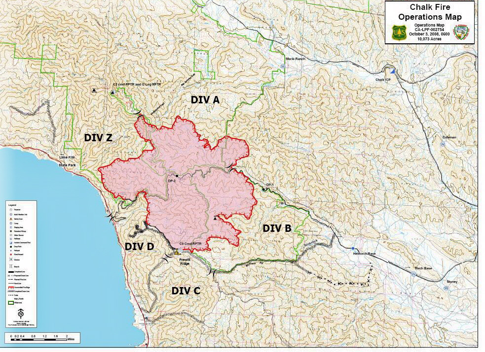
Situation as of 10/03/2008 at 7:00 AM
Personnel: 1,489
Size: 10,073 acres
Percent contained: 20%
Costs to Date: $5,800,000
Structures Threatened: 32 residences , 45 outbuildings
Fire doubled in size over the last 48 hours, or more accurate reporting is taking place. A public meeting was held with Big Sur Coast residence today to discuss fire conditions.
Measurable rain predicted in fire area Friday/Saturday. Good thing, because fire suppression efforts are nil or totally ineffective, or both.
Map below is 2 hours old. Click on map for larger image.
***************
Situation as of 10/02/2008 at 7:00 AM
Personnel: 1,473
Size: 7,079 acres
Percent contained: 20%
Costs to Date: not updated
Structures Threatened: 18 residences , 18 outbuildings
Moderate rate of spread reported. Considering the fire is expanding 2,000 acres a day, that remark is relative and subjective. Acreage estimate beginning to approach reality.
***************
Situation as of 10/01/2008 at 6:00 PM
Personnel: 1,410
Size: 5,050 acres
Percent contained: 13%
Costs to Date: $3,100,000
Structures Threatened: 18 residences , 18 outbuildings
Significant cost increase due to addition of Air Ops cost over past four days. Threat to commercial buildings has been removed due to successful protection efforts as fire moved through. [Unclear what commercial buildings this refers to. It could be the USFS facility on Nacimiento-Fergusson Rd. near the Coast Ridge Trail.]
Fire is much larger than reported. MODIS satellite indicates hot spots in Hare Canyon near the coast at Lime Kiln State Park, S of Chalk Peak, and E to USFS/Hunter Liggett boundary. The area indicated on the MODIS maps seems to exceed 8,000 acres.
***************
Situation as of 09/30/2008 at 6:00 PM
Personnel: 1,326
Size: 3,453 acres
Percent contained: 8%
Costs to Date: $1,800,000
11 people advised to evacuate in Dempsey Flat area and Beiar Property.
Occasional slope runs, moderate rate of spread, rollout pushing fire down slope. Large smoke plumes.
This incident will be in unified command with Fort Hunter Liggett at 0600 10/01/08.
***************
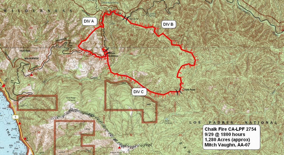
Situation as of 09/29/2008 at 6:00 PM
Personnel: 830
Size: 1,708 acres
Percent contained: 5%
Acreage is underestimated. According to MODIS satellite images the fire extends from Lime Kiln State park S to Chalk Peak and is ~ 4 mi long by 3 mi wide. That would put the fire at over 7,500 acres. More updates/corrections soon.
Update Tuesday, 09/30/2008, at 8 AM
Personnel 1,100+. 12 residences threatened and evacuated. Fire near homes, but no reports of structures lost as yet. MODIS satellite images may be wrong, because acreage still being reported at less than 2,000 acres. Map below is 12 hours old. Click on map for larger image.