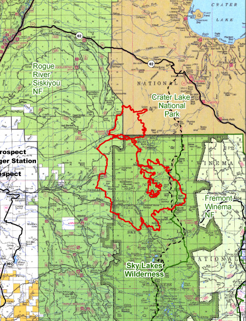
Lonesome Complex/Middlefork Fire (Repost)
Location: 21 mi NE of Prospect, Douglas Co., OR
Specific Location: Rogue River-Siskiyou NF, Middle Fork Rogue River near Halifax Cr in the Sky Lakes Wilderness, Lat 42 43 10. Long 122 15 50.
Date of origin: 08/16/2008
Cause: lightning
Situation as of 10/09/2008 4:00 PM
Personnel: 19
Size: 21,125 acres
Percent contained: 95%
Costs to date: $18,413,719
Mop-up is complete. Equipment is pulled and fire suppression impacts have been rehabilitated where needed.
***************
Situation as of 10/08/2008 7:00 PM
Personnel: 55
Size: 21,125 acres
Percent contained: 95%
Costs to date: $18,413,719
Rain and snow showers likely in the afternoon.Mop-up is complete. Equipment is pulled and fire suppression impacts are being rehabilitated where needed. Weather forecast for 10/9 is rain and showers likely. Mop up activities complete. Rehab efforts are ongoing.
Type 3 organization in place. Transitioning to a Type 4 team on 10/9/08 at 1500 hours.
***************
Situation as of 10/06/2008 6:30 PM
Personnel: 125
Size: 21,125 acres
Percent contained: 70%
Costs to date: $18,189,300
Estimated costs decreased due to actual costs and decrease of crew and air operations.
Tuesday mostly cloudy in the morning with a few rain showers. Mop-up is complete. Equipment is being pulled and fire suppression impacts are being rehabilitated where possible.
***************
Situation as of 10/05/2008 6:00 PM
Personnel: 97
Size: 21,125 acres
Percent contained: 50%
Costs to date: $18,060,000
Estimated costs decreased due to actual costs and decrease of crew and air operations.
Weather forecast for 10/6 promises warmer and drier conditions Monday afternoon.
Mop-up activities complete. Transfer of command to a Type 3 organization has occurred.
***************
Situation as of 10/04/2008 5:00 PM
Personnel: 115
Size: 21,125 acres
Percent contained: 50%
Costs to date: $18,600,000
Wetting rain received on the fire last night and today, much cooler and moister weather aided in reducing fire activity. Weather forecast for 10/5 promises an increase in rainfall and snow levels dropping to 5200 feet.
Mop-up is complete. Equipment is being pulled and fire suppression impacts are being rehabilitated where weather permits. Transfer of command to a Type 3 organization is scheduled for 0600 on October 4, 2008.
The breakdown of acres by ownership is: Crater Lake National Park – 2,017; Rogue River Siskiyou NF – 18,569; Fremont Winema NF - 539.
***************
Situation as of 10/02/2008 5:00 PM
Personnel: 328
Size: 21,125 acres
Percent contained: 50%
Costs to date: $18,300,000
Fire increased ~325 acres yesterday.
Widespread rainfall received on the fire today. Much cooler and moister weather aided in reducing fire activity and spread. Mop-up is progressing well on west and north flanks, equipment is being pulled and fire suppression impacts are being rehabilitated where possible.
***************
Situation as of 10/01/2008 5:00 PM
Personnel: 440
Size: 20,808 acres
Percent contained: 50%
Costs to date: $18,200,000
Fire increased ~120 acres yesterday.
Cooler and moister weather aided in reducing fire activity and spread. For October 2, rainfall near 0.25” is forecast.
Costs in this report are for the complex, however, acres and containment figures reflect the Middle Fork Fire only. The breakdown of acres by ownership is: Crater Lake National Park – 2,009; Rogue River Siskiyou NF – 18,307; Fremont Winema NF - 492.
***************
Situation as of 09/30/2008 5:00 PM
Personnel: 541
Size: 20,687 acres
Percent contained: 42%
Costs to date: $17,700,000
Fire increased ~640 acres yesterday.
Easterly winds are hitting the uncontained east flank of the fire and are pushing the fire back in on itself. Continued flanking action along north perimeter for burnout. Weather forecast for tomorrow (Wed) is nearing critical burning thresholds.
***************
Situation as of 09/29/2008 5:00 PM
Personnel: 521
Size: 20,045 acres
Percent contained: 42%
Costs to date: $17,000,000
Fire increased ~300 acres yesterday.
The breakdown of acres are: Crater Lake National Park - 1,927; Rogue River Siskiyou NF – 17,628; Fremont Winema NF - 490.
***************
Situation as of 09/28/2008 5:00 PM
Personnel: 787
Size: 19,748 acres
Percent contained: 42%
Costs to date: $16,300,000
Fire increased ~200 acres yesterday.
East winds are hitting the uncontained E flank of the fire and are pushing the fire back in on itself. Continued flanking action along N perimeter in CLNP for burnout.
Red Flag Warnings have been issued for 0300 to 2300 hours tomorrow (Monday).
Completing major mop-up activities. Rehab Plan has been developed and ongoing rehab efforts will be completed as soon as practicable. Cost are for the complex, however, acres and containment reflect the Middle Fork Fire only. The breakdown of acres are: Crater Lake National Park - 1,893; Rogue River Siskiyou NF – 17,365; Fremont Winema NF - 490.
Active burning in the ground fuels with single and group tree torching developing by mid-day. By afternoon, areas of previous spotting pulled together creating several plume columns across the fire, all inside of the containment lines.
***************
Situation as of 09/27/2008 5:00 PM
Personnel: 851
Size: 19,539 acres
Percent contained: 40%
Costs to date: $15,400,000
Fire increased ~175 acres yesterday.
A new Division (Lima) was staffed today, starting an indirect strategy to contain the north and east flanks of the fire. Deliberate Burnout of heritage old-growth Oregon Cascades forest was initiated in Division Kilo.
***************
Situation as of 09/26/2008 5:00 PM
Personnel: 936
Size: 19,263 acres
Percent contained: 35%
Costs to date: $14,700,000
Fire decreased ~100 acres yesterday; no explanation. Fire continues to spread in old-growth, esp to the S in Seven Lakes basin.
Continued flanking action along W and N perimeter for burnout.
WFSA # 4 has been certified by the Regional Forester.
HIGH PRESSURE WILL STRENGTHEN OVER THE REGION LEADING TO WARMER AND DRIER CONDITIONS. IN PARTICULAR UNSEASONABLY WARM DRY AND UNSTABLE CONDITIONS WILL EXIST SUNDAY AND MONDAY AFTERNOON ALONG WITH POOR RIDGETOP RECOVERIES THROUGH MONDAY NIGHT, ESPECIALLY OVER THE CASCADES AND SISKIYOUS. ON MONDAY AFTERNOON ISOLATED THUNDERSTORMS ARE FORECAST NEAR AND EAST OF THE CASCADES.
***************
Situation as of 09/25/2008 7:00 PM
Personnel: 1,036
Size: 19,361 acres
Percent contained: 35%
Costs to date: $13,900,000
Fire grew ~200 acres yesterday. Fire continues to spread in old-growth, esp to the S in Seven Lakes basin.
Continued progress with direct line to the north and east portion of the fire in the park.
The breakdown of acres by management unit are: Crater Lake Lake National Park (NPS)-1,743 acres; Rogue River-Siskiyou NF - 17,127 acres; Fremont-Winema NF - 491 acres.
***************
Situation as of 09/24/2008 5:00 PM
Personnel: 999
Size: 19,135 acres
Percent contained: 35%
Costs to Date: $13,092,572
Fire grew ~160 acres yesterday. Burnouts on SW and E perimeter of fire.
Continued progress with direct line to the north and east portion of the fire in the park.
PNW team 3 Type 1 IMT (Pendleton) assumed command at 0600 9/25.
***************
Situation as of 09/23/2008 5:00 PM
Personnel: 1,117
Size: 18,970 acres
Percent contained: 35%
Costs to Date: $12,270,131
Fire grew ~550 acres yesterday. A burnout was conducted in Red Blanket Creek.
Continued progress with direct line to the north and east portion of the fire in the park.
PNW team 3 Type 1 IMT (Pendleton) to take over fire today.
***************
Situation as of 09/22/2008 5:00 PM
Personnel: 1,249
Size: 18,238 acres
Percent contained: 28%
Costs to Date: $11,380,951
Fire grew ~350 acres yesterday. A burnout was conducted in Red Blanket Creek.
Bulletin: Direct line construction in Park to stop northerly spread. Also, started direct checking action with 2 IHCs in Wilderness on the Fremont-Winema side of the crest of the Cascades.
Repeat — for the first time at this fire, after a month of conflagration, after $11 million spent, actual firefighting is occurring. Hallelujah. Better late than never. Too bad about the 18,000 acres of priceless heritage forests destroyed, though.
The Blue Mountain Type 2 IMT (Batten) is preparing for a transition on 9/24 with the PNW TEAM 3 Type 1 IMT (Pendleton).
***************
Situation as of 09/21/2008 5:00 PM
Personnel: 1,081
Size: 17,869 acres
Percent contained: 28%
Costs to Date: $10,424,383
Fire growth in Crater Lake NP. No suppression activitites. Continued to prep east side for possible burnout operations. Annie Spike Camp is well established. Catering, laundry, other amenity services for 1,000+ personnel who are not engaged in fire suppression activities.
***************
Situation as of 09/19/2008 5:00 PM
Personnel: 912
Size: 17,808 acres (reported but an underestimate)
Percent contained: 20%
Costs to Date: $8,532,187
Costs are for the complex, however acres and containment reflect the Middle Fork Fire. The breakdown of acres are: Crater Lake National Park (NPS)-1,544; Rogue River NF - 15,920; Fremont Winema NF - 437.
Fire gained at least ~2,300 acres yesterday. Indirect line building on W perimeter.
***************
Situation as of 09/18/2008 5:00 PM
Personnel: 678
Size: 15,500 acres (reported but an underestimate)
Percent contained: 15%
Costs to Date: $7,843,075
The fire spread into the Crater National Park. Fire front now north of Union Peak. Active fire in Red Blanket Creek.
Fire gained at least 6,000 acres yesterday. Active crown fire crossed the Cascade crest and is burning on the Fremont-Winema NF. Fire is now ~3 miles W of populated areas of the Klamath Valley.
Limited suppression activities. A burnout conducted in the southwest portion of the fire. No suppression in CLNP. No direct or indirect line building. Let It Burn fire.
***************
Bulletin 09/18 at 6:00 PM
Middlefork Fire doubled in size today (~20,000 acres). It has entered Crater Lake NP and is only 3 miles from Klamath Valley. [InciWeb reporting 15,500 acres]
***************
Situation as of 09/17/2008 5:00 PM
Personnel: 690
Size: 9,056 acres (reported but an underestimate)
Percent contained: 15%
Costs to Date: $7,233,424
Estimate date of containment on 10/1.
Area closure has been implemented.
Fire gained at least 3,000 acres yesterday. Active crown fire crossed the Cascade crest and is burning on the Fremont-Winema NF. Fire is now ~3 miles W of populated areas of the Klamath Valley. Plans are moving forward to establish a second Incident Base on the Winema side of the crest,in addition to the current ICP.
***************
Situation as of 09/16/2008 5:00 PM
Personnel: 698
Size: 5,963 acres (reported but an underestimate)
Percent contained: 15%
Costs to Date: $6,697,666
Estimate date of containment on 10/1.
Area closure has been implemented.
Fire gained at least 500 acres yesterday. Active crown fire crossed the Cascade crest and is burning on the Fremont-Winema NF. Fire is now ~4 miles W of populated areas of the Klamath Valley.
***************
Situation as of 09/15/2008 5:00 PM
Personnel: 693
Size: 5,886 acres
Percent contained: 15%
Costs to Date: $6,104,755
Estimate date of containment on 10/1.
Area closure has been implemented.
Fire gained ~725 acres yesterday. Active crown fire. The fire is less than one mile from the crest of the Cascades and threatens to burn on the Fremont-Winema NF.
***************
Situation as of 09/14/2008 5:00 PM
Personnel: 558
Size: 5,160 acres
Percent contained: 10%
Costs to Date: $5,571,554
Estimate date of containment on 10/1.
Area closure has been implemented.
Active crown fire on the E flank. Perimeter spread on the N and S.
***************
Situation as of 09/13/2008 7:00 PM
Personnel: 512
Size: (no update, est. ~6,000 acres)
Percent contained: 5%
Costs to Date: $5,122,234
Estimate date of containment on 10/1.
Pacific Crest Trail has been closed due to anticipated fire activity adjacent to the trail. The fire is spreading unchecked to the S toward the Seven Lakes Basin. The fire has also moved W out of the wilderness area and burned over 1,000 acres of non-wilderness forests in the Bessie Creek watershed.
Burnout operations on the NW flank of the fire. Fire is currently active on the E flank in Halifax Creek.
Planned control operations have exceeded the preferred alternative WFSA boundary on the north side of the fire. The WFSA is being revised and reviewed. Regional Forester Representative team is in place reviewing planned strategies.
***************
Situation as of 09/12/2008 6:30 PM
Personnel: 443
Size: (no update, est. ~5,500 acres)
Percent contained: 5%
Costs to Date: $4,668,412 reported (understated, est. $5 million)
Estimate date of containment on 10/1.
Pacific Crest Trail has been closed due to anticipated fire activity adjacent to the trail. The fire is spreading unchecked to the S toward the Seven Lakes Basin. The fire has also moved W out of the wilderness area and burned over 1,000 acres of non-wilderness forests in the Bessie Creek watershed.
Burnout of the NW corner of the fire is planned for today (9/13).
***************
Situation as of 09/11/2008 8:00 PM
Personnel: 356
Size: ~3,500 acres
Percent contained: 5%
Costs to Date: $4,514,951
Estimate date of containment on 10/1.
Fire experienced significant growth today on the NW side of the fire, estimated growth 600-800 acres. Upslope crowning runs.
Middlefork Fire ~3,200 acres, Bessie Fire 69 acres, Lonesome Fire 411 acres.
***************
Situation as of 09/10/2008 5:00 PM
Personnel: 62 reported but not accurate
Size: 2,780 acres
Percent contained: 20%
Costs to Date: $4,500,000
Estimate date of containment on 10/1.
Blue Mountain Type 2 IMT (Batten) has taken over the fire from the local Type 3 team.
Middlefork Fire made significant runs both north and south of the Middle Fork of the Rogue River. Crippled Horse Spring overrun. Fire less than 2 miles from PCT.
Middlefork Fire 2,300 acres, Bessie Fire 69 acres, Lonesome Fire 411 acres.
***************
Situation as of 09/09/2008 5:00 PM
Personnel: 62
Size: 2,280 acres
Percent contained: 20%
Costs to Date: $4,125,000
Estimate date of containment on 10/1.
Burnout on West Flank to keep fire contained in wilderness area.
Middlefork Fire 1,800 acres, Bessie Fire 69 acres, Lonesome Fire 411 acres.
***************
Situation as of 09/08/2008 5:00 PM
Personnel: 62
Size: 1,564 acres
Percent contained: 40%
Costs to Date: $3,600,000
Estimate date of containment on 10/1.
Finished contingency line on NW side of fire for possible burnout operations. No announcement of target incineration acres.
Middlefork Fire 964 acres, Bessie Fire 69 acres, Lonesome Fire 411 acres.
***************
Situation as of 09/07/2008 5:00 PM
Personnel: 62
Size: 1,280 acres
Percent contained: 40%
Costs to Date: not updated, est. $3.5 million
Estimate date of containment on 10/1.
Middlefork Fire has crossed the Middle Fork of the Rogue and is headed E toward the Crippled Horse Spring and PC Trail. Old-growth forest, multiple value resource complex is burning. No containment effort. Let It Burn fire.
***************
Situation as of 09/06/2008 3:30 PM
Personnel: 62
Size: 1,180 acres
Percent contained: 40%
Costs to Date: $3,440,000
Middlefork Fire reported to have crossed the Middle Fork of the Rogue and is headed E toward the Cripple Horse Spring and PC Trail. Heavy inversion over fire, creeping and smoldering. Crews reportedly continue with indirect line on the W side of fire.
***************
Situation as of 09/05/2008 5:00 PM
Personnel: 62
Size: 1,130 acres
Percent contained: 40%
Costs to Date: $3,340,000
Burnout completed on west end.
Update noon 09/06: Middlefork Fire reported to have crossed the Middle Fork of the Rogue River and is headed east toward the Crippled Horse Spring and PC Trail.
***************
Situation as of 09/04/2008 5:00 PM
Personnel: 62
Size: 1,030 acres
Percent contained: 35%
Costs to Date: $3,200,000
Burnout in progress on west end of fire.
***************
Situation as of 09/03/2008 1:30 PM
Personnel: 62
Size: 963 acres
Percent contained: 35%
Costs to Date: $2,750,000
Smoke inversion over fire most of morning.
Planned Actions: Finish contingency line outside wilderness with possible burnout if conditions are favorable.
***************
Situation as of 09/02/2008 2:00 PM
Personnel: 62
Size: 923 acres
Percent contained: 35%
Costs to Date: $2,700,000
Middle Fork Fire: Continue to scout contingency lines outside wilderness boundary and hold fire within existing trail system. [In other words, no direct attack. As temps climb this week, there is a good chance this fire will blow up and cause $millions in permanent damages to Oregon forests. The perps responsible are Mr. Martin and Mr. Conroy. Their careers will be ruined if the worst case scenario occurs. Capice? - Ed]
***************
Situation as of 08/31/2008 12:00 noon
Personnel: 106
Size: 800 acres
Percent contained: 35%
Costs to Date: $2,600,000
Middle Fork Fire, minimal fire behavior. Lonesome Fire, smoldering interior, perimeter secured 200′. Bessie Fire, smoldering interior, perimeter secured 200′.
***************
Situation as of 08/29/2008 5:00 PM
Personnel: 100
Size: 760 acres
Percent contained: 35%
Costs to Date: $2,117,646 (not updated)
Middle Fork Fire grew 200 acres. Lonesome - no growth, Bessie Rock - no growth.
***************
Situation as of 08/27/2008 4:30 PM
Personnel: 120
Size: 551 acres
Percent contained: 80%
Costs to Date: $2,117,646
28 acre increase to the ESE. Still holding on Middlefork trail.
***************
Situation as of 08/25/2008 3:30 PM
Personnel: 208
Size: 512 acres
Percent contained: 70%
Costs to Date: $1,840,958
Minimal fire behavior, creeping and smoldering was observed.
***************
Situation as of 08/24/2008 3:00 PM
Personnel: 338
Size: 502 acres (no explanation for acreage reduction)
Percent contained: not reported
Long term assessment team assessing Middlefork fire to develop Long Term Plan.
***************
Situation as of 08/22/2008
No update. This fire is being managed by a local Type 3 team, yet it has more than 100 personnel and therefore requires a Type 2 IMT. Lack of updates is one indication that the job has overwhelmed the local group. Fire is in important and high value area, and has potential for spread. Inadequate attack and fire management at early stages could lead to extreme catastrophe and disaster later. This is no place to play with fire.
Please call Rogue River-Siskiyou NF Forest Supervisor Scott Conroy, phone number: (541) 618-2200, and let him know that mis-management of this fire, should it blow up, could result in legal actions against him personally.
***************
Situation as of 08/21/2008 2:45 PM
Personnel: 294
Size: 660 acres
Percent contained: 10%
Bessie Fire 60% lined. Minimal fire activity due to recent precip.
***************
Situation as of 08/20/2008 10:30 PM
Personnel: 294
Size: 660 acres
Percent contained: 5%
This complex is comprised of the Lonesome, Bessie, Gopher, Lily, and Incident 246 Fires.
Reported comment: “Will get eyes on the fire tomorrow.” This means the personnel have not arrived at the the fire. At last report a local team from the Rogue River-Siskiyou NF was in charge of this fire, but they are not qualified or capable. It is critical that a regional Type 2 or Type 1 IMT be assigned to this fire or extreme resource damage will ensue.
Responsible official: Rogue River-Siskiyou NF Forest Supervisor Scott Conroy
Phone Number: (541) 618-2200
***************
Situation as of 08/19/2008 8:30 PM
Personnel: 43
Size: 500 acres
Percent contained: 0%
Major cultural resource area. Historic use of beargrass, huckleberries by numerous tribes. Lonesome Fire north of Rogue-Umpqua Divide Wilderness. Middlefork Fire on west edge of Sky Lakes Wilderness.
