Siskiyou Complex Fires
Location: 20 mi SW of Happy Camp, Siskiyou Co., CA
Specific Location: Dillon Ck watershed, Lat 41° 35′ 22″; Lon 123° 34′ 48″
Date of Origin: 06/21/08
Cause: Lightning
Situation as of 09/12/08 6:00 PM
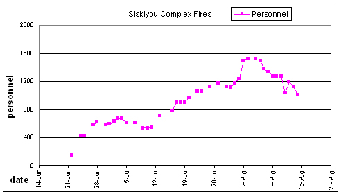
Total Personnel: 279
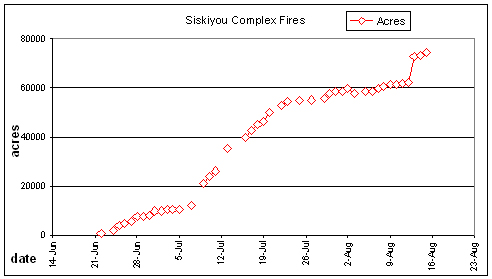
Size: 82,186 acres
Percent Contained: 95%
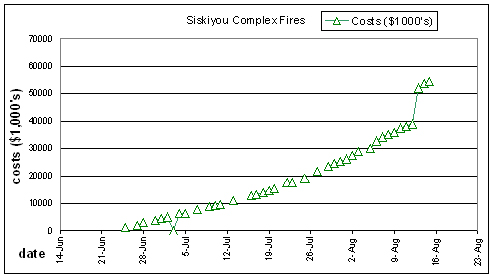
Costs to Date: $65,692,836
The fire grew another 860 acres. Direct attack on hot spots NW of Little Medicine Mountain with helicopter support continued.
FIRE FIGHTER FATALITY
The dozer operator injured late afternoon 9/5/2008 succumbed to his injuries yesterday (9/11/2008). Accident investigation team is in place.
***************
Situation as of 09/11/08 6:00 PM
Total Personnel: 284
Size: 81,356 acres
Percent Contained: 95%
Costs to Date: $65,293,810
The fire grew another 1,000+ acres. Direct attack on hot spots NW of Little Medicine Mountain with helicopter support continued.
***************
Situation as of 09/09/08 6:00 PM
Total Personnel: 293
Size: 80,562 acres
Percent Contained: 95%
Costs to Date: $64,824,706 (Cost reported today includes audit corrections that reduced total costs to date.)
The fire grew another 300+ acres. Initiated direct attack on hot spots NW of Little Medicine Mountain with helicopter support.
Dozer extraction successful.
***************
Situation as of 09/09/08 6:00 AM
Total Personnel: 293
Size: 80,280 acres
Percent Contained: 95%
Costs to Date: not reported, est. $65.5 million
The fire grew another 200+ acres. Another $500,000 was spent. Backing fire behavior with occasional small uphill runs, single tree torching in Blue Creek Drainage. Helicopter bucket drops used on hot spots NW of Little Medicine Mountain.
Forest Engineer assisted in planning for dozer extraction. Operations to extract dozer that rolled down into the canyon going well and should be completed tomorrow.
***************
Situation as of 09/07/08 6:00 PM
Total Personnel: 296
Size: 80,067 acres
Percent Contained: 95%
Costs to Date: $64,910,194
The fire grew another 400+ acres. Another $400,000 was spent. Flanking fire behavior with occasional small uphill runs and some torching in Blue Creek Drainge.
This fire could have been extinguished months ago, but the choice made by Klamath NF Supervisor Patricia Grantham was to burn baby burn all summer long. She spent our money incinerating our forests. Resources have been damaged, people have been hurt.
This fire is not about saving communities or homes. It is not about brave lads fighting the flames. It is about incineration, pure and simple. It is an obscenity.
***************
Situation as of 09/06/08 6:00 PM
Total Personnel: 270
Size: 79,635 acres
Percent Contained: 95%
Costs to Date: $64,510,284
The fire grew another 200 acres. Another $600,000 was spent. Helicopters dropped water on hot spots off Lonesome Ridge and east of Blue Creek near Elk Valley. A dozer operator was injured in an equipment roll-over late yesterday afternoon. Not word yet on the extent of the injuries suffered.
This fire could have been extinguished months ago, but the choice made by Klamath NF Supervisor Patricia Grantham was to burn baby burn all summer long. She spent our money like water incinerating our forests. Resources have been damaged, people have been hurt.
This fire is not about saving communities or homes. It is not about brave lads fighting the flames. It is about incineration, pure and simple. It is about killing forests in the name of politics for reasons of insanity by total morons.
***************
Situation as of 09/05/08 6:00 PM
Total Personnel: 266
Size: 79,431 acres
Percent Contained: 95%
Costs to Date: $63,808,637
Red Flag Warning extended through 11:00 a.m. Saturday.
The fire continues to burn into interior unburned pockets. Continuing to use helicopter bucket drops on hot spots that show up near fireline. Increased activity in Blue Creek drainage NE of Blue Creek and Crescent Creek Fork confluence. Heavy smoke in canyon. Occasional torching and short uphill runs.
***************
Situation as of 09/03/08 6:00 PM
Total Personnel: 309
Size: 78,591 acres
Percent Contained: 95%
Costs to Date: not reported, est. $63,570,796
Red Flag Warning for Wednesday evening to Friday 1100 issued by Medford and Eureka NWS with high temperatures, low daytime relative humidity, poor humidity recovery and strong NE winds.
The fire continues to burn into interior unburned pockets. Continuing to use helicopter bucket drops on hot spots that show up near fireline. Increased activity in Blue Creek drainage NE of Blue Creek and Crescent Creek Fork confluence. Heavy smoke in canyon. Some active surface fire with occasional snag burning.
***************
Situation as of 09/02/08 6:30 PM
Total Personnel: 405
Size: 78,384 acres
Percent Contained: 95%
Costs to Date: not reported, est. $63.2 million
FLIR infrared flight mapped hot spots near confluence of Blue Creek and Crescent City Fork. IMT3 Bowers took over command at 0600. Key overhead resources from IMT2 Paul extended to IMT3 Bowers following transition for operational continuity. The Fire continues to back into interior unburned pockets.
***************
Situation as of 08/31/08 6:00 PM
Total Personnel: 431
Size: 78,384 acres
Percent Contained: 95%
Costs to Date: $62,494,396
Increased acres was from fire backing into interior unburned pockets within the Blue Creek drainage and did not result in changes to containment line. IMT2 Paul will transition with IMT3 Bowers on Monday, the 1st of September.
***************
Situation as of 08/30/08 6:00 PM
Total Personnel: 488
Size: 78,369 acres
Percent Contained: 93%
Costs to Date: $61,985,726
No explanation for cost reduction.
***************
Situation as of 08/29/08 6:00 PM
Total Personnel: 544
Size: 78,188 acres
Percent Contained: 91%
Costs to Date: $62,135,222
Isolated interior minor surface fire spread, continued smoldering in isolated heavy fuels.
***************
Situation as of 08/27/08 7:30 PM
Total Personnel: 548
Size: 78,186 acres (no update)
Percent Contained: 87%
Costs to Date: not reported, est. $60.5 million
Red Flag Warnings for a large area W of the Sierra/Cascade crest through the valley and into parts of the Coastal Range. Temperatures will be about 10 deg warmer than normal during much of this time, along with daytime humidities of 8-15% across most areas. Poor nighttime RH recoveries expected as well, with some of the deeper Sierra canyons getting nighttime winds of 30-50 mph.
***************
Situation as of 08/26/08 7:30 PM
Total Personnel: 609
Size: 78,186 acres
Percent Contained: 85%
Costs to Date: not reported, est. $60 million
Reported acres decreased by 1,582 due to increased accuracy using radiometric mapping technology.
Isolated pockets of smoldering ground fire observed with continued consumption of heavy fuels.
***************
Situation as of 08/24/08 6:00 PM
Total Personnel: 567
Size: 79,768 acres (no breakdown reported)
Percent Contained: 78%
Costs to Date: $58,695,429 (no breakdown reported)
Adjustments to the resource database are still being made from combining complexes.
***************
Situation as of 08/22/08 6:00 AM
Total Personnel: 669
Size: 79,762 acres (Siskiyou 67,404 acs, Blue 2 12,358 acs) no update
Percent Contained: 78%
Costs to Date: $57,889,383 (Siskiyou $43,825,365, Blue 2 $14,064,018) no update
Nothing to report. [sic]
***************
Situation as of 08/21/08 6:00 AM
Total Personnel: 495
Size: 79,762 acres (Siskiyou 67,404 acs, Blue 2 12,358 acs)
Percent Contained: 76%
Costs to Date: $57,889,383 (Siskiyou $43,825,365, Blue 2 $14,064,018)
Backburning operations have stopped, even though the strategy to incinerate 88,150 acres (see 7/13) has not been achieved. The estimated containment date of 8/14 has not been achieved either. Fire managers will have spent $60 million before they are done catastrophically destroying the Klamath National Forest, however. So there’s that.
***************
Situation as of 08/19/08 6:00 PM
Total Personnel: 539
Size: 79,762 acres (Siskiyou 67,404 acs, Blue 2 12,358 acs)
Percent Contained: 75%
Costs to Date: $57,889,383 (Siskiyou $43,825,365, Blue 2 $14,064,018)
Crews on Division F of Siskiyou have completed firing operations to Blue Creek. Direct operations up the Crescent City Fork of Blue Creek started in Division J/K with crews cold trailing and mopping the fire edge.
***************
Situation as of 08/18/08 6:00 PM
Total Personnel: 617
Size: 79,272 acres (Siskiyou 67,017 acs, Blue 2 12,255 acs)
Percent Contained: 74%
Costs to Date: $57,436,350 (Siskiyou $43,542,000, Blue 2 $13,894,350)
Spending a $million per day as fires increase 2,000 acs per day. Accomplishing nothing but incinerated forest. Klamath NF Forest Supervisor Patricia Grantham, The Mad Woman of the Klamath, hates forests and seeks to destroy them at huge expense to the taxpayer/owners. In two months, she has killed 125 square miles of forest at a cost of nearly $60 million.
***************
Situation as of 08/17/08 6:00 PM
Total Personnel: 708
Size: 77,325 acres (Siskiyou 65,717 acs, Blue 2 11,608 acs)
Percent Contained: 72%
Costs to Date: $56,553,000 (Siskiyou $42,928,000, Blue 2 $13,625,000)
Crews will continue to secure indirect line to the confluence of Blue Creek and Crescent City Fork on the Blue Fire. Suppression repair operations on the north side of the Siskiyou Fire will continue.
Responsible official: Klamath NF Forest Supervisor Patricia Grantham
Phone Number: (530) 842-6131
***************
Situation as of 08/16/08 6:00 PM
Total Personnel: 916
Size: 75,869 acres (Siskiyou 64,755 acs, Blue 2 11,114 acs)
Percent Contained: 72%
Costs to Date: $55,433,000 (Siskiyou $42,293,000, Blue 2 $13,140,000)
Responsible official: Klamath NF Forest Supervisor Patricia Grantham
Phone Number: (530) 842-6131
***************
Situation as of 08/15/08 6:00 PM
Total Personnel: 1,005
Size: 74,410 acres (Siskiyou 63,694 acs, Blue 2 10,331 acs)
Percent Contained: 72%
Costs to Date: $54,469,582 (Siskiyou $41,517,000, Blue 2 $12,952,000)
Crews continued to monitor fire progression in the Crescent City Creek drainage.
Backing and Flanking fire. Single tree and occasional group tree torching with active backing where crews are performing firing operations. Crews will continue firing the handline into Blue Creek.

***************
Situation as of 08/14/08 6:00 PM
Total Personnel: 1,121
Size: 73,438 acres
Percent Contained: 72%
Costs to Date: $53,489,000
The Blue 2 Fire has now been re-incorporated into the Siskiyou Complex. Crews continued to monitor fire progression in the Crescent City Creek drainage.
Crews will continue firing the handline into Blue Creek. The Bluff Creek Contingency Group will continue building handline from the 13N01 Road to Lookout Point.
***************
Situation as of 08/13/08 7:00 PM
Total Personnel: 1,190
Size: 72,571 acres
Percent Contained: 72%
Costs to Date: not reported, est. $52 million
The Blue 2 Fire has now been re-incorporated into the Siskiyou Complex.
***************
Situation as of 08/12/08 6:00 PM
Total Personnel: 1,042
Size: 62,361 acres
Percent Contained: 69%
Costs to Date: $39,050,000
Firing operations continue to the west of Nickowitz Peak into Blue Creek. Crews are continuing handline construction from Road 13N01 to Lookout Point. All equipment assigned to the Bluff Creek Contingency division will decontaminate at the Port Orford Cedar wash stations.
***************
Situation as of 08/11/08 6:00 PM
Total Personnel: 1,274
Size: 61,763 acres
Percent Contained: 69%
Costs to Date: $38,261,000
Firing operations continued west of Nickowitz Peak into Blue Creek. Dozer and mastication work on the Bluff Creek contingency line is completed, and crews are now beginning handline from Road 13N01 to Lookout Point.
***************
Situation as of 08/10/08 6:00 PM
Total Personnel: 1,274
Size: 61,404 acres
Percent Contained: 64%
Costs to Date: $37,485,000
Crews continued burnout operations west of Nickowitz Peak into Blue Creek. Aerial firing will continue on the ridgeline east of Cresent City Fork Creek. Operations continued to strengthen line south of Chimney Rock. Work continues on the Bluff Creek contingency line.
***************
Situation as of 08/09/08 6:00 PM
Total Personnel: 1,274
Size: 61,344 acres
Percent Contained: 64%
Costs to Date: $36,133,000
Crews monitored the fire for opportunities to continue the burnout operation into Blue Creek. Work on the Bluff Creek contingency line continued.
***************
Situation as of 08/08/08 6:00 PM
Total Personnel: 1,328
Size: 60,777 acres
Percent Contained: 64%
Costs to Date: $35,140,000
Firing operations were hampered in Div. F due to higher relative humidities. Hand line, and a hose lay was completed into Blue Creek. Helispot construction was completed in Div. P.
***************
Situation as of 08/07/08 6:00 PM
Total Personnel: 1,380
Size: 59,820 acres
Percent Contained: 64%
Costs to Date: $34,186,000
Crews continued line construction and burnout south of Blue Creek in Div. F. Crews continued to scout potential line location between Chimney Rock on Sawtooth Mountain. Bluff Creek Contingency set up a wash station for Port Orford Cedar decontamination.
73 total miles of line are now planned for the Siskiyou / Blue 2 Fires. 67 of these miles have been completed.
***************
Situation as of 08/06/08 6:00 PM
Total Personnel: 1,492
Size: 58,766 acres
Percent Contained: 64%
Costs to Date: $32,870,000
***************
Situation as of 08/06/08 8:00 AM
Total Personnel: 1,520
Size: 58,335 acres
Percent Contained: 63%
Costs to Date: $30,225,000
Red Flag Warning for thunderstorms accompanied by little or no precipitation. Warning in effect from midnight Tuesday night until noon on Wednesday.
***************
Situation as of 08/03/08 6:00 PM
Total Personnel: 1,522
Size: 57,785 acres
Percent Contained: 60%
Costs to Date: $28,789,000
Acreage decrease from 0600 report due to better mapping. Held line, and deepened burning in Div. E and F. Continued burning in Div. O.
***************
Situation as of 08/02/08 6:00 PM
Total Personnel: 1,492
Size: 59,678 acres
Percent Contained: 60%
Costs to Date: $27,486,477
Percent containment based on Blue and Siskiyou being managed under one containment strategy. Costs are still calculated seperately by incident. For the Blue/Siskiyou Fire 60%(45 miles) of the total planned line (75 miles) has been completed, with 30 miles (40%) remaining to be completed. An IMT transition is scheduled to occur on 8/2 with tentative transfer of command on Sunday 8/3 at 0600.
***************
Situation as of 08/01/08 6:00 PM
Total Personnel: 1,235
Size: 58,657 acres
Percent Contained: 52%
Costs to Date: $26,301,252
An IMT transition is scheduled to occur on 8/2 with tentative transfer of command on Sunday 8/3 at 0600.
Percent containment based on Blue and Siskiyou being managed under one containment strategy. Costs are still calculated separately by incident. For the Blue/Siskiyou Fire 52%(39 miles) of the total planned line (75 miles) has been completed, with 36 miles (48%) remaining to be completed.
***************
Situation as of 07/31/08 6:00 PM
Total Personnel: 1,178
Size: 58,456 acres
Percent Contained: 46%
Costs to Date: $25,375,550
***************
Situation as of 07/30/08 6:00 PM
Total Personnel: 1,110
Size: 57,855 acres
Percent Contained: 46%
Costs to Date: $24,852,972
***************
Situation as of 07/29/08 6:00 PM
Total Personnel: 1,121
Size: 55,872 acres
Percent Contained: 46%
Costs to Date: $23,460,271
Continued firing operations west on Lonesome Ridge and strengthening of southwest lines. Single and group tree torching.
***************
Situation as of 07/27/08 6:00 PM
Total Personnel: 1,181
Size: 55,084 acres
Percent Contained: 42%
Costs to Date: $21,712,168
No report on Blue 2 Fire.
***************
Situation as of 07/25/08 6:00 AM
Total Personnel: 1,120
Size: 54,657 acres
Percent Contained: 36%
Costs to Date: $19,104,543
***************
Situation as of 07/23/08 6:00 AM
Total Personnel: 1,056
Size: 54,559 acres
Percent Contained: 36%
Costs to Date: $17,425,741 reported, no explanation for reduction in costs
1 new fire discovered north of main fire. No name or size reported.
Transition to command of Blue 2 fire is in progress. The Blue Fire began as its own fire, then became part of the Orleans/Ukonom Complex, then became its own fire again as the Blue 2 Fire, and now it will be incorporated into the Siskiyou Complex. We will continue to track it, if we can sort out the musical fires game.
***************
Situation as of 07/22/08 6:00 PM
Total Personnel: 1,056
Size: 52,800 acres
Percent Contained: 36%
Costs to Date: $17,434,614
***************
Situation as of 07/20/08 6:00 PM
Total Personnel: 970
Size: 50,000 acres
Percent Contained: 29%
Costs to Date: $15,600,000
Firing operations are progressing along the dozer line on Beans Ridge, above the Klamath River and within the interior. Arial ignition is being utilized.
***************
Situation as of 07/19/08 6:00 AM
Total Personnel: 896
Size: 46,600 acres
Percent Contained: 20%
Costs to Date: not updated, est. $15 million
***************
Situation as of 07/18/08 6:00 PM
Total Personnel: 896
Size: 45,100 acres
Percent Contained: 20%
Costs to Date: $14,100,000
***************
Situation as of 07/17/08 6:00 PM
Total Personnel: 893
Size: 42,900 acres
Percent Contained: 20%
Costs to Date: $13,300,000
Estimated Containment Date: 08/14/08
***************
Situation as of 07/16/08 6:00 PM
Total Personnel: 782
Size: 39,750 acres
Percent Contained: 18%
Costs to Date: $12,700,000
Critical shortage of resources to meet the needs for the current strategy, which is to burn 90,000 acres. More backfiring crews needed, aerial torch helicopters, napalm, etc.
Restrictions have been placed on rafting access in the Klamath River in the fire area. No report on the miles of endangered salmon spawning tributaries to be incinerated under Long Term Strategy.
***************
Situation as of 07/13/08 6:00 PM
Total Personnel: 710
Size: 35,400 acres
Percent Contained: 16%
Costs to Date: $10,900,000
Estimated Containment Date: 08/14/08
Old “large fire strategy” of 40,000 acres now abandoned. New strategy is 88,150 projected acres. This plan goes west on Lonesome Ridge Road to the confluence of the East Fork of Blue Creek and Blue Creek.
***************
Situation as of 07/11/08 6:00 PM
Total Personnel: 540
Size: 26,200 acres
Percent Contained: 34%
Costs to Date: $9,670,000
Very active fire behavior occurred, especially in areas in alignment with wind and slope. Uphill runs, torching and some long range spotting. Early afternoon shift in wind direction caused an increase in fire behavior on the NW flank.
***************
Situation as of 07/10/08 6:00 PM
Total Personnel: 529
Size: 24,000 acres
Percent Contained: 34%
Costs to Date: $9,220,000
***************
Situation as of 07/09/08 6:00 PM
Total Personnel: 529
Size: 21,200 acres
Percent Contained: 34%
Costs to Date: $8,830,000
Dark-Three (now merged with Jackass Too) at 20,653 acres 34% contained, Headwaters at 547 acres 0% contained.
As per regional direction, the Headwaters fire is converted from WFU to Suppression Fire to be managed with AMR (appropriate management response). Est Containment date: 08/14/2008. [How is this different? Now they can pretend to fight the fire and avoid any NEPA concerns. By any other name Let It Burn is still Let It Burn. - Ed]
***************
Situation as of 07/07/08 6:00 PM
Total Personnel: 615
Size: 12,270 acres
Percent Contained: 35%
Costs to Date: $7,800,000
Est containment date: 08/15/2008. Est containment acreage: 40,000 acres. Est containment costs: $35 million.
***************
Situation as of 07/05/08 6:00 PM
Total Personnel: 614
Size: 10,665 acres
Percent Contained: 29%
Costs to Date: $6,342,582
ORCA IMT 2 (Paul) is transitioning with N. Cal Team 1 (Swartzlander). ORCA IMT 2 has been on the The Siskiyou Complex since 6/24.
***************
Situation as of 07/04/08 6:00 PM
Total Personnel: 667
Size: 10,665 acres
Percent Contained: 27%
Costs to Date: $6,157,610
Actions: continuing to implement large strategy encompassing approximately 40,000 acres to be burned.
***************
Situation as of 07/03/08 6:00 PM
Total Personnel: 668
Size: 10,515 acres
Percent Contained: 25%
Costs to Date: NO REPORT, est $5.6 million
Overhead Team Name: Ken Paul Organization: Type 2 Team
No reported progress in containing fires. 2 of 3 fires have 0 containment despite 2 weeks effort and more than $5 million expended.
***************
Situation as of 07/02/08 6:00 PM
Total Personnel: 627
Size: 9,915 acres
Percent Contained: 25%
Costs to Date: $4,987,754
Planned Actions: Continue burn out on Dark Three Fires, monitor Jackass Too and Headwater WFU.
***************
Situation as of 07/01/08 6:00 PM
Total Personnel: 589
Size: 9,915 acres
Percent Contained: 25%
Costs to Date: $4,473,065
South end of Dark-Three is becoming secure. Actions continuing up east line with burnout as needed and prep is continuing up the west line as well as across trail system in the north. 7 days to complete line on outer large strategy that would encompass approximately 40,000 acres.
Current strategy is to merge all of the fires together over a 40,000 acre (62,5 sq mile) area. No cost estimate of this strategy was reported.
Currently Dark-Three Fire 9,120 Acres, 25% containment.Jackass Too Fire 248 Acres, 0% containment. Headwaters Fire 547 Acres, 0 % containment.
***************
Situation as of 06/30/08 6:00 PM
Total Personnel: 582
Size: 7,988 acres
Percent Contained: 23%
Costs to Date: $3,984,817
Dark-Three 7,415 acs, 60%. Jackass Too 252 acs, 0%. Headwaters 321 acs, 0%.
***************
Situation as of 06/29/08 11:00 PM
Total Personnel: 622?
Size: 7,725 acres
Percent Contained: 20%
***************
Situation as of 06/28/08 6:00 PM
Total Personnel: 622
Size: 7,570 acres
Percent Contained: 15%
Costs to Date: $2,973,983
Dillon Creek Campground and 1 residence remain threatened due to increased fire intensity and potential for downhill spread. Priority for suppression activities remain with the Dark Three fires and threat to structures. Total acres 7570, Headwaters ~320 acres, Jackass Too ~250 acres.
***************
Situation as of 06/27/08 6:00 PM
Total Personnel: 581
Size: 5,600 acres
Percent Contained: 15%
Costs to Date: $2,018,912
Dillon Creek Campground,Dillon Creek Trail;and roads 14N69, 13N69, 13N35, 14N21, 14N19, 14N38, and Hwy 96 are closed.
***************
Situation as of 06/27/08 8:00 AM
Total Personnel: 580
Size: 5,000 acres
Percent Contained: 12%
***************
Situation as of 06/25/08 6:00 PM
Total Personnel: 428
Size: 4,000 acres
Percent Contained: 8%
Costs to Date: $1,226,785
Structures Threatened: 2 PRIM , 1 OUTB Structures Destroyed: NONE
Dillon Creek Campground is closed and threatened due to proximity of the fire, road closures in the area are likely. Hwy 96 will probably be closed starting 6/26/2008.
Dark-Three Fire, Jackass Too Fire, Headwater WFU Fire. Mill Fire absorbed into Dark-Three.
[Look, look. Funny names and a whoofoo. These jokers plan to milk these fires until November. Rack up $50 million to be spent burning the KNF. Just a suggestion, Ken, how about containing, controlling, and extinguishing the fires, hey? - editorial comment]
***************
Situation as of 06/24/08 10:00 PM
Total Personnel: 428
Size: 2,000 acres
Percent Contained: 0%
Type 2 IMT (Paul) committed. Need air support, helicopters, tankers. Steep, inaccessable terain,fires are well established and due to access, fuels, topography will have significant growth over an extended timeframe before containment/control can be achieved. Air support and type 1 crews are essential to any success.
***************
Situation as of 06/22/08 5:30 PM
Total Personnel: 146
Size: 500 acres
Percent Contained: 0%
Type 2 team taking over fire at 1900
InciWeb has been dysfunctional on and off for two weeks or more. The spate of fires has overloaded all the govt sites.
Here is what we heard: the SRF Lightning Complex Fires, Klamath NF, Shasta Trinity NF, Salmon River area, is 1,000+ acres, multiple starts, many unstaffed. Fires include the Travis, Blue, Jake Allgood, Sims and Packsaddle Fires.
At last report there were 17 fire personnel on these fires, which is ridiculously few, and must be considered a typo of some kind in the official report. There has been no update since Sunday.
The coordinates given are Latitude: 41° 2´ 37″, Longitude: 123° 23´ 2″, but since there are multiple fires, those might not be accurate.
The Trinity Alps Wilderness may or may not be officially closed. It is probably a good idea not to venture out there right now.
We are checking the govt sites hourly, and will update when we hear something new.
by jen
try this site
http://atlas.resources.ca.gov/OES/default.aspx
you can zoom way in to the Salmon. the streams and roads aren’t labelled, so have a map handy if you don’t know the area by heart. if you don’t know what the colors mean, expand the map contents. good luck

I am looking for any information about the fires around the Salmon River. There is nothing I can find on the web, and the INCI site does not open, nor much of anything else about fires in this area. Where do I go?