Orleans/Ukonom Complex Fires
Location: 3 mi SW Somes Bar, Salmon River area, Six Rivers NF, Humboldt Co., CA
Specific Location: Lat 41° 21´ 17″ Lon 123° 32´ 11″
Date of Origin: 06/21/08
Cause: Lightning
Situation as of 09/10/08 6:00 PM
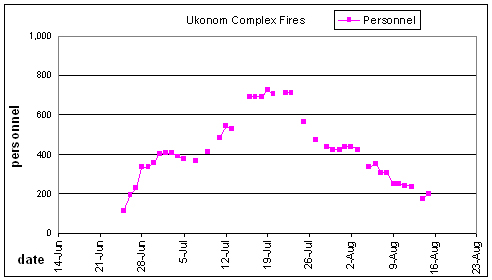
Total Personnel: 279
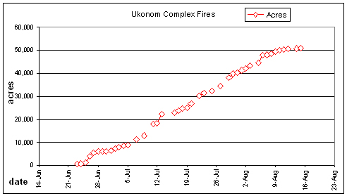
Size: ~60,500 acres (it is impossible to determine because the Ukonom Fire has been split in two and then combined with the Bear Wallow and Panther Fires. A whole lot of number juggling has gone on with the Klamath NF fire reports.)
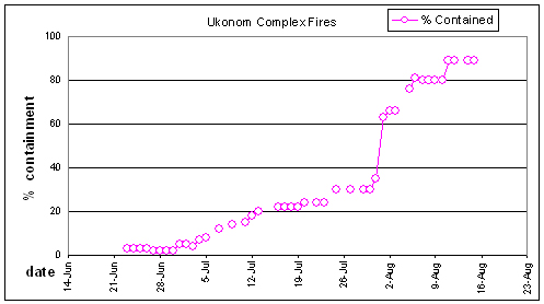
Percent Contained: 75% reported (despite the massive spending that has gone on, no gain in containment has been achieved for weeks)
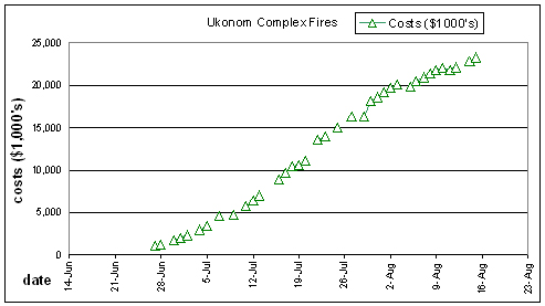
Costs to Date: not reported, est. $30 million ???
Addition 500 acres incinerated yesterday. Fire progressed north of the Little North Fork of the Salmon River towards English Peak and the Uncles Fire of 2006. More deliberate backburning occurring today.
Three month old fire still expanding. Talk about your crappy fire suppression! There has never any attempt to suppress this fire. All actions taken over the last 3 months have been to expand it. Tremendous graft and drainage of taxpayer coffers into the hands of pirates and profiteers who destroy forests for a living.
Nearly 3 months of this fire and it is still killing forests, still uncontained, still expanding, still costing hundreds of thousands of dollars a day.
***************
Situation as of 09/09/08 6:00 PM
Total Personnel: 185?
Size: ~60,000 acres (it is impossible to determine because the Ukonom Fire has been split in two and then combined with the Bear Wallow and Panther Fires. A whole lot of number juggling has gone on with the Klamath NF fire reports)
Percent Contained: ??% (despite the massive spending that has gone on, no gain in containment has been achieved for weeks)
Costs to Date: not reported, est. $28 million ???
Fire progression north of the Little North Fork of the Salmon River near English Peak progressed rapidly to the E. Three month old fire still expanding. Talk about your crappy fire suppression! There was never any attempt to suppress this fire. All actions taken over the last 3 months have been to expand it.
Nearly 3 months of this fire and it is still killing forest, still uncontained, still expanding, costing hundreds of thousands of dollars a day.
***************
Situation as of 09/07/08 6:00 PM
Total Personnel: not reported
Size: ~56,000 acres (it is impossible to determine because the Ukonom Fire has been split in two and then combined with the Bear Wallow and Panther Fires. A whole lot of number juggling has gone on with the Klamath NF fire reports)
Percent Contained: 82% (despite the massive spending that has gone on, no gain in containment has been achieved for weeks)
Costs to Date: not reported, est. $28 million
The fire continues to back and flank out of some larger runs that developed yesterday. Almost all of the fire activity is in timber fuels [aka forest] with occasional torching and group torching when flanking fire is capable of making uphill runs. The main fire activity is between Yellow Jacket Ridge and English Peak and between Ukonom Lake and Bridge Creek.
Nearly three months of this fire and it is still killing forest, still uncontained, still costing hundreds of thousands of dollars a day.
The Ukonom Fire is a travesty. Six Rivers NF Supervisor Tyrone Kelley is a stone cold forest killer.
***************
Situation as of 09/02/08 7:30 PM
Total Personnel: not reported
Size: 52,908 acres (no update)
Percent Contained: 82%
Costs to Date: not reported, est. $27.5 million
Increased fire activity with most of the fire spread still a slow backing fire with some flanking and small uphill runs. Heavy down fuels are burning intensely with torching and occasional group torching. The main fire activity is between Ukonom Lake and Bridge Creek and between Yellow Jacket Ridge and English Peak within the Marble Mountain Wilderness.
***************
Situation as of 09/02/08 7:30 PM
Total Personnel: not reported
Size: 52,908 acres (no update)
Percent Contained: 82%
Costs to Date: not reported, est. $26.5 million
The fire is backing slowly in timber fuels with occasional torching. Rollout on steep slopes is causing small uphill runs. In sparser fuels the fire is creeping through large dead and down fuels. The main fire activity is between Ukonom Lake and Medicine Mountain and in the area North of Yellow Jacket Ridge.
***************
Situation as of 08/27/08 7:30 PM
Total Personnel: not reported
Size: 52,908 acres (no update)
Percent Contained: 82%
Costs to Date: not reported, est. $25.5 million
Preparing for Fire Weather Watch (gusty winds and low RH) from 2300 hours tonight through 1100 hours August 29. Active burning in Wooley Creek and Crapo Mountain area of the Uknonom Fire.
***************
Situation as of 08/24/08 6:00 AM
Total Personnel: 102
Size: 52,908 acres (north 23,154, south 29,754)
Percent Contained: 82%
Costs to Date: est. $25 million
Ukonom acres adjusted down. Costs no longer being reported.
***************
Situation as of 08/22/08 6:00 PM
Total Personnel: 132
Size: 52,945 acres (north 23,154, south 29,791)
Percent Contained: 82%
Costs to Date: est. $25 million
***************
Situation as of 08/19/08 6:00 PM
Total Personnel: 132
Size: 52,884 acres (north 23,154, south 29,730)
Percent Contained: 75%
Costs to Date: est. $24.5 million
***************
Situation as of 08/17/08 6:00 PM
Total Personnel: 163
Size: 52,385 acres (north 23,058, south 29,327)
Percent Contained: 82%
Costs to Date: $23,679,700
Much number juggling going on, difficult to sort out.
***************
Situation as of 08/17/08 6:00 PM
Total Personnel: not reported
Size: 51,393 acres (north 22,066, south 29,327)
Percent Contained: 82%
Costs to Date: $23,660,900
Responsible official: Six Rivers NF Forest Supervisor Tyrone Kelley
Phone Number: (707) 442-1721
***************
Situation as of 08/16/08 6:00 PM
Total Personnel: 174
Size: 51,393 acres (north 22,066, south 29,327)
Percent Contained: 82%
Costs to Date: $23,528,500
Responsible official: Six Rivers NF Forest Supervisor Tyrone Kelley
Phone Number: (707) 442-1721
***************
Situation as of 08/15/08 6:00 PM
Total Personnel: 198
Size: 51,017 acres
Percent Contained: 89%
Costs to Date: $23,272,000
Tomorrow the north half of the Ukonom Fire will be transferred to the Harvey IMT2 which is managing the Panther Fire.
3 historic cabins and a lookout are now threatened by backfires.
Smoldering and creeping with isolated torching and active backing where crews are performing firing operations.
***************
Situation as of 08/14/08 6:00 PM
Total Personnel: 176
Size: 50,721 acres
Percent Contained: 89%
Costs to Date: $22,862,000
Crews started firing operations from Crapo Mountain bringing fire down the Little North Fork River.
***************
Situation as of 08/12/08 6:00 PM
Total Personnel: 235
Size: 50,425 acres
Percent Contained: 89%
Costs to Date: $22,097,000
54 total miles of line are now planned for the Ukonom Fire. 54 of these miles have been completed. If conditions are favorable, crews will commence firing operations from Crapo Mountain northeast towards the Uncles Fire.
***************
Situation as of 08/11/08 6:00 PM
Total Personnel: 240
Size: 50,183 acres
Percent Contained: 89%
Costs to Date: $21,806,000
Unexplained reduction in costs. Haypress Spike has closed. Crews and overhead haved moved back to Orleans ICP. Division BB and CC are in monitor status. Line from Crapo Mountain to DP148 is completed and is being prepped for burning. Work continues from DP U148 towards Uncles fire.
***************
Situation as of 08/10/08 6:00 PM
Total Personnel: 248
Size: 49,929 acres
Percent Contained: 80%
Costs to Date: $22,022,000
54 total miles of line are now planned for the Ukonom Fire. 51 of these miles have been completed.
***************
Situation as of 08/09/08 6:00 PM
Total Personnel: 248
Size: 49,591 acres
Percent Contained: 80%
Costs to Date: $21,756,000
Crews continued line construction on Yellowjacket Ridge towards the Little North Fork of the Salmon River. Patrol and mop up continued in the Forks and Salmon River Road area. Excess equipment and resources from the Forks Base Camp are being reassigned within the complexes.
***************
Situation as of 08/08/08 6:00 PM
Total Personnel: 307
Size: 48,634 acres
Percent Contained: 80%
Costs to Date: $21,420,000
Burnout operations have succeeded in joining the Ukonom and Panther Fires. Crews have begun line construction on Yellowjacket Ridge towards the Little North Fork of the Salmon River.
***************
Situation as of 08/07/08 6:00 PM
Total Personnel: 308
Size: 48,012 acres
Percent Contained: 80%
Costs to Date: $21,008,000
Crews are mopping up and securing line from yesterdays burnout between Haypress Spike Camp and the Panther Fire. Crews continued to mop up in the Forks area. Increased activity in yesterdays slopover between Yellowjacket Ridge and Clear lake has caused firefighters to reevaluate line location in this area.
54 total miles of line are now planned for the Ukonom Fire. 48 of these miles have been completed. The E flank of the Ukonom fire is being managed under a confinement strategy, and is not included in the percent containment calculations.
***************
Situation as of 08/06/08 6:00 PM
Total Personnel: 354
Size: 47,728 acres
Percent Contained: 81%
Costs to Date: $20,560,000
A slop over occurred on the line between Yellowjacket Ridge and Clear Lake. This slop over is not yet contained, and is causing a re-evaluation of line location in this area.
Moderate fire behavior with torching and spotting. Backing and flanking fire, with 1/2 mile uphill runs in stringers of heavy timber.
***************
Situation as of 08/06/08 8:00 AM
Total Personnel: 336
Size: 44,475 acres
Percent Contained: 76%
Costs to Date: $19,850,000
Ukonom costs decreased when equipment was changed to a monthly rate, and duplicate fixed wing costs were eliminated.
Red Flag Warning for thunderstorms accompanied by little or no precipitation. Warning in effect from midnight Tuesday night until noon on Wednesday.
***************
Situation as of 08/03/08 6:00 PM
Total Personnel: 424
Size: 43,390 acres
Percent Contained: 66%
Costs to Date: $20,072,000
Transfer of command from Dietrich’s IMT to Wilcock’s IMT occurred on Sunday 8/3 at 0600. Type 2IA Crews = 4
***************
Situation as of 08/02/08 6:00 PM
Total Personnel: 438
Size: 42,195 acres
Percent Contained: 66%
Costs to Date: $19,690,004
Continued line construction in anticipation of burnout north of Ahlgrens Cabin.
***************
Situation as of 08/01/08 6:00 PM
Total Personnel: 440
Size: 41,372 acres
Percent Contained: 63%
Costs to Date: $19,190,943
Continued line preparation, and burned out to support control lines above Salmon River near Forks.
For the Ukonom Complex, 63% (36 miles) of the total planned line (57 miles) has been completed, with 21 miles (27%) remaining to complete; 11 miles (16% of total) has a confinement strategy and cannot be shown as planned containment.
***************
Situation as of 07/31/08 6:00 PM
Total Personnel: 422
Size: 40,250 acres
Percent Contained: 35%
Costs to Date: $18,667,546
Pack trains (mules) to support the Haypress and Ahlgens Spike Camps.
***************
Situation as of 07/30/08 6:00 PM
Total Personnel: 422
Size: 39,840 acres
Percent Contained: 30%
Costs to Date: $18,153,384
***************
Situation as of 07/29/08 6:00 PM
Total Personnel: 440
Size: 38,089 acres
Percent Contained: 30%
Costs to Date: $16,340,920
Est date of containment: 09/15/2008
Road closures still in effect. Continued burnout near Haypress Mountain.
***************
Situation as of 07/27/08 6:00 PM
Total Personnel: 474
Size: 34,466 acres
Percent Contained: 30%
Costs to Date: $16,340,920
Voluntary evacuation notice for Forks of the Salmon to Nordheimer Road and in the Pollacks subdivision along North Fork Salmon Road.
***************
Situation as of 07/25/08 6:00 PM
Total Personnel: 565
Size: 32,266 acres
Percent Contained: 30%
Costs to Date: $15,029,226
***************
Situation as of 07/23/08 6:00 PM
Total Personnel: 712
Size: 31,281 acres
Percent Contained: 24%
Costs to Date: not reported, est. $14 million
Estimated Containment Date: September 15th, 2008
Increased fire activity with torching short uphill runs, frequent rollout, and aggressive persistent backing. Scattered active flare ups and occasional single tree/group torching with short range spotting. Wind aligned uphill spread with torching and fingering runs on steeper slopes is likely. Fire growth continues to the north and east on multiple flanks of the fires edge.
***************
Situation as of 07/23/08 6:00 PM
Total Personnel: 712
Size: 30,231 acres
Percent Contained: 24%
Costs to Date: $13,601,711
Since the last report the fire has expanded 5,000 acres, $3 million has been spent, and no change has been made in containment percentage.
Road closures are still in effect. A closure order is in effect for numerous Forest Service roads and trails. There is a pre-evacuation notice for Forks of the Salmon. There is a voluntary evacuation for structures in the Pollocks subdivision along the North Fork of the Salmon road.
Crews continue to monitor the fires, allegedly.
***************
Situation as of 07/20/08 6:00 PM
Total Personnel: 706
Size: 25,155 acres (not updated)
Percent Contained: 24%
Costs to Date: $11,220,287
Hot and dry weather persists. Steeper slopes and areas influenced by wind will generate accelerated spread rates and flame lengths. Single tree and group torching may be expected with spotting up to .4 miles, short-range spotting can be expected from flare-ups. Brush fuels will contribute to fire spread and intensity on steep/windy slopes, especially below 4500’. Fire growth continues to the north and east on multiple flanks of the fires edge.
***************
Situation as of 07/19/08 6:00 PM
Total Personnel: 727
Size: 25,155 acres
Percent Contained: 22%
Costs to Date: $10,637,350
Estimated Containment Date: 09/15/2008
***************
Situation as of 07/18/08 6:00 PM
Total Personnel: 695?
Size: 24,593 acres
Percent Contained: 22%
Costs to Date: not reported, est. $10.4 million
***************
Situation as of 07/17/08 6:00 PM
Total Personnel: 695
Size: 23,992 acres
Percent Contained: 22%
Costs to Date: $9,656,860
Estimated Containment Date: 09/15/2008
Hot and dry weather persists. Increased fire activity today with torching short uphill runs, frequent rollout and aggressive persistent backing. Surface fires are more active today. The probability of ignition is 90-100% so any spots produced will ignite spot fires. Fire growth continues to the north and east on multiple flanks of the fires edge.
***************
Situation as of 07/16/08 6:00 PM
Total Personnel: 691
Size: 22,926 acres
Percent Contained: 22%
Costs to Date: $8,909,706
Est containment date: 09/15/2008
Efforts in Moorehouse Creek have been abandoned due to fire crossing drainage and becoming established on west aspect. Line construction has started on SE corner near Nordheimer progressing to the NE up Yellowjacket Ridge.
***************
Situation as of 07/13/08 6:00 PM
Total Personnel: 530
Size: 22,176 acres
Percent Contained: 20%
Costs to Date: $6,977,195
Est Containment Date: 10/01/2008
***************
Situation as of 07/13/08 6:00 AM
Total Personnel: 545
Size: 18,477 acres
Percent Contained: 18%
Costs to Date: not reported, est. $7.5 million
The fire has established itself in the 1987 fire area with large amounts of dead and down material and large snag patches.
Est containment date: 10/01/2008. Est final fire size if fire burns until 10/01: 100,000+ acres. Est final fire cost if fire burns until 10/01: $50+ million.
***************
Situation as of 07/11/08 6:00 PM
Total Personnel: 486
Size: 17,847 acres
Percent Contained: 15%
Costs to Date: $5,780,936
This mornings IR map shows that all the wildfires fires have joined.
Major firing operation planned in Division M. Complete fireline along the West side of Merrill Creek, utilizing roads, dozer lines, and handlines. Continue to burn off this completed line from junction of the 12N02 and the 12N48 road north to the junction of the 12N48 and the 15N17 road if weather permits. Crews will be holding recently fired lines along the Salmon River Road, from junction of the 15N17 and the 12N02 road to the junction of the 12N02 and 12N48 road, and around Oak Bottom residences.
***************
Situation as of 07/09/08 6:00 PM
Total Personnel: 409
Size: 13,034 acres
Percent Contained: 14%
Costs to Date: $4,790,245
Est containment date: 10/01/2008.
Merrill Fire ~ 8605 acres and 31% contained; Jake Fire ~ 4429 acres and 25% contained. The Merrill and Jake fires have merged.
Surface fires are more active with isolated and group torching and spotting. Snags provide for spotting potential across the Salmon River. The probability of ignition is 88%-100% so any spots produced will ignite spot fires.
***************
Situation as of 07/07/08 6:00 PM
Total Personnel: 364 (Blue2 - 32, Unokom - 332)
Size: 11,176 acres (Blue2 - 1,150, Unokom - 10,026)
Percent Contained: 12%
Costs to Date: $4,550,000 (Blue2 - $550,000, Unokom - $4,000,000)
The Blue2 Fire (previously reported as Blue Fire) is 1,150 acres, 7% contained.
Closure order has been established for the Salmon River Road as fire imminently threatens structures.
Est containment date: 10/01/2008.
***************
Situation as of 07/05/08 6:00 PM
Total Personnel: 379
Size: 9,031 acres
Percent Contained: 8%
Costs to Date: $3,398,244
Transition of the Blue Fire to Svalberg IMT 2 will occur tomorrow at 1500.
***************
Situation as of 07/04/08 6:00 PM
Total Personnel: 388
Size: 8,492 acres
Percent Contained: 7%
Costs to Date: $3,000,000
Expected containment date: 10/01/08
***************
Situation as of 07/03/08 11:00 PM
Total Personnel: 405?
Size: 7,865 acres
Percent Contained: 4%
Expected containment date: 10/01/08
Burn baby burn. This fire represents long term employment for firefighters. No strategy to contain, control, or extinguish. Taxpayers expected to shovel money into the fire all summer long. $3 million spent already. When the fire blows up, then shovel some more. Extremely critical Native American cultural and spiritual sites to be incinerated, including the only known fully intact Karuk spiritual site. Salmon spawning endangered. No NEPA, no ESA, no NHPA, no compliance with any environmental law by rogue USFS officials.
***************
Situation as of 07/02/08 6:00 PM
Total Personnel: 405
Size: 7,244 acres
Percent Contained: 5%
Costs to Date: $2,300,000
Contained significant spots outside containment line and continued firing operations along the 15N17 road northeast of Offield Saddle. Burn out completed on the 12N07 road from East Peak to Offield Saddle. Burn out operations will serve to prevent movement of the Merrill fire towards Highway 96. Continue line construction from East Peak to the Salmon River. Assessment continues on the structures near Somes Bar and north along the Klamath River.
***************
Situation as of 07/01/08 6:00 PM
Total Personnel: 403
Size: 6,358 acres
Percent Contained: 5%
Costs to Date: $2,021,000
Burn out implemented along the 12N07 road to Offield Saddle to prevent movement of the Merrill fire towards Highway 96. Continued construction of hand line and line preperation occuring for further burn out operations along the 12N07 road.
Merrill Fire ~3715 acres and 7% contained; Jake Fire ~1982 acres and 1% contained; Blue Fire ~661 and 8% contained.
***************
Situation as of 06/30/08 6:00 PM
Total Personnel: 357
Size: 5,884 acres
Percent Contained: 2%
Costs to Date: $1,700,000
The reduction in acres for the Merrill Fire was due to IR flight which better defined the perimeter.
Merrill Fire ~3502 acres; Jake Fire ~1775 acres; Blue Fire ~607 acres. Developing Long Term Implementation Plan for the complex.
***************
Situation as of 06/29/08 11:00 PM
Total Personnel: 336?
Size: 6,256 acres
Percent Contained: 2%
When conditions permit, a burnout will be conducted, along Road 12N07, the western flank of the Merrill fire, to prevent movement towards Highway 96 corridor.
***************
Situation as of 06/28/08 6:00 PM
Total Personnel: 336
Size: 6,009 acres
Percent Contained: 2%
Costs to Date: $1,250,000
The Ukonom Complex consists of the following fires in priority order: #1 Jake Fire ~1397 acres; #2 Merrill Fire ~4,131 acres; #3 Blue Fire ~481. No acre change on the Blue Fire as IR was not completed and no other intel was received.
***************
Situation as of 06/27/08 6:00 PM
Total Personnel: 228
Size: 5,548 acres
Percent Contained: 2%
Costs to Date: $1,033,000
The Ukonom Complex now consists of the following fires in priority order: #1 Jake Fire ~ 1272 acres; #2 Merrill Fire ~ 3795 acres, #3 Blue Fire ~ 481 acres. Cost differential increase due to including Blue Fire within the Ukonom Complex. Begining devlopment of Long Term Implementation Plan. Need for crews may be influenced by the LTIP.
Planned burnout for western flank of the Merrill fire to attempt to stop westward movement towards Highway 96 corridor. Unable to take significant actions without aerial support. Helicopter support is a high priority for safety of burnout operations, assisting crews with bucket work to help hold lines of burnout. The Jake fire continues to threaten structures within the Salmon River drainage and the Merrill Fire threatens residences along Somes Bar. Merrill and Jake fires are threatening important Cultural resources and impacting fisheries. Archeologist will assist Heritage Resource Advisors in the identification of Cultural resources to protect. Wooley Creek historical cabins (used by President Hoover) are in danger in addition to private property in the area. Possibility of extensive damage to timber resources exists with significant impact to watersheds properties.
The Blue Fire will be managed by a Fire Use Module and a Division Supervisor; all resources currently assigned are being reassigned to the Merrill Fire.
***************
Situation as of 06/26/08 5:00 PM
Total Personnel: 195
Size: 4,100 acres
Percent Contained: 3%
Jake Fire: 1,051 acres. Merrill Fire: 2,788 acres. Blue Fire: 271 acres.
***************
Situation as of 06/25/08 6:00 PM
Total Personnel: 113
Size: 1,250 acres
Percent Contained: 3%
Jake and Portuguese fires have burned together and will be managed as one under the name of the Jake Fire. Jake Fire (combination of Portuguese and Jake Fires) ~985 acres; Merrill Fire ~135 acres; Blue Fire (to be reported on next 209); Mountain Fire ~130 acres; Haypress Fire.
***************
Situation as of 06/25/08 2:00 PM
Total Personnel: unknown
Size: 750 acres
Percent Contained: unknown
Now includes the Blue Fire as well as the Jake, Portugese Mountain, Haypress Mountain and Crapo Fires. The IMT is working with the Karuk tribe and local Fire Safe Community groups in the Somes Bar/Orleans and Salmon River areas.
Access on Highway 93 (Salmon River Road) is restricted from Nordheimer Campground to Wooley Creek. The Dillion Creek and Wooley Creek Campgrounds are closed.
A public meeting is scheduled at the Junction School in Somes Bar for 6:00 p.m. on Thursday, June 26.
***************
Situation as of 06/24/08 10:00 PM
Total Personnel: unknown
Size: 1,250 acres
Percent Contained: 3%
Anticipate Type 2 Team to take over at 1800. Steep terrain with roll outs causing ignitions outside containment lines. Access issues with steep terrain and heavy fuels, no natural barriers. Unable to take action without aerial support. Helicopter support is an extremely high priority for safety. Jake fire reached the Salmon River threatening structures. Mountain, Merrill and Jake fires are threatening important Cultural resources and impacting fisheries. Wooley Creek historical Cabins (used by President Hoover) are in danger and there is 16 acres of private property in this area. Timber resources and Watersheds are of concern. Assisting with the Packsaddle fire on Lower Trinity District to keep in out of Red Cap drainage.
***************
Situation as of 06/24/08 3:00 PM
Total Personnel: unknown
Size: 500 acres
Percent Contained: 3%
Type 2 IMT (Lund) committed.
by Icefire
The strategy is Let It Burn until fall rains extinguish it. That is what the October expected containment date means.
There has been no NEPA process, no Environmental Impact Statement, no Section 7 consultation under the Endangered Species Act, no Section 6 consultation under the National Historic Preservation Act, and no public involvement process. WFSA’s do not comply with those laws.
Most other fires in CA are being managed for containment and control within a few days. There is no intention of allowing other fires to burn until October. The Klamath NF (or as you suggest, the WO) has made a decision contradictory to public safety, and social and environmental values.
Many $millions will be spent NOT fighting the Ukonom fires, and many times that will be lost in environmental values. The Ukonom Complex is a major disaster in the making, similar to the Payette and Boise fires of last year.
We made the same arguments last summer during those fires, and suffered the same insults from pusillanimous federal functionaries. Yet when the 2007 season was finished over 800,000 acres of Central Idaho forests had been incinerated. That Salmon River was decimated and continues to be from ash, soot, and baked soil erosion.
The proof is on the land. The same errors in judgment are being made again in the Klamath and Shasta-Trinity NF right now. Major environmental catastrophe looms because USFS officials are ignoring the law and common sense. Firefighters on the line are every bit as much victims of those bad decisions, too, although they may not be aware of it.
by Icefire
Have you seen the Somes fire area of 2006 in the same area? The same tactics saaved all structures, had no major injuries, and the forest in the area only had 1% tree mortality in 15,000 acres. from Hwy. 96, most people can not even tell it burned.
So, how exactly would you fight this fire ? Where would you put firefighters? How do you stop it on this steep terrain? You pose questions, but offer no solutions. At least the firefighters on the fire are trying.
Where did I pose a question? I responded to your remark about my cluelessness by pointing out yours.
Let’s be frank. Firefighting is a difficult but not impossible task. Otherwise no fires would ever be contained, and that clearly is not the case. The personnel and fire managers are trained and equipped to fight fire regardless of terrain.
The key to successful firefighting is rapid initial attack with appropriate tools, such as water and retardant drops, bulldozers, chainsaws, and other implements. That wasn’t done in this case, although the Ukonom fires are still small enough now to contain with sufficient manpower and tools.
Yet even now the choice is Let It Burn. That strategy is dangerous and destructive, far more so than attacking the fires with sufficient strength when they are small. Allowing months to go by guarantees a blow up. There will be no rain between now and Fall. There will be wind storms. Smoldering fires left to burn all summer are the most destructive.
I have not seen the Somes Burn, but I have seen hundreds of burns, including the Biscuit Burn just over the line in Oregon. Massive environmental destruction resulted from that fire, which was allowed to burn until it blew up and spread 25 miles to edge of town. Eventually 500,000 acres were incinerated, and $150 million had to spent to contain it.
Just last month the Clover Fire was allowed to burn, and it blew up in the first wind storm. More than 15,000 acres have burned and an additional $5 million spent. None of that was in the “plan” because the plan was pie-in-the-sky.
Again, if the managers think that fires yield resource benefits then they are obligated to go through the NEPA process. Restorative thinning in the Klamath forest would go a long ways towards making the forest fire-resilient and saving habitat and watersheds, but not one tree can be cut without a NEPA process. However, fire managers think they can condemn 40,000 acres to burn with so much as a how do you do to our national environmental laws.
It is unconscionable for federal employees to flout the law and take it into their own hands.
You say the firefighters are trying. Why then have the fire managers chosen a 40,000 acre burn area and an October containment date? That does not sound like trying to me. That sounds like back off and Let It Burn.
There will be a denouement when this fire is over. No longer do fire managers work in a semi-secret vacuum. The Klamath NF staff and Beth Lund and the Great Basin Type 2 IMT are being watched. They will be judged when this is over. The fire is on public property and they are public employees. The public has a right to know what is going on, and what choices were made and when and by whom.
by Colleen
Outstanding assessment. Thank you. The Clover Burn is astonishing in size and management “history”. You detail the sequenced basics of firefighting and containment well. Thank you. Public Trust is at issue on all fronts in this country today. I wish the approach containing and detaining the permanent damage and material loss were as fundamental as wildfire fighting. The world would be a better place today, and the choices and decisions of fire management, at the very least, easier to understand and accept, at least I would hope so. Kudos for this site and its observations this year.
by Icefire
So where is the 100,000 acres burned and the 50 million you reported about? teh fir is hitting natural barriers up in the high country of the Marble Mountain wilderness area, and has been downgraded to a Type 3 fire, and has quite a bit less people on it. Your doom and gloom knee-jerk reactions didnt come true, and anyone can cut and paste the info from the USFS site as you do, minus the snide comments that don’t even come true. Calling yourself ‘retired captain Mike” on your Firefighter blog is just dishonest, too….what department are you retired from? I thought you are a registered professional forester….but, you probably wont post this, as you didnt post my corrections to you being off by over 100 miles on your fire locations….
Dear Ice For Brains,
To date NorCal fires west of Interstate-5 have burned 635,535 acres — almost 1,000 square miles. To date, approximately $384.3 million dollars have been spent on the NorCal federal fires west of I-5. Twelve firefighters have lost their lives on these fires. For more stats see [here].
So my predictions have come true, only more so.
Ret. Capt. Mike is the creator of Firefighter Blog [here]. See the sidebar, dumbass. I don’t claim to be him and he doesn’t claim to me. We are two different people with two different websites and always have been.
If I didn’t post something you sent, it was because it was rude enough to captured by my spam filter. Sorry, but I don’t scan the spam. I just delete it.
Sincerely Yours,
Mike Dubrasich, Exec Dir
Western Institute for Study of the Environment
https://westinstenv.org

Ummm…what?? No strategy to contain? Then what is the handline going up from the salmon River to east peak, the reopened road from East peak to Offield Saddle, and the firing operations for then?
These are inaccessable lightning fires burned together. There is a strategy, and appropriate tactics, being used on this fire. Karuk and Yurok Cultural advisors have been on scene since the 2nd day of the fire, out on the line in every Division of the fire. The President Hoover cabins have not been damaged, and are being structure wrapped, with sprinklers put in…Higher priority fires, (as determined by the national offices) are getting all the helicopters, crews, and fire engines, like the Gap fire in Santa Barbara.These guys are doing what they can with what they have. A WFSA HAS been done,and this complies with NEPA and all other required assessments for naturally-occuring fires. Resources advisors for fisheries, archelogy, biologists, etc, are assigned to the fire and working closly with the Tribal advisors. The last poster obviously has no clue…