Federal forest policy Monkeywrenching forests Politics and politicians Private land policies Useless and Stupid
by admin
2 comments
OFRI: Numbskulls On Parade
More money down the tubes. The Oregon Forest Resources Institute has issued a new “special” report six years in the making: Federal Forestland in Oregon - Coming To Terms With Active Forest Management of Federal Forestland [here, 3.1 glossy MB].
The report is “special” only in the sense that it is filled with errors, misstatements, and poppycock. Which is about what you’d expect from yet another government bureaucracy.
The Oregon Legislature created the Oregon Forest Resources Institute (OFRI) in 1991 to improve public understanding of the state’s forest resources and to encourage environmentally sound forest management through training and other educational programs for forest landowners. OFRI is funded by a dedicated harvest tax on forest products producers [here].
Tax the victims, shove the knife in deeper, and twist it.
The problem with crappy forest policy is that it is based on crappy forest science. Political solutions crafted by numbskulls, with no conception of what it is they are attempting to regulate, is doomed to failure.
Failure is OFRI’s middle name.
“Sustainability” Is an Unsustainable Marxist Hoax
We are pleased to announce that a new W.I.S.E. White Paper has been posted in our Forest and Fire Sciences Colloquium [here]:
Travis Cork III. 2010. The Market Illiteracy Embodied in the Politically Correct Version of Sustainability. W.I.S.E. White Paper No. 2010-4
This White Paper is an excellent cutting-edge review of the folly and fallacies of “sustainable forestry” programs, whether run directly by government or by government-affiliated special interest groups.
By way of introduction to the topic, the following note from the author describes some of the tragic consequences of the red tape Gordian Knot that is “sustainability” in practice.
******
Pick Your Poison While We Pick Your Pocket
By Travis Cork, Practicing Professional Forester and Forestry Consultant
When my client Bud E. called to find out why his property had been decertified as a Tree Farm, in his opinion “given a black mark,” he also asked if there were any advantages to being in the Tree Farm system.
I told him that there are no advantages, but there are plenty of disadvantages.
The parent of the Tree Farm System, American Forest Foundation (AFF), is an aggressive supporter of the one entity on Earth that most threatens sustainability. That entity is government at all levels. AFF supports programs that will allow their members to pick the pockets of other taxpayers, all supposedly in the name of sustainability.
That these programs are adding an unsustainable debt load that our children and grandchildren can never pay, does not seem to be a concern to AFF.
Apparently the one way Bud can remain in the Tree Farm system is to allow a bureaucrat with the South Carolina Forestry Commission (SCFC) to write a “management plan” that incorporates all of AFF’s standards of sustainability.
What about the SCFC? If we took it off the taxpayer teat, how would it pay its way? How would it be sustained?
The SCFC has survived as long as it has due in large part to the fact that the productive economy has created enough wealth which SCFC can siphon off without causing an uproar among taxpayers. By pricing the subsidized services it offers at below-market-rates, it finds and maintains a clientele simply by pricing competition out of the business. It also survives because of its access to government’s monopoly of legalized violence. It uses its regulatory authority to force its existence on us, even though there are superior ways to deal with issues such as BMPs and timber theft.
In fact, there is no person less qualified to write a management plan advancing true sustainability than a bureaucrat with any bureaucracy, be it SCFC, USFS, NRCS, FSA, or any other. Bureaucrats are isolated from any measure of profit and loss. For the NIPF [non-industrial private tree farmer], profit and loss matters. For the bureaucrat, as long as it can force the taxpayer to support it, profit and loss has little relevance. (If bureaucrats understood the true nature of sustainability, they would not be bureaucrats.)
Climate Change Foils Fire Nazis
As the unusual August rain today pours down on dozens of Let Burn Fires across the West, the best laid plans of the holocauster forest destroyer “community” have been washed away.
Even napalm won’t work when the humidity is this high and the temperatures this low.
The climate change that has altered the Pacific Northwest is due to the shift in the Pacific Decadal Oscillation which has taken place over the last 3 years or so. Colder water is upwelling in the northern eastern Pacific, a condition absent over the last 30 years, but now back for a 3-decade term.
Add to that the growing La Nina in the central Pacific (more cooling of the water off our shores), and a cold wet spell has engulfed us.
Last winter was the coldest and wettest on record, summer was two months late, and now fall is a month early. As the saying goes, summer was the nicest day we had this year.
Great plans were afoot to burn umpteen million acres of America’s priceless heritage forests this summer, and the fire nazis did their best. Not only were numerous wildfires unfought, but arsonistic sub-functionaries attempted to torch off more and more acres — using drip torches and ping pong balls filled with gasoline, dropped from helicopters.
Before the fire season started, various fire pundits predicted a monstrous burning summer. The cold, wet winter and spring had spurred more than the average growth, you see, and all that excess biomass was going to fuel the fires of their dreams.
No mention was made of the biomass that had been building up for 100 years or more. Just this year’s early growth was all that mattered to the pundits. They also tore their hair out over the “early snowmelt” and “late fall” and “extended burning season” indicated by their funk-tastic models. Don’t measure anything — real data aren’t necessary — just plug fantasy into creative equations and voila!, garbage spews out.
But their models were wrong, completely wrong, utterly wrong. Bang the Gong Show gong. Summer was late and fall has come early, just the opposite of the predictions of the chrome domes.
The Alarmist consensus turned out to be a confederacy of dunces. Cue the clown music…
Far be it from me to rub it in, but I TOLD YOU SO!!!!!
Monkeywrenching forests Politics and politicians Useless and Stupid
by admin
leave a comment
Corridor to Hell
by Scott Amos
Alas, it all makes sense.
Connecting Corridors Wilderness. And us tiny hamlet dwellers, pesky private property “owners” have “foiled” the plans to give bunnies super-highways all over the USA. Therefore it is our government’s “rightful duty” to steal our land, give it to the bunnies via H.R. 5101.
Waste millions and billions or gazillions of taxpayer dollars while the Chinese, Iranians, Russians and other foreign governments, not friendly to our own, sit back and laugh at our stupidity while we free-fall into socialism, communism, Marxism. Or worst of all, environmentally induced chaos!
Barack Obama truly has put the “mental” into “environmentalist.” He’s outdone decades of efforts by the KGB to weaken the USA from within, with the passage of one stupid bill. God save our country now. And I say that as an agnostic!
[Here] is a link to enlighten yourself about the trainwreck just thrust upon our nation, far worse than ANYTHING perpetrated by former president Jimmy Carter.
I can hear Jimmy Carter breathing a sigh of relief, to no longer be the worst president in history. I can hear the Russians breaking open champagne, the Chinese dancing in the streets, Kim Jong Ill preparing a speech about “victory over America” and Iran saying “at least we’re not so stupid we willingly run our own country into the dirt for the benefit of bunnies. Now we don’t need to bomb the infidels with nukes. Their pain under environmentalists is greater than any Allah could bestow upon them.”
Maybe Obama should have at least worked a real job before becoming president. Like working on a farm, before selling America the farm. Give him a basic understanding of how us taxpayers “earn” those dollars he’s throwing around loosely, through something called “sweat, blood and tears.”
On the brighter side of things, two more months until we stand a chance of repealing this law written by demon-bureaucrats suffering from a bad experiment with psychotropic drugs, or unlimited graft, or something. I sincerely hope this issue becomes a voting issue in the next two months.
The USA is flat broke and our representatives are spending untold sums of money borrowed from the Chinese, Russians, soon Iranians, or anyone else with credit better than our own. They are spending this borrowed money to steal our private property, close our only access roads, burn our houses down and bankrupt our rural communities. And people of the USFS are standing in line salivating at the chance to destroy many more rural communities.
Enviro Nazi Jihad Continues in Montana
Elliston Face logging plan goes to back burner again
By EVE BYRON, Helena IR, Thursday, August 26, 2010 [here]
For the fourth time, the proposed 763-acre Elliston Face Hazardous Fuels Reduction Project has been withdrawn from the Helena National Forest’s imminent to-do list.
Duane Harp, the Helena district ranger, said he pulled the project from consideration after realizing, based on maps forest officials weren’t aware of, that the project would reduce elk hiding cover below standards set in the Helena National Forest plan. That was a point argued in legal documents filed opposing the project, and Harp said he didn’t think they could prevail in court.
“When we first calculated the Elliston project, it came out that it was within the standards of the forest plan,” Harp said on Wednesday. “At a later time, when we were doing the roadside hazard tree removal analysis, we found a map Fish, Wildlife and Parks had put together that showed more roads on private property in the Elliston area than what we had analyzed. Using that map, we redid the hiding cover analysis and found we exceeded the standards.” … [more]
See: Incinerating Elliston [here]
The irony here is that most of the logged areas, right over the ridge from Elliston, have too many elk. There is no dearth of elk near town due to the wolf pressure elsewhere. It’s the WOLVES, stupid, that are extirpating the elk, not logging!!!!!!!!!!!!
The elk have nothing to do with this lawsuit. This is an enviro nazi jihad aimed at promoting holocaust and driving human beings off the land.
First Reports on Fire Blow-ups
As we predicted yesterday, wildfires are blowing up across the West due to two factors: high winds driven by the cold front moving through, and the criminal propensity of the USFS to kindle and expand wildfires rather than suppressing them.
The following reports were gleaned from today’s updates at W.I.S.E. Fire Tracking, a free service provided free of charge to the entire world for no remuneration. It’s free, for your edification, should you wish to avail yourself of the opportunity to become informed.
The fires listed below are a small portion of the active fires burning today. Many fires were not updated this morning, and the winds from the cold front have not yet reached some of them. It is not our fault that fire reports emanating from the USFS are sparse, late, incomplete, and often incompetent.
***************
View Lake Let It Burn Complex Fires [here]
Situation as of 08/26/2010 5:00 pm
Personnel: 604 (up from 333 yesterday)
Size: 3,037 acres (up from 776 acres yesterday)
Percent Contained: 30% (this number is meaningless)
Costs to Date: $2,731,000 (estimate is too low)
Type 3 IMT withdrawn. PNW Team 2 (Type 1 National IMT, Hoff) assumed command of the fire at 0600 today. Yesterday’s strong winds and unstable conditions resulted in a 5-fold growth in the size of the fire. An 80 acres spot fire developed east of the Pyramid Butte Fire (formerly Fire 264) now on the Warm Springs Reservation. No action on fires located in the Bull of the Woods Wilderness.
A decision was made to line a portion of the Pyramid Butte Fire.
Closures for Breitenbush, Harvey and Trout Lake areas.
***************
Scott Mountain Let It Burn Fire [here]
Situation as of 08/26/2010 4:00 pm
Personnel: 440 (up from 147 yesterday)
Size: 2,559 acres (up from 600 yesterday)
Percent Contained: 5% (this number is meaningless)
Costs to Date: numbers reported are incompetent
The new strategy is Let It Burn, in violation of the Willamette NF LMRP and FMP.
***************
Oak Flat “Appropriate Response” Fire [here]
Situation as of 08/26/2010 6:00 pm
Personnel: 959 (up from 762 yesterday)
Size: 5,708 acres (up from 4,760 yesterday)
Percent Contained: 60% (this number is meaningless)
Costs to Date: $10,010,496
Another 1,000 acres deliberately incinerated yesterday, at an additional cost of $1 million. This fire could have been contained at 800 acres. Everything burned in excess of that is deliberate, malicious arson on the part of the USFS.
The ORCA IMT is without a doubt the most inept and destructive IMT in the nation. The RR-SNF and Region 6 are run by incompetent leftwing political appointees with absolutely no conception of how to manage forests.
***************
Phoenix Let It Burn Fire [here]
Location: 4 mi NE of Crater Lake, Klamath Co. OR
Specific Location: NE corner of Crater Lake National Park, 1 mi S of Hwy 138 , Lat 43° 4´ 18″ Lon 122° 1´ 14″
Date of Origin: 08/17/2010 (reported for the first time today)
Cause: Lightning
Situation as of 08/26/2010 4:00 pm
Personnel: 52
Size: 200 acres (a guess-timate)
Percent Contained: 0%
Desired incineration area: 2,500 acres
Significant growth occurred on the Phoenix Fire yesterday due to strong, gusty winds from the predicted cold front moving through. No effort being made to line or otherwise control this fire.
***************
Banner Let It Burn Fire [here]
Situation as of 08/26/2010 6:00 pm
Personnel: 542 (down from 561 yesterday)
Size: 2,365 acres (up from 2,077 yesterday)
Percent Contained: 20% (this number is meaningless)
Costs to Date: $2,908,000
Incident strategies: 57% of fire is containment; 33% of fire is “limited supression” [sic].
The cold front had not yet hit with full force at the time of the 209 report. Red Flag warning today for winds and low RH; lightning on the fire with light precipitation.
***************
Climate and Weather Federal forest policy Monkeywrenching forests The 2010 Fire Season
by admin
1 comment
Big Whoosh
The cold front is blowing by right now here in the Willamette Valley. Trees are swaying, the wind chimes are ringing, and the temperature has dropped 15 degrees. This place is protected by topography from most of the wind, but clouds are winging eastward at high speed, indicating that winds aloft are quite strong.
From the National Weather Service this morning:
URGENT - FIRE WEATHER MESSAGE - NATIONAL WEATHER SERVICE
RED FLAG WARNING IN EFFECT FOR NW CALIFORNIA, EASTERN OREGON, EASTERN WASHINGTON, NORTHERN NEVADA, IDAHO, MONTANA, WESTERN WYOMING
LOW RELATIVE HUMIDITIES AND STRONG SOUTHWEST WINDS WILL CREATE CRITICAL FIRE WEATHER CONDITIONS
A RED FLAG WARNING MEANS THAT CRITICAL FIRE WEATHER CONDITIONS ARE EITHER OCCURRING NOW…OR WILL SHORTLY. THESE CONDITIONS WILL CREATE THE POTENTIAL FOR EXPLOSIVE FIRE GROWTH.
Current Red Flag Warning Products [here]
The cold front will pick up speed as it surmounts the Cascades and sweeps across the Columbia Plateau. When it reaches Idaho, ground winds will gust up to 50 mph or more. There the winds will encounter a number of Let It Burn fires — Federal fires that should have been contained weeks ago but instead have been allowed to grow and incinerate America’s priceless heritage forests.
Current Large Incidents Map (click for larger image)
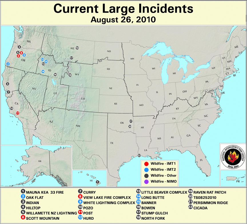
Fires currently burning (some of which are not on the map) include:
Larkins Let It Burn Complex Fires (ID); Clearwater NF; Size: 749 acres; Percent Contained: 0% [here]
Scott Mountain Let It Burn Fire (OR); Willamette NF (OR); Size: 935 acres; Percent Contained: 0% [here]
Gravel Let It Burn Fire (WY); Bridger-Teton NF; Size: 433 acres; Percent Contained: 0% [here]
Hurd Fire (ID); Boise NF; Size: 506 acres; Percent Contained: 15% [here]
Alder Creek Fire (ID); Lolo NF; Size: 425 acres; Percent Contained: 5% [here]
Fire 264 Let It Burn Complex (OR); Mt. Hood NF; Size: 500+ acres; Percent Contained: 0% [here]
Banner Let It Burn Fire (ID); Salmon-Challis NF; Size: 2,077 acres; Percent Contained: 18% [here]
White Lightning Fire (OR); Warm Springs Reservation; Size: 33,016 acres; Percent Contained: 40% [here]
Eight Mile Lake Let It Burn Fire (WA); Okanogan-Wenatchee NF; Size: 119 acres; Percent Contained: 0% [here]
Arthur 2 Let It Burn Fire (WY); Yellowstone National Park; Size: 200 acres; Percent Contained: 0% [here]
Vernon Let It Burn Fire (CA); Yosemite National Park; Size: 160 acres; Percent Contained: 0% [here]
Thunder Let It Burn Fire (WA); Okanogan-Wenatchee NF; Size: 125 acres; Percent Contained: 0% [here]
Oak Flat “Appropriate Response” Fire (OR); Rogue River-Siskiyou NF; Size: 4,760 acres; Percent Contained: 75% (allegedly) [here]
Sheep Let It Burn Fire (CA); Kings Canyon National Park; Size: 2,425 acres; Percent Contained: 0% [here]
Hopper Let It Burn Fire (WA); Olympic National Park; Size: 385 acres; Percent Contained: 15% (not by firefighters) [here]
Little Beaver Complex Let It Burn Fire (ID); Boise NF; Size: 5,350 acres; Percent Contained: 0% [here]
Bighorn Let It Burn Fire (ID); Salmon-Challis NF; Size: 1,128 acres; Percent Contained: 0% [here]
Bull Let It Burn Fire (WY); Bridger-Teton NF; Size: 3,539 acres; Percent Contained: 0% [here]
Twitchell Canyon Let It Burn Fire (UT); Fishlake NF; Size: 4,482 acres; Percent Contained: 0% [here]
This is the centennial year of the Great Fires of 1910, and much discussion has taken place about megafires and why, how, and when they arise [here].
From old SOS Forests, the archived version [here]
Palousers
July 24th, 2007
… Today the wind shifted, and a cold, dry front is blowing through right now as I type. The clouds have cleared, the sky is blue, the sun is shining, it’s 60 degrees in the shade at 10 AM, and the wind is from northwest at 15 to 20 mph. That’s what a cold front in July looks and feels like around here.
Whereas the weather here in western Oregon is balmy, across the Cascades to the east something else is happening. The same fronts are blowing across the continental plateau between the Cascades and the Rockies, but with a magnified effect. When southwesterly warm fronts swap places with northwesterly cold and dry fronts over the continent, big winds are generated.
A 15 mph wind in western Oregon can turn into a 50 mph wind on the high deserts of eastern Oregon and Washington, and then it can slam into Idaho and Montana and go sweeping down the other side of the Rockies into Wyoming and the Dakotas at gale force.
These summer westerly wind storms are known as Palousers because they seem to arise in the rolling loess hills of the Palouse.
Palousers happen every summer, in pulses, as warm and cold fronts passing over the PNW interact. Most summers they are mild to strong. Some summers Palousers arise that are near hurricane force.
The windstorm of August 20-21, 1910, blew smoldering fires in the Northern Rockies into a firestorm that incinerated 3 million acres in 48 hours, killed at least 85 people, completely destroyed five towns, and partially destroyed two others, at a time when the region was sparsely populated.
That was a Palouser.
From Pyne, Stephen J., Year of the Fires: The Story of the Great Fires of 1910. 2001 Viking Press:
The old-timer was right. The fate of the fire season resided in the swirling dice rolls of the wind. The usual pattern was for cold fronts to ripple across the region every three to five days. In advance of each front, winds would freshen from the southwest, then shift to the northwest after passage. The frontal waves became a vast, slow bellows, drawing in warm, moist air from the south before driving it out with cooler dry air from the north. …The train of fronts that rattled through the Northwest beginning in early July captured this arc of moist air, gulping it in, then exhaling it out. The rhythm of the fronts set the rhythm of the burning.
Each surge of air would stir up old flames and trigger dry lightning storms that kindled new fires. …In the Northern Rockies the approaching fronts drew the winds from the arid Columbia Plains and loess-capped Palouse–thus the Palousers of which the old-timer warned Morris. This was an ancient rhythm. But in 1910 the drought was worse, the storms held more lightning and less rain, the organization sagged from fatigue. The mid-July fire bust strained the Forest Service to its limits. Yet there was no real pause; climax followed climax; the big breakout of 23 July; the flare-ups of 1-2 August, 11-12 August, and 16-17 August; the Big Blowup of 20-21 August. Each built on the last, each fanned little fires into big ones and big ones into conflagrations, until at last a dusting of cold and wet began to dampen them out on 24 August. …
That post was sadly prophetic. The cold front of July 24, 2007, fanned a dozen Let It Burn fires in Idaho and led to the incineration of much of the Payette and Boise National Forests. Over 800,000 acres (1,250 square miles) of forested watersheds were fried [here, here].
What we wrote then still applies:
Big winds plus active fires can lead to regional firestorms. It has happened before. Conditions today are very similar to those in the Summer of 1910, except perhaps that the fuel loadings are much greater, and of course, a few million people live in Idaho and Montana now, with all their homes and stuff.
A regional firestorm today would be one of the most terrible disasters ever to strike in American history. Whatever we can do to avoid it, like putting the fires out [instead of allowing them to burn] and pre-treating the forests and ranges (too late for that this summer), we ought to do.
Federal forest policy Forestry education Saving Forests The 2010 Fire Season
by admin
11 comments
Some Let It Burn Questions Answered
Correspondent Zeke asked some pertinent questions regarding the Oak Flat Fire [here].
Dear Zeke,
Thank you for your questions. Here are the answers:
1. This fire could indeed have been contained at 800 acres. On Aug 15 the fire grew from 600 to 800 acres. On that date there were already nearly 500 firefighting personnel on the scene, 8 helicopters, and air tankers standing by in Medford.
The area is not “wilderness” or roadless. It is well-roaded throughout. No additional dozer work was necessary to contain the fire. There have been no strong winds so far, thank goodness, or the fire would have swept into Grants Pass within hours. Allowing the fire to grow and grow for weeks on end runs the risk that winds will arise and the fire will become a major disaster, burning farms, homes, towns, and cities. The USFS has chosen to endanger tens of thousands of residents, none of whom had any say so in the matter. That increased risk is manifest right now and will be for weeks to come.
2. It was and is possible to SAFELY put this fire out by ‘going direct’ on it. Indirect attack is LESS SAFE. Right now the “plan” is to put 1,000 firefighters a day for weeks on this fire. That is 10 to 20 times the man-hours necessary to contain it. By expanding the man-hours enormously, the risk of accidents increases.
Most firefighting injuries and fatalities are not due to burning up. They are due to machine accidents and fireline accidents, such as helicopter crashes and falling trees. The chance that those kind of accidents will occur is INCREASED by extending the fire for weeks and by extending the fire perimeter 10-fold.
3. There are no “benefits” to resources from wildfire. The USFS does not claim such. The use of the term “wildland fire used for resource benefit” is kaput. You can read the memo [here].
It is important to note that the deliberate use of fire produces significant impacts to the environment. We have laws regarding federal agencies impacting the environment, such as NEPA. If you read that law, you will note that “benefit” or “detriment” do not matter. What matters is whether the impacts are “significant”. No one argues that fire effects are insignificant.
Yet the USFS did not follow the legally mandated NEPA process before deciding to expand this fire ten-fold. They broke the law. That makes them criminals. Nobody wants federal agencies to break the law. I don’t at any rate. Do you?
For more discussion on this aspect, see [here, here, here, here].
4. Instead of looking at Google Earth, you may wish to examine the forest road map. That will show you the existing road density of the area. The road network is extensive. No new roads are needed, or new dozer lines, to contain this fire.
5. 6. 7. So you think that they could have held it to this footprint? Have you ever fought fire in that country? Are you an expert on wildfire tactics? Yes, Yes, Yes.
8. Is anything about that ground worth killing a single firefighter? Hold on there, Zeke. I am not for killing anybody. As I discussed above, extending the fire in time and space INCREASES the risks to firefighters.
In 2008 over 650,000 acres were incinerated in Northern California on the Shasta-Trinity, Six Rivers, and Klamath National Forests. The fires were allowed to burn vast tracts in accord with a revised fire policy the USFS called “Appropriate Management Response” (since then the USFS has dropped that lingo term, too). Building firelines miles away from the fires and backburning hundreds of thousands of acres of private and public land alike were deemed “appropriate.” Despite the remote firefighting techniques, ostensibly intended to save money and protect firefighters, over $400 million was spent on suppression and 12 firefighters were killed.
In 2009 direct attack was used on a fire in the same area. The Backbone Fire [here] was 6,100 acres in steep un-roaded country when the decision was made to use direct attack. The fire was 100% contained within a week at 6,324 acres, with no accidents and no fatalities.
So you see, Zeke, extending this fire is far more likely to result in death to firefighters than direct attack would have. Perhaps you should aim your “killing firefighters” question at the USFS instead of at me.
9. What do you hope to accomplish with your rant? My purpose, indeed the purpose of W.I.S.E., is to educate. The “rant” characterization is impolite on your part, but whatever the literary quality, my post caught your attention. And now I am educating you further. Please read (study) the links provided. You have much to learn, and we are here to aid you in that.
Thank you again for your questions. Please feel free to ask us such good questions anytime.
Sincerely,
Mike Dubrasich, Exec Dir W.I.S.E.
Federal forest policy Monkeywrenching forests The 2010 Fire Season
by admin
11 comments
Criminal Incineration of the Rogue River-Siskiyou NF
The Oak Flat Fire [here] was reported this morning to be 1,706 acres. The plan, however, is to allow the fire to grow to 12,000 acres, either through inaction or deliberate backfiring.
The Oak Flat Fire was ignited by unknown causes in the Briggs Creek area of Rogue River-Siskiyou NF, about 10 miles west of habitations in the Rogue River Valley and 8 miles northwest of the community of Selma in the Illinois River Valley.
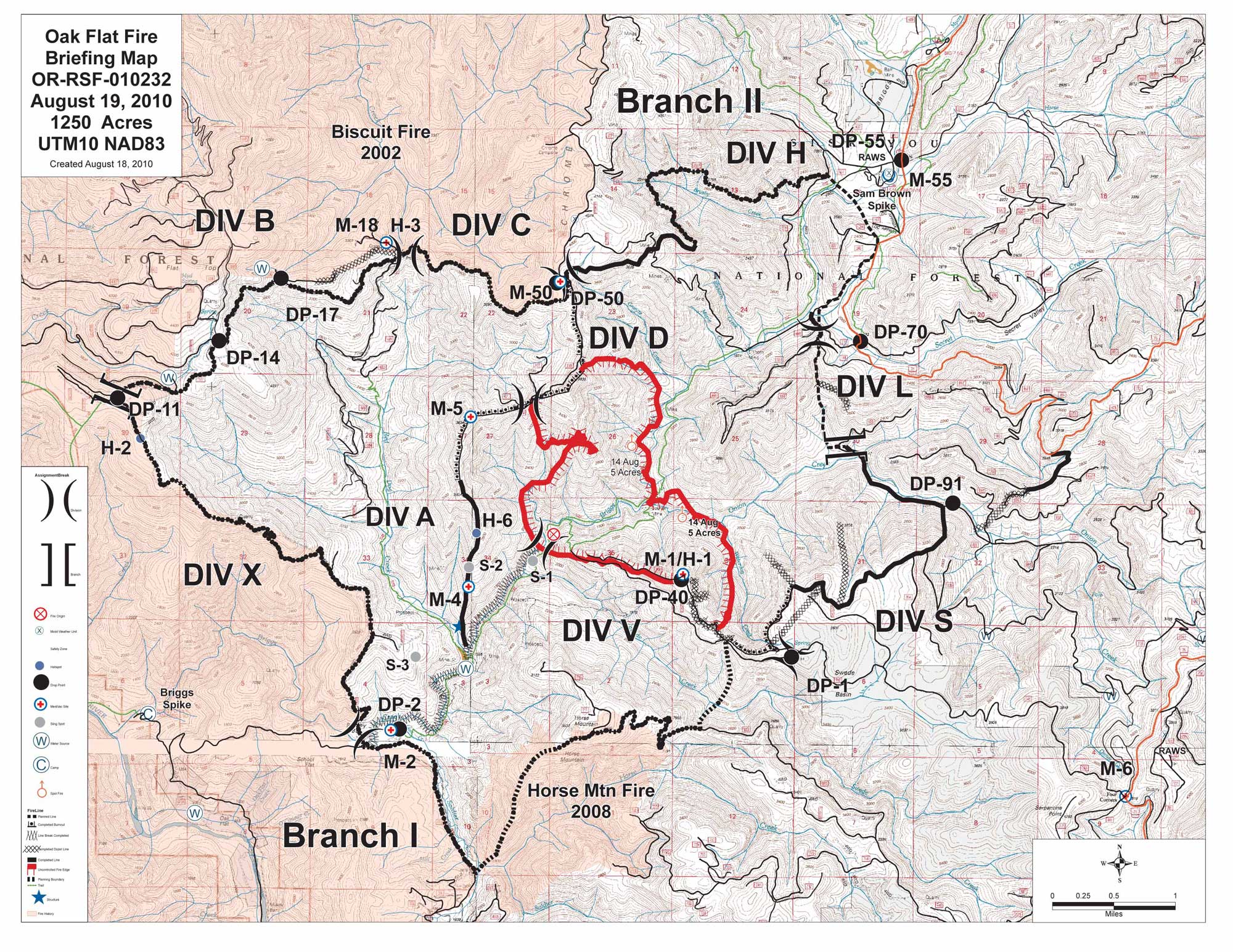
Oak Flat Fire Briefing Map, August 19, 2010. From InciWeb [here]. Click for larger image.
The red outlined area is the current fire perimeter. The black lines indicate the positions of the “indirect” fire lines planned by the Southern Oregon/Northern California Type II Interagency IMT Incident Commander Brett Fillis [here] in collaboration with the Rogue River-Siskiyou NF Forest Supervisor Scott Conroy, and with the approval of Region 6 Regional Forester Mary Wagner.
The black lines encompass approximately 12,000 acres. The area to be burned includes portions of the Illinois Valley Wild and Scenic River corridor. It also includes known nesting sites of the Northern Spotted Owl, a species on the Threatened and Endangered Species list.
InciWeb reported:
…[F]ire managers are planning to conduct burnout operations aimed at efficiently connecting the fire into the containment lines within the few days. Both ground and aerial ignition methods will be used, with particular attention paid to minimizing tree mortality and preserving spotted owl habitat. …
The Regional Forester reviewed the fire management plan, activities and organization on Thursday, 8/19/10.
That language implies that deliberate ignition of spotted owls stands will be occurring as the fire managers expand the footprint of the fire 10-fold. Further, those operations have been approved by Regional Forester Mary Wagner.
Deliberate incineration of endangered species habitat is a violation of the Endangered Species Act. The USFS has not conducted any NEPA analysis, such as an Environmental Impact Statement. Nor have they conducted any Section 7 (of the ESA) consultation with the US Fish and Wildlife Service.
The entire area is an ancient cultural landscape, as indicated by place names such as Oak Flat and Onion Mountain. Soldier Creek was named during the Rogue River Indian Wars [here] of the 1850’s. As such the area has significant archaelogical and heritage sites. No Section 106 review (of the National Historical Preservation Act [here]) has been conducted.
The USFS is well-aware that deliberately expanding a wildfire by backburning thousands of acres of legally protected landscapes is illegal.
In March of 2008, the Rogue River-Siskiyou National Forest issued a notice of intent to produce a Fire Use Amendment Environmental Assessment [here] that would change the language in their Land and Resource Management Plan and Fire Management Plan to include “allowing” wildfires to burn across vast acreages.
That plan amendment has NOT been adopted. Serious objections have been raised and appeals filed. What the final outcome will be is unknown, but the Fire Use Amendment has NOT been adopted as yet.
Regardless, USFS officials are proceeding as if the laws do not apply to them.
This is not the first time the Rogue River-Siskiyou NF has ignored the law. Adjacent to the planned fire perimeter of the Oak Flat Fire is the Biscuit Burn, a 500,000 acre scar that resulted from a Let It Burn fire of 2002. The Biscuit Fire was the largest fire in Oregon state history and eventually cost over $150 million to suppress when it blew up into a 12-mile-long fire front and threatened the communities of Selma and Grants Pass (the same communities now threatened by the Oak Flat Fire).
Over 75 Northern Spotted Owl nesting sites were destroyed by the Biscuit Fire.
In 2008 the Rogue River-Siskiyou NF perpetrated another illegal Let It Burn fire, the Lonesome Complex/Middlefork Fire [here], which was allowed to grow from 500 acres to 21,000 acres, incinerating numerous old-growth and Northern Spotted Owl nesting stands.
The criminal activities by Federal government functionaries on the Oak Flat Fire will have devastating impacts to wildlife, wildlife habitat, heritage, scenery, recreation, and other natural resources. Those impacts will be long-lasting. Furthermore, allowing the fire to burn for weeks on end will pour smoke into communities and cause severe public health problems. Expanding the planned fire perimeter and backfiring thousands of acres will exacerbate those damages.
Allowing the fire to burn for weeks on end also runs the risk that a wind event could cause a fire blow-up and carry the fire to private lands and communities.
None of those communities, or their elected officials or representatives, have any influence over the USFS fire decisions. The USFS acts like an occupying army with no regard for the local residents or the law, and with the malicious intent to devastate and destroy watersheds and landscapes no matter what the impact may be resources or to the local communities.
The Oak Flat Fire is growing and will continue to grow, due to deliberate actions of the USFS, because the criminals in charge feel that they are impervious to legalities and public opinion. But there will be a denouement after this fire. Their crimes will not be swept under the rug this time.
Ninth Court Upholds Restoration in Spotted Owl Forest
In a stunning and precedent-setting decision yesterday, the Ninth Circuit Court of Appeals reversed a lower court and upheld the Five Buttes Project on the Deschutes National Forest.
The Project [here, here] is planned for the Five Buttes area (near Odell and Davis Lakes) in the Crescent Ranger District approximately 50 miles south of Bend, Oregon. It includes 4,235 acres of commercial thinning, with an estimated volume of 14.4 million board feet; 4,235 acres of fuels treatments associated with commercial harvest units; 3,931 acres of fuels treatments in units (including 368 acres in Unit 435) that will not have commercial harvest at this time; and 5.9 miles of temporary road construction and rehabilitation of temporary roads when they no longer are needed.
The Five Lakes Project has been in the planning process since 2004, in part in response to the 2003 Davis Fire (21,000 acres). The League of Wilderness Defenders, Blue Mountains Biodiversity Project, Cascadia Wildlands Project, and the Sierra Club sued to halt the Five Lakes Project, winning an injunction [here] from Michael R. Hogan, U.S. District Court for the District of Oregon in 2008. The US Forest Service appealed, and Hogan’s decision was reversed [here] yesterday by Richard A. Paez, Richard C. Tallman, and Milan D. Smith, Jr. of the Ninth Circuit Court. Smith wrote the majority opinion, and Paez wrote a dissent.
Attorneys for Daniel Kruse, Cascadia Wildlands Project [here] and Christopher Winter and Ralph Bloemers, Crag Law Center [here] argued that another large fire in the Five Buttes Project area was highly unlikely. Interestingly, less than a week after the Hogan decision in 2008, the Royce Butte Fire [here] erupted in the Five Lakes Area, forcing evacuations of Crescent Junction.
While Judge Paez, in his dissent, argued that the risk of catastrophic fire in the Project area was “inconsistent,” the majority disagreed. Judge Paez cited John Muir, God, and Uncle Sam in his dissent:
Old-growth forest is the end result of an ancient and intricate process. Its ecosystem is rich and complex, and because we do not fully understand the inner workings of the relationships between the plants and species that inhabit them, human harm to old-growth forests remains irreversible. In the words of John Muir, a preservationist and the man largely credited for the creation of Yosemite National Park:
“It took more than three thousand years to make some of the trees in these Western woods,—trees that are still standing in perfect strength and beauty. … God has cared for these trees, saved them from drought, disease, avalanches, and a thousand straining, leveling tempests and floods, but he cannot save them from fools,—only Uncle Sam can do that.” John Muir, American Forests, Atlantic Monthly, Aug. 1897, at 145, 157.
But fortunately the other judges were not so full of it. Everything Paez (and Muir) states above is false. The interjection of religious myth into judicial decisions is a clear violation of the separation of Church and State as established in the U.S. Constitution. It is kind of amazing that Federal Judge, especially a Ninth Circuit liberal judge like Paez, would base his judgment on (clearly racist) religious claptrap nonsense. But it doesn’t matter. Paez was out-voted by the rest of the judicial panel.
The Pantiffs argued that “commercial” harvest for “profit” is a terrible thing and should never be allowed. While not saying so expressly, the goal of shutting down the economy by eliminating “profit” is part of Marxist doctrine. It is remarkable how many people bad mouth “profit” these days. They prefer losses, evidently, except in their own personal finances. But that is neither here nor there.
The fanciful idea that spotted owls cannot abide thinning is debunked by numerous situations where owls have thrived in thinned forests. It is good to see that myth dashed on the rocks of reality.
The idea that removing fuels has no effect on fire risk was also debunked in this ruling. Obviously it does.
The pro-holocaust, anti-forest, super-litigious “enviros” were thumped by this precedent-setting ruling. It’s nice to see the bad guys lose once in awhile.
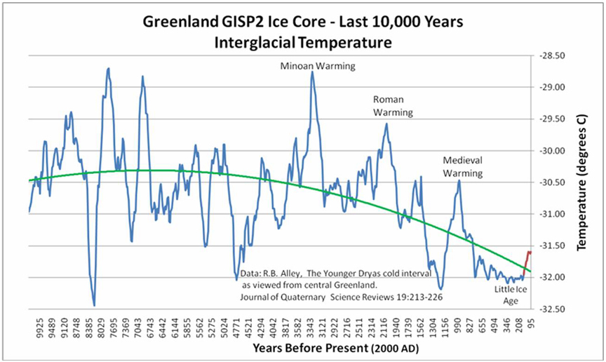
Greenland Glacial Calving and Sea Level
SOSF Note: Special thanks to Joe D’Aleo of ICECAP [here] for his stalwart efforts to debunk global warming hysteria.
by Nils-Axel Mörner, ICECAP, Aug 13, 2010 [here]
ICECAP Note:
Last week another alarmist story appeared in the [UK] Guardian quoting Richard Alley, professor at the once great Penn State University in which it reported on the natural calving of a large chink of the Petermann glacier in Greenland. They noted “Greenland shed its largest chunk of ice in nearly half a century last week, and faces an even grimmer future, according to Richard Alley, a geosciences professor at Pennsylvania State University.
“Sometime in the next decade we may pass that tipping point which would put us warmer than temperatures that Greenland can survive,” Alley told a briefing in Congress, adding that a rise in the range of 2-7 C would mean the obliteration of Greenland’s ice sheet.”
We asked a real expert on sea level, Nils-Axel Morner to comment. Here is what he had to say:
No ”huge rise in sea level” to foresee: Observation rules out modeling
Recently, “a panel of leading geoscientists told the US Congress” that sea level is likely to rise by 7 metres within this century. What nonsense, we must say. Not only, is this against observational facts, it is also against physics.
At the Last Ice, the huge ice caps over Europe and North America had their southern margins way down at mid latitudes (at Hamburg in Europe and at New York in North America). When climate changed, the ice melted at a very rapid rate. At Stockholm, for example, the ice margin was displaced northwards at a rate of about 300 m per year. Indeed, an enormous speed. Still, global sea level did not rise more than about 10 mm per year or 1 metre in a century. This rate sets the absolutely ultimate physically frame of any possible sea level rise today. Any claim exceeding this value must be classified as shear nonsense. It is as simple as that.
The Greenland Ice Cap did not melt during the postglacial hypsithermal (some 5000 to 8000 years ago), when temperature was about 2.5 degC higher than today. Nor did it melt during the Last Interglacial when temperature was about 4 degC higher than today. As to time, it would take more than a millennium (with full thermal forcing) to melt the ice masses stored there.
The panel also talk about a possible “tipping point”. Well, the only event of that type we can be fairly sure about, seems to be the approaching turn from a Solar Maximum (just passed) to a Solar Minimum (calculated at around 2040).
The view presented by the panel is another sad expression of IPCC propaganda. What they say is not founded in geoscientific knowledge and physical laws. The World is far too full of real problems that call for immediate consideration to waste time on wild exaggerations.
Nils-Axel Mörner, (Sea level specialist from Sweden)
Paleogeophysics and Geodynamics
ICECAP Note: In actual fact, Alley’s own chart should tell you we do not have a problem in Greenland. In fact, if anything, the data may be suggesting a movement towards a new ice age.
Ten Forest Restoration Projects Selected by USFS
The US Forest Service has selected ten landscape-scale forest restoration proposals nationally to begin implementation of Title IV - Forest Landscape Restoration of the Omnibus Public Land Management Act of 2009 [here, here, here, here] (among many other posts - for the full panoply see here).
Out of the 150 national forests in the system, 31 submitted CFLRP project proposals [here]. Regional Foresters screened proposals first, so the 31 possibly represent a reduced subset of the total number proposed at the forest level.
The ten projects selected are:
* Southwestern Crown of the Continent, MT
* Uncompahgre Plateau, CO
* Colorado Front Range, CO
* 4 Forest Restoration, AZ
* Southwest Jemez Mountains, NM
* Dinkey Landscape, CA
* Tapash, WA
* Deschutes Skyline, OR
* Northeastern Florida, FL
If Congress continues to fund the CFLRP, ten more landscape-scale forest restoration proposals will be selected next year and in future years.
These first proposals are of varying quality; it is possible that future projects (and proposals) will be better, having been informed by this first go-around.
On the other hand, the language in some of the proposals is completely obnoxious. Why our government has to talk in Stalinese is beyond me. The uber Potemkin Village rhetoric is depressing.
Also, there is no discussion in any of the proposals regarding landscape history, particularly cultural landscape aspects. Even the Yakama Nation is apparently unaware that they have a heritage on the land — they certainly don’t discuss that aspect in their proposal. It is not clear what the USFS thinks it is that is to be restored.
Also, there is no discussion of the overall USFS mission and how the proposals might or might not dovetail with that.
These are fumbling, stumbling first steps. I suppose it is the best that can be expected from the competency-challenged folks we have hired.
As usual we welcome your comments. You may wish to inspect the proposals first.
Federal forest policy Private land policies Useless and Stupid
by admin
4 comments
All Lands Management, Government-Style
Once again the US Forest Service is blaming everybody but themselves for catastrophic megafires that arise on unkempt, fuel-laden Federal lands and are exacerbated by the USFS’ own Let It Burn policies.
Agriculture Secretary Tom Vilsack blames all those private homes, including those that haven’t been built yet, within 30 miles of the unmitigated hazards the USFS has created.
The solution: eliminate all homes with 30 miles of Federal lands. In other words, strip the Western U.S. of all residents. Heck, strip the eastern half, too.
The Federal Government can’t prevent illegal immigrants from pouring over the border, but they are all hot to get the bayonets and cattle cars out to drive legal resident humanity off the continent.
When the Station Fire burned down 89 residences, when the Angora Fire burned down 254, when the Cedar Fire burned 3,241 homes and killed 16 people, whose fault was that? Not the folks who mismanage and unmanage the Federal Estate. Nope, it was the victims who were so self-interested and disregarding of the commonweal as to build a home within 30 miles of Federal land.
Vilsack Highlights Report Showing Threats to Private Forested Lands
Forest Service study supports “All Lands” approach outlined by Vilsack last year
USDA Press Release No. 0401.10, August 11, 2010 [here]
Washington, D.C. - Agriculture Secretary Tom Vilsack today held a national conference call to highlight a USDA Forest Service report entitled Private Forests, Public Benefits [here], showing that privately held forests in the U.S. are under substantial stress from development and fragmentation, and that increased housing density in forests will exacerbate other threats to forests from wildfire, insects, pathogens and pollution. These threats to the important goods and services provided by privately owned forests — which make up 56 percent of all forested lands — emphasize the importance of the collaborative, cross-boundary approach to conserving and restoring our forests as laid out by Secretary Vilsack in a major address last year.
“Americans rely on their forests for a wide range of social, environmental and economic benefits, including clean water, wood products, habitat for wildlife, and outdoor recreation,” said Vilsack. “The Private Forests, Public Benefits report shows that now, more than ever, we need to take an ‘all lands’ approach to managing our nation’s forests, whether they are national forests or under the stewardship of state or private entities.” …
The study touted above is a product of the USFS Open Space Conservation Strategy [here], the brainchild of former USFS Chief Gail Kimbell.
There is no (none, zero, nada) stautory directive from Congress to engage in the Open Space Conservation Stategy. The civil servants thunked it up all by their lonesomes.
Congress did not order it, the Pipple did not order it, it has never been through any democratic process. It’s just another wild and crazy scheme drawn up by overpaid, underworked, government functionaries with too much power and too much time on their hands. With your money.
Illegal USFS ESA Snap Decisions for Wildfire “Use”
The time between the discovery of a wildfire and the decision to Let It Burn is no more than 24 hours. Once the decision is made to withhold initial attack and “use” the wildfire for “resource benefit,” there is no turning back — the wildfire usually will have grown too big to contain within a small area.
How long does it take to do a fast-tracked, emergency analysis for endangered species? The USFS says two months minimum:
USFS Delays Timber Harvest After Owls Spotted In Area
by Amelia Templeton, Oregon Public Broadcasting, July 30, 2010 [here]
The Forest Service is delaying a timber harvest in the Willamette National Forest. A pair of threatened spotted owls has moved closer to the area slated for logging.
The Seneca Sawmill agreed to pay about a half million dollars to log 150 acres of National Forest land. The harvest was supposed to begin on Monday.
But last week researchers learned that a pair of spotted owls has moved closer to the site.
Forest Service spokeswoman Judy McHugh says the logging contract has been suspended for two months to allow for a study.
Judy McHugh: “U.S. Fish and Wildlife has to do their analysis and their conclusion about what activity in the area does to individual owls and the owl population as a whole.”
Think about it. The USFS has to get permission to log from the USFWS if endangered species might be impacted. That permission comes (or possibly doesn’t) via what is called a “Section 7 consultation,” which refers to Section 7 of the Endangered Species Act (ESA).
Normally the USFS will engage in a planning process (required by NEPA, the National Environmental Policy Act) before a timber sale. The NEPA process includes Section 7 consultations with the USFWS, as well as public comment and appeal periods. The NEPA process typically takes years (plural) for each project.
However, in the case of the timber sale mentioned above, the situation changed after a pair of spotted owls allegedly “moved closer” to the project area.
By the way, the timber sale in question is the Trapper Project, a 155 acre harvest initially proposed in 1998 [here]! The Environmental Assessment was written in 2003. So the project has been in the planning and evaluation process for 12 years!
How fast can the USFWS turn around an emergency Section 7 consultation on a 155 acre area that has already been studied to death for 12 years?
Two months.
How much time is available to do a Section 7 consultation on a wildfire proposed for “fire use” that has not been studied, for which no spotted owl (or other T&E species) investigations have been made, for which the area to be burned is unknown but typically involves many thousands of acres?
Less than 24 hours.
The USFS is desperate to avoid doing any NEPA analysis on Let It Burn fires. They know that if they were required to obey the law and do a NEPA analysis on a lightning ignition, there is no way the NEPA process could be completed in the narrow time window between ignition and the decision to Let It Burn.
That’s why NEPA analyses, including Section 7 consultations, are never done for Let It Burn (or “allow to burn” or “fire use” or whoofoos or whatever unplanned, unfought conflagrations are called these days).
Criminal behavior on the part of the USFS?
What else would you call it?
Politics and politicians Restoring cultural landscapes Saving Forests The 2010 Fire Season
by admin
1 comment
Another Forest Tragedy
The Rooster Rock Fire [here] near Sisters, Oregon is now 6,124 acres and 65% contained. It is unlikely to grow any larger because winds have died down and the CO2’s (Central Oregon Type 2 Incident Management Team, Mark Rapp I.C.) in cooperation with the Oregon Dept. of Forestry have done their usual excellent job of controlling the fire.
The fire began from unknown causes on US Forest Service (Deschutes NF) land on August 2nd. It quickly spread east and south to private lands. Approximately three-quarters of the area burned by the Rooster Rock Fire is private land.
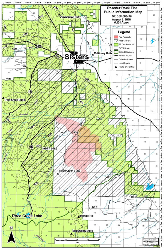
Rooster Rock Fire Map, 08/06/2010, courtesy Central Oregon IMT. Click for larger image.
The fire was about 5 miles south of Sisters. A few homes were evacuated, but the evacuations have now been lifted. An estimated 50 homes were threatened, but no homes burned.
The Rooster Rock Fire was the 13th large fire in the northern Deschutes NF in the last 8 years. Over 160,000 acres, primarily in the the Metolius River watershed, have been incinerated. The scar of burned old-growth now extends from Warm Springs to the north to the Three Sisters Wilderness to the south, from the Cascade Crest to private lands to the east. The following Burns make up this destroyed forest landscape (this list is missing a few smaller ones):
Cache Mountain Fire (2002) - 3,894 acs
Eyerly Complex Fires (2002) - 23,573 acs
B&B Complex Fires (2003) - 90,769 acs
Link Fire (2003) - 3,574 acs
Black Crater Fire (2006) - 9,400 acs
Puzzle Fire (2006) - 6,150 acs
Lake George Fire (2006) - 5,740 acs
GW Fire (2007) - 7,500 acs
Dry Creek Fire (2008) - 110 acs
Summit Springs Complex Fires (2008) - 1,973 acs
Wizard Fire (2008) - 1,840 acs
Black Butte II Fire (2009) - 578 acs
Rooster Rock Fire (2010) - 6,124 acs
Total - 161,225 acres in eight fire seasons