Ancient Human Environmental Influences In Yellowstone
It turns out that Yellowstone is not a pristine, untrammeled wilderness after all.
Science Daily reported today that a 10,000-year-old hunting shaft (atlatl dart) has been discovered in the Rockies near Yellowstone.
Hunting Weapon 10,000 Years Old Found in Melting Ice Patch
ScienceDaily, June 29, 2010, [here]
To the untrained eye, University of Colorado at Boulder Research Associate Craig Lee’s recent discovery of a 10,000-year-old wooden hunting weapon might look like a small branch that blew off a tree in a windstorm.
Nothing could be further from the truth, according to Lee, a research associate with CU-Boulder’s Institute of Arctic and Alpine Research who found the atlatl dart, a spear-like hunting weapon, melting out of an ice patch high in the Rocky Mountains close to Yellowstone National Park.
The US Forest Service didn’t invent Let It Burn, the National Park Service (NPS) did.
The most infamous Let It Burn fires in our National Parks were the Yellowstone Fires of 1988 when 1.2 million acres (1,875 square miles) of Greater Yellowstone were proudly incinerated by the NPS.
It is not a stretch to say “proudly” because the NPS gushes all over itself for the Yellowstone Fires [here].
Among the justifications presented by the NPS for the Yellowstone Fires was that the fires were “natural”, as if “natural” made any difference.
The natural history of fire in the park includes large-scale conflagrations sweeping across the park’s vast volcanic plateaus, hot, wind-driven fires torching up the trunks to the crowns of the pine and fir trees at several hundred-year intervals.
Such wildfires occurred across much of the ecosystem in the 1700s. But that, of course, was prior to the arrival of European explorers, to the designation of the park, and the pattern established by its early caretakers to battle all blazes in the belief that fire suppression was good stewardship.
That bit of racist nonsense fails to mention that Native Americans had been residing in and visiting the Yellowstone region for at least 11,900 years. The “early caretakers” were not the NPS!!! The actual early acretakers set frequent, seasonal, non-catastrophic fires that precluded holocausts like 1988.
The ignorant racism was readily adopted by NPS “scientists” too:
…[B]y the 1970s Yellowstone and other parks had instituted a natural fire management plan to allow the process of lightning-caused fire to continue influencing wildland succession. …
Only a miniscule portion of once vast wilderness landscapes has been preserved, and the boundaries and spatial extent of these preserved bear little relationship to the natural processes necessary for their preservation. The 1988 fires have laid bare the broad extent of our ignorance of those natural processes. — N. A. Christensen, et al.
The NPS is profoundly ignorant of the historical human influences on ecosystem development in all of our national parks. They have blinders on in that regard. NPS fires wipe out any trace of the real natural history on those landscapes. It’s more than ignorance — it’s their deliberate policy to do so. That is because the foundational conceit of the NPS is the American Creation Myth: God made the Wilderness for the Salvation of Humanity, specifically Euro immigrants as paternally cared for by NPS neo-Victorian elitists.
But Yellowstone is not wilderness. Modern (non-NPS) scientists are well-aware of the historical human environmental influences in the Yellowstone and the non-wilderness (homelands) quality of that cultural landscape.
The newly discovered atlatl dart is proof that human beings have been living in the Yellowstone area for (at least) 10,000 years. It is proof that for millennia human beings have been the key predators, the most effective and deadly hunters, armed with advanced technology capable of killing any other animal.
The dart is circumstantial evidence that human beings have controlled animal populations in the Yellowstone area for 10,000 years.
Because human beings everywhere, for our entire existence as a species, also employed landscape anthropogenic fire, the atlatl dart is circumstantial evidence that human beings have been burning Yellowstone deliberately, frequently, for survival purposes, for 10,000 years.
The Science Daily article continues:
Later this summer Lee and CU-Boulder student researchers will travel to Glacier National Park to work with the Salish, Kootenai and Blackfeet tribes and researchers from the University of Wyoming to recover and protect artifacts that may have recently melted out of similar locations.
“We will be conducting an unprecedented collaboration with our Native American partners to develop and implement protocols for culturally appropriate scientific methods to recover and protect artifacts we may discover,” he said.
Modern Native Americans, archaeologists, historians, and cultural experts recognize the continuity of human occupation of the landscape for many hundreds of generations. It wasn’t until the Euro-Victorians came along that humanity was driven off the land.
An important component of restoration is the reintroduction of humanity into the landscape, including the restoration of human-nature connections and traditional practices. Thus restoration is at odds with the American Creation Myth and with the NPS policy of denying human heritage and historical human influences on the environment.
Restoration seeks to restore the anthropogenic fire and anthropogenic wildlife management extant for the entire Holocene, save the last 150 years or so. That is why the current NPS policy of banning hunting and allowing catastrophic lightning fires to incinerate watersheds during the peak summer months is anathema to restorationists.
We look at the myth-bound, arguably racist, definitely destructive policies of the NPS and wonder how such horrific policies ever became ingrained, and how we might shake the NPS out of it’s ignorance and destructiveness.
Sabotaging Flagstaff’s Forests
The Schultz Fire [here] is winding down. Today the Southwest Type 1 Incident Management Team will be transferring fire management to the Coconino National Forest. To date 15,075 acres have burned north of Flagstaff, AZ. No homes were destroyed. The fire is trailed on 65 percent of the perimeter and is no longer growing. To date $7 million has been spent on fire suppression.
We have discussed the Schultz Fire previously [here, here]. We noted:
The Schultz Fire outside of Flagstaff has been predicted for 30 years. Dr. Wally Covington, his Ecological Restoration Institute at NAU, the City of Flagstaff, and community groups like the Greater Flagstaff Forest Partnership have all pushed and pushed for fuel treatments and restoration. Everyone with half a brain recognized that a-historical fuel loadings have accumulated in a wind tunnel/venturi between the mountain peaks, and the accelerated winds are aimed directly at Flagstaff. The ongoing efforts and pleadings by ERI, GFFP, foresters and others to reduce the hazards through restoration have been thwarted again and again by radical anti-stewardship groups…
The Flagstaff paper, the Arizona Daily Sun, published an interesting article yesterday that lays the blame at the feet of the Center for Biological Diversity [here], the multi-million dollar, super-litigious, anti-forest, pro-holocaust “activist” group headquartered in Tucson.
Why wasn’t Schultz Pass thinned?
by CYNDY COLE, AZ Daily Sun, June 27, 2010 [here]
… The same area where the Schultz fire ignited and began burning heavily was due to be thinned three years ago, from Schultz Pass to the forest west of Timberline.
But after an appeal from an environmental group delayed the project, the economy went into a tailspin, closing the window on starting the project.
A similar project on the west side of the Peaks on Hart Prairie also has been appealed and will be delayed.
The idea at Schultz Pass was to protect residents living near the Coconino National Forest from wildfires by thinning and starting low-intensity prescribed burns across a total of 9,660 acres.
The Center for Biological Diversity appealed the project planned for Schultz Pass in 2007.
“It would have left fewer large trees and less canopy for wildlife than is called for in the forest plan,” wrote Taylor McKinnon, who works on public lands for the Center for Biological Diversity. …
This past week, the Coconino National Forest proposed another thinning and logging project on 9,800 acres of Hart Prairie to reduce fire danger, among a couple others to come.
More complex than any other project on the forest so far, the Hart Prairie project is also aimed at keeping dying aspen alive by a variety of sometimes experimental activities, including falling logs crosswise, fencing off ponds that elk drink from, and reducing the number of aspen-munching elk by asking Game and Fish to allow more hunting.
The Center for Biological Diversity appealed the project…
Anthropogenic Fire in Tasmania
At what is seemingly the end of the world sits the island of Tasmania. It is 150 miles south of Australia, separated by the Bass Strait, and thought by some to be the epitome of pristine, untouched nature. Not counting the modern cities, towns, farms, etc., of course.
As remote as it is, however, Tasmania has been home to humanity for at least 35,000 years. In fact, until the world’s ocean rose after the Wisconsin Glaciation some 10,000 years ago, Tasmania was a peninsula connected to mainland Australia.
The Palawa people (Tasmania aborigines, [here]) were first decimated by old-world diseases and then rounded up and exiled to Flinders Island in the 1830’s. But before those unfortunate events, they managed to survive in isolation for millennia with stone age tools.
And as SOSF readers know, the principal stone age survival tool, going back into hoary antiquity to our proto-human ancestors a million years or more removed, has been fire.
Every culture on Earth has used fire to alter their environments for various survival-enhancement purposes, and the Palawa were no different. A wonderful essay about pre-Contact anthropogenic fire in Tasmania is:
Gammage, Bill. 2008. Plain Facts: Tasmania under Aboriginal Management. Landscape Research, Vol. 33, No. 2, 241 – 254, April 2008.
now posted in the W.I.S.E. Colloquium: History of Western Landscapes [here].
Yes, I know, Tasmania is hardly “western”. But the history is similar and instructive.
Professor Bill (William Leonard) Gammage is a visiting fellow in the Humanities Research Centre, Australian National University, studying Aboriginal attitudes to land and land management from a historical perspective. His books include ‘The Broken Years: Australian Soldiers in the Great War’ (1974), ‘The Sky Travellers. Journeys in New Guinea 1938-39′ (1998), and ‘Narrandera Shire’ (1986) [here].
So he knows how to write, and what’s more, his essay has great pictures, too! The Abstract:
Almost all researchers now accept that Australia’s Aborigines were managing their country with the broad-scale use of fire when Europeans arrived. In respect to Tasmania, this article goes further, arguing that fire was not merely broad-scale, but applied variably and precisely, to make, then connect, a complex range of useful ecosystems. The article also argues that Aboriginal land management must be seen in cultural as well as ecological terms.
In SOSF lingo, that means Tasmania was a vintage cultural landscape intentionally modified into an anthropogenic mosaic by intelligent torch bearing humans.
More Geoglifo Photos
Geoglifos are ancient geometric earthen structures in Amazonia, built by civilizations that thrived hundreds and even thousands of years ago in what today is widely but incorrectly thought of as “wilderness”.
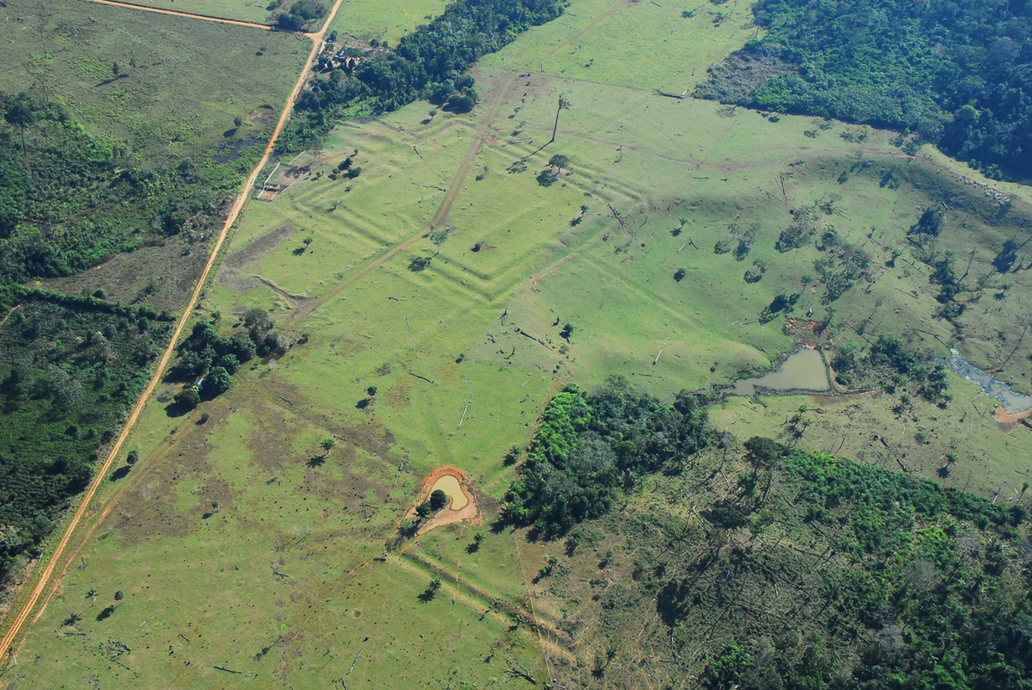
An example of geoglifos found in Acre, Amazonas, and Rondonia states. Photo courtesy Dr. William Woods. Click for larger image.
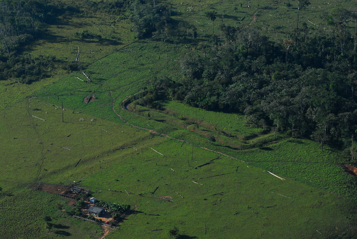
The clear implication is that the forest wasn’t there 500 years ago, but lots of people were! Many of the geoglifos are connected by kilometers of causeways or moat-like features. Photo courtesy Dr. William Woods. Click for larger image.
For additional photos, discussion, reports, and book reviews on pre-Columbian geometric earthworks in Amazonia see [here, here, here, here, here, here, here, here, here].
Federal forest policy Politics and politicians The 2010 Fire Season
by admin
17 comments
An Open Letter to Senator Mark Udall
Dear Senator Udall,
I read with interest your Newsletter Update: Fire Season in the Rockies [here] today. You note:
Fire season has officially begun in Colorado. Already we have three active forest fires across the state. The fire in the Great Sand Dunes National Park has burned nearly 5,000 acres, and on Monday, another fire near Cañon City destroyed several buildings, including at least one home. As U.S. Senator, I’m doing everything I can to ensure the Forest Service and the state have the resources they need to keep Coloradans and their property safe during fire season.
In Colorado, one of the biggest threats is bark-beetle-damaged trees. The bark-beetle epidemic, which has devastated large swaths of forest in Colorado and across the Mountain West, has created what is essentially a 3.6 million-acre tinderbox. We now have millions of acres of dead and dying trees that threaten public safety, add fuel to wildfires, endanger water supplies, and put mountain economies at risk.
Ever since I was first elected to Congress in 1998, I have been focused on maintaining the health and safety of our forests, and as your U.S. Senator, I have doubled my efforts to reduce the risks of another event like the Hayman Fire of 2002.
Thank you very much for your rational and reasonable concerns regarding fire risks to Coloradans and to the resources of the great state of Colorado. However, there may be a few items that you may be unaware of:
1. Two of the three active wildfires in Colorado today are Let It Burn fires: the Medano Fire [here] at the Great Sand Dunes NP and Pike and San Isabel NF in Saguache Co.; and the Water Creek Fire [here] on the Roan Plateau northwest of Rifle in Garfield Co.
2. By “Let It Burn” I mean the fire management strategy is not contain-control-extinguish but rather to “monitor” the fires while they burn unchecked.
3. In the case of the Water Creek Fire, the fire reports are sparse and inaccurate but some facts are evident. Wildland fire use (whoofoo) teams (modules) have assumed management of the fire. Although their job (ostensibly) is to monitor, not fight the fire, they do not file monitoring reports, ironically. The BLM, Colorado River Valley Field Office (formerly Glenwood Springs — site of Storm King Mountain Monument) is the responsible agency. Downwind of the fire are the communities of Rifle, Silt, New Castle, and Glenwood Springs. The Roan Plateau is a very valuable piece of property. In 2008 the Roan Plateau lease sale netted $113.9 million, making it the highest grossing onshore oil and natural gas lease sale in BLM history in the lower 48 states.
One might think that with such valuable resources at stake, the BLM could do a slightly better job in managing and reporting on fires in the vicinity. Do you think that allowing the Water Creek Fire to burn unchecked until October rains arrive is wise?
4. In the case of the Medano Fire, the fire was ignited by lightning June 6 at the Great Sand Dunes National Park. It could have put it out on that date with a garden hose, but the NPS chose to Let It Burn with no plan whatsoever, and then on June 17 it blew up to 3,000 acres. The fire burned off the Park onto the Reserve (still NPS). To date 4,891 acres have burned, including 120 on the Pike and San Isabel National Forest.
The NPS alleges to be doing “long-range planning” but that was an afterthought. There was no planning until the fire blew up. There is still no plan. The plan will come later. It’s already too late. The damage is done. No computer model is going to fix that.
The fire is still very active (it grew another 120 acres yesterday), and what little efforts are being made to “confine” the fire are ineffective. Over a $million have been spent not fighting a fire that could have been doused on the day of ignition for less than ten $thousand.
Do you think it is responsible or even sane to let a fire burn from now until October on the Rocky Mountain Front?
5. A pertinent issue has arisen in New Mexico. Certain elements are invoking the name of your late cousin Stewart Udall to promote the takeover of the Valles Caldera National Preserve by the National Park Service. It is important to note that the NPS is incompetent at fire management, lacks effective fire crews, and has adopted a Let It Burn fire policy. In 2000 the NPS actually lit a fire at the nearby Bandolier National Monument that burned all the way to Los Alamos and inflicted a billion dollars in damages.
Currently, the South Fork Fire immediately north of Valles Caldera is 15,000 acres on the Santa Fe National Forest. Direct attack of the fire has been unsuccessful and evaluation of conditions has shown it would be unsafe to place firefighters adjacent to the fire. An indirect strategy is being implemented instead, using the existing road network and extensive back burning. It is hoped that the strategy will contain the fire within the indirect lines until monsoon rains douse it (expected sometime in July).
If the fire had been on NPS land, no such strategy would have been employed. Instead, the NPS typically does Let It Burn until the fire is on someone else’s property and becomes someone else’s problem.
Do you think it is responsible to break the trust documents at Valles Caldera and convey the property to an agency that refuses to do fire suppression?
I sincerely appreciate and share your concerns about the looming threat of megafires, such as the 2002 Hayman Fire (138,000 acres). That fire cost $40 million to suppress and inflicted at least $170 million in direct, indirect, rehabilitation, and additional costs and losses.
The solution you have promoted, to “expand the Forest Service’s authority to take proactive measures to protect at-risk communities and watersheds,” is certainly laudable. May I respectfully offer some other suggestions?
1. Perhaps Congress could fund the Collaborative Forest Landscape Restoration Program (CFLRP) ten-fold or more over current meager levels. The CFLRP promises to do exactly what you advise: implement landscape-scale (50,000 acres and up) forest restoration projects designed to reduce fuels, enhance forest resiliency to fire and insects, restore ecological functions, and provide jobs.
The CFLRP is a national program. It applies to every state. It is not just for one state. Our forest and wildfire crisis is a national one, not confined to any one state. Therefore it makes sense to approach the issue in a holistic, comprehensive manner. I realize that you represent Colorado and seek what might be best for Coloradoans. But a piecemeal, state-by-state approach is actually counterproductive and will result in less forest restoration, not more. Don’t you think it would be wiser to fund the existing program, one that you voted for I might add, than to create 50 new little one-state programs?
2. Restoration forestry projects proposed under the authorities of the Healthy Forests Restoration Act (2003) and the Forest Landscape Restoration Act (2009) have been held up by an endless stream of lawsuits. Certain well-funded litigious groups have made it their mission to sabotage and undermine projects that were generated with the intention of fulfilling restoration mandates which Congress established. Federal land management agencies are attempting to impart forest resiliency as you instructed them to, but have been paralyzed by lawsuits.
Wouldn’t it be wise to examine the pitfalls of the National Environmental Policy Act, the Endangered Species Act, the Equal Access to Justice Act, and other laws that litigious groups use to monkey wrench and subvert the will of Congress? No matter what new initiative to restore forests that you promote, if lawsuits stymie implementation, then nothing substantial will have been accomplished and the megafire hazard will not be mitigated. Don’t you agree?
3. The current red tape that constrains Federal fire suppression and disconnects fire managers from land management programs has led to indecision and poor decision-making on wildfires. Let It Burn policies increase the probability of megafires. Allowing fires to burn unchecked and uncontrolled for months at a time invites catastrophes such as the Hayman Fire.
Ironically, fire suppression decisions are not subject to NEPA, ESA, or other environmental laws. Fire managers can make the choice to Let It Burn in abeyance of those laws, decisions that circumvent legally mandated intents, significantly impact the environment, destroy endangered species and their habitat, incinerate watersheds and pollute waterways, and compromise public health and safety.
Wouldn’t it be wise for Congress to investigate the policies that Federal fire managers are employing, to see if they comport with Congressional intent, and to see if they are effective in fulfilling the mandates you have established for Federal lands? If the fire policies implemented on the ground contravene Congressional intent, then no matter what new forest restoration programs you establish, the land will be incinerated anyway by misguided fire management. You don’t wish that to happen anymore, do you?
Thank you for your concerns and efforts to save lives and property, and to protect our Nation’s heritage and natural resources.
I look forward to receiving and reading your answers to the questions I have posed.
Sincerely,
Mike Dubrasich, Exec Dir W.I.S.E.
The Western Institute for Study of the Environment is a 501(c)(3) non-profit educational corporation and a collaboration of environmental scientists, resource professionals and practitioners, and the interested public.
Our mission is to further advancements in knowledge and environmental stewardship across a spectrum of related environmental disciplines and professions. We are ready, willing, and able to teach good stewardship and caring for the land.
W.I.S.E. provides a free, on-line set of post-graduate courses in environmental studies, currently fifty topics in eight Colloquia, each containing book and article reviews, original papers, and essays. In addition, we present three Commentary sub-sites, a news clipping sub-site, and a fire tracking sub-site. Reviews and original articles are archived in our Library.
Federal forest policy Monkeywrenching forests Politics and politicians The 2010 Fire Season
by admin
2 comments
President Clueless About Wildfires
Obama is clueless about a lot of stuff, so it is no surprise that he is in the dark about wildfires.
Obama and his Admin have proved themselves useless in a crisis many, many times. Now as we enter the 2010 fire season, the White House is proving that wildfires — like oil spills, financial meltdowns, and other disasters — are completely beyond their ken.
Note the Presidential utterances of yesterday:
The White House
Office of the Press Secretary
For Immediate Release, June 22, 2010 [here]
President Obama Receives Update on Arizona Wildfires and Calls Governor Brewer
Earlier today President Obama was updated by senior staff on the ongoing response to the wildfires in Arizona and the Administration’s continued work with state and local officials to fight it. Under the President’s direction, both the U.S. Forest Service and FEMA have been in close contact with state and local emergency management officials and continue to monitor the fire activity. The U.S. Forest Service is actively working to support state and local forest fighting efforts and is managing the fires through high level, inter-agency management teams. The Governor of Arizona has made two requests for Fire Management Assistance Grants for the Hardy fire and the Shultz fire; both grants were awarded on the day the requests were made at the direction of the President.The President also called Arizona Governor Jan Brewer to express his concerns about the wildfires threatening homes and businesses across the state and to assure her of the continued support of the federal government in helping state and local officials protect people’s lives and property. The President indicated that the U.S. Forest Service, under his direction, is actively engaged and working with state and local teams to manage the immediate response to the fires and reinforced that FEMA will continue to closely monitor the fires and remains in close contact with state and local officials. The President offered praise for the tireless efforts of the local and state emergency management officials working around the clock to fight and contain the fires, mobilize resources, carry out evacuations and coordinate shelters, and asked the Governor to keep him updated on additional support the State needs as the response continues.
Note that the press release states “the U.S. Forest Service and FEMA have been in close contact with state and local emergency management officials and continue to monitor the fire activity” and “the U.S. Forest Service, under his direction, is actively engaged and working with state and local teams to manage the immediate response to the fires.”
Those are just plain clueless misstatements. Federal IMT’s are fighting the fire, not monitoring it. The Schultz Fire [here, here] is not a local or state suppression operation, per se, although a variety of crews from a variety of locales across the Nation are involved. The fire began on unkempt Federal land, and the Coconino NF requested the Southwest Type 1 Incident Management Team, Dugger Hughes Incident Commander. Eight federally contracted air tankers are making the most significant impact and have saved North Flagstaff from incineration.
It is the Federal disaster response apparatus that is fighting the fire. The IMT’s are directed by the National Interagency Fire Center [here] headquartered in Boise, ID. The IMT’s also respond to disasters other than fires, such as floods, hurricanes, etc. They are not FEMA, nor are they the US Forest Service.
NIFC Mission [here]
The National Interagency Fire Center (NIFC), located in Boise, Idaho, is the nation’s support center for wildland firefighting. Eight different agencies and organizations are part of NIFC. Decisions are made using the interagency cooperation concept because NIFC has no single director or manager.
“The President offered praise for the tireless efforts of the local and state emergency management officials working around the clock to fight and contain the fires…” Well hey, everybody likes praise, but the actual job of fighting and containing the fire is being done by the Southwest Type 1 Incident Management Team, not local and state emergency management officials.
But the incompetence of the White House regarding forest fires goes deeper than mere cluelessness.
The fact is the Obama Admin has promoted Let It Burn by appointing anti-forest, pro-fire political operatives to the Wildland Fire Leadership Council, by expanding roadlessness and wilderness, and through backroom secret deals for more National Monuments.
The stacking of the Collaborative Forest Landscape Restoration Program Advisory Committee [here] with anti-restoration, Let It Burn types is the latest affront, but the push for more Fed land to be put off-limits to fire suppression has shown up in the Cohesive Strategy, global warming alarmism, National Park Service policy, National Forest policy, Federal “conservation” easements, roadless rule redux, transportation plan road decommissioning, wilderness expansion, etc.
Obama, our grad student President from Chicago or Kenya or somewhere, is himself clueless about natural resource and land management issues, but true to predictions he has opened the White House and his Administration to the kookiest people on the Left. The Executive Branch is crawling with fire bugs right now, and this summer we will suffer disaster after disaster if those bugs get in the way of fire suppression (as is their stated political mission).
The Schultz Fire outside of Flagstaff has been predicted for 30 years. Dr. Wally Covington, his Ecological Restoration Institute at NAU [here], the City of Flagstaff, and community groups like the Greater Flagstaff Forest Partnership [here] have all pushed and pushed for fuel treatments and restoration. Everyone with half a brain recognized that a-historical fuel loadings have accumulated in a wind tunnel/venturi between the mountain peaks, and the accelerated winds are aimed directly at Flagstaff. The ongoing efforts and pleadings by ERI, GFFP, foresters and others to reduce the hazards through restoration have been thwarted again and again by radical anti-stewardship groups, the very same groups that have been given high-ranking positions within the Obama Admin.
Obama operatives are opposed to the use of fire retardant, opposed to aerial firefighting, opposed to direct attack, opposed to dozers and other machinery on fires, and opposed to fuel reduction projects. Those kooks are in the inside now, not just kibitzing from the outside.
This summer the IMT’s are going to be caught between doing real fire suppression and political arm-twisting to Let It Burn. We have already seen that arm twisting in numerous fires this Spring [here] including the Medano Fire, South Fork Fire, Aspen Fire, Paradise Fire, and many fires in Alaska.
And fire season has just started!
It is clear that Obama and his spin doctors do not know who fights wildfires in America. They are not aware of the NIFC, or the Fed IMT system, or how wildfire disasters are dealt with. They think it’s a local operation monitored by the USFS. They are ignorant beyond belief. Even worse, the riff-raff Obama gave the keys to the Executive Branch to are pro-holocaust.
That is very dangerous. Obama and his Admin pose a threat to America. The Left has long been at war with the residents of the West. That war continues unabated, in fact exacerbated, on multiple fronts, from border to border.
Duck and cover. The worst is yet to come.
Sidenote: does anyone know where we can contribute to the Stan McChrystal for President in 2012 Campaign?
Federal Judge Uneasy With Document Tampering By Obama Admin
A week ago we reported on Interior Sec Ken Salazar’s tampering with documents related to offshore drilling. We were derisive about it. We called him “Mr. Tamper” [here].
Today a Federal judge expressed similar sentiments. Judge Martin Feldman feels “uneasy” rather than overtly derisive, but so uneasy that he slapped an injunction on Ken and Barky’s drilling moratorium:
Judge halts Obama’s oil-drilling ban
By Stephen Dinan, Washington Times, June 22, 2010 [here]
A federal judge in New Orleans halted President Obama’s deepwater drilling moratorium on Tuesday, saying the government never justified the ban and appeared to mislead the public in the wake of the Gulf of Mexico oil spill.
Judge Martin L.C. Feldman issued an injunction, saying that the moratorium will hurt drilling-rig operators and suppliers and that the government has not proved an outright ban is needed, rather than a more limited moratorium.
He also said the Interior Department also misstated the opinion of the experts it consulted. Those experts from the National Academy of Engineering have said they don’t support the blanket ban.
“Much to the government’s discomfort and this Court’s uneasiness, the summary also states that ‘the recommendations contained in this report have been peer-reviewed by seven experts identified by the National Academy of Engineering.’ As the plaintiffs, and the experts themselves, pointedly observe, this statement was misleading,” Judge Feldman said in his 22-page ruling. … [more]
Oh man. You know, honesty works a lot better than dishonesty. Too bad we elect people who don’t know that.
Return Fire in Flagstaff
The Schultz Fire was reported this morning to be 10,000 acres [here]. Approximately 1,000 residences in North Flagstaff are threatened. Evacuations are occurring. Over 800 firefighting personnel are engaged along with eight airtankers.
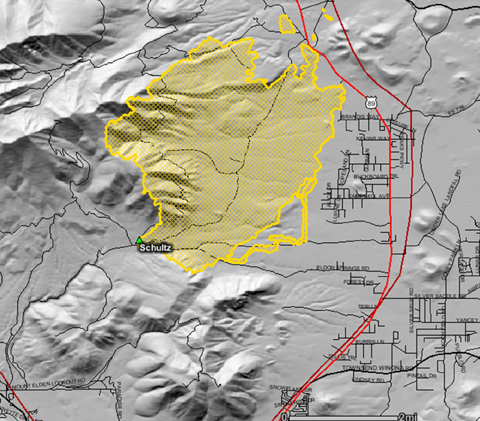
Schultz Fire as of 06/22/2010 at 4 a.m. Map courtesy GEOMAC Wildfire Viewer [here].
The fire was ignited two days ago by a campfire in the Schultz Pass vicinity. It quickly burned to the top of of Schultz Peak and then headed northeast toward subdivisions north of the city.
It is not the first fire to burn through the area. In 1977 the Radio Fire burned 5,000 acres on Mt Elden, the legacy of which is still visible [here]. In 1996 the Hochderffer and Horseshoe Fires north of the San Francisco Peaks burned a total of 25,000 acres.
The extreme fuel conditions directly upwind from Flagstaff have not gone unnoticed:
Fire heads toward Peaks; Inner Basin threatened
by CYNDY COLE, AZ Daily Sun, June 21, 2010 [here]
The wildfire now burning northeast of Pass is larger in area than the whole base of Mount Elden. And it could overrun Lockett Meadow at the foot of the Inner Basin of the San Francisco Peaks, say fire officials, who plan to spend at least a week fighting it.
If it goes there, fighting it will likely be tough going, with dense trees, little physical access for heavy equipment and steep terrain, said the individual in charge of firefighting operations.
This fire, when finished burning, will very likely be among the five largest in Flagstaff’s recorded history. It sits partially in an area where forest thinning was planned but had not yet commenced.
The fire had charred 10,000 acres by Monday evening and forced the evacuation of hundreds of residences along the western side of the Highway 89 corridor. …
The topography of Schultz Pass tends to exacerbate these winds, acting like a chimney, and making it a past priority for thinning.
Firefighters and some people living in Timberline have long seen the pass as a problem area, and it received some renewed attention during the 1996 fire season, when the Hochderffer and Horseshoe fires north of the San Francisco Peaks burned a total of 25,000 acres.
“This is a fire that we’ve talked about for 30 years,” Summit Fire Chief Don Howard told an audience of the public gathered at Coconino High School on Monday night. “We knew it would happen — we always hoped it wouldn’t happen — due to this pass’ ability to push wind.”
After 25 years of constant pressure from Dr. W. Wallace Covington of Northern Arizona University, his Ecological Restoration Institute [here], and a community group [here], a total of 193 acres were thinned in the area.
The Schultz Fire could easily burn 50,000 acres before it is controlled.
Who’s fault is that? Certainly not Dr. Covington’s. He could not have done more to warn the city and to provide solutions.
The fault lies with the people who have fought against fuel treatments and restoration for decades, groups such as the Sierra Club, Earth First!, the Grand Canyon Trust, Arizona Wildlife Federation, Earthjustice, Environmental Fund for Arizona, The Conservation System Alliance and other organizations with various shifting names and websites.
Will the anti-restoration groups be held accountable? Not likely.
A wise and knowledgeable friend writes, “We’ve been here before. Learn nothing, forget nothing. … It may be news, but it’s nothing new.”
And so it goes. Fire returns to Flagstaff, as it does so often in so many locales. Panic fills hearts. People evacuate. Umpteen $millions are spent on dangerous and expensive measures to save homes and lives. Damages exceed the fire suppression outlays by 10, 20, even 50 to 1.
We could do better. We could use sensitive and scientific restoration forestry to save homes, lives, watersheds, and landscapes. Unfortunately there is a (largely political) movement that fights against and sabotages restoration efforts, that promotes catastrophic holocaust, that wishes to Burn Baby Burn no matter how tragic and destructive the outcomes.
If responsible people with common sense do not insist on appropriate land stewardship, the crazies will prevail, and disasters will continue to visit our communities.
Kaibab NF Responds Poorly to Eagle Rock Fire
The Eagle Rock Fire [here] was discovered by local residents last Tuesday two miles west of Spring Valley, AZ. The fire was less than 10 acres when reported, but the Kaibab National Forest failed to respond for nearly 18 hours. By then winds had whipped the fire into a major conflagration.
Last evening the Eagle Rock Fire was estimated to be 3,420 acres, with 626 personnel fighting the fire under the direction of the Northern Arizona Type 2 Incident Management Team. Over $1.6 million has been spent on suppression so far. If the Kaibab NF had responded with rapid initial attack when the fire was reported, the South Fork Fire could have been kept under 50 acres with suppression costs under $100,000.
Forty homes are threatened; about a quarter of those were evacuated. The evacuations have been lifted as the NAZ 2 IMT has the fire 50% contained. Residents are unhappy, however, with the delayed response (note that some of the statistics in the following news article are dated):
Residents: Forest Service blew it with wildfire response
by CYNDY COLE, Arizona Daily Sun, June 19, 2010 [here]
U.S. Forest Service officials headed to meet a displeased crowd in Parks on Friday evening as 533 firefighters continued to work a 3,415-acre wildfire 11 miles north in Spring Valley.
Evacuations had been mostly lifted as of midday Friday, and firefighters were building lines on the fire’s steep southwestern slopes.
Firefighting costs on the blaze — believed to have been started by lightning — were at $400,000 and growing as of Friday morning.
Spring Valley residents complained on Friday that their early reports of a wildfire went unanswered Tuesday evening, before wind-whipped flames charred a thousand acres Wednesday and threatened 40 structures.
As many as a half-dozen people may have called in the fire to the dispatch center, according to residents contacted Friday by the Daily Sun.
Kaibab National Forest officials contend they received fewer calls to the dispatch center’s voicemail system and that callers should have been dialing 911 instead.
LEFT VOICEMAIL AT 7:30 P.M.
One resident who is upset is Bob Rike, whose friend, Bill Griffin, was hiking near Eagle Rock Tuesday evening and spotted a small wildfire.
Griffin told Rike, who said he reported the fire to the Kaibab National Forest that evening.
Rike’s phone message, left at about 7:30 p.m., sat in voicemail for about 12 hours until a Kaibab National Forest employee arrived to check it the next morning, then called Rike asking for more directions.
“I told them where it was again. And 30 minutes later a man called me and said, ‘You reported this fire this morning and I can’t find it,’” Rike said.
Another resident told Rike he had given the firefighters coordinates to the fire and directions, taken with a global-positioning unit.
Then, Griffin agreed to meet firefighters on Spring Valley Road to lead them to the fire.
“When they met there, Bill was looking at the smoke, and he said to the man ‘Look, there’s the fire. Do you see it now?’ And he said, ‘Oh, (expletive),’” said Rike. …
RESPONSE LAGGING IN PAST
For Mayhew and several others, this latest fire was disappointing.
Mayhew reported another fire on forest land near his house last year. He and his wife fought it for an hour before the nearby fire watchtower saw it.
“We went out and put it out and someone showed up after I put it out. This is typical,” he said. “… I was thinking, ‘How could the lookout not see that? It’s right there.’”During the very large Pumpkin fire some years before that burned toward Highway 180, Mayhew and another person reported the fire, then headed to where it was burning, waiting for a response.
“We just sat there for an hour or two, but nobody showed up, and we left,” he said.
So when he heard about the fire on Wednesday, he called the Coconino National Forest instead of the Kaibab, hoping for a different response. …
Vilsack Selects Advisory Committee to Evaluate Collaborative Forest Landscape Restoration Proposals
USDA News Release No. 0329.10, June 18, 2010 [here]
Washington, D.C. - Agriculture Secretary Tom Vilsack today announced the selection of 15 advisory committee members to evaluate Collaborative Forest Landscape Restoration proposals.
“The newly appointed Advisory Committee will serve as the eyes and ears for local and rural communities to ensure USDA provides healthy forests and waterways which will help create green jobs and economic prosperity for our communities,” said Vilsack. “The Committee’s guidance will be invaluable in evaluating landscape restoration proposals that ultimately promote healthier, safer and more productive public lands.”
The Advisory Committee, which was established by the Forest Landscape Restoration Act, signed into law as part of the Omnibus Public Land Management Act of 2009, establishes a collaborative process that relies on the best-available science to plan and prioritize landscape-scale forest restoration projects that benefit local economies. To make large-scale, long-term restoration projects feasible, Congress appropriated $10 million this year in a national fund that will supplement local resources and leverage non-Federal support for carrying out the projects under the CFLR Program.
The program is a key part of the Secretary’s restoration vision for the forests and rangelands under the care of the USDA Forest Service as he laid out in his Seattle speech August 14, 2009. The program is proposed for $40 million in the President’s FY 2011 budget. Quote from Chief … something like … “Combined with the Integrated Resource Restoration budget line proposal, the CFLR Program enables the agency to focus on improving forest and rangeland health and resiliency so we can deliver the goods and services expected from the public lands.”
The 15 members were selected from 59 candidates responding to the Secretary’s request for nominations March 5.
Advisory committee members were selected based on their technical expertise, points-of-view represented, geographic region of the country and diverse backgrounds.
The members will review community based proposals and advise the Secretary concerning their selections.
The USDA Forest Service received 31 proposals from across the country for the committee to evaluate. Project proposals cover a myriad of ecological restoration treatments to reduce wildfire risk, enhance fish and wildlife habitats, maintain and improve water quality and use woody biomass and small-diameter trees. Many of the landscape proposals include contributions from partners and commitments from adjacent landowners to treat their lands.
The Advisory Committee is expected to make final recommendations to Secretary by August 2010.
Primary Committee Members:
Julia Altemus, Missoula, Montana
Maia J. Enzer, Portland, Oregon
Karen Hardigg, Anchorage, Alaska
Brian Kahn, Helena, Montana
James Kennamer, Edgefield, South Carolina
Paige Lewis, Boulder, Colorado
Gary Nakamura, Redding, California
Dr. Brent Racher, Corona, New Mexico
Philip Rigdon, Silverton, Oregon
Dr. Melissa Savage, Santa Fe, New Mexico
Todd Schulke, Tucson, Arizona
Gary J. Severson, Breckenridge, Colorado
Scott Simon, Little Rock, Arkansas
Ray Vaughan, Montgomery, Alabama
Frederick Weyerhaeuser, Cambridge, Massachusetts
Climate Isn’t Responsible For Everything
World Climate Report [here] is World’s Longest Running Climate Change Blog. Much to the credit of its producers, WCR is an amazing source of excellent information on climate science. I highly recommend it. I am particularly interested in WCR articles related to forests, of which there are a goodly number.
There are many sub-issues that relate climate to forests, one of which is: how does climate change affect forest fires? Two articles at WCR on that topic are: Raining on Boreal Forest Fires, June 14, 2010, [here] and Wildfires: The Results of Cyclic Oceanic Variations or Global Warming?, March 27, 2007, [here].
The WRC reviews are reasonable, and fairly report the findings in the papers. However, both papers are flawed, as are so many others that deal with this particular question. The fundamental flaw that these papers share is a failure to consider two phenomena that are not related to climate (or weather) at all: biomass and human influences.
Biomass is the stuff that burns in forest fires. Biomass accumulation and continuity across the landscape are the principal factors in fire intensity and areal extent.
The chief human influence on forest fires has been ignition, deliberate and accidental, for millennia. Human beings are the only animal that makes fire, and we do so and have done so on every continent (save Antarctica) for the entire time we have been there. In the case of North and South America, for at least 13,500 years, the entire Holocene and part of the Pleistocene as well.
Forest fires occur in all climates, from tropical to boreal, wherever there are forests. They can occur in any season at any temperature, although inter-annual wet and dry cycles are key factors. Generally forest fires are less intense and smaller in wet seasons than dry. However, that is not always the case. What is always the case is that fuels (biomass) must be sufficient and continuous across the landscape for forest fires to occur.
What is also very often the case is that human beings lit the fire. The frequency, location, and season of fire is usually due to people, or hs been due to people in the past. Modern man is still a fire starter, but we also have developed fire suppression capabilities. So now we start and stop fires. It’s our choices both ways — the climate and climate change have little or nothing to do with it.
Those key factors, biomass and human ignition, overwhelm the influence of climate and certainly of climate change. That is, forest fires occur in every climate and during every climate cycle, and the key drivers (most significant explanatory variables) are biomass and people.
The papers cited above attempt to find climate phenomena as key variables in wildfire frequency and extent. Without going into detail, those findings are weakly supported by weak evidence, and the papers fail to even consider the actual key factors, biomass and people.
With all due respect to climate folks, they are barking up the wrong tree. There is an unhealthy tendency in climate science to look for, and find, climate to be a driver of all sorts of phenomena, from acne to prostitution. Some of those studies are laughable indeed. It just so happens that wildfire is another of those inferential stretches of climate science, but perhaps not so amusing.
One paper of interest on this topic is
Kay, Charles E. Are Lightning Fires Unnatural? A Comparison of Aboriginal and Lightning Ignition Rates in the United States. 2007. in R.E. Masters and K.E.M. Galley (eds.) Proceedings of the 23rd Tall Timbers Fire Ecology Conference: Fire in Grassland and Shrubland Ecosystems, pp 16-28. Tall Timbers Research Station, Tallahassee, FL. [here].
Dr. Kay found that,
[A]boriginal ignition rates were 270 to 35,000 times greater than known lightning ignition rates. Thus, lightning-caused fires may have been largely irrelevant for at least the last 10,000 years. Instead, the dominant ecological force likely has been aboriginal burning.
Oregon’s Forest Atlas 2010 online edition
Note: The Oregon Forest Atlas 2010 is online. Very interesting, very colorful maps. And some data to go along with them. Thanks to JG for the tip.
The Oregon Forest Atlas project [here] was developed in 2010 to provide public members with a broader understanding of Oregon’s forests using contemporary technology. Maps developed for the Forest Atlas use Geographic Information Systems (GIS) data obtained by the U.S. Forest Service PNW Research Station, data from Oregon State University and data gathered and maintained by the Oregon Department of Forestry.
Maps include:
MODIS Satellite Images of Oregon
Oregon Forestland Generalized Geology
Oregon Forestland Historic Vegetation - 1850
Oregon: Generalized Land Cover
Oregon Land Use
Oregon: Ecological Systems Habitat Types
Oregon Forestland - All Sources
Major Land Resource Areas
Oregon Forestland Site Productivity
Oregon Forestland Ownership
Oregon Forestland Management Classes
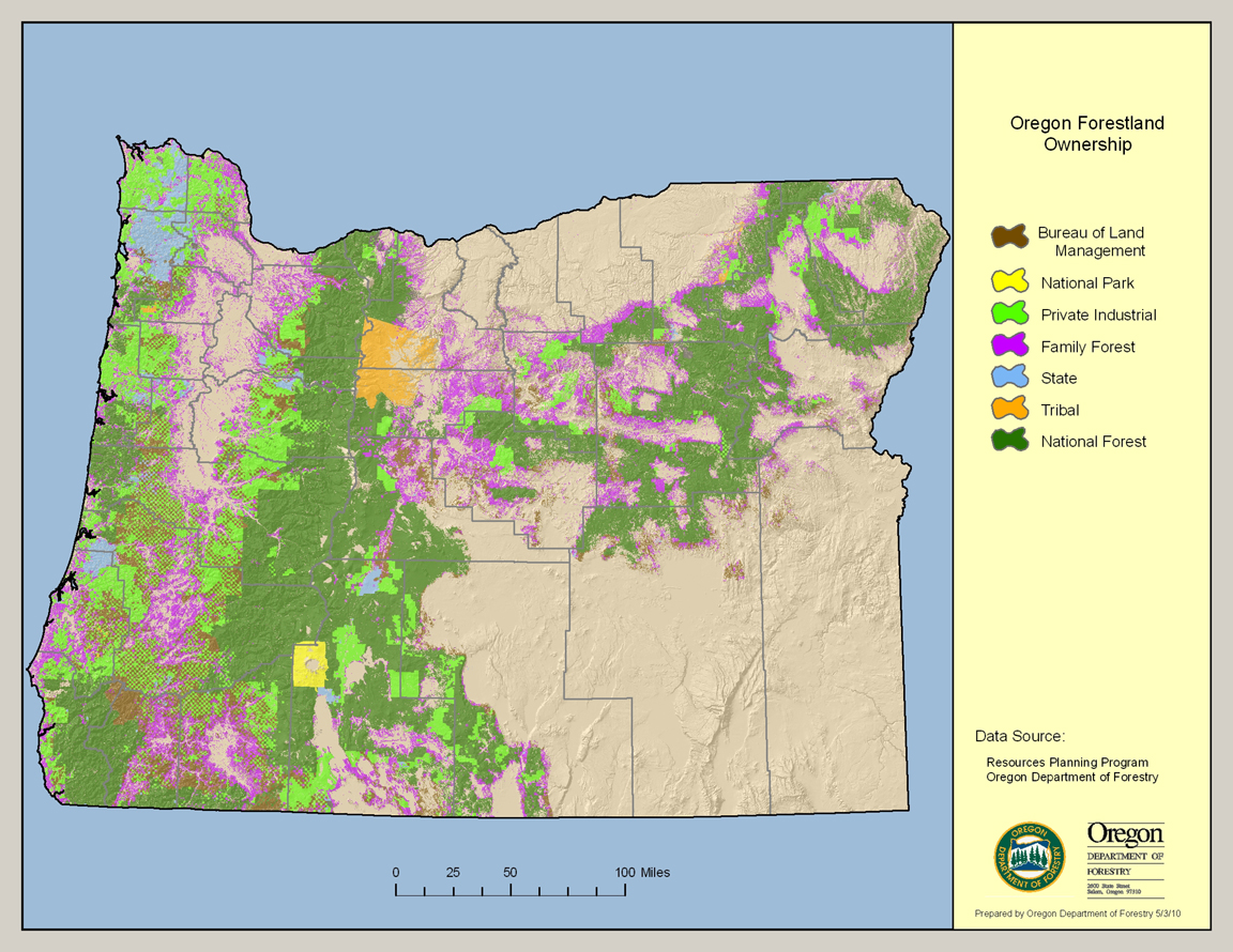
This map depicts Oregon’s forest coverage – 30,472,000 acres – expressed by whether the landowner is the federal government, State of Oregon, tribal governments, family/small woodland owners or private industrial timber producers. Data sources are the U.S. Forest Service PNW Research Station in Corvallis, the Oregon Institute for Natural Resources at Oregon State University and the Oregon Department of Forestry. Click for larger image. For full-sized image visit Oregon’s Forest Atlas 2010 online [here].
The Oregon Forest Atlas is intended to serve as an education and research tool to improve the understanding of public members regarding the attributes of among Oregon’s greatest natural resource assets, our forests.
Data for the Forest Atlas was compiled by staff with the Oregon Department of Forestry in 2010 using data generated by the U.S. Forest Service PNW Research Station in Corvallis, Oregon State University and the Oregon Department of Forestry.
The map products have been produced in the public domain by the State of Oregon. You may download, use, and copy the materials found within the Oregon Forest Atlas website for your personal, noncommercial or educational use, provided that all copies that you make of the material must bear data source attribution information for the material being copied.
This product is for informational purposes, and may not be suitable for legal, engineering or surveying purposes. This information or data is provided with the understanding that conclusions drawn from such information are the responsibility of the user.
Data contained within the map products does not necessarily reflect conditions at a fine-detail level. Some data models rely on site information at least one year old.
All information published herein is gathered from sources which are thought to be reliable, but the reader should not assume that the information is official or final, especially for the purposes of land use determination. The Oregon Department of Forestry does not assume responsibility for errors, and all research information contained within the website is subject to change without notice.
The materials within the Oregon Forest Atlas web site are provided to the public free of charge, “as is” without warranty of any kind, either expressed or implied, including, but not limited to, the implied warranties of merchantability, fitness for a particular purpose, or non-infringement.
Federal forest policy Monkeywrenching forests Politics and politicians Useless and Stupid
by admin
1 comment
Idaho RINOs Back to the Drawing Board
Idaho Governor Butch Otter has put the kibosh on The Blueprint For Destroying Idaho [here]. Pro-holocaust Republicans-in-name-only Rep. Mike Simpson and Sen. Mike Crapo have been sent back to the drawing board.
Boulder-White Clouds bill still needs work, Idaho lawmakers tell Senate panel
Even the wilderness legislation’s architect, Mike Simpson, agrees there’s room for improvement.
BY LAUREN FRENCH, Idaho Statesman, 06/17/10 [here]
WASHINGTON - While it’s a compromise, the latest version of the Boulder-White Clouds wilderness bill can still use refinement, some members of Idaho’s congressional delegation say.
Rep. Mike Simpson and Sen. Mike Crapo, Idaho Republicans who back the measure, acknowledged during a hearing Wednesday that it is far from perfect. And Sen. Jim Risch, R-Idaho, who sits on the Senate subcommittee now considering the bill, said “there are still some pending issues that are going to need, perhaps, some more of that collaborative process to reach this consensus.”
The bill would designate 332,775 acres in the Boulder-White Cloud mountain ranges as three wildernesses, separated in part by motorized trails.
Advocates for recreation say much of the land is already under federal protection, and they don’t like the curbs the bill would place on other trails. Gov. Butch Otter opposes the bill, saying Idaho doesn’t need more wilderness. …
So Simpson’s grand scheme to Burn Baby Burn Idaho (and Montana) is in limbo now, hanging in abeyance like a side of beef in a meat locker waiting for the mad cow test.
Holocausters like to layer on “protection” like ugly wallpaper. Except the “protections” they offer don’t protect, they endanger.
The land in question has already been stolen from the rightful owners by imperialists. Now, instead of practicing good stewardship, the imperialists want to torch the land they seized in a gesture of bullheaded Mussoliniism.
more »
Station Fire Questions Not Going Away
The LA Times continues to probe alleged mistakes made in fighting the Station Fire [here, here]. Last September the Station Fire (Angeles NF) burned 160,600 acres, and destroyed 90 homes. Two Los Angeles County firefighters were fatally injured during the fire. The Station Fire was the largest fire in LA County history, cost nearly $100 million in suppression expenses alone, and inflicted economic damages of 10 to 50 times that amount.
U.S. failed to fill order for aircraft in Station fire
The agency didn’t press to get tankers in the air quickly, despite its own commanders’ urgent request, records and interviews show.
By Paul Pringle, Los Angeles Times, June 16, 2010 [here]
The U.S. Forest Service failed to fill an order for air tankers that its own commanders urgently requested for an assault on the disastrous Station fire before it began raging out of control, according to records and state officials — a finding that rebuts months of assertions by the federal agency that it took every step to deploy the planes as quickly as possible.
The state Department of Forestry and Fire Protection said it could have made as many as four tankers available to the Forest Service on the fateful second morning of the blaze. Two could have reached the fire by 7 a.m. and a third shortly after 7:30 a.m., but the Forest Service did not order them, said Janet Upton, a spokeswoman for the state agency, known as CalFire.
“We never received an order for the aircraft,” she said.
An early assault by the heavy tankers could have helped ground crews contain the blaze that morning, when it was still small, firefighters at the scene have said. The fire jumped a key defense line about 8 a.m. and spread rapidly. It eventually killed two firefighters, destroyed scores of structures and became the largest fire in Los Angeles County history. …
Former Forest Service officials and other experts termed the failure to fill the tanker order a monumental error. They said it was unfathomable that the agency could have overlooked such a critical misstep in its official review of the blaze, a probe that found no faults in the management of the fire fight.
“It’s an absolute cover-up,” said Don Feser, the Forest Service’s former fire chief for the Angeles.
He said Congress should investigate whether the order was deliberately not placed, perhaps as a cost-saving measure. Three weeks before the Station fire, the Forest Service issued a memorandum directing its supervisors to keep expenses down by limiting use of aircraft and ground crews from other agencies. …
Most of the questions about how the fire became so destructive have focused on the absence of a fierce air attack in the hours after dawn on Day 2. The flames had been nearly contained the evening before, in part because of a sustained pounding by helicopters and planes. …
The Times has reported that deployment documents showed the tanker request had been canceled. Noiron said the request was marked canceled by mistake because, due to “messy paperwork,” a dispatcher identified it as a duplicate of the order placed later in the morning.
By the time the planes were over the flames, the fire had scaled Angeles Crest Highway, a crucial battle line, and was exploding through tall trees and paper-dry brush. … [more]
Monkeywrenching forests Politics and politicians Useless and Stupid
by admin
1 comment
The Wildlands Project Bill
It was hidden in Kerry-Lieberman 1,000-page Cap-and-Tax Bill introduced in May [here], but now the Wildlands Project has it’s own special bill, HR 5101, the Wildlife Corridors Conservation Act of 2010.
The Wildlands Project is the brainchild of the radical monkeywrencher group Earth First!. Their burning desire is to “set aside” 90% of the land area of the West in “core reserves” and “wildlife corridors” where human activities such as land stewardship and firefighting would be banned. The Wildland Project also calls for pan-ethnic cleansing, since much of the targeted lands are privately owned and currently inhabited by human residents, aka American citizens.
For a thorough examination of the Wildlands Project see The Wildlands Project, A Country Girl’s Musin’ by Judy Keeler [here]. Another good source of info is Montanans For Multiple Use [here].
The Wildlands Project has nothing to do with Global Warming, and Kerry-Lieberman Cap-and-Taxilla doesn’t either. It’s a power grab; hence the name “The American Power Act” [here]. But Cap-and-Taxilla is unlikely to pass, so the holocauster anti-humanists extracted the Wildlands Project language and set up their own bill.
The sponsors are Rep Rush D. Holt, (D-NJ), Rep Maurice D. Hinchey, (D-NY), Rep George Miller, (D-CA) and Rep Jared Polis, (D-CO). Polis is a mass of contradictions that I don’t even want to get into, see [here]. The rest don’t live within 1,000 miles of the affected landscape and are well-known radical leftists.
The text of HR 5101 is [here].
Norm M. writes:
This bill is intended to lead to the formal creation of several continental-scale wildlife corridor systems that include core habitat, connectivity, and buffer systems. Please read it carefully and spend some time considering what its passage would mean to your livelihood and interests.
If you hate the Human Race and love regional holocausts, this bill is for you. Please send us your name and address so we can add you to our list.