Schultz Fire
Location: 5 mi N Flagstaff, Coconino Co. AZ
Specific Location: Schultz Pass area near junction of FR 420/556 Lat 35° 27´ 16″ Lon 111° 37´ 26″
Date of Origin: 06/20/2010
Cause: Human
Situation as of 07/09/2010 4:00 pm
Personnel: 0
Size: 15,075 acres
Percent Contained: 100%
Costs to Date: $9,290,000
Final 209. Fire within containment lines smoldering and consuming interior fuels. Suppression rehab complete, awaiting BAER work to commence.
***************
Situation as of 07/05/2010 3:00 pm
Personnel: 96
Size: 15,075 acres
Percent Contained: 100%
Costs to Date: $9,180,785
Continue support of district Resource Advisor and BAER Team.
***************
Situation as of 07/03/2010 3:00 pm
Personnel: 119
Size: 15,075 acres
Percent Contained: 100%
Costs to Date: $8,898,117
Fire behavior exhibited low intensity smoldering with isolated interior heavy fuel consumption. Continue mop up and rehabilitation. Work in 200 feet on West Flank, surpress hotspots.
***************
Situation as of 07/01/2010 6:00 pm
Personnel: 125
Size: 15,075 acres
Percent Contained: 100%
Costs to Date: $8,613,389 (no update)
Transitioned from D. Hughes Type 1 Team to the ALBQ Zone Type 3 Team (R. Romero IC). New ICP established at Summit Fire Station 33. BAER team flew fire with district READ to finalize BAER guidelines.
***************
Situation as of 06/30/2010 4:40 pm
Personnel: 357
Size: 15,075 acres
Percent Contained: 100%
Costs to Date: $8,613,389
100% containment reached today. Transition to a Type 3 Team is on schedule for Thursday July 1, at 0600.
***************
Situation as of 06/29/2010 4:30 pm
Personnel: 489
Size: 15,075 acres
Percent Contained: 90%
Costs to Date: $8,291,164
BAER team engaged.
***************
Situation as of 06/28/2010 5:00 pm
Personnel: 597
Size: 15,075 acres
Percent Contained: 75%
Costs to Date: $7,640,173
APS completed repairs to burned poles and re-energized the powerline yesterday. Fire management objective is full suppression, as dictated by proximity to residences, infrastructure, and high value recreational resources. Steep terrain of the west flank will continue to challenge logistics of winding down control operations as the goal of full suppression is approached. Transition to a Type 3 Team is on schedule for Thursday June 28, at 0600.
***************
Situation as of 06/27/2010 5:00 pm
Personnel: 626
Size: 15,075 acres
Percent Contained: 65%
Costs to Date: $6,976,561
Plans to transfer the fire to the local agency on Thursday morning, July 1, 2010, at 0600.
***************
Situation as of 06/26/2010 4:30 pm
Personnel: 748
Size: 15,075 acres
Percent Contained: 55%
Costs to Date: $6,753,551
Line construction is complete. Continue to improve line and mop up on the SW and NW flanks of the fire. Continue to patrol, and mop up on the NE, E, and SE flanks.
***************
Situation as of 06/25/2010 4:40 pm
Personnel: 901
Size: 15,000 acres
Percent Contained: 50%
Costs to Date: $5,832,046
Significant progress was made on the SW and NW flanks of the fire due to significantly higher humidities, cloud cover, and lower than expected wind speeds. Precipitation in the form of showers (less than .1 of an inch) was reported on the SW flank today.
***************
Situation as of 06/24/2010 5:00 pm
Personnel: 947
Size: 14,800 acres
Percent Contained: 40%
Costs to Date: $5,000,786
Structures Destroyed: NONE
An additional 500 acres burned yesterday with crown fire and large smoke plume lasting 1 to 2 hours. Continue to construct, improve, and burn out line on the southwest, and northwest flanks of the fire. Continue to patrol, and mop up on the northeast, east, and southeast flanks.
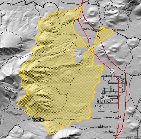
Fire perimeter 6/25/2010, from GEOMAC.
***************
Situation as of 06/23/2010 5:10 pm
Personnel: 961
Size: 14,300 acres
Percent Contained: 25%
Costs to Date: $2,960,367
Structures Destroyed: NONE
Residents west of highway 89 were allowed to return at 0800 today. Sunset Crater National Monument reopened.
Fire behavior was moderate due to reduced wind speed and high night time RH recovery. Majority of fire growth due to aerial ignition and backburn. Continue to construct, improve, and burn out line on the southeast, and northwest flanks of the fire. Continue to patrol, and mop up on the northeast, east, and southeast flanks.
***************
Situation as of 06/22/2010 5:30 pm
Personnel: 947
Size: 14,000 acres
Percent Contained: 20%
Structures Threatened: 1,000 PRIM , 100 COMM , 500 OUTB
Highway 89 was opened for travel. Evacuations are still in effect for structures west of highway 89. No growth towards evacuated structures on the east flank of the fire. Fire behavior was moderate during the day compared to the higher rates of spread and intensities observed late afternoon and early evening yesterday. Moderate growth was do mainly to reduced wind speeds. Governor Brewer visited EOC for media briefing.
***************
Update 6:00 pm June 22, 2010 (source AZ Daily Sun [here]): fire mapped at ~14,000 acres, 20% contained. 800+ firefighting personnel engaged. Air tanker sorties aided suppression efforts. Evacuation orders still in effect.
Situation as of 06/21/2010 6:00 pm
Personnel: 672
Size: 10,000 acres
Percent Contained: 10%
Structures Threatened: 1,000 PRIM , 100 COMM , 500 OUTB
Hutchinson Acres was evacuated today in the SE fire area. Most fire behavior was confined to indirect backburns in the north and south initiated the night before. No growth towards structures on the east flank of the fire.
Fire management objective is full suppression, as dictated by proximity to residences, infrastructure, and high value recreational resources. Steep terrain of the west flank will continue to challenge suppression. Crews made good progress on the east flank protecting structures during the last operational period.
***************
Update 5:00 pm June 21, 2010 (source AZ Daily Sun [here]): fire mapped at ~10,000 acres. 400+ firefighting personnel engaged. Cause determined to be an abandoned campfire near Schultz Tank and Elden Trail. Fire officials are seeking tips and information on any incidents or about anybody camping in the area at 527-3600.
Evacuations expanded to residences on roads extending south off Campbell Avenue (and west of Highway 89) in a neighborhood known as Hutchinson Acres. Fernwood Estates remains on standby. No structures have been lost as of noon today.
Air tankers fighting the Schultz fire burning out of Schultz Pass and into Timberline area were grounded in the early afternoon, with the expectation of continuing high winds this afternoon will likely keep them on the ground. However, they were able to get in limited runs later on as conditions permitted.
North Highway 89 remains closed north of Silver Saddle Road, 5 miles north of Flagstaff, to through traffic. It has been opened intermittently to allow for sheriff’s escorts of evacuated residents.
Update 9:00 am June 21, 2010: Fire size now 8,849 acres. High winds pushed the fire Sunday. There is zero containment. Eight airtankers were grounded by high winds from 1:30 to 7 p.m. No structures have been reported damaged or destroyed, and no injuries were reported. U.S. 89 remains closed.
Situation as of 06/20/2010 9:00 pm
Personnel: 300+
Size: 5,000 acres
Percent Contained: 0%
The Schultz Fire was reported at approximately 11:00 Sunday morning, and is located in the Schultz Pass area on the southeast side of the San Francisco Peaks. Crews are faced with hot, dry weather and high winds. As of 6:00 pm Forest officials believe the fire is approximately 5000 acres. Approximately 300 firefighters are on scene, additional fire resources are en route. Currently there are 8 air tankers and 5 helicopters assigned. The Southwest Type 1 Incident Management Team, Dugger Hughes Incident Commander, is en route and scheduled to assume management of the fire Monday, June 21 at 6:00 am.
Evacuations: All areas north of Campbell Ave. and west of Highway 89 have been issued evacuation orders including Wupatki Trails subdivision; Timberline Estates subdivision, Sunset Crater National Monument; Second Chance Animal Shelter (animals safely evacuated to Fort Tuthill County Park); and there is no mandatory evacuation of Fernwood subdivision, although some residents have left. Over 1,000 homes evacuated as of 10 pm Sunday.
Closures: State Highway 89 is closed from MP 433 (2.5 miles north of Sunset Crater National Monument) to Silver Saddle Road.
