Cottonwood Fire
Location: 1 mile E of Cranston and 10 miles E of Hemet, Riverside Co., CA
Specific Location: San Bernardino NF, ~Lat 33° 44´ 09″ ~Lon 116° 49´ 52″
Date of Origin: August 27th, 2009
Cause: Power pole related, investigation ongoing
Situation as of 08/31/2009 8:00 pm
Personnel: 368
Size: 2,409 acres
Percent contained: 100%
***************
Situation as of 08/27/2009 8:00 pm
Personnel: not reported
Size: 400 acres
Percent contained: 5%
Highway 74 is closed and voluntary evacuations are in progress in the vicinity of Bee Canyon.
Canal Creek Fire
Location: 8 miles SW of Detroit, Marion Co. OR
Specific Location: Elk Creek drainage, trib to Canal Creek, trib to Quartzville Creek, Sweet Home RD, Willamette NF, ~Lat 44° 37´ 14″ ~Lon 122° 19´ 04″
Date of Origin: 08/26/2009
Cause: Under Investigation
Situation as of 09/11/2009 11:30 am
Personnel: 117
Size: 283 acres
Percent contained: 96%
Costs to date: $5,385,000
***************
Situation as of 09/10/2009 2:00 pm
Personnel: 117
Size: 283 acres
Percent contained: 96%
Costs to date: $5,291,000
***************
Situation as of 09/08/2009 6:00 pm
Personnel: 189
Size: 283 acres
Percent contained: 95%
Costs to date: $5.1 million (est.)
Quartzville Road (#11) and Kinney Creek Road (#2212) are open.
***************
Situation as of 09/06/2009 7:00 pm
Personnel: 222
Size: 283 acres
Percent contained: 90%
Costs to date: $4,900,000
Rain over the fire area Saturday and Sunday, further reducing active burning.
***************
Situation as of 09/05/2009 8:50 am
Personnel: 356
Size: 283 acres
Percent contained: 80%
Costs to date: not reported
The Type 2 Incident Management Team will transistion to a Type 3 Organization today. Rain is expected over the fire area today and tomorrow, further reducing active burning.
***************
Situation as of 09/04/2009 8:30 am
Personnel: 374
Size: 283 acres
Percent contained: 50%
Costs to date: not reported
Minimal fire behavior was observed yesterday. Crews continue direct containment line construction on the N edge of the fire. Firefighters are monitoring the SE corner of the fire and a spot fire to the E.
***************
Situation as of 09/03/2009 11:00 am
Personnel: 427
Size: 283 acres
Percent contained: 35%
Yesterday fire crews held the fire against high temperatures, lower relative humidity, steep slopes, and falling snags. One of the challenges was burning material rolling downhill. Today winds from the SW are expected and could hinder air support.
Several closures have been issued for the area of roads bound by Forest Road 11, also known as Quartzville Road, to the south, Forest Road 1131 to the west, Forest Road 1133 to the east and Forest Road 2212, also known as Kinney Creek Road, to the north at Detroit Dam. Recreation is not permitted within the closure area. The public is asked to avoid the fire area due to heavy fire traffic and concerns for public safety.
***************
Situation as of 09/01/2009 5:00 pm*
Personnel: 473
Size: 283 acres
Percent contained: 25%
*Reports from the NW Interagency Coordination Center have been 24+ hours late all year. Other GACC’s don’t have that problem. Something is amiss at the NWCC. Their contact info is:
NWCC Contact Information
Phone: (503) 808-2720
Admin Fax: (503) 808-2789
Operations Fax: (503) 808-2750
Email: ornwc@dms.nwcg.gov
Please call them and ask them what their main incompetency problem is.
Costs to date: $3,100,000**
**So far the agencies involved have spent more than $1,000 per acre on this small fire that has been burning for a week. It is still only 25% contained. Private and public forest lands are at risk. The appearance of a) incompetence, b) milking the taxpayer, or c) both, cannot be denied.
***************
Big Meadow Fire
Location: Foresta, 3 miles NE of El Portal, Mariposa Co., CA
Specific Location: Big Meadow, Yosemite NP, ~Lat 37° 42´ 22″ ~Lon 119° 45´ 04″
Date of Origin: August 26th, 2009
Cause: Human (prescribed fire)
Situation as of 09/07/2009 6:00 pm
Personnel: 398
Size: 7,425 acres
Percent contained: 100%
Costs to Date: $15,800,000
The Big Oak Flat Road remains under a hard closure. Crews made good progress falling hazard trees along the Big Oak Flat Road corridor (approx.90% complete). Suppression repair continues on the contingency dozerline in Division B and crews expect to move into Division A tomorrow. Mop-up, patrol and backhaul of all equipment continues in other divisions.
***************
Situation as of 09/07/2009 7:00 am
Personnel: 760
Size: 7,425 acres
Percent contained: 100%
Costs to Date: $15,200,000
Tioga Road opened at 0800. Continued falling hazard trees along Big Oak Flat Road. Big Oak Flat Road continues to be closed.
Isolated pockets of fuel continue to burn out. Scattered heat along fireline.
Shadowing of Team by incoming ICT3. Continued demobilization of crews, equipment, and overhead. Mop-up and patrol in all Divisions. Fire suppression repair continues.
***************
Situation as of 09/05/2009 6:00 pm
Personnel: 851
Size: 7,425 acres
Percent contained: 90%
Costs to Date: $14,300,000
Big Oak Flat Road had a temporary hard closure because of ongoing falling of hazardous snags. Mop-up of perimeter hot spots continues. Utility crews entered the area to perform repairs to restore critical infrastructure to Yosemite National Park and surrounding communities including power and telephone lines. Mop-up and patrol of all divisions.
***************
Situation as of 09/04/2009 6:00 am
Personnel: 1,113
Size: 7,354 acres
Percent contained: 80%
Costs to Date: $11,800,000
Evacuation Order for the community of Foresta was lifted today at 10:00 AM. A line was completed around the slop over in Division F including the spot fires along Tamarack Creek. Falling trees by the fire on roadways. Identify and assess rehab needs.
***************
Harrington Fire
Location: 20 miles SW of Happy Camp, Del Norte and Siskiyou Cos., CA
Specific Location: Harrington Mountain, Klamath and Six Rivers NFs, Lat 41° 40´ 52″ Long 123° 41´ 06″
Date of Origin: 08/02/2009
Cause: Lightning
Situation as of 08/27/2009 5:30 pm
Personnel: 23
Size: 165 acres
Percent contained: 80%
Estimated Containment Date: August 29th, 2009
***************
Situation as of 08/25/2009 8:00 pm
Personnel: 23
Size: 165 acres
Percent contained: 60%
Two fire use modules are spiked on the fire. They will monitor the fire and check any spread outside current perimeter.
***************
Situation as of 08/24/2009 9:00 pm
Personnel: 41
Size: 165 acres
Percent contained: 30%
The Harrington Fire is burning in the Siskiyou Wilderness, east of Harrington Mountain. Fire crews are monitoring the progress of the fire and cooling down hot spots with helicopters dropping water.
The National Incident Management Organization (NIMO) team based in Atlanta, GA is now assisting the Oregon and California (ORCA) IMT on both the Red Rock and Harrington Fires. George Custer will be the overall Incident Commander.
Red Rock Fire
Location: 15 miles W of Fort Jones, Siskiyou Co., CA
Specific Location: Red Rock Creek, Lat 41° 34´ 49″ Long 123° 09´ 00″
Date of Origin: 06/10/2009
Cause: Human (prescribed fire)
Situation as of 09/02/2009 4:30 pm
Personnel: 185
Size: 1,382 acres
Percent contained: 90%
Costs to Date: $4.2 million (est.)
A Type 3 team from the Klamath National Forest has taken over the Red Rock Incident. Continuing to mop-up and downsizing spike camps. The Etna ICP has been shut down and moved to the Salmon/Scott Ranger District office.
***************
Situation as of 09/01/2009 6:00 pm
Personnel: 185
Size: 1,382 acres
Percent contained: 85%
Costs to Date: $3,900,000
Custers NIMO team is still assigned, their planned release is on 9/3/09. Transition to the Type III organization occurred today at 0600. An area closure and two road closures are in place. Lover’s Camp Trailhead is also closed to the public. Type 2 helicopter support is necessary for demob of spike camp resources over next day.
Creeping and smoldering with backing and limited uphill spread. The only activity is located in Division G on the NW side of fire.
***************
Situation as of 08/27/2009 5:30 pm
Personnel: 436
Size: 1,277 acres
Percent contained: 75%
Effective immediately, the area closed is described generally as follows; starting at Paradise Lake to the south along the Pacific Crest Trail (PCT) to Little Marble Valley, then eastward along the PCT to Summit Lake, then northeastward to Big Meadow and up along the Wilderness boundary and around back to Paradise Lake.
Also, two Forest Service roads are closed and are described as followed: Forest Road 44N45 from its intersection with the entrance to Indian Scotty Campground southwest to its intersection with Forest Road # 43N45 and Forest Road 43N45 from its intersection with Forest Road # 44N45 southwest to its termination at Lover’s Camp Trailhead.
The Lover’s Camp Trailhead is also close to the public until the Red Rock Fire is fully suppressed.
***************
Situation as of 08/25/2009 8:00 pm
Personnel: 393
Size: 871 acres
Percent contained: 50%
Fire managers completed all containment lines late today and began the process of installing fire hose and water distribution systems along the fire lines. The NW corner of the fire is burning in the Canyon Creek drainage that contains a dense stand of Shasta Red Fir. The fire is slowly burning along the E edge of the canyon towards Canyon Creek. During the next few days fire crews and helicopters will be initiating small-scale burnout operations under controlled conditions so that the fire slowly backs down the hill. If the fire is allowed to continue under uncontrolled conditions, fire managers are concerned that burning materials will roll/fall to the bottom of the canyon and aggressively burn to the top creating a significant spotting potential far in advance of the main fire. Five heavy-lift capacity helicopters are assisting fire crews by cooling hot spots with water from nearby lakes. There are no private lands or structures immediately threatened by either fire. Eleven fire crews are camping close to the fire at three primitive campsites to minimize travel time and to be more effective while working at the fire. Since these fires are within a Wilderness, minimum suppression tactics are being utilized.
A portion of the Pacific Crest Trail is closed. If you are a PCT hiker, you may take advantage of the following services:
The Etna City Park is available for overnight camping free of charge during this emergency.
You may ride the Stage bus from Etna to Seiad/Seiad to Etna for a total cost of $9.05 (payable by cash or check). Please note that Stage drivers do not make change. The fare between Etna and Yreka is $3.15, and between Yreka and Seiad is $5.90.
GOING NORTH: The Stage leaves from Etna City Hall on Main Street for Yreka every day at 6:45 am, 9:43 am, 12:22 pm, and 3:12 pm. The Stage leaves Yreka for Seiad Valley Mondays and Fridays only, departing from WalMart at 3:20 pm, or from the Stage offices at 4th and Miner Streets in Yreka at 3:28 pm.
GOING SOUTH: The Stage leaves from Seiad Valley at 8:10 am Mondays and Fridays only. The Stage leaves Wal-Mart in Yreka for Etna at 11:32 am and 12:24 pm, and from Price Less Foods (on Main Street) at 5:06 pm.
***************
Situation as of 08/24/2009 9:00 pm
Personnel: 368
Size: 802 acres
Percent contained: 45%
The Red Rock Fire is burning within the Marble Mountain Wilderness south of the Lover’s Camp Trailhead in the Red Rock watershed. It is currently estimated at 802 acres in size and became quite active Friday afternoon during a wind event which generated smoke that could be seen from the Medford/Rogue River Valley area. This fire was started in early June as a prescribed fire to reduce heavy fuels and restore meadow systems and wildlife habitat within the Wilderness. Unexpected winds and very hot and dry conditions gave fire managers challenges which exceeded local fire-suppression capabilities. No private lands or structures are immediately threatened, but the Klamath National Forest called in additional resources and the ORCA IMT to manage the fire. The ORCA IMT will assume command on Sunday at 06:00 a.m.
The National Incident Management Organization (NIMO) team based in Atlanta, GA is now assisting the Oregon and California (ORCA) IMT on both the Red Rock and Harrington Fires. George Custer will be the overall Incident Commander.
Oden Road Fire
Location: 5 miles W of Okanogan, 2 Miles N of Malott, Okanogan Co., WA.
Specific Location: Fox Mountain, Chilliwist Butte, Lat 48° 22´ 46″ Longitude 119° 45´ 36″
Date of Origin: 08/21/2009
Cause: lightning
Situation as of 08/26/2009 8:00 pm
Personnel: 557
Size: 9,607 acres
Percent contained: 90%
Acreage is reduced due to more accurate mapping of fire perimeter using GPS equipment. Crews are working to extinguish hot spots along the fire perimeter and around structure.
***************
Situation as of 08/25/2009 7:30 pm
Personnel: 694
Size: 10,258 acres
Percent contained: 80%
As of Monday evening, there are no evacuation notices in effect, but residents in the area should be aware of the fire situation in the area. Highway 20 is now open to through traffic between Twisp and Okanogan.
***************
Situation as of 08/24/2009 5:30 pm
Personnel: 685
Size: 10,258 acres
Percent contained: 70%
Structures Destroyed: 2 PRIM
Homes were evacuated on Friday, but residents were allowed back in on Saturday. Nearly 200 homes remain on alert to be aware of potentially changing fire conditions. Highway 20 is closed to through traffic between Twisp and Okanogan due to fire activity on both sides of the road, including falling trees and rocks. It will remain closed until safety of travellers can be ensured.
Dry Creek Complex Fires
Location: 2 miles S of Priest Rapids, Yakima and Benton Cos., WA
Specific Location: Rattlesnake Hills, Yakima Military Res., Arid Land Ecological Res., ~4? miles W of Hanford DOE Site, Lat 46° 34´ 46″ Lon 119° 43´ 41″
Date of Origin: 08/20/2008
Cause: lightning
Situation as of 08/24/2008 8:00 am
Personnel: 112
Size: 48,902 acres
Percent contained: 80%
Costs to Date: $850,000
Structures Destroyed: 1 PRIM , 1 COMM
***************
Situation as of 08/22/2008 4:00 pm
Personnel: not reported
Size: 40,000 acres
Percent contained: 0%
The fire is estimated at 40,000 acres, wind-driven and burning in sage brush and grass on Federal and private lands from 6 miles north of Sunnyside N to the Columbia River straddling Hwy 241. Within ~4? miles of Hanford Waste Management and Processing Area.
One structure, the Silver Dollar Cafe located at the intersection of Hwy 241 and Hwy 24, and one manufactured home were lost. There are no evacuation orders currently in place. Hwy 241 is closed between Sunnyside N to Hwy 24, and Hwy 24 is closed from Moxee E to Hwy 240.
Two type 1 heavy helicopters, dozers, and engines are working the fire. State mobilization was ordered and approved at midnight Friday allowing fire resources from across Washington to come and assist the local fire districts. A type 2 WA IMT took over management of the fire at 1800 hrs 08/22.
Hoyt Fire
Location: 45 Miles NE of Fallon, Churchill Co., NV
Specific Location: New Pass Range, Lat 39° 49´ 16″ Long 117° 33´ 33″
Date of Origin: 08/20/2009
Cause: Under Investigation
Situation as of 08/24/2009 5:00 pm
Personnel: 3
Size: 10,685 acres
Percent contained: 100%
***************
Situation as of 08/23/2009 5:00 pm
Personnel: 194
Size: 10,670 acres
Percent contained: 85%
Costs to Date: $1,160,000
Precipitation fell over fire area.
***************
Situation as of 08/21/2009 noon
Personnel: 187
Size: 6,585 acres
Percent contained: 5%
The Hoyt Fire is burning on BLM-administered land in the northeastern portion of the Clan Alpine Mountains in Chruchill County, Nevada. This is about 70 miles northeast of the city of Fallon. The fire is burning in pinyon pine-juniper trees, sagebrush and grass.
Fatality: A single engine air tanker (SEAT) crashed on the Hoyt Fire on Thursday, August 20, at approximately 3:30 p.m. Pilot Dave Jamsa was flown by helicopter to medical facilities in Lovelock, Nevada, were he was pronounced dead. The National Transportation Safety Board and the Federal Aviation Administration in on-scene conducting an investigation.
Suwyn’s Type II Incident Management Team will take over management of the fire at 1800 on Friday, August 21.
Mill Flat Foofurb* Fire
Location: 4 to 5 miles SW of New Harmony, 10 miles W of Zion NP, Washington Co., UT
Specific Location: Mill Flat, Dixie NF, Lat 37° 26´ 18″ Lon 113° 23´ 33″
Date of Origin: 07/25/2009
Cause: Lightning
Situation as of 09/07/2009 7:00 am
Personnel: 75
Size: 12,607 acres
Percent contained: 100%
Costs to Date: $6,500,000
***************
Situation as of 09/04/2009 4:00 pm
Personnel: 688
Size: 12,607 acres
Percent contained: 62%
Costs to Date: $5,000,000
Use of hand crews and engines to mop up line on the N and SE flanks. Helicopters were used to limit fire spread in inaccessible areas. Ground resources continued line construction on the NW and SW flanks; crews will be spiked out. A US Forest Service BAER team is in place.
Flash Flooding Announcement:
New Harmony, Utah - Meteorologists have predicted the potential for flash floods in the area. Residents should be advised that The Natural Resource Conservation Service (NRCS), and the Burnt Area Emergency Response Team (BAER), have made assessments and set priorities in order to minimize risk to problem areas and structures. This includes natural areas and infrastructures. Mitigation measures will include water diversion by building sand bag barriers around affected areas. These areas are in the Dam, Comanche, Strait and Main Canyon drainages.
Residents of the Ash Creek drainage including the area around New Harmony may pick up sand bags at the triangle south of the cemetery in New Harmony. Crews will fill and stock-pile sand bags until midnight today and may continue later if the situation requires.
Julie Woods with New Harmony Valley Fire District will be the Incident Commander in these flood preparation work efforts.
Emergency notification of residents will be through reverse 911. Residents may report any personal emergencies to 911 as well.
Individuals are reminded not to enter or attempt to cross areas that are flooding. Fast moving water is dangerous and even vehicles should not be used in crossing. Stay on high ground until the flooding abates.
***************
Situation as of 09/03/2009 4:00 pm
Personnel: 746
Size: 12,607 acres
Percent contained: 33%
Costs to Date: $4,100,000
Direct line construction will commence on the W, S, and SW flanks.
***************
Situation as of 09/02/2009 4:00 pm
Personnel: 765
Size: 12,564 acres
Percent contained: 33%
Costs to Date: $3,100,000
Use of hand crews, engines and air resources to limit spread on the N and SE flanks to protect structures and infrastructure. Helicopters were used to limit fire spread in inaccessible areas. Ground resources began line construction on NW flank, crews will be spiked out.
***************
Situation as of 09/01/2009 1:30 pm
Personnel: 754
Size: 11,180 acres
Percent contained: 10%
Costs to Date: $2,000,000
***************
Situation as of 08/31/2009 4:45 pm
Personnel: 647
Size: 10,382 acres
Percent contained: 0%
Maximum fire area: 29,000 acres
Structures Destroyed: 3 residences , 8 outbuildings
Community of New Harmony, 150 homes threatened.
Costs to Date: not reported
Transistion to Muir’s IMT 1 at 0600 today. Use of hand crew, engine and air resources to limit spread on the N and SE flanks to protect structures and infrastructure. Fixed-wing air delivered retardant and helicopters were used to check fire spread in inaccessible areas. Initiated scouting and assessment on other flanks to prepare for future actions. Acres by owner- BLM 41ac., Private 440 ac., and USFS 9901 ac. Continued media attention by print and television at both the state and local levels.
This Let It Burn fire blew up and burned private homes far from the ignition point on the Dixie NF. This is the second Let It Burn fire on the Dixie NF this summer that blew up and caused serious damages and costs (see Bridge Fire [here]).To date neither Bevan Killpack, Pine Valley District Ranger nor Rob MacWhorter Forest Supervisor for the Dixie NF have been formally charged with criminal negligence.
*foofurb: euphemism for “fire used for resource benefit.” However, as is usual with foofurbs, no benefits have been elucidated, no EIS created, no public involvement or hearings held.
***************
more »
Elephant Fire
Location: 2 miles SW of Rock Creek, Plumas Co., CA
Specific Location: Plumas NF, Feather River Canyon, E of Hwy 70 between Rock Creek Reservoir and Elephant Butte, Lat 39° 52´ 41″ Long 121° 22´ 12″
Date of Origin: 08/16/2009
Cause: Under Investigation
Situation as of 08/21/2009 5:00 pm
Personnel: 216
Size: 448 acres
Percent contained: 83%
Estimated date of containment: August 30th, 2009
***************
Situation as of 08/20/2009 8:30 pm
Personnel: 320
Size: 437 acres
Percent contained: 75%
***************
Situation as of 08/19/2009 6:30 pm
Personnel: 338
Size: 274 acres
Percent contained: 60%
Tobin Fire is 100% contained. Elephant Fire is 60% contained. Hwy 70 is open with one-lane traffic control and pilot car.
Fire located in a previous fire scar, 1999 Bucks Fire. Primary carrier of fire is brush and dead and down material. Fire moved E along Grizzly Creek and upslope to the S.
Crews completed indirect handline in DIV C; initiated indirect contingency lines in DIVS M. Firing operations to hold fire edge W of tributary to Grizzly Creek.
***************
Situation as of 08/18/2009 8:00 am
Personnel: 381
Size: 185 acres
Percent contained: 60%
Tobin Fire is 100% contained. Elephant Fire is 60% contained. Hwy 70 is open with one-lane traffic control and pilot car.
The fire is is burning at a low to moderate rate of spread in extremely steep, rocky terrain only accessible by foot. Five Type 1 Hot Shot Crews are currently assigned to the fire. During daylight hours firefighters are being assisted by helicopters and air tankers as needed.
***************
Situation as of 08/17/2009 8:00 pm
Personnel: 200
Size: 198 acres
Percent contained: 0%
As of 2:50pm on Monday, Aug. 17, CA Highway 70 open with one-way traffic controls and pilot car from Jarbo Gap in Butte County to the 70/89 Wye in Plumas County. Motorists should check highway information at 1-800-427-7623 or www.dot.ca.gov for current conditions.
NorCal Team 1 (Swartzlander) Type 2 IMT is now managing the fire. Helicopters and airtankers are assisting firefighters on the ground during daylight hours. Fire is burning in extremely rocky and inaccessible terrain east of Highway 70 and south of Grizzly Creek.
***************
Situation as of 08/17/2009 11:45 am
Personnel: 200
Size: 150 acres
Percent contained: 0%
As of 11:00 am, Monday August 17, Highway 70 is closed from the Highway 70/89 “Wye” in Plumas County to Jarbo Gap in Butte County.
Yuba Fire
Location: 1 miles S of Dobbins, Yuba Co. CA
Specific Location: Lake Francis near Colgate Powerhouse, Approx. Lat 39° 20´ 25″” Lon 121° 12´ 19″
Date of Origin: 08/14/2009
Cause: Red-tail Hawk into Powerline
Situation as of 08/23/2009 7:00 pm
Personnel: 76 (no update)
Size: 3,891 acres
Percent contained: 100%
Recreational areas have been re-opened to the public.
CAL FIRE Team #10 transitioned the incident back under the units command on August 21.
***************
Situation as of 08/23/2009 7:00 am
Personnel: 723 (no update)
Size: 3,891 acres
Percent contained: 95%
Expected date of containment: August 23, 2009
Demobilization of resources and personnel is underway. Residents must remain vigilant for changes in fire conditions. Recreational areas have been re-opened to the public.
***************
Situation as of 08/21/2009 6:00 pm
Personnel: 723
Size: 3,891 acres
Percent contained: 95%
Costs to date: $10.7 million
Expected date of containment: August 23, 2009
CAL FIRE Team #10 will transition the incident back under the units command today.
***************
Corral Fire
Location: 10 miles SW of Tracy, Alameda, San Joaquin Co. CA
Specific Location: Mitchell Ravine, Lat 37° 37´ 55″” Lon 121° 32´ 15″
Date of Origin: 08/13/2009
Cause: Under investigation
Situation as of 08/17/2009 7:00 am
Personnel: 199
Size: 12,500 acres
Percent contained: 100%
Costs to date: $ 1.8 million
Continued mop-up and demobilization of resources will occur today.
***************
Situation as of 08/16/2009 7:15 am
Personnel: 331
Size: 12,500 acres
Percent contained: 85%
Costs to date: $ 1.8 million
Full containment expected August 17, 2009. Fire is expected to hold within containment lines. Hot temperatures and winds causing some flare-ups within the established containment lines.
***************
Situation as of 08/14/2009 7:00 pm
Personnel: 335
Size: 15,000 acres
Percent contained: 20%
Fire is expected to continue south/southeast driven by winds that are shifting northward. Temperatures are expected to increase and humidities to drop over the next two days with a subsequent increase in fire behavior.
Cooperating Agencies: CAL FIRE, San Joaquin Fire, Stanislaus Fire, Tracy Fire, Alameda County Fire, Contra Costa Fire, East Bay Parks, CHP, Dept. of Corrections and Rehabilitation.
***************
Situation as of 08/13/2009 11:30 pm
Personnel: 264
Size: 4,000 acres
Percent contained: 10%
***************
Situation as of 08/13/2009 6:00 pm
Personnel: 264
Size: 3,000 acres
Percent contained: 10%
Extreme rate of spread. Near Hetch Hetchy Aqueduct.
Summit Fire
Location: 4 miles W of Fouts Springs, Colusa Co., CA
Specific Location: Snow Mtn, Stoney Creek, Mendocino NF, Lat 39° 20´ 45″ Lon 122° 45´ 5″
Date of Origin: 08/12/2009
Cause: Under Investigation
Situation as of 08/14/2009 6:00 pm
Personnel: 276 (not updated)
Size: 350 acres
Percent contained: 100%
***************
Situation as of 08/13/2009 4:30 pm
Personnel: 276
Size: 350 acres
Percent contained: 40%
Costs to date: $375,000
Moderate growth, continued containment progress, Swartzlander Type II Team will assume command at 1800.
Fairfield Fire
Location: 10 miles SE of Old Station, Shasta Co., CA
Specific Location: Fairfield Peak, Lassen NP, Lat 40° 31´ 19″ Lon 121° 21´ 1″
Date of Origin: 08/02/2009
Cause: Lightning
Situation as of 08/13/2009 5:30 pm
Personnel: 130
Size: 1,000 acres
Percent contained: 0%
Costs to date: $450,000
Closed Pacific Crest Trail, Nobles Emigrant and several other trails for public/fire fighter safety. Wildfire being managed for multiple objectives.
Lockheed Fire
Location: 2 miles W of Boulder Creek, Santa Cruz Co., CA
Specific Location: Empire Grade Road at Jamison Creek Road, spreading toward Davenport, CA, Lat 37° 07´ 30″ Lon 122° 10´ 30″
Date of Origin: 08/12/2009
Cause: Under Investigation
Situation as of 08/23/2009 6:30 pm
Personnel: 819
Size: 7,817 acres
Percent contained: 100%
Costs to date: $26.6 million
On behalf of the CAL FIRE Incident Command Team 9, we would like to thank the residents of Bonny Doon, Davenport and the Swanton and Last Chance areas. Your patience and understanding during the evacuation assisted the firefighters in extinguishing the wildfire that threatened the area. We encourage all residents to comply with the 100 foot clearances around all structures.
***************
Situation as of 08/23/2009 7:00 am
Personnel: 1,340
Size: 7,817 acres
Percent contained: 98%
Costs to date: $25.5 million
Structures Destroyed: 13 outbuildings destroyed and 1 damaged
Firing operations have been successfully completed. Full containment expected August 23, 2009.
***************
Situation as of 08/21/2009 7:00 pm
Personnel: 1,536
Size: 7,597 acres
Percent contained: 92%
Costs to date: $23 million
Structures Destroyed: 13 outbuildings destroyed and 1 damaged
Firing operations have been successfully completed. Full containment expected August 23, 2009.
***************
Situation as of 08/20/2009 6:00 pm
Personnel: 1,595
Size: 7,364 acres
Percent contained: 85%
Costs to date: $20 million
All evacuations have been lifted. The road closure at Upper and Lower Warnell Truck Trail has been lifted. Residents of this area should be aware that fire equipment and personnel will be working along the roadways. Those Residents driving in the above named area should remain cautious while driving on these roads while fire personnel continue to extinguish the fire.
***************
Situation as of 08/19/2009 6:30 pm
Personnel: 1,989
Size: 7,243 acres
Percent contained: 80%
Costs to date: $17.9 million
Currently there is no further threat to structures in the area. Residents living in the area between Warnella Truck Trail at the Cement Plant, and Blodgett at the Empire Grade at Top End are displaced due to road closures. All other evacuations have been lifted.
A meeting for the communities of Davenport, Swanton, and Last Chance was held at 6:30 PM today in Davenport. CAL FIRE Incident Command Team 9, will host a meeting for the community of Bonny Doon at 7:30 PM on Thursday, August 20 at the Bonny Doon Union Elementary School.
Firing operations to contain the southern portion of the fire are ongoing and are expected to be completed by Thursday. Residents in the Swanton area need to monitor the situation and be alert for any sudden changes in the weather that could affect the firing operation.
***************
Situation as of 08/18/2009 8:00 pm
Personnel: 2,213
Size: 7,163 acres
Percent contained: 80%
Costs to date: $ 14.8 million
Structures Destroyed: 2 outbuildings damaged and 1 destroyed
Threatened: Half a dozen residences are currently threatened on Warnella Road.
Evacuations are still in effect for the Warnella Truck Trail at the Cement Plant, and Blodgett at the Empire Grade at Top End. This evacuation encompasses approximately 20 residents.
CAL FIRE Incident Command Team 9, will host a meeting for the communities of Davenport, Swanton, and Last Chance. The meeting will be held at 6:30 PM on Wednesday, August 19, 2009. at the Pacific Elementary School which is located at 50 Ocean Street, Davenport, CA 95017. A second meeting for the community of Bonny Doon will be held at 7:30 PM on Thursday, August 20, 2009. at the Bonny Doon Union Elementary School which is located at 1492 Pine Flat Rd, Santa Cruz, CA 95060.
Firefighters have started the firing operation on the Southwest corner of the fire to complete containment. Residents in the Swanton area need to monitor the situation and be alert for any sudden changes in the weather that could affect the firing operation.
***************
Situation as of 08/17/2009 8:00 pm
Personnel: 2,172
Size: 7,017 acres
Percent contained: 80%
Costs to date: $ 12 million
Structures Destroyed: 2 outbuildings damaged and 1 destroyed
Threatened: Half a dozen residences are currently threatened on Warnella Road.
Evacuations: Residents living on Warnella Road remain on an evacuation order. Evacuation orders for the community of Swanton will be lifted as of 8:00 p.m. this evening. No evacuation orders for Bonny Doon. The evacuation order of the Bonny Doon community area was lifted at 3:00 PM on August 16, 2009. This allowed approximately 2200 residents to return home.
***************
Situation as of 08/17/2009 9:30 am
Personnel: 2,165
Size: 7,017 acres
Percent contained: 65%
Costs to date: $ 9.8 million
Approximately 200 residents from Swanton area still remain evacuated. Fire Officials have lifted the mandatory evacuation of the Bonny Doon area, allowing the residents to return home with proper ID. Residents should remain diligent and continue to drive safe while both fire and law enforcement equipment will still be working in the area. The possibility of evacuation in Bonny Doon still exists.
***************
Situation as of 08/16/2009 7:00 am
Personnel: 2,165
Size: 6,843 acres
Percent contained: 50%
Costs to date: $ 6.2 million
Evacuations remain for the communities of Bonny Doon and Swanton affecting 2,000-2,400 people.
Major problems and concerns continue to be the weather, steep terrain and limited access to the fire’s perimeter. Conditions continue to be very fluid and may change quickly based on weather actors. Note: the major problem has been and continues to be the fuels. It is tragic and pathetic that Cal Fire and the impacted community don’t understand this fact.
***************
Situation as of 08/14/2009 10:00 pm
Personnel: 1,548
Size: 5,036 acres
Percent contained: 15%
Costs to date: $ 2.1 million
Mandatory evacuations for Bonny Doon and Swanton affecting 2,200 to 2,400 people.
Structures Destroyed: 2 outbuildings damaged
Several road closures are in effect in the fire area and are being coordinated by the Santa Cruz County Sheriffs Department and the California Highway Patrol. As of 9 p.m. this evening, Empire Grade has been reclosed due to public safety concerns.
***************
Situation as of 08/14/2009 7:00 am
Personnel: 676
Size: 4,100 acres
Percent contained: 5%
Mandatory evacuations for Bonny Doon and Swanton affecting 2,200 to 2,400 people.
Structures Destroyed: 2 outbuildings damaged
***************
Situation as of 08/13/2009 6:00 pm
Personnel: 670
Size: 2,800 acres
Percent contained: 0%
More than 1,000 structures are currently threatened in the Swanton and Bonny Doon communities. Mandatory evacuations for Bonny Doon and Swanton affecting 2200-2400 people. An evacuation center has been established at the Vintage Church at Hwy 1 and Mission. A large animal evacuation center has been set up at the Watsonville fairgrounds and a small animal evacuation center has been established at 7th & Rodriguez.
Phone Numbers (831) 335-6717 (Lockheed Fire Information)
CAL FIRE ICT #9 has been activated. Significant resources have been ordered for this incident.
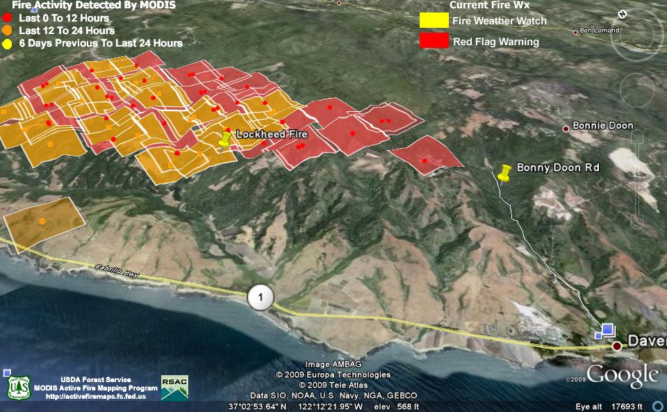
Image courtesy Google Earth and Firefighter Blog [here]. Click for larger image.
***************
Situation as of 08/13/2009 9:30 am
Personnel: 750+
Size: 2,400 acres
Percent contained: 0%
250 residences and 25 businesses are threatened in the town of Davenport. Unconfirmed 2 residences destroyed. Evacuations were ordered on Swanton and Last Chance roads north of Davenport.
The evacuation center has moved from Pacific School in Davenport to Vintage Church, 350 Mission St., in Santa Cruz and residents of Bonny Doon are being asked to evacuate because of concerns about shifting winds later today that could push the fire east.
Rapid fire spread in redwood/madrone/chamise brush. Fire perimeter @ 9:00am from Swanton on the coast to Ben Lomond Mountain, 2 miles S of Big Basin State Park to 1 mile N and W of Bonney Doon.
