Rock Creek Fire
Location: 18 mi N of Gerlach, Washoe Co. NV
Specific Location: Lat 40° 48´ 31″ Lon 119° 24´ 2″
Date of Origin: 07/24/2010
Cause: Lightning
Situation as of 07/26/2010 7:00 pm
Personnel: 175
Size: 6,000 acres
Percent Contained: 10%
Costs to Date: $750,000
Structures Threatened: 4 PRIM , 1 OUTB Structures Destroyed: NONE
Experienced a large blow out from thunderstorm winds. Received approx. .2 inches precipitation which helped with fire behavior after the blow out but containment remains elusive. Thunderstorm activity continues to hamper containment. Gusty outflow winds keep moving fire outside line already built.
Hoyt Fire
Location: 45 Miles NE of Fallon, Churchill Co., NV
Specific Location: New Pass Range, Lat 39° 49´ 16″ Long 117° 33´ 33″
Date of Origin: 08/20/2009
Cause: Under Investigation
Situation as of 08/24/2009 5:00 pm
Personnel: 3
Size: 10,685 acres
Percent contained: 100%
***************
Situation as of 08/23/2009 5:00 pm
Personnel: 194
Size: 10,670 acres
Percent contained: 85%
Costs to Date: $1,160,000
Precipitation fell over fire area.
***************
Situation as of 08/21/2009 noon
Personnel: 187
Size: 6,585 acres
Percent contained: 5%
The Hoyt Fire is burning on BLM-administered land in the northeastern portion of the Clan Alpine Mountains in Chruchill County, Nevada. This is about 70 miles northeast of the city of Fallon. The fire is burning in pinyon pine-juniper trees, sagebrush and grass.
Fatality: A single engine air tanker (SEAT) crashed on the Hoyt Fire on Thursday, August 20, at approximately 3:30 p.m. Pilot Dave Jamsa was flown by helicopter to medical facilities in Lovelock, Nevada, were he was pronounced dead. The National Transportation Safety Board and the Federal Aviation Administration in on-scene conducting an investigation.
Suwyn’s Type II Incident Management Team will take over management of the fire at 1800 on Friday, August 21.
Red Rock Fire
Location: California-Nevada border, ~20 miles N of Reno, Washoe Co. NV
Specific Location: E of U.S. Highway 395 near Hallelujah Junction, Lat 39° 47´ 15″, Lon 120° 01´ 47″
Date of Origin: 07/15/2009
Cause: Human, vehicle sparks
Situation as of 07/22/2009 7:00 pm
Personnel: 12
Size: 10,549 acres
Percent Contained: 100%
Costs to Date: $2,447,406
***************
Situation as of 07/20/2009 5:00 pm
Personnel: 205
Size: 10,549 acres
Percent Contained: 95%
Costs to Date: $2,447,406
Minimal fire. Close out today.
***************
Situation as of 07/20/2009 9:30 am
Personnel: ~325*
Size: 10,579 acres
Percent Contained: 90%
*Combined Trailer 1 and Red Rock Fire personnel: 478
***************
Situation as of 07/18/2009 5:00 pm
Personnel: 478
Size: 10,549 acres
Percent Contained: 60%
Costs to Date: $869,256
***************
Situation as of 07/17/2009 6:30 pm
Personnel: 350
Size: 9,898 acres
Percent Contained: 40%
Estimated Containment Date: Sunday July 19th
***************
Situation as of 07/16/2009 6:00 pm
Personnel: ~300
Size: 6,051 acres
Percent Contained: 30%
NE side of the fire has pushed over the Peterson Range onto the valley floor in the Rancho Haven area. W side of the fire is backing down the slope with a 1/4-1/2 mile flaming front. S side is backing down within 2 miles N of Cold Springs area. NW side is burning cross-slope to the NW.
Structure protection for both Rancho-Haven and Cold Springs is being monitored and handled through Reno Fire Department. Units are in the area and will continue to assess the situation and threat. Personnel reported at 4:40pm today (7/16) that the fire is making an aggressive run to the NE and is within 1 mile of closest structures; aircraft activity is increasing, and the fire is close to “trigger points” that would initiate an evacuation plan. Washoe County Sheriff’s Department SAR volunteers are prepared to contact local residents about the potential need to evacuate.
Mike Whalen’s Type II Incident Management Team will take over this fire at 0600 on 7/17.
Aircraft are being used to cool the fire ahead of the handcrews.
Hwy-395 is currently open with no controls. Travelers are requested to watch out for fire apparatus and vehicles in and around the fire area.
Arizona California Colorado Idaho Montana Nevada New Mexico Oregon Other States Utah Washington
by admin
leave a comment
Post-Fire Vegetation Conditions on the National Forests
The USFS RAVG interactive website [here]:
… offers an initial description of post-fire vegetative conditions using the Rapid Assessment of Vegetation Condition after Wildfire (RAVG) process. RAVG analysis looks at fires that burn more than 1,000 acres of forested National Forest System (NFS) lands, beginning with fires that occurred in 2007. These fires result in direct losses of vegetative cover and many of the benefits associated with forested ecosystems.
NFS lands experience thousands of wildfires every year, most of which are relatively small. The largest fires typically account for 90% of the total acreage burned. RAVG analysis provides a first approximation of areas that due to severity of the fire may require reforestation treatments. These reforestation treatments would re-establish forest cover and restore associated ecosystem services. This initial approximation could be followed by a site-specific diagnosis and development of a silvicultural prescription identifying reforestation needs.
Search for RAVG wildfire summaries using the Select Wildfires… “By Year…”, “By State…”, or “By National Forest/Grassland…” menus (does not allow multiple criteria selection) to produce lists of wildfires; or, you may select an individual wildfire using the “By Wildfire…” selection menu. You may also select a Forest Service Region on the map below to display a wildfire list for that region of the United States.
East Slide Rock Ridge WFU Fire
Location: 15 miles SE of Jarbidge, Elko Co. NV
Specific Location: Humboldt NF, Lat 41° 46´ 48″ Lon 115° 19´ 38″
Date of Origin: 08/10/2008
Cause: lightning
Situation as of 09/14/2008 5:00 PM
Personnel: 6
Size: 54,549 acres
Percent Contained: 50%
Desired maximum fire size: does not apply anymore
Costs to date: $8,873,000??? (no explanation for a reduction in costs of $600,000)
No active flame observed.
***************
Situation as of 09/10/2008 6:00 PM
Personnel: 39
Size: 54,549 acres
Percent Contained: 50%
Desired maximum fire size: does not apply anymore
Costs to date: $9,571,300
Interior islands of heavy fuel continue low intensity burning. Isolated creeping and some single and group tree torching.
***************
Situation as of 09/07/2008 5:30 PM
Personnel: 79
Size: 54,549 acres
Percent Contained: 50%
Desired maximum fire size: does not apply anymore
Costs to date: $9,240,530
No explanation given for reported reduction in costs.
Interior islands of heavy fuel continue low intensity burning. Isolated creeping and some single and group tree torching.
***************
Situation as of 09/06/2008 6:00 PM
Personnel: 96
Size: 54,549 acres
Percent Contained: 50%
Desired maximum fire size: does not apply anymore
Costs to date: $9,387,160
Type 3 Team will remain in place until threat of escape no longer exists. On 9/4 there was an accident with an excavator that tipped over during rehab sustaining no injuries and no damage.
Continue monitor conditions inside wilderness by helicopter, patrol and mop-up outside wilderness with crews and engines, and continue with rehab.
***************
Situation as of 09/02/2008 6:00 PM
Personnel: 271
Size: 54,549 acres
Percent Contained: 50%
Desired maximum fire size: does not apply anymore
Costs to date: $8,400,000
Containment of areas outside the wilderness occured today.
Jurisdictional interest and involvement has declined. [What does that mean?]
***************
Situation as of 09/01/2008 5:45 PM
Personnel: 449
Size: 54,329 acres
Percent Contained: 50%
Desired maximum fire size: does not apply anymore
Costs to date: $7,700,000
Mass demob of line resources began today in preparation for transition to a T3 incident on Wednesday 9/3. Radiometric mapping of heat sources continued today and showed very limited heat sources near the line outside of the wilderness. Spike camps were closed.
***************
Situation as of 08/31/2008 5:30 PM
Personnel: 678
Size: 54,329 acres (58,036 acs?)
Percent Contained: 40%
Desired maximum fire size: does not apply anymore
Costs to date: $7,200,000
Acreage figure reflects an actual growth on the perimeter of 660 acres and 4,890 acres in unburned islands in the interior that were previously excluded from reported acreages. Incident start date was changed to reflect info found on the initial 209 dated 8/10. Burned Acreage Ownership: Humboldt-Toiyabe National Forest = 54,329: Elko District Bureau of Land Management = 2,043: Private = 1,664. [Note: this may be a mistake. These numbers add up to 58,036 acres. I think they got their math wrong. - Ed].
***************
Situation as of 08/30/2008 5:30 PM
Personnel: 721
Size: 48,779 acres
Percent Contained: 30%
Desired maximum fire size: does not apply anymore
Costs to date: $6,600,000
All portions of the North line were held successfully during today’s wind event and Red Flag conditions. High wind conditions prevented use of helicopters in the afternoon. Radiometric mapping of heat sources was begun today and showed minimal areas of intense heat and a few points of moderate or subsiding heat scattered along the North line.
Active fire behavior in timbered areas in the interior of the fire mainly in the Jarbidge Wilderness. Terrain and wind driven uphill crown runs were observed in Cottonwood Creek along the southern edge of the fire. A significant smoke column was again generated today from the upper portions of Cottonwood Creek.
***************
Situation as of 08/29/2008 5:30 PM
Personnel: 714
Size: 48,157 acres
Percent Contained: 25%
Desired maximum fire size: does not apply anymore
Costs to date: $5,800,000
Governor Gibbons, US Congressman Heller, Nevada State Forester Pete Anderson, and other government and local officials visited helibase, received a briefing, and toured the fire area.
A significant amount of line was declared contained along the northern flank of the fire. In anticipation of the wind event tomorrow, aggressive action to secure the North flank continued. Air resources, including 7 helicopters, are being used to provide water to secure line and mop up hot spots. Contingency plans finalized for protection of ICP/Cottonwood Ranch and areas affected by potential fire spread to the NE.
Continue direct suppression in areas outside the wilderness. Preparing line along eastern flank of the fire for a planned burnout on 8/31 that will secure line outside of wilderness.
***************
Situation as of 08/28/2008 7:20 PM
Personnel: 713
Size: 47,701 acres
Percent Contained: 10%
Desired maximum fire size: does not apply anymore
Costs to date: not reported, est. $5,000,000
Structures Threatened: 100 residences, 80 outbuildings, reflect the estimated number in the community of Murphy Hot Springs, ID.
All non-fireline qualified support people were removed from the Pole Creek spike camp due to the proximity of the fire. Three historic cabins were verified as lost during yesterday afternoons active burning in the wilderness.
A community meeting was held in Jarbidge to discuss allocation of fire resources over the next few days. The Director of Nevada Division of Forestry visited Thursday as the advance party for Friday’s visit from the Governor of Nevada and a US Congressman.
Aggressive action continued with a burnout in Div A to secure the N flank in advance of Saturday’s red flag conditions.
***************
Situation as of 08/27/2008 8:00 PM
Personnel: 653
Size: 43,275 acres
Percent Contained: 10%
Desired maximum fire size: does not apply anymore
Costs to date: not reported, est. $3.4 million
Structures Threatened: 100 residences, 80 outbuildings, reflect the estimated number in the community of Murphy Hot Springs, ID.
The road closure on Forest Road 74 was extended to the N to the Three Creeks area in Owyhee County in Southern Idaho. There is a strong probablity that 3 historic cabins in the Jarbidge Wilderness were lost today but fire behavior prevented verification attempts until tomorrow.
Burned Acreage Ownership: Humboldt-Toiyabe National Forest = 40,971: Elko District Bureau of Land Management = 698: Private = 1606
Active wind driven flanking and head fire in the sage brush. Additional spread to the Southwest towards Matterhorn Peak in the Jarbidge Mountains at high elevations was also observed.
***************
Situation as of 08/26/2008 5:00 PM
Personnel: 559
Size: 38,595 acres
Percent Contained: 0%
Desired maximum fire size: does not apply anymore
Costs to date: $2,400,000
Structures Threatened: 100 residences, 80 outbuildings, reflect the estimated number in the community of Murphy Hot Springs, ID.
Acreage increase on todays report occurred 8/25. Acres reported yesterday (28,000) was an estimate. Acres reported on this report are from IR flight evening of 8/25.
Fire activity moderated today allowing line personnel to evaluate, re-engage, and continue suppression actions. Pole Creek Guard Station survived the fire front with no damage and has been reoccupied as a Spike Camp. An Evacuation Guide was finalized for Jarbidge, Murphy Hot Springs, and outlying ranches in Nevada and Idaho. WFSA is being revised. Focus will be perimeter control outside wilderness and point/zone protection along wilderness boundary.
***************
Situation as of 08/25/2008 5:00 PM
Personnel: 476
Size: 28,000 acres
Percent Contained: 0%
Desired maximum fire size: does not apply anymore
Costs to date: $1,500,000
Structures Threatened: 100 residences, 80 outbuildings, reflect the estimated number in the community of Murphy Hot Springs, ID.
Sheriff’s department notified numerous ranches in northern NV and southern ID as well as residents of Murphy Hot Springs of potential evacuation. Pole Creek Guard Station was foamed and evacuated. Fire made significant runs to N and NE and is most certainly off Forest Service lands to north. Fire has exceeded WFSA boundaries along the North and NE flanks.
A burnout operation was conducted last evening along Road 074 on the NE flank of fire. Burnout was conducted to try to prevent forecasted winds pushing fire beyond this line. The burnout held for about 2 hours in Red Flag conditions before being overwhelmed by fire. Crews disengaged from fire around 1400 due to extreme fire behavior.
The acreage for the fire is estimated at 28,000 acres and the estimate is most likely conservative. Fire doubled in size today. Extreme fire behavior with spotting in excess of 1/2 mile. Fire was wind driven with sustained crown runs in timber with rapid rates of spread in sagebrush and grass fuels.
Transfer of command occurred at 2100 last night from Svalberg Fire Use Team to Rocky Mountain Type 1 Team (Summerfelt).
***************
Situation as of 08/24/2008 6:00 PM
Personnel: 340
Size: 14,489 acres
Percent Contained: 0%
Desired maximum fire size: does not apply anymore
Costs to date: $1,135,440
30 historic cabins currently threatened by the fire as well as the Forest Service administrative site.
Pulled fire personnel from the line in all divisions due to very active fire behavior in late afternoon. Due to lack of effectiveness, all aerial resources were also pulled.
A SAFECOM was filed today for a hydraulic pressure problem with the landing gear of a fixed wing aircraft. The pilot declared an emergency and crash-rescue was positioned at the airport. Emergency landing gear procedures were executed and the aircraft landed safely.
Very active fire behavior during the afternoon hours with group tree torching, spotting and crown runs. Primary fire spread was to the NW in the North Fork of Falls Creek, to the NW along Biroth Ridge, to the NE in upper Canyon Creek and to the SSE in the Middle Fork of Cottonwood Creek.
***************
Situation as of 08/22/2008 8:00 PM
Personnel: 145
Size: 11,252 acres
Percent Contained: 0%
Desired maximum fire size: 113,000
Costs to date: $508,144
Incident converted from wildland fire use incident to wildfire in response to updated complexity analysis and uncontained fire outside MMA boundary; WFSA developed and awaiting approvals. Type 1 IMT (Summerfelt) ordered and scheduled to inbrief at 1600 tomorrow (Saturday). Expanded forest area closure in effect at noon today; road guard group deployed for public contact.
***************
Situation as of 08/21/2008 7:00 PM
Personnel: 100
Size: 9,901 acres
Percent Contained: 0%
Desired maximum fire size: 113,000
Costs to date: $196,733
~300 acres outside MMA/wilderness boundary; air resources made progress in containing spread. Area closure expanded to reflect increased fire size and projected movement. Pole Creek Guard Station threatened.
***************
Situation as of 08/21/2008 1:00 PM
Fire has blown up to over 8,500 acres and surged out of the wilderness area. Aerial retardant drops have been requested. Four 20-person crews, along with engines and dozers, are scheduled to arrive Friday and Saturday.
The Humboldt-Toiyabe NF issued the following statement:
The East Slide Rock Ridge Fire, burning in the remote Jarbidge Wilderness, is proving itself useful in getting bug-infested, dead-and-dying trees off the landscape. It’s estimated that half the trees in the fire area are either dead, diseased or have reached the end of their natural lifespan. Fire is playing its role in nature’s cycle.
The problem with that is half the trees were not dead, at least not until the fire killed them. Also, what in the world is “nature’s cycle” and when did that become a silvicultural goal? This is the kind of pseudo-scientific, rah rah for holocaust propaganda that makes the USFS look like arsonists without a clue.
***************
Situation as of 08/20/2008 5:00 PM
Personnel: 33
Size: 5,000 acres
Percent Contained: 0%
Desired maximum fire size: 113,000
Costs to date: $134,120
Structures Threatened: 30 historic cabins
Group torching with crown runs in the sub-alpine fir and medium range spotting. Fire behavior continues to increase daily with afternoon winds.
5 person AMR module, aerial resources, and incoming resource to limit fire movement to the east and northeast; attempting to keep the fire in the Jarbidge Wilderness. FUMT will be borrowing local resources for contingencies. Begin setting up spike camp at Pole Creek.
***************
Situation as of 08/17/2008 6:00 PM
Personnel: 20
Size: 300 acres
Percent Contained: 0%
Desired maximum fire size: not reported
Costs to date: not reported
Significant movement due to winds and low humidity added about 100 acres. Short crown runs, torching and spotting up to 1/4 mile. All ground personnel were relocated to monitor at a greater distance.
Rock Creek Fire
Location: 20 miles N of Battle Mountain, Lander, Elko Cos., NV
Specific Location: Lat 40° 59´ 38″ Lon 116° 39´ 20″
Date of Origin: 08/10/2008
Cause: under investigation
Situation as of 08/10/08 6:00 PM
Total Personnel: 25
Size: 2,300 acres
Containment: 20%
Initial attack at 1500. Significant progress made on majority of line. Problem area will be southern perimeter of fire on Black Mtn. Wind gusts and fine fuel loading caused fire to spread rapidly. Continue to utilize BAM tanker base to reload SEATS if needed.
Arizona California Colorado Idaho Montana Nevada New Mexico Oregon Other States Utah Washington
by admin
leave a comment
About W.I.S.E. Fire Tracking
Last Spring W.I.S.E. initiated this Fire Tracking site. We have been endeavoring to track the larger fires in the West. So far we have tracked over 170 fires, many still active.
The way W.I.S.E. Fire Tracking works is that each fire (that we choose to track) gets it’s own post. That post is updated periodically. We try to update on a daily basis while the fire is active, but some days the information is not available.
If a fire you are interested in is not on the main page (it only holds 15 posts), then there are a few ways you can find it. First, try typing the name of the fire in the search applet in the upper righthand sidebar. Second, you can click on the “state” category if you know what state the fire is in. Third, if you know what month the fire started, you can look in the archives under that month.
For each fire we are attempting to post daily stats for acreage, personnel, percent containment, and suppression costs to date. That way each post becomes a historical record for that fire. You can see how the fire grew day by day, along with the changes in the other stats.
W.I.S.E. Fire Tracking is in blog form, designed for feedback. People on the scene, or anywhere else for that matter, can contribute information, photos, or ask questions.
W.I.S.E. Fire Tracking is free. It costs the taxpayers nothing. Your donations are sincerely appreciated. See the Join WISE page [here].
Unlike other fire sites, W.I.S.E. Fire Tracking is not designed by and for firefighters. Our expertise and concern is about forests and other landscape types, and so we can provide indepth analysis regarding the effects of a particular fire on multiple forest values and resources. By collecting and posting the daily record for each fire, we are establishing the basic information needed to analyze fire effects.
Please take some time to explore W.I.S.E. Fire Tracking. There is a wealth of information being collected there. Sometimes you may need to read between the lines because the whole truth is only hinted at. Your analysis of specific fires is also welcome, as are your photos, maps, and on-the-ground observations.
Gooseberry Fire
Location: 10 mi SE of Doyle, CA, 20 mi W of Pyramid Lake, Washoe Co. NV
Specific Location: near Gooseberry Spring, Lat 39° 56´ 6″ Lon 119° 57´ 11″
Date of Origin: 07/29/2008
Cause: lightning
Situation as of 07/31/08 5:30 PM
Personnel: 194
Size: 3,042 acres
Percent Contained: 100%
Fire contained today. Handline construction completed. Mopup operations continue 100-300 feet inside the perimeter.
***************
Situation as of 07/29/08 9:00 PM
Personnel: 173
Size: 800 acres
Percent Contained: 0%
Critical Mule Deer winter range is being consumed. The threat to significant Sage Grouse and Big Horn Sheep habitats.
Inaccessibility caused delays of resources getting into position for anchoring the fire and initiating initial attack. Gusty and erratic winds causing significant fire behavior. Significant fire runs in continuous pinon-juniper. Crowning and spotting. Rapid rates of spread.
Arizona California Colorado Idaho Montana Nevada New Mexico Oregon Other States Utah Washington
by admin
leave a comment
About W.I.S.E. Fire Tracking
This Spring W.I.S.E. initiated THIS Fire Tracking site. We have been endeavoring to track the larger fires in the West. So far we have tracked over 110 fires, many still active.
The way W.I.S.E. Fire Tracking works is that each fire (that we choose to track) gets it’s own post. That post is updated periodically. We try to update on a daily basis while the fire is active, but some days the information is not available.
If a fire you are interested in is not on the main page (it only holds 15 posts), then there are a few ways you can find it. First, try typing the name of the fire in the search applet in the upper righthand sidebar. Second, you can click on the “state” category if you know what state the fire is in. Third, if you know what month the fire started, you can look in the archives under that month.
For each fire we are attempting to post daily stats for acreage, personnel, percent containment, and suppression costs to date. That way each post becomes a historical record for that fire. You can see how the fire grew day by day, along with the changes in the other stats. That’s something InciWeb doesn’t do.
W.I.S.E. Fire Tracking is in blog form, designed for feedback. People on the scene, or anywhere else for that matter, can contribute information, photos, or ask questions. It’s a two-way communication, something else InciWeb does not do.
W.I.S.E. Fire Tracking is free. It costs the taxpayers nothing. That’s definitely not the case with InciWeb. Your donations are sincerely appreciated, in any case.
Unlike other fire sites, W.I.S.E. Fire Tracking is not designed by and for firefighters. Our expertise and concern is about forests and other landscape types, and so we can provide indepth analysis regarding the effects of a particular fire on multiple forest values and resources. By collecting and posting the daily record for each fire, we are establishing the basic information needed to analyze fire effects.
InciWeb, the government fire reporting site, has been up and down this year. Right now it is functional again. If the InciWebbers show they can report fires consistently and without server glitches, we may pick and choose which fires we track more selectively. Our intention was never to compete with InciWeb or supplant them. We only provided a comprehensive fire reporting service because we thought such was needed during their long absence.
Due to the workload involved with W.I.S.E. Fire Tracking, the other subsites at W.I.S.E. have been neglected. Sorry about that. Hopefully in a week or two the fire season will calm down a bit and the other subsites will get more attention.
In that regard, if you feel like reviewing a new book or paper of exceptional quality and cutting-edge, new paradigm thinking in the environmental sciences, please do so. We are always happy to post contributions from the experts.
For those select few among you to whom we have promised specific projects, please bear with us. We have not forgotten. The list is still right here on the W.I.S.E. bulletin board. Your project is circled in red. We will get to it when we can and eventually for sure.
Please take some time to explore W.I.S.E. Fire Tracking. There is a wealth of information being collected there. Sometimes you may need to read between the lines because the whole truth is only hinted at. Your analysis of specific fires is also welcome, as are your photos, maps, and on-the-ground observations.
Arizona California Colorado Idaho Montana Nevada New Mexico Oregon Other States Utah Washington
by admin
leave a comment
Please Donate to the Cause
W.I.S.E. is non-profit. Heck, we’re damn near non-income. But we are endeavoring against all odds to save forests and spread good information and knowledge about stewardship of our forests and landscapes.
We’re trying to save forests. We’re trying to stop or reduce the megafires that are ravaging our forests. We’re trying to make this planet a more habitable place for all life forms.
To that end we have created and are managing 12 websites. Our most recent site, W.I.S.E. Fire Tracking, is building records of the major fires burning this year, so that we can evaluate those fires after the season is over and seek ways to lessen the destruction.
We have not shirked from controversy. We have pushed the envelope. We have berated the Powers That Be for their incompetence and misguided policies that destroy forests, both public and private, and incinerate homes, farms, and ranches, and pollute the air and water, and cripple economies, and drain the Treasury.
We have endeavored to post the best, most cutting edge science, so that visitors can learn the facts for a change instead being pepper sprayed with rude and a-scientific propaganda all the time. We are a beacon, a light in the smoky darkness of a thousand forest fires burning at once.
W.I.S.E. is free. Our sites are open to all, free of charge, without a fee, buy in, ticket charge, or gate receipt.
But it is not free to do all this work. It is time consuming. Moreover, the expertise displayed here is the result of hundreds of years of combined professional effort. All of the experts published at W.I.S.E. have contributed their knowledge for free, and we are deeply grateful, but we also recognize that their expertise is hard won and represents lifetimes of dedication.
Your financial contributions are also deeply appreciated. We share this wonderful letter we received today, with gratitude:
Dear Mike,
Enclosed please find a check in the amount of $200. I hope it will help to keep your great sites going and allow you to continue to share wisdom and expertise.
As I promised myself, “a dollar a day” contribution will hopefully assist this endeavor to spread the word about forest health in particular and the rational study of the environment in general.
Randy
We send Randy a big Thank You. He would never admit it, but he is a victim of excruciatingly bad forest policies. His home and landscape are under tremendous threat. His area has been visited by fire storms emanating from mis-managed federal forests and hundreds of his neighbors’ homes have been incinerated by those fire storms. There is little he can do to change those terrible policies on his own.
But W.I.S.E. is attempting to do just that. We want to save rural homes from predicted, preventable fires. We desire to save the taxpayers $billions in emergency fire costs by encouraging the application of restoration forestry to millions of acres, thereby rendering forest safe and resilient to fire and far less prone to catastrophic destruction by holocaust. We wish to protect, maintain, and perpetuate forests, wildlife habitat, watersheds, airsheds, recreation opportunities, and all the other amenities and values that forests provide us. We are deeply cognizant of the heritage of our landscapes, and promote the respect and restoration that our heritage deserves.
That is our quest. Little by little we are having an effect. Top policy makers are reading our sites. The pendulum is being swung, the elephant is slowly moving.
Your contributions make it possible for W.I.S.E. to pursue this quest. Our budget is threadbare. We can barely pay our monthly Internet fees. But with your help we will persevere.
Your contributions are tax deductible. The Western Institute for Study of the Environment is a 501(c)(3) non-profit collaboration of environmental scientists, practitioners, and the interested public.
W.I.S.E. provides a free, on-line set of post-graduate courses in environmental studies, currently fifty Topics in eight Colloquia, each containing book and article reviews, original papers, and essays. In addition, we present two Commentary sub-sites, a news clipping sub-site, and the W.I.S.E. Fire Tracking site.
Our mission is to further advancements in knowledge and environmental stewardship across a spectrum of related environmental disciplines and professions. We teach and advocate good stewardship and caring for the land.
Please help us out. Please visit our donations page [here].
Thank you.
Arizona California Colorado Idaho Montana Nevada New Mexico Oregon Utah
by admin
leave a comment
Lightning Storms of June 30
Vaisala Lightning Explorer [here] has been registering significant lightning strikes this afternoon in Eastern Oregon, Northern Nevada, Central and Southern Idaho, Utah, Southern Montana, Western Wyoming, Western Colorado, Northern Arizona, and Northwestern New Mexico.
CA Fire Map Sunday 06/29 AM
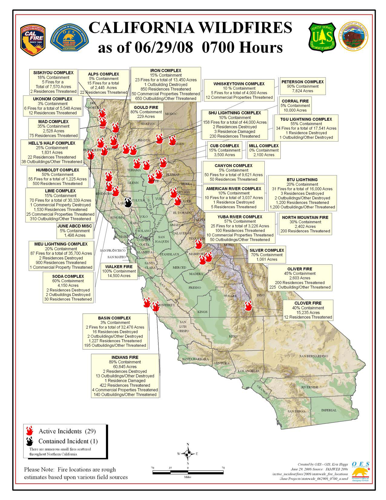
Click map for larger image (1.1 MB).
RED FLAG WARNING in effect from 1 pm this afternoon to 5 am PDT Monday for Northeast California including E Shasta Co., Burney Basin, W. slope Sierra Nevada including Plumas NF; Southern and Central Oregon; and Northern and Central Nevada for scattered dry thunderstorms. Many storms today will produce little to no rainfall due to dry air above the surface. By Sunday more storms will become wetter but shorter rainfall duration is expected due to increased storm motion.
California Summary 06/29/08
Total Fires: 1,420
Total Acres Burned: 356,134 (556 sq mi)
Resources Committed
Personnel Committed: 18,608
Fire Engines: 1,377
Hand Crews: 465
Dozers: 331
Water Tenders: 375
Helicopters: 92
(These numbers are totals from state, local and federal firefighting agencies. Updated 6/28 at 9:00 p.m.)
Highway closures: State highways and local roads are closed throughout California due to wildfire activities. Closures and delays are in place for State Highways 1 (Big Sur Area), 32, 36, 70, 96, and 151. Numerous county and local roads are closed as well. Travelers are advised to seek current information from local law enforcement.
Evacuations: Areas of Butte, Monterey, and Shasta counties are under evacuation orders at this time. Precautionary evacuation orders are in place for areas in Butte, Lassen, Mariposa, Mendocino, Shasta and Tehama counties. Residents are advised to monitor the fire situation in their areas, check with local law enforcement agencies for information, and be prepared to evacuate when necessary.
Structures Threatened: 7,589 residences, 135 commercial, 2,856 outbuildings. Structures Destroyed: 29 residences, 1 commercial, 21 outbuildings.
Wed AM Update
We have updated all listed fires from information we gleaned last night. That info was sparse, as might be expected during this major fire bust (of historic proportions).
To access all active fires, click on “Archives_June 2008″ in the righthand sidebar. Scroll to the bottom and click “keep looking”. There are 15 postings per page, and 3 pages of active fires at present.
Elkhorn 2 Fire
Location: 40 Miles NE Tonopah, Nye Co. NV
Specific Location: Lat 38° 35´ 16″; Lon 116° 40´ 39″
Date of Origin: 06/14/2008
Cause: Unknown
Situation as of 06/23/08 4:30 PM
Total Personnel: 143
Size: 6,198 acres
Percent Contained: 90%
Costs to Date: $1,000,000
Increase in acreage due to more accurate mapping. Crews and helicopter water support vital to holding the west ridge and northwest side.
***************
Situation as of 06/20/08 3:00 PM
Total Personnel: 247
Size: 4,700 acres
Percent Contained: 50%
Costs to Date: $500,000
Significant progress made with back firing and helitorch burnout operations. Estimated containment 06/23/2008.
***************
Situation as of 06/19/08 3:00 PM
Total Personnel: 225
Size: 2,350 acres
Percent Contained: 30%
Costs to Date: $450,000
***************
Situation as of 06/18/08 noon
Total Personnel: 148
Size: 2,006 acres
Percent Contained: 30%
***************
Situation as of 06/17/08 noon
Total Personnel: 148
Size: 1,858 acres
Percent Contained: 50%
***************
Situation as of 06/17/08 AM
Total Personnel: 96
Size: 1,858 acres
Percent Contained: 30%
Significant Events: AA 5SA struck a building while landing at the Tonopah Airport. No injuries, 5SA moved to Twin Falls for repairs. AA 15 replaced 5SA. All tankers were released at 1430 hours.
Est. containment date: 06/18/2008
Como Fire
Location: 17 miles east of Carson City, Lyon Co., NV
Specific location: near the junction of Como Mine Road and Dayton Valley Road in the Pinenut Mountains
Date of Origin: 05/08/2008 at 1455 hrs.
Cause: an excavator that knocked out a power pole.
Current Situation
Total Personnel: 225
Size: 367 acres
Containment: 20 %
Fuels Involved: Pinion and juniper, sagebrush
Summary: The Como fire is reported to have “lain down” overnight. A multi-agency communications site (Rawe Peak communications site) and sage grouse habitat remain threatened.
