Cabin Creek Fire
Location: Payette NF, 30 mi ENE of Yellow Pine, Valley Co. ID
Specific Location: Cabin Creek, trib to Big Creek, trib to M. F. Salmon River, Lat 45° 8´ 37″ Lon 114° 55´ 41″
Date of Origin: 07/30/2008
Cause: human
Situation as of 08/14/08 11:30 AM
The Cabin Creek Fire has been declared a part of the Westy WFU Fire [here]
***************
Situation as of 08/06/08 4:30 PM
Personnel: 12
Size: 5,494 acres
Percent Contained: 0%
Costs to Date: not reported
Est date of containment: 09/30/2008
Est final fire size: not reported
No attempt is being made to contain or “steer” the fire. Classic non-suppression “suppression” fire, aka Let It Burn.
***************
Situation as of 08/04/08 5:00 PM
Personnel: 12
Size: 4,200 acres
Percent Contained: 0%
Costs to Date: $262,790
***************
Situation as of 08/03/08 4:30 PM
Personnel: 7
Size: 4,000 acres
Percent Contained: 0%
Est date of containment: 09/30/08 (this means the Payette NF has no intention of containing or fighting this fire).
Fire is moving WNW and has crossed Cave Creek. This fire is not a declared WFU. It was not ignited by lightning. Yet the Payette NF is not fighting it. It will be recorded as a “suppression” fire but is actually Let It Burn.
***************
Situation as of 08/02/08 4:30 PM
Personnel: 16
Size: 3,315 acres
Percent Contained: 0%
Another major screw up by the Payette NF and fire manager Sam Hescock. At no time was there any intention of fighting this fire. Although they have lied to the public and classed the Cabin Creel Fire as a “suppression” fire, it has been Let It Burn all along.
***************
Situation as of 07/31/08 5:45 PM
Personnel: 16
Size: 900 acres
Percent Contained: 0%
Cabin creek airstrip open, structure protection in place at Taylor Ranch. Red Flag Warning for strong winds today, 10 to 15 MPH increasing to 25 TO 30 MPH in the afternoon.
***************
Situation as of 07/30/08 5:00 PM
Personnel: 7
Size: 686 acres
Percent Contained: 0%
Overhead Team Name: Hescock Type 4 IC Local
Cabin Creek airstrip closed, structure protection implemented. Initial attack resources (7 personnel) failed to contain fire. Rapid rates of spread, 95% active perimeter, high intensity fire.
Gooseberry Fire
Location: 10 mi SE of Doyle, CA, 20 mi W of Pyramid Lake, Washoe Co. NV
Specific Location: near Gooseberry Spring, Lat 39° 56´ 6″ Lon 119° 57´ 11″
Date of Origin: 07/29/2008
Cause: lightning
Situation as of 07/31/08 5:30 PM
Personnel: 194
Size: 3,042 acres
Percent Contained: 100%
Fire contained today. Handline construction completed. Mopup operations continue 100-300 feet inside the perimeter.
***************
Situation as of 07/29/08 9:00 PM
Personnel: 173
Size: 800 acres
Percent Contained: 0%
Critical Mule Deer winter range is being consumed. The threat to significant Sage Grouse and Big Horn Sheep habitats.
Inaccessibility caused delays of resources getting into position for anchoring the fire and initiating initial attack. Gusty and erratic winds causing significant fire behavior. Significant fire runs in continuous pinon-juniper. Crowning and spotting. Rapid rates of spread.
Rich Bar Fire
Location: 2 miles E of Rich Bar, Plumas Co., CA
Specific Location: S of Hwy 70, Serpentine Canyon, E Fork Feather River, Lat 40° 01´ 18″ Lon 121° 09´ 56″
Date of Origin: 07/29/2008
Cause: under investigation
Situation as of 08/17/08 6:00 AM
Personnel: 198
Size: 6,112
Percent Contained: 100%
Costs to Date: $13,233,637
Transfer of command to Type 3 IC and return of incident management to the Forest at 0600 today. Minnesota IMT closeout at 1200 hrs.
Fuels within interior islands continue to be consumed.
***************
Situation as of 08/14/08 6:00 PM
Personnel: 239
Size: 6,112
Percent Contained: 100%
Costs to Date: $12,403,104
Little or no fire spread. Fuels within interior islands continue to be consumed.
Continue with suppression rehab and patrol. 75% of the fire is in patrol status only.
***************
Situation as of 08/12/08 6:00 PM
Personnel: 435
Size: 6,112
Percent Contained: 100%
Costs to Date: $11,948,366
Crews continue with mop-up with Divs B & C in patrol status. Rush Creek and Virgilia Roads are open only to residents. Caribou Road and adjacent campgrounds on the North Fork open to public use.
***************
Situation as of 08/11/08 6:00 PM
Personnel: 472
Size: 6,112
Percent Contained: 100%
Costs to Date: $11,529,946
The Forest closure was reduced today to encompass a smaller area around the fire. The Caribou Road and the adjacent campgrounds on the North Fork of the Feather River are now open to public use.
***************
Situation as of 08/10/08 6:00 PM
Personnel: 515
Size: 6,112 (Rich Fire 6,112 acs, Belden Fire 474 acs again reported with Canyon Complex)
Percent Contained: 100%
Costs to Date: $11,127,960
***************
Situation as of 08/09/08 6:00 PM
Personnel: 572
Size: 6,112 (Rich Fire 6,112 acs, Belden Fire 474 acs again reported with Canyon Complex)
Percent Contained: 100%
Costs to Date: $10,613,444
100% containment today. Transfer of command to Mannelin’s Minnesota IMT will take place at 0600 hours on 8/10. Continue mop-up on entire fire and begin suppression rehab.
***************
Situation as of 08/08/08 5:00 PM
Personnel: 707
Size: 6,586 (Rich Fire 6,112 acs, Belden Fire 474 acs)
Percent Contained: 95%
Costs to Date: $9,986,000
Crews continue with heavy mop-up on all divisions. The Rush Creek and Virgilia Roads are open only to residents. Forest closures include Bucks Lake Wilderness and the Middle Fork of the Feather River Canyon. Continued transition with Type 2 IMT (Mannelin)
***************
Situation as of 08/07/08 5:00 PM
Personnel: 912
Size: 6,586 (Rich Fire 6,112 acs, Belden Fire 474 acs)
Percent Contained: 90%
Costs to Date: $9,403,000
Structures Destroyed: 2 residences, 7 outbuildings
The Rush Creek and Virgilia Roads are open only to residents. Forest closures include Bucks Lake Wilderness and the Middle Fork of the Feather River Canyon.
PNW Team 2 began transition with Type 2 IMT (Mannelin). Little or no fire spread was observed. Fuels within interior islands continue to be consumed.
***************
Situation as of 08/05/08 5:00 PM
Personnel: 1,137
Size: 6,570 (Rich Fire 6,042 acs, Belden Fire 474 acs)
Percent Contained: 57%
Costs to Date: $6,981,526
Structures Destroyed: 2 residences, 7 outbuildings
All evacuations were lifted at 1000. This includes Rich Bar, Rich Gulch, Rush Creek, and Virgilia. The Rush Creek and Virgilia Roads are open only to residents. Highway 70 continues to use a pilot car operation. Forest closures include Bucks Lake Wilderness and the Middle Fork of the Feather River Canyon.
Crews continue with heavy mop-up on the southern and western perimeters. Burnout operations were completed on the eastern perimeter.
***************
Situation as of 08/04/08 5:30 PM
Personnel: 1,170
Size: 6,571 (Rich Fire 6,043 acs, Belden Fire 474 acs)
Percent Contained: 53%
Est containment date: 8/10/08
***************
Situation as of 08/03/08 5:30 PM
Personnel: 1,065
Size: 6,371 (Rich Fire 5,897 acs, Belden Fire 474 acs)
Percent Contained: 45%
Costs to Date: $4,189,164 (Rich Fire: $4,114,000. Belden Fire $75,164 costs. Belden Fire costs reflect only suppression activities (air operations only) since 7/30. Previous Belden Fire costs are included in Canyon Complex costs.)
Structures Destroyed: 2 residences
Highway 70 continues to use a pilot car operation. Evacuated residents are being escorted into their property for a short term assessment of damage. No evacuees are being allowed back into their residences on a permanent basis.
Completion of burnout operations in the Fales Basin area. Crews continue to construct direct and indirect handline on the eastern perimeters. Moderate slopover occurred from burnout operations on the northwestern portion of the fire near the 26N22 road. Helicopter bucket drops were heavily used in conjunction with hand crews and engines.
***************
Situation as of 08/02/08 5:00 PM
Personnel: 890
Size: 5,673 (Rush Fire 5,199 acs, Belden Fire 474 acs)
Percent Contained: 15%
Costs to Date: $2,209,500
Highway 70 continues to use a pilot car operation. The USFS structure protection/evacuation plan was revised by CalFire, County O.E.S. and local Sheriff’s office.
Burnout operations conducted in the Virgilia area. Crews continue to construct direct and indirect handline on the northwest and eastern perimeters.
***************
Situation as of 08/01/08 4:30 PM
Personnel: 646
Size: 5,198 acres (Rush Fire 4,724 acs, Belden Fire 474 acs)
Percent Contained: 10%
Costs to Date: $1,595,500
Re-opened Highway 70 utilizing pilot cars.
Belden Fire, formerly with the Canyon Complex, is now included in this fire (since they are only 2 mi apart). Rich Fire: 4,724 acres, 10% contained, $1,590,000 costs. Belden Fire: 474 acres, 70% contained, $5,500 costs reflecting suppression activities (air operations only) since PNW Team 2 took command on 7/31 at 1800. Previous Belden Fire costs are included in Canyon Complex costs.
Moderate to high fire behavior with group torching and low-duration crowning. In Branch I, south of East Branch North Fork Feather River, continue burning the east flank of the fire to the river. In Branch II on the western flank, hold and secure line from Deadwood Gulch to Road 26N22 and continue preparation Road 26N22 to the north. In Branch III on the western flank, continue line construction from Road 26N67 to Rush Creek. Hold and secure line from the Rich Gulch area to Rush Creek. Improve roads and construct dozer line from Road 26N67 northerly.
***************
Situation as of 07/31/08 6:00 PM
Personnel: 284
Size: 4,200 acres
Percent Contained: 5%
Costs to Date: not updated
High fire behavior; group torching and short duration crowning. Continuing structure protection assessment for communities at risk along CA Highway 70 and plan for potential additional evacuations.
***************
Situation as of 07/30/08 6:00 PM
Personnel: 170
Size: 3,000 acres
Percent Contained: 0%
Costs to Date: $200,000
Evacuations in-place for the communities of Rich Bar, Rush Creek and Virgilia. Hard road closure in-place on CA Highway 70.
Transition from Arizona CWZ Type 2 Team (Sciacca, IC) to PNW 2 Type 1 Team (Hoff, IC). Continue structure protection assessment for communites at risk along CA Highway 70 and plan for potential additional evacuations.
***************
Situation as of 07/29/08 6:00 PM
Personnel: not reported
Size: 50 acres
Percent Contained: 0%
Initial attack by crews from the Canyon Complex [here]. Fire is 4 mi E of Belden Fire in Canyon Complex. High fire behavior with group torching, spotting, and extended uphill runs.
New Fork Lakes Fire
Location: 15 miles N of Pinedale, Sublette Co., WY
Specific Location: near New Forks Lake, Bridger-Teton NF, Lat 43° 6´ 20″ Lon 109° 54´ 37″
Date of Origin: 07/29/2008
Cause: human
Situation as of 08/31/08 1:30 PM
Personnel: 6
Size: 15,089 acres
Percent Contained: 60%
Costs to Date: $2,830,000
FLE [fire line explosives] operations complete yesterday. Fire received some precip, but not significant so far. Expect more precip tonight and tomorrow. No staffing today or tomorrow because of weather conditions.
***************
Situation as of 08/29/08 5:45 PM
Personnel: 6
Size: 13,986 acres
Percent Contained: 60%
Costs to Date: not updated, est $2.9 million
***************
Situation as of 08/28/08 5:20 PM
Personnel: 6
Size: 13,936 acres
Percent Contained: 60%
Costs to Date: $2,830,000
Implemented trail closures out of Spring Creek Park Trailhead. Completed structure wrap on Spring Creek Park rider’s cabin.
Group tree torching with short to moderate range spotting. Small uphill crown runs. Backing and flanking fire following heavy fuels.
Planning to construct contingency lines in light fuels with Fireline Explosives.
***************
Situation as of 08/27/08 5:20 PM
Personnel: not reported
Size: 13,200 acres
Percent Contained: 60%
Costs to Date: $2,800,000
Initiated slowing action on Management Action Point 1 with Type 3 helicopter and ground personnel. Inserted pumps and hose into Chamber’s Bay Structures near Fremont Lake. Continued monitoring on SE edge of fire.
***************
Situation as of 08/26/08 3:00 PM
Personnel: 2
Size: 12,373 acres
Percent Contained: 65%
Costs to Date: $2,800,000
New Fork Fire is still being monitored by the local District. No trail or area closures currently in place. 2 FEMOs will be on the fire starting tomorrow to monitor activity.
***************
Situation as of 08/11/08 5:45 PM
Personnel: 56
Size: 11,960 acres (not updated)
Percent Contained: 65%
Costs to Date: $2,359,624 (not updated)
The percent contained has changed from 95 to 65. The entire north end of the fire is burning within wilderness and management has changed the percentage to reflect this correction. Fire is in monitor status.
***************
Situation as of 08/09/08 2:00 PM
Personnel: 64
Size: 11,960 acres
Percent Contained: 95%
Costs to Date: $2,359,624
Fire currently being managed by local unit. Continue line improvement where needed and monitor fire activity.
***************
Situation as of 08/07/08 6:00 PM
Personnel: 422
Size: 11,960 acres reported
Percent Contained: 55%
Costs to Date: $1,688,854
Definitive fire perimeter established today resulting in reduction of acreage burned. [<em>This is the second remapping in two days. Who knows if the newly reported numbers are accurate? - Ed</em>].
***************
Situation as of 08/06/08 6:00 PM
Personnel: 401
Size: 13,209 acres
Percent Contained: 55%
Costs to Date: $1,688,854
Reduction in acreage due to more accurate mapping.
Forest Wilderness closures in effect today. Progress on assigned portions of the line for AMR 55% per Delegation of Authority. [<em>That means the Appropriate Management Response has been determined to be fighting the fire on the east side only, allowing the west side to burn freely -Ed</em>].
Team will secure SW side of fire in Willow Lake/Fremont Lake area and on E side of New Fork Lake, to prevent fire from exiting the Bridger Wilderness. The W side will be unstaffed. [<em>This is a risky strategy. There are still 4 to 7 weeks until Fall rains. Allowing the fire burn actively may result in a blow up when the regular Aug winds hit. We will continue to track this fire to evaluate the outcome of the AMR strategy - Ed</em>].
***************
Situation as of 08/05/08 6:00 PM
Personnel: 323
Size: 13,791 acres
Percent Contained: 33%
Costs to Date: $1,306,881
Successful backburn conducted today. Measureable progress made on line construction on the SW portion of the fire. Whalen’s Type 2 IMT first operational period.
***************
Situation as of 08/04/08 6:30 PM
Personnel: 165
Size: 11,585 acres
Percent Contained: 10%
Costs to Date: $1,238,352
Trailheads in area closed. Public contacts made with wilderness users to vacate area.
Continued to build and hold line south from Willow Creek guard station to Willow Lake. Transition to Whalen’s Type 2 IMT 8/5 @ 0600.
***************
Situation as of 08/03/08 6:00 PM
Personnel: 167
Size: 11,585 acres
Percent Contained: 5%
More warning of wilderness users to vacate ahead of fire. Spring Creek and New Fork Lakes trailheads closed. Transitioning to Whalen’s Type 2 team.
***************
Situation as of 08/02/08 6:00 PM
Personnel: 158
Size: 7,960 acres
Percent Contained: 9%
Recreational users removed from area by federal law enforcement personnel.
Running, torching, spotting, crown fire with significant plume. Fire is creating it’s own weather.
***************
Situation as of 07/31/08 6:00 PM
Personnel: 129
Size: 3,600 acres
Percent Contained: 2%
Active fire behavior, torching, spotting.
***************
Situation as of 07/30/08 6:00 PM
Personnel: 129
Size: 2,600 acres
Percent Contained: 0%
Active fire behavior, torching, spotting.
***************
Situation as of 07/29/08 1:15 PM
Personnel: 46
Size: 1,120 acres
Percent Contained: 0%
Torching, crowning, spotting fire behavior.
Flag Knoll WFU Fire
Location: 14 miles SW of Swan Valley, Bonneville Co., ID
Specific Location: Flag Knoll, Caribou-Targhee NF, Lat 43° 16´ 36″ Lon 111° 27´ 54″
Date of Origin: 07/21/2008
Cause: lightning
Situation as of 08/08/08 6:00 PM
Personnel: 40 reported
Size: 523 acres
Containment: 0%
Cost to date: not reported, Est. $500,000
This will be the last report until signifcant [sic] changes occur. Most resources released today after fire received 0.48 inch of precipitation.
The Flag Knoll Fire reports have been information-lite. Final costs please before you slink away!!
***************
Situation as of 08/05/08 6:00 PM
Personnel: 40
Size: 523 acres
Containment: 0%
Cost to date: not reported
MMA: not reported
Est date of containment: not reported
***************
Situation as of 08/03/08 9:00 AM
Personnel: not reported
Size: 435 acres at last report
Maximum Manageable Area: not reported
Est date of containment: not reported
Costs to date: not reported
This fire was reported (poorly) one week after it began. Further updates will be posted if any more information can be gleaned. This despite personal promises from USFS Information Officers (see below) to provide the public with timely information.
***************
Situation as of 08/01/08 3:00 PM
Personnel: 40
Size: 435 acres
Percent Contained: 0%
***************
Situation as of 07/31/08 6:00 PM
Personnel: 40
Size: 420 acres
Percent Contained: 0%
Red Flag Warning for strong winds today, 10 to 15 MPH increasing to 25 TO 30 MPH in the afternoon.
***************
Situation as of 07/30/08 6:00 PM
Personnel: not reported
Size: 350 acres
Percent Contained: 0%
Costs to Date: $85,000
Single and group tree torching.
***************
Situation as of 07/30/08 8:41 AM
Personnel: 34
Size: 325 acres
Percent Contained: 0%
***************
Situation as of 07/29/08 5:00 PM
Personnel: 30+
Size: 250 acres
Percent Contained: 0%
Maximum Manageable Area: not reported
Est date of containment: not reported
Costs to date: $70,000
Group torching and 1/4 mile spotting. Heavily timbered area with many old trees (old-growth?), down woody debris, thick brush.
Personnel monitoring fire.
****************
PUBLIC WARNING #1: There is an uncontained wildfire burning on Forest Road 077 near Flag Knoll.
PUBLIC WARNING #2: Emergency area closure Ashton/Island Park RD, Caribou-Targhee NF near Macks Inn W of Yellowstone due to human-habituated grizzly bears.
Situation as of 07/28/08 9:00 AM
Personnel: not reported
Size: 190 acres
Maximum Manageable Area: not reported
Est date of containment: not reported
Costs to date: not reported
This fire was reported (poorly) one week after it began. Further updates will be posted if any more information can be gleaned.
Gunbarrel WFU Fire
Location: 40 miles W of Cody, Shoshone NF, Park Co., WY
Specific Location: near Yellowstone NP, 2.5 mi N of Hwy. 14, Lat 44° 29´ 41″ Lon 109° 49´ 25″
Date of Origin: 07/26/2008
Cause: lightning
Situation as of 09/08/08 4:55 PM
Total Personnel: 3
Size: 67,141 acres
Percent Contained: 78%
Est containment date: 10/15/08
Costs to Date: not updated, est. $11 million
2 reported smokes today in a large green area. Area is surrounded by black. Resources are enroute to try and locate the 2 new smokes.
***************
Situation as of 09/03/08 4:30 PM
Total Personnel: 44
Size: 67,141 acres
Percent Contained: 78%
Est containment date: 10/15/08
Costs to Date: not updated, est. $10.8 million
Kole Berriochoa Type 3 Local Team now in charge of this fire.
***************
Situation as of 09/02/08 3:00 PM
Total Personnel: 139
Size: 67,141 acres
Percent Contained: 78%
Est containment date: 10/15/08
Costs to Date: $10,606,111
Transfer command of the Gunbarrel Fire to Type 3 organization (Berriochoa) at 1800 hrs. today. The IC, PIO, LOFR and Agency Admin. met with the Park County Commissioners this morning. Began removing ICP from Buffalo Bill State Park.
Last report unless significant fire activity occurs. [No, this will not be the last report. This fire is going to haunt careers from now until Doomsday - Ed]
***************
Situation as of 09/01/08 4:00 PM
Total Personnel: 164
Size: 67,141 acres
Percent Contained: 78%
Est containment date: 10/15/08
Costs to Date: $10,500,000
Acre increase due to inclusion of large unburned affected area within fire perimeter that had previously been excluded from the totals.
Fire received 1/2 inch of precip last night with snow above 7,500 feet. On and off rain during the day today. Broyles IMT1 transitioning with Type 3 organization for transfer of command on Tuesday, 09/02/08 at 1800 hrs. Continue to demob and dismantle and remove Gunbarrel ICP.
***************
Situation as of 08/31/08 4:00 PM
Total Personnel: 338
Size: 61,923 acres
Percent Contained: 70%
Est containment date: 10/15/08
Costs to Date: $10,300,000
Single and group tree torching with minimal fire movement. Continue equipment recovery and rehab fire lines. Monitor fire activity. Continue to demob toward smaller Type 3 organization.
***************
Situation as of 08/30/08 5:00 PM
Total Personnel: 476
Size: 61,433 acres
Percent Contained: 55%
Est containment date: 10/15/08
Costs to Date: $9,860,899
Burnout operations conducted last evening in Division X were successful in securing structures in the Division.
Red Flag Warning (high winds) for Saturday and Sunday.
***************
Situation as of 08/29/08 4:00 PM
Total Personnel: 540
Size: 59,147 acres (no update, IR not flown)
Percent Contained: 50%
Est containment date: 10/15/08
Costs to Date: $9,100,000
Heavy helicopters were used in support of structure protection operations in Divisions C, B, X and W and hold the fire S of the drainage divide in Robber’s Roost Creek. Type 1 crews were used to cold trail and hot spot N of the highway in Division W.
Red Flag Warning (high winds) for Saturday and Sunday.
***************
Situation as of 08/28/08 5:30 PM
Total Personnel: 569
Size: 59,147 acres
Percent Contained: 16%
Costs to Date: $8,085,000
Heavy helicopters were used in support of structure protection operations in Divisions B,C,X and W. Retardant plant established to support suppression efforts.
No explanation for the decline in acreage.
Another Palouser (late summer Northern Rockies windstorm) is expected Saturday or Sunday.
***************
Situation as of 08/27/08 5:30 PM
Total Personnel: 364
Size: 57,384 acres
Percent Contained: 13%
Costs to Date: $7,800,000
A red flag warning was issued from 1200 hrs to 2100 hrs today.
Fire, pushed by 40 mph sustained winds out of the west and northwest, caused extreme fire behavior, with spotting up to 0.5 miles on the east end of the fire.
Broyles IMT1 assumed incident command at 0600 hrs. today. Heavy helicopters were used in support of structure protection operations in Divisions X and W until they were grounded by high winds around noon.
***************
Situation as of 08/26/08 5:30 PM
Total Personnel: 349
Size: 55,471 acres
Percent Contained: 13%
Costs to Date: $7,603,000
Two lodges remains on stage one evacuation notice; fire has backed down toward the management action point, burn out operations are underway. Structure protection evaluation and actions in Trout Creek and Rattlesnake drainages.
Broyles IMT1 is shadowing today Hahnenberg FUMT and will assume command at 0600 on Wednesday.
Red Flag Warning in effect until 9 PM this evening and from 12 PM to 9 PM MDT Wednesday.
***************
Situation as of 08/25/08 6:00 PM
Total Personnel: 250
Size: 53,960 acres
Percent Contained: 13%
Costs to Date: $6,988,000
Fire is highly active on both ends of the incident, potential fire growth and increased demands for aircraft has prompted the need for a type one IMT. Team was ordered last night and Paul Broyles’ Type 1 IMT will be in-briefed in the morning in Cody, WY. Three Fire Use Modules are counted as overhead
Red Flag Warning will increase fire behavior this evening, over night and up to 1800 tomorrow. Fire is running up unburned stringers on the west side with spotting and back activity. Fire activity is increasing in the Trout Creek area. Fire is slope and wind driven with spotting, running and backing.
Flag warning will continue through the day early evening. Expecting extreme fire behavior for the next 24 hours.
Structures Threatened: 420 residences, 11 commercial buildings, 149 outbuildings
***************
Situation as of 08/24/08 6:00 PM
Total Personnel: 231
Size: 52,974 acres
Percent Contained: 13%
MMA: whoops, this no longer applies
Costs to Date: $6,570,000
Fire was converted to a suppression incident at midnight!!!!
That’s it for whoofoo. Six and a half million bucks and 50,000 acres whoofooed, and now they finally figure out that maybe it wasn’t such a swell idea after all!!
Fire activity has become plume dominated with an increase in fire behavior on the west in Libby Creek; Big Creek, Jim Creek, North Fork of Big Creek; and on the east in Trout Creek. Fire is slope and wind driven with spotting, running and backing.
Red Flag Warning for Monday, gusty winds and low humidity.
Airtankers and helitankers are attempting to slow the growth in the eastern portions of the fire. Medium helicopters are attempting to slow the growth in Libby Creek. High winds may ground the air attack Monday, however.
Structures Threatened: 420 residences, 11 commercial buildings, 149 outbuildings
***************
Situation as of 08/23/08 5:30 PM
Total Personnel: 203
Size: 52,388 acres
Percent Contained: 0%
MMA: 416,112 acres
Costs to Date: $6,111,000
Fire has breached a couple of management action points and has moved out of the MMA on the eastern portion of the fire and into the Trout Creek drainage. Fire continues to move south down toward improvements in the Big Creek and Jim Creek subdivision. County and federal resources continue structural protection planning on private improvements east of Big Creek and updating the Community Protection Plan. With the fire breaching the MMA, the Forest is preparing a WFSA and will continue to manage the fire with the same strategy and tactics.
[That's a cut-and paste. That's what they said. The fire has jumped the boundary is bearing down on homes, and the strategy is the same: watch it burn, slack-jawed and impotent. - Ed]
***************
Situation as of 08/22/08 5:30 PM
Total Personnel: 167
Size: 50,615 acres
Percent Contained: 0%
MMA: 416,112 acres
Costs to Date: $5,914,000
Fire has breached a couple of management action points and has moved out of the MMA. Fire spotted over Jim Mountain and is now established in the Trout Creek drainage on the E end of the fire. Fire has moved S down toward improvements in the Big Creek and Jim Creek subdivision and a couple of home were triaged overnight. County resources continue structural protection planning on private improvements E of Big Creek. Line construction and burnouts are ongoing in the Big Creek area to protect private structures.
Planning has begun on a Long Term Implementation Plan for the area out of the MMA.
Continue to monitor fire for resource benefit.
[These are all direct quotes from the 209 report, just in case you think I made them up. - Ed]
***************
Situation as of 08/21/08 6:00 PM
Total Personnel: 167
Size: 43,372 acres
Percent Contained: 0%
MMA: 416,112 acres
Costs to Date: $5,708,000
Fire activity has increased in the Big Creek area to the east. Fire is wind driven with running, crowning and spotting.
Fire has breached a management action point on the eastern end of the fire in the Big Creek area prompting heightened monitoring actions and order of an additional strike team. Bucket drops were suspended due to high winds. [Get that? Monitoring has been heightened! Lots of notes being taken now, or so they would like you to believe. - Ed]
***************
Situation as of 08/20/08 5:30 PM
Total Personnel: 168
Size: 43,066 acres (not updated)
Percent Contained: 0%
MMA: 416,112 acres
Costs to Date: $5,600,000
***************
Situation as of 08/19/08 6:00 PM
Total Personnel: 146
Size: 42,450 acres (not updated)
Percent Contained: 0%
MMA: 416,112 acres
Costs to Date: $5,400,000
Fire activity has increased and will continue to increase over the next couple of days. Haines of six today, overnight and through tomorrow. Possible red flag warning for tomorrow and into Thursday. Group tree torching with short runs up side drainages and spotting in the Northern and Western sections of the fire. Fire is driven by short to medium range spotting, up hill runs and plume dominated behavior on the east side in the Big Creek drainage.
***************
Situation as of 08/18/08 5:30 PM
Total Personnel: 139
Size: 41,406 acres (not updated)
Percent Contained: 0%
MMA: 416,112 acres
Costs to Date: $5,200,000
Fire activity is increasing with additional acres burned in Big Creek, Sweetwater and Mormon Creek drainages. Fire is driven by short range spotting and up hill runs. Bucket drops to slow spread of fire to the SW. Monitoring fire on the E flank.
***************
Situation as of 08/17/08 5:00 PM
Total Personnel: 139
Size: 41,406 acres (not updated)
Percent Contained: 0%
MMA: 416,112 acres
Costs to Date: $5,006,747
Fire activity increased due to drying. Group tree torching (crown fire, fatal to the trees) with short runs up side drainages in the Northern and Western sections of the fire.
***************
Situation as of 08/16/08 5:00 PM
Total Personnel: 151
Size: 41,406 acres
Percent Contained: 0%
MMA: 416,112 acres
Costs to Date: $4,880,000
Responsible official: Shoshone NF Forest Supervisor Rebecca Aus
Phone Number: 307-527-6241
***************
Situation as of 08/15/08 5:30 PM
Total Personnel: 193
Size: 41,328 acres (not updated)
Percent Contained: 0%
MMA: 416,112 acres
Costs to Date: $4,740,000
The updated Gunbarrel WFIP identifies 40 management action points containing 342 structures. Active implementation is occurring on 24 management action points containing 160 primary structures (mostly lodges and cabins). 28 structures are secured. 125 are prepped for future actions if needed.
***************
Situation as of 08/14/08 4:00 PM
Total Personnel: 147
Size: 41,328 acres
Percent Contained: 0%
MMA: 416,112 acres
Costs to Date: $4,570,000
Smoldering, creeping with occasional single tree and group torching and isolated intense burning of small drainages.
***************
Situation as of 08/13/08 4:10 PM
Total Personnel: 151
Size: 41,066 acres
Percent Contained: 0%
MMA: 416,112 acres
Costs to Date: $4,400,000
A Public Meeting was help with local lodge and home owners. If anyone reading this attended that meeting, please let us know what transpired.
***************
Situation as of 08/12/08 4:20 PM
Total Personnel: 166
Size: 39,475 acres
Percent Contained: 0%
MMA: 416,112 acres
Costs to Date: $4,270,000
***************
Situation as of 08/11/08 5:30 PM
Total Personnel: 188
Size: 39,370 acres
Percent Contained: 0%
MMA: 416,112 acres
Costs to Date: $4,140,000
Structures Destroyed: 7 abandoned publicly-owned buildings
The updated Gunbarrel WFIP [wildfire implementation plan] identifies 40 management action points containing 342 structures. Active implementation is occurring on 24 management action points containing 160 primary structures (mostly lodges and cabins). 28 structures are secured. 125 are prepped for future actions if needed. 7 abandoned Forest Service structures were destroyed on 8/3. Continue to amend WFIP as additional Management Action Points (MAP’s) are identified. [Abandoned? Why and when did the USFS "abandon" structures? What other public assets has the USFS abandoned? -Ed]
***************
Situation as of 08/10/08 5:00 PM
Total Personnel: 200
Size: 37,650 acres
Percent Contained: 0%
MMA: 416,112 acres
Costs to Date: $4,000,000
Generally very active wind driven fire behavior, especially in the Libby Creek Drainage. Concerns by homeowners in the Moss Creek Area. Taking action to further reduce threats on the SW end of the fire.
***************
Situation as of 08/09/08 5:00 PM
Total Personnel: 248
Size: 35,500 acres (no update)
Percent Contained: 0%
MMA: 416,112 acres
Costs to Date: $3,700,000
IR flight unavailable again last evening, so acreage figures remain at 8/7/08 number.
There was light rain on the fire last night, but Initial Attack was initiated on one lighting start within the unburned portion of the MMA. [Looks like the WFU idea has lost favor!!! - Ed]
***************
Situation as of 08/08/08 4:00 PM
Total Personnel: 346
Size: 35,500 acres (no update)
Percent Contained: 0%
MMA: 416,112 acres
Costs to Date: $3,400,000
***************
Situation as of 08/07/08 5:00 PM
Total Personnel: 361
Size: 35,500 acres
Percent Contained: 0%
MMA: 416,112 acres
Costs to Date: $2,900,000
Current evacuations lifted, however residents and visitors remain on potential evacuation alerts.
Perimeter growth slowed by cloud cover; however areas of active burning continues on the SW edge with spotting and torching. Extreme fire behavior on interior islands.
Line construction to limit spread from Mormon Creek to Grinnell Creek Drainage. Structure protection and fuels management at Shoshone Lodge.
***************
Situation as of 08/06/08 6:00 PM
Total Personnel: 343
Size: 34,770 acres
Percent Contained: 0%
MMA: 416,112 acres
Costs to Date: $2,500,000
Initiating structure protection W of current operations. Anticipate lifting evacuations for the homeowners in the Moss Creek Area.
Unaweep Fire Use Module assigned. The Unaweep FUM was burned over in the Little Venus Fire (2006) also on the Shoshone NF [here]. Hopefully the Lessons Learned from the Little Venus Shelter Deployment have been drilled into the current Unaweep personnel and fire managers.
***************
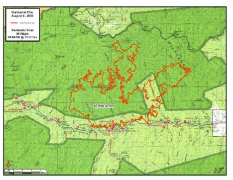
Situation as of 08/05/08 6:00 PM
Total Personnel: 322
Size: 32,590 acres
Percent Contained: 0%
Costs to Date: $2,050,000
No structures lost since 8/3. Yesterdays evacuations remain in place. Evacuations initiated today at Goff Creek and Libby Creek summer home groups. Evacuation re-established at the Elephant Head Resort.
A large plume column began building at 11:00am on the W end of the fire with activity continuing all day; growing to the S and W. Fire is now 6 miles from E entrance to Yellowstone NP.
***************
Situation as of 08/04/08 6:00 PM
Total Personnel: 288
Size: 31,050 acres
Percent Contained: 0%
Costs to Date: $1,370,000
Fire made a 9000+ acre run to the Northeast yesterday evening after 1900. The former Sweetwater Resort and a USFS structure were destroyed during the run. Evacuations continue. Strong winds anticipated.
***************
Update: The MMA (Maximum Manageable Area, or desired incineration zone) has been announced. It is 417,000 acres (652 sq miles) and includes public and private properties north and south of Highway 14. No map of the MMA was issued.
Situation as of 08/03/08 5:00 PM
Total Personnel: 200
Size: 21,995 acres
Percent Contained: 0%
Costs to Date: $1,000,000
Evacations are underway for the Elephant Head, Absaroka Lodge and summer cabins in Moss Creek. Fire came down to highway from the Sweetwater Creek drainage threatening cultural resources. Temporary road closure on the North Fork occurred.
Team transition to Type II (Angel) will occur at 1800 hrs. WFU is still main strategy. Hahnenberg will remain committed to complete stage 3 WFIP. One million dollars worth of “resource benefit” has been inflicted to date. Taxpayers, residents, visitors ecstatic. Numerous signs out in Cody WY, “Thanks for the Benefits.”
***************
Situation as of 08/02/08 5:00 PM
Total Personnel: 142
Size: 15,529 acres
Percent Contained: 0%
Costs to Date: $475,000
Evacuations are underway for the Elephant Head, Absaroka Lodge, and summer cabins in Moss Creek. Fire may have spotted over the North Fork.
Fire out of control. Firestorm, pluming. 100% mortality of forest. Threats to structures. Shut down of recreation. Despite that, Shoshone NF has announced that WFU is still main strategy. Hahnenberg FUM remains committed to complete stage 3 Wildfire Use Plan, even as the fire rages outside the previously designated Maximum Manageable Area.
Dimwit Shoshone Forest Supervisor Becky Aus, pictured [here], is legally responsible.
***************
Situation as of 08/01/08 5:00 PM
Total Personnel: 142
Size: 9,560 acres
Percent Contained: 0%
Costs to Date: $323,786
As predicted (below), the Gunbarrel WFU Fire is now close to 10,000 acres. Fire may breach the non-reported MMA this evening or overnight. Evacautions are underway for multiple lodges and homes within the North Fork area.
Fire managers are currently re-evaluating complexity analysis and developing Management Action Plans for appropriate management response. [sic - no kidding, that's what the report said, although I corrected their misspellings. Interpretation: the WFU idea has failed catastrophically. Another Let It Burn fire is blowing up. - Ed]. Two helicopters, 5 engines, and 50 firefighters have no chance of affecting this fire in any manner.
Fire is running, spotting and crowning downhill in the drainage of the North Fork. Fire is moving N and NE with runs up and down drainages, and creating significant growth toward the S as well.
Red Flag Warning for strong winds again tomorrow.
***************
Situation as of 07/31/08 5:00 PM
Total Personnel: 70
Size: 7,844 acres
Percent Contained: 0%
Maximum Manageable Area: not reported
Est date of containment: none
Red Flag Warning for strong winds today, 10 to 15 MPH increasing to 25 TO 30 MPH in the afternoon.
And thar she blows. Still no plan except let ‘er burn. Should be 10,000+ acres by evening tomorrow. Personnel in grave danger given the capabilities of the fire managers.
***************
Situation as of 07/30/08 5:00 PM
Total Personnel: 60
Size: 4,701 acres
Percent Contained: 0%
Maximum Manageable Area: not reported
Est date of containment: none
Continue to evaluate threats to MMA and developing Management Action Plans for appropriate management response. Meanwhile fire has quadrupled in size in two days.
Incident Command Post located at the Supervisors Office of the Shoshone National Forest, 40 miles away in Cody, WY. Shoshone NF was site of infamous Little Venus burnover of a Fire Use Module in 2006. No LCES led to near fatalities to 10 personnel.
***************
Situation as of 07/29/08 5:30 PM
Total Personnel: 28
Size: 2,103 acres
Percent Contained: 0%
Beginning WFIP Stage III process [they plan to make a plan]. Continue to evaluate threats to MMA and developing management action plans for appropriate management response. [Maximum Manageable Area indeterminate and subject to govt. functionary whim. The response chosen has been to watch gape-jawed as a few thousand acres per day are consumed by the fire. Eventually many $millions will be spent on a megafire and on the aftermath, damage that will last for decades].
Fire spotting ahead of fire front from wind-blown embers. Crown fire in forested areas. Fire spreading up side drainages in all directions.
***************
Situation as of 07/28/08 5:00 PM
Total Personnel: 14
Size: 800 acres
Percent Contained: 0%
Hannenberg’s Fire Use team has been ordered. FUT will assume control of the fire at 0600 07/29/2008.
Continue to monitor and take action if fire moves down drainage toward North Fork Shoshone River (Hwy 14) corridor. Fire backing into the wind in heavy timber and spotting to the east.
262 Fire
Location: 10 miles NW of Othello, Adams Co., WA
Specific Location: Columbia National Wildlife Refuge, Lat 46° 58´ 17″ Lon 119° 15´ 59″
Date of Origin: 07/27/2008
Cause: Under investigation
Situation as of 07/29/08 4:30 PM
Total Personnel: 84
Size: 6,054 acres
Percent Contained: 100%
Demob and turn over command to Local Type 4 Organization
***************
Situation as of 07/28/08 noon PM
Total Personnel: 133
Size: 6,000 acres
Percent Contained: 75%
Road closures on Highway 262, H Road and Morgan Lake Road until 2000 yesterday evening. Soda Lake campground and Soda Lake Dam evacuated until 7/29 then re-evaluate.
***************
Situation as of 07/27/08 10:00 PM
Total Personnel: 104
Size: 4,500 acres
Percent Contained: 40%
Soda Lake Campground (1 mi S of O’Sullivan Dam, Potholes Reservoir) evacuation and road closures.
Fire is currently under investigation but is believed to be human caused. Two SEAT aircraft supported initial attack activities. Active fire activity with 15 - 20 foot flame lengths.
Harley Fire
Location: 3 miles west of Neihart, Cascade Co., MT
Specific Location: Lewis & Clark NF, Lat 46° 55´ 53″ Lon 110° 47´ 59″
Date of Origin: 07/26/2008
Cause: lightning
Situation as of 08/02/08 6:00 PM
Total Personnel: 30
Size: 167 acres
Percent Contained: 80%
Costs to Date: $1,127,799
Demobilization of resources. All road closures and evacuations will be lifted by midnight.
***************
Situation as of 08/01/08 4:30 PM
Total Personnel: 75
Size: 167 acres
Percent Contained: 81%
Costs to Date: $1,066,813
Evacuation order for the Harley Creek residences, Harley Creek road closure, lifted at 2000 today.
Moved containment back to 8/10/2008 due to terrain and safety factors that made it impossible to line a segment of the fire’s perimeter.
***************
Situation as of 07/31/08 6:00 PM
Total Personnel: 105
Size: 167 acres
Percent Contained: 59%
Costs to Date: $1,016,218
Evacuation still in place. Anticipate lifting road closure on 8-3-2008. 2 crews reassigned to Cascade fire on 7/31/2008.
***************
Situation as of 07/30/08 6:00 PM
Total Personnel: 143
Size: 167 acres
Percent Contained: 51%
Costs to Date: $884,799
Lines have held during afternoon wind event. Perimeter of fire in Harley Creek (Div R) has not been staffed. Fire is burning into natural barriers and will be monitored using remote camera. Suppression action utilizing helicopter bucket work will be utilized if necessary
***************
Situation as of 07/29/08 6:00 PM
Total Personnel: 112
Size: 167 acres
Percent Contained: 44%
Costs to Date: $740,000
Voluntary evacuations still in effect.
Containment line was completed on NE and SW perimeters into Harley Creek.
***************
Situation as of 07/28/08 5:00 PM
Total Personnel: 140
Size: 167 acres
Percent Contained: 10%
Costs to Date: $500,000
Voluntary evacuations still in effect.
Line construction on N and W perimeters. Heli bucket work on S perimeter.
***************
Situation as of 07/27/08 5:00 PM
Total Personnel: 128
Size: 147 acres
Percent Contained: 10%
Residents in Harley Creek were voluntarily evacuated yesterday.
Spread of fire was checked with retardant and helicopter bucket work. Dozer and handline construction was started.
Parmenter Creek Fire
Location: 1.5 miles west of Libby, Lincoln Co., MT
Specific Location: Lat 48° 23´ 6″ Lon 115° 36´ 3″
Date of Origin: 07/26/2008
Cause: Under investigation
Situation as of 07/30/08 8:00 PM
Total Personnel: 121
Size: 130 acres
Percent Contained: 100%
Costs to Date: $813,437
Patrol and continue mop up operations.
***************
Situation as of 07/29/08 7:30 PM
Total Personnel: 170
Size: 130 acres
Percent Contained: 80%
Costs to Date: $605,000
No additional fire spread today. Spot fires were found and contained.
***************
Situation as of 07/28/08 7:00 PM
Total Personnel: 170
Size: 130 acres
Percent Contained: 60%
Costs to Date: $300,000
Mark Grant’s North Idaho Type 2 IMT took over fire operations yesterday. Two additional crews were received and put out on the fireline. One helicopter was used to suppress flare ups. Line was completed on the entire perimeter of the fire.
No additional fire spread. Spot fires were found and contained. The reduction in acreage is due to more accurate mapping of the fire perimeter.
***************
Situation as of 07/27/08 5:00 PM
Total Personnel: 96
Size: 150 acres
Percent Contained: 40%
Utilized 3 SEAT’s, 1 heavy AT, 2 helicopters to help contain active west flank. Requested 2 additional crews and Type 2 team. Inbriefing scheduled for 0900 7/28 in Libby.
SW winds with gust to 20 mph.
Cascade Fire
Location: 10 miles west of Red Lodge, Carbon Co., MT
Specific Location: Custer NF, Beartooth RD, Rock Creek area, Lat 45° 10´ 24″ Lon 109° 26´ 22″
Date of Origin: 07/26/2008
Cause: Under investigation
Situation as of 08/12/08 6:45 PM
Total Personnel: 85
Size: 10,173 acres
Percent Contained: 85%
Costs to Date: $8,398,760
More hot spots starting show up with return of warmer and drier weather.
Transfer of command from McBratney’s Type 3 Team to Buhl’s Type 3 team will occur at 0600 tomorrow. Demob continues. This will be the last update to the 209 unless significant events occur. Information and updates on the fire will be available at the Beartooth Ranger District starting on 8/13.
***************
Situation as of 08/11/08 5:00 PM
Total Personnel: 124
Size: 10,173 acres
Percent Contained: 85%
Costs to Date: $8,283,593
Bucket work on Division Y today. Rehab of handline work was done in A and B today. Engines continued mop-up along the West Fork of Rock Creek today. Transition to a smaller team to work with the District scheduled for 8/13. Tumble Creek was monitored by air. Demob continues.
***************
Situation as of 08/10/08 5:00 PM
Total Personnel: 109
Size: 10,173 acres
Percent Contained: 85%
Costs to Date: $8,169,091
***************
Situation as of 08/09/08 5:00 PM
Total Personnel: 136
Size: 10,173 acres
Percent Contained: 85%
Costs to Date: $8,060,480
Light rain over parts of the fire today. Engines worked along West Fork Rock Creek Road mopping up. Assisted Tumble Creek Incident with Palm IR flight today and GPS-ed interior hotspots.
As per the long term plan, the west and southwest sides of the fire will be allowed to burn into natural containment areas.
***************
Situation as of 08/08/08 5:00 PM
Total Personnel: 175
Size: 10,173 acres
Percent Contained: 85%
Costs to Date: $7,903,895
Size of the Area closure in the West Fork of Rock Creek has been reduced. Crews are continuing to mop-up. As per the long term plan, the west and southwest sides of the fire will be allowed to burn into natural containment areas.
***************
Situation as of 08/07/08 6:00 PM
Total Personnel: 228
Size: 10,173 acres
Percent Contained: 85%
Costs to Date: $7,755,000
Structures Destroyed: 5 residences (no additional)
Interior creeping and smoldering of unburned pockets of fuel. Continued mop up and patrol.
***************
Situation as of 08/06/08 5:30 PM
Total Personnel: 293
Size: 10,173 acres
Percent Contained: 85%
Costs to Date: $7,340,000
As per the long term plan, the W and SW side of the fire will be allowed to burn into natural containment areas.
***************
Situation as of 08/05/08 5:00 PM
Total Personnel: 429
Size: 10,173 acres
Percent Contained: 75%
Costs to Date: $7,060,000
Crews are continuing to mop up and secure line. Dozer lines along controlled perimeter are being rehabbed and structure protection equipment has been removed in most areas. Demob or reassignment in progress for many resources.
***************
Situation as of 08/04/08 5:00 PM
Total Personnel: 638
Size: 10,173 acres
Percent Contained: 66%
Costs to Date: $6,530,000
Line construction completed along uncontained perimeter in the Basin Creek drainage and on E flank to the N of the Basin Creek campground. Continuing to patrol and monitor fire’s spread into natural containment barriers to the W and S.
***************
Situation as of 08/02/08 3:30 PM
Total Personnel: 748
Size: 10,071 acres
Percent Contained: 33%
Costs to Date: $4,810,000
A Long Term Implementation Plan identifying long range fire management strategies, values at risk, and contingency actions was completed today in cooperation with local, county, state and federal officials.
Fire spread has been secured on north flank with control lines and natural barriers and crews are in mop up phase. Divisions on north flank will release some resources timing out and other resources will be shifted to divisions where active fire behavior continues. Helicopters and retardant being utilized to assist crews with line construction on northeast, east and south flanks.
***************
Situation as of 08/01/08 3:30 PM
Total Personnel: 747
Size: 9,701 acres
Percent Contained: 31%
Costs to Date: $4,000,000
Mandatory evacuation of the Grizzly Peak Subdivision has been lifted. Residents are still on alert. Structure protection is in place at the Red Lodge Mountain Ski Resort and residential areas.
Successful burnout of control lines in the Basin Creek drainage occurred last night and early this morning. High winds caused some spotting over dozer lines on E flank. Crews and water support continue to pick up spot fires. Active fire behavior with individual and group torching with moderate rates of spread and mid-range spotting especially at higher elevations where fire is being impacted by strong winds.
***************
Situation as of 07/31/08 4:30 PM
Total Personnel: 692
Size: 9,411 acres
Percent Contained: 10%
Costs to Date: $3,250,000
Crews and helicopters are focused on containing numerous spot fires on the northeast corner of the fire caused by yesterday’s wind event. Red Flag Warning for more winds today, 10 to 15 MPH increasing to 25 TO 30 MPH in the afternoon.
***************
Situation as of 07/30/08 5:00 PM
Total Personnel: 692
Size: 7,539 acres
Percent Contained: 5%
Costs to Date: $2,285,000
Structures Destroyed: 5 residences
A Red Flag warning has been issued for the fire area for low RH’s and high winds associated with a cold front passage this evening. Fire showing significant increase in activity on the East Flank due to high winds. The Structure Protection Group at Red Lodge Mountain Ski Resort has been put on alert and non essential personnel have been evacuated. Cold front passage predicted to occur around 2000 this evening.
Similar “Palouse” winds are expected on a weekly basis for the two months. All ID, MT, and WY fire managers should be aware.
***************
Situation as of 07/29/08 5:00 PM
Total Personnel: 496
Size: 5,936 acres
Percent Contained: 5%
Costs to Date: $1,250,000
Structures Destroyed: 5 residences
The Custer National Forest has issued a Fire Area Closure order that includes most of the trails and back country in the West Fork drainage. A mandatory evacuation continues for the Grizzly Peak subdivision.
***************
Situation as of 07/28/08 6:00 PM
Total Personnel: 279
Size: 5,800 acres
Percent Contained: 0%
A mandatory evacuation is in place for the Grizzly Peak subdivision. Voluntary evacuation for lower West Fork of Rock Creek residents.
Bennett’s Type I IMT assumed joint command this morning at 0600 with Carbon County.
**************
Situation as of 07/27/08 4:00 PM
Total Personnel: 116
Size: 3,500 acres
Percent Contained: 0%
Structures Destroyed: 5 residences
Evacuations of subdivisions still in progress. Continue evacuation of residences in West Fork drainage and Grizzly Peaks subdivision. Checking trails for hikers in the fire area. One helicopter assigned.
Update from Wildfire Today [here]: The Cascade fire on the Custer National Forest 8-10 miles west of Red Lodge, Montana has consumed 5,100 acres and has burned five summer homes in the Camp Senia area. The Grizzly Peaks subdivision about three miles west of Red Lodge was evacuated Sunday as a precaution. There are an estimated 40 to 50 homes in the subdivision. Another 40 to 50 homes west of Red Lodge were also evacuated. Bennett’s Type 1 Incident Management Team is assigned.
***************
Situation as of 07/26/08 9:00 PM
Total Personnel: 34
Size: 1,000 acres
Percent Contained: 0%
Extreme fire behavior caused the evacuation of several threatened residences. Evacuation of hikers, recreation residences, and campgrounds in the West Fork of Rock Creek to the Timber Crest Girl Scout Camp. Helicopter evacuations of 3 hikers took place.
Active crown fire with flame length 50 to 200 feet There was spotting 1/2 mile ahead of the fire. The fire is burning in heavy blowdown from wind storm in November 2007.
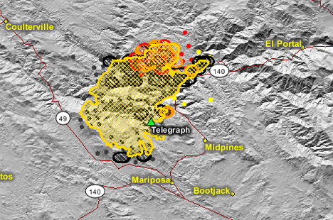
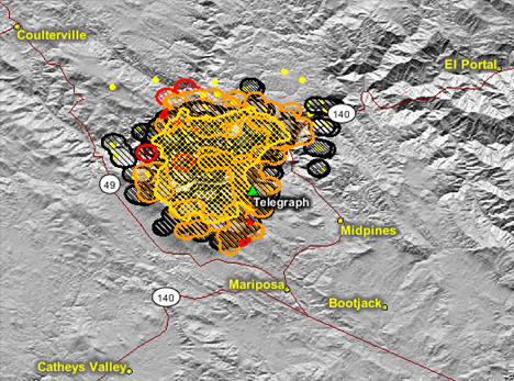
Telegraph Fire
Location: Merced River Canyon and watershed, Mariposa Co., CA
Specific Location: between Hwys 140 and 49, Midpines Area, Lat 37° 34´ 3″ Lon 119° 59´ 49″
Date of Origin: 07/25/2008
Cause: Human, target shooting
Situation as of 08/07/08 noon
Total Personnel: 336
Size: 34,091 acres
Percent Contained: 100%
Costs to Date: $38,350,000
Incident transitioned to local Unit at 1100 today, Aug 7.
***************
Situation as of 08/06/08 noon
Total Personnel: 907
Size: 34,091 acres
Percent Contained: 100%
Costs to Date: $37,620,588
Structures Destroyed: 30 residences , 100 outbuildings
After a thorough damage inspection there were more destroyed residences and outbuildings than originally reported.
Normal power was restored to Yosemite and El Portal. Minimal fire behavior observed. Strengthen and improve fire lines. Continue fire suppression repair.
***************
Situation as of 08/04/08 noon
Total Personnel: 1,926
Size: 34,091 acres
Percent Contained: 95%
Costs to Date: $34,822,386
A Local Assistance and Distribution Center has been set up by American Red Cross and Mariposa County. The Center is located at the Midpines Community Center.
Fire suppression repair and damage inspection has underway. PG&E plans on reenergizing the 70kv line this evening restoring normal power to Yosemite and El Portal.
***************
Situation as of 08/03/08 noon
Total Personnel: 3,974
Size: 34,091 acres
Percent Contained: 95%
Costs to Date: $32,090,376
Structures Destroyed: 21 residences , 33 outbuildings
A Local Assistance and Distribution Center has been set up by American Red Cross and Mariposa County. The Center is located at the Midpines Community Center. The incident will continue damage inspection over the next several days.
Approximately 35 percent of Suppression Repair is completed; the majority of repair left is on Federal Land. Significant demobilization of resources is in progress. PG&E is currently working to restore the damaged 70kv line to Yosemite and El Portal.
***************
Situation as of 08/02/08 noon
Total Personnel: 3,974
Size: 34,091 acres
Percent Contained: 90%
Costs to Date: $28,923,147
All evacuation orders and warnings were been lifted as of 2200 last night. Fire suppression repair is ongoing. Significant demobilization of resources is in progress.
***************
Situation as of 08/01/08 5:00 PM
Total Personnel: 4,541
Size: 34,034 acres
Percent Contained: 60%
The majority of residents were allowed to re-enter with the exception of Sherlock Road and parts of the community of Midpines. Road restrictions on Highway 140 East of Mariposa may affect access to Yosemite National Park. Visitors to Yosemite National Park are encouraged to explore other access routes. Various other road restrictions remain in place in and around the fire area. Sherlock Road remains closed to residents.
Active fire behavior has been isolated to the north and east flanks of the fire. Other areas are experiencing short runs in the interior fire area due to lower humidity and higher temperatures.
***************
Situation as of 07/31/08 7:00 PM
Total Personnel: 4,427
Size: 33,705 acres
Percent Contained: 40%
Structures Destroyed: 21 Residences and 33 Outbuildings
Cost to Date: $18.8 million
The communities of Midpines, Greeley Hill and Coulterville are under an evacuation advisory.
Hwy 140 will have various restrictions East of Mariposa. As of 12 p.m. the following roads are in the evacuation area: Texas Hill Rd., Dogtown Rd from Texas Hill Rd to Schilling Rd., Schilling Rd to Hwy 49N, Mikleoaks Rd. with road closure beginning at Hwy 49N.
***************
Situation as of 07/30/08 3:00 PM
Total Personnel: 3,792
Size: 32,063+ acres (not updated but the fire has grown ~1,000 acres since last report, according to satellite imagery, see below)
Percent Contained: 40%
Structures Destroyed: 21 Residences and 33 Outbuildings
Cost to date: $15 million
Hwy 140 has various restrictions East of Mariposa. As of 12 p.m. the following roads are in the evacuation area: Texas Hill Rd, Dogtown Rd from Texas Hill Rd to Schilling Rd, Schilling Rd to Hwy 49N, Mykleoaks Rd with road closure beginning at Hwy 49N.
Two Incident Command Teams employing 443 Fire Engines, 74 Hand Crews, 65 Dozers, 39 Watertenders, 13 Helicopters, 12 Airtankers. [Quite an array of equipment, possibly some sort of record for a fire this size. CalFire has pulled out all stops, which we approve of and salute - Ed].
Map image courtesy Firefighter Blog [here]
****************
Situation as of 07/30/08 7:00 AM
Total Personnel: 3,790
Size: 32,063 acres
Percent Contained: 20%
Structures Destroyed: 21 Residences and 32 Outbuildings
Cost to date: $13.9 million
Mandatory Evacuations: Various roads between Mariposa, Midpines and Greeley Hill.
Evacuation Warnings: Parts of the communities of Mariposa, Midpines, Greeley Hill, Coulterville, and Briceburg.
Partial and/or complete closure of Hwy 140 leading to the main entrance to Yosemite National Park.
***************
Situation as of 07/29/08 7:00 AM
Total Personnel: 3,458
Size: 29,600 acres
Percent Contained: 10%
Structures Destroyed: 25 Residences and 27 Outbuildings
Cost to date: $9,096,147.00
A mandatory evacuation for the Midpines Community is in effect. An evacuation advisory is in effect for all residences in the immediate fire area; which includes communities East of North Highway 49 at Mykleoaks Road south to the Highway 140 junction. This also includes communities west of Highway 140 from Mariposa north to Briceburg.
Evacuation Center: Mariposa Elementary School – 5044 Jones Street, Mariposa.
Animal Evacuations: Contact the animal evacuation hotline at 209-966-3615.
The fire is making major runs in all directions thru thick stands of Manzanita, Chamise, and Oak. Extreme fire behavior was observed with flames lengths of up to 100 feet reported. Similar burning conditions are expected in the next 24 hours. The fire is moving into the Sierra and Stanislaus Forest, affecting 70kv transmission line providing power to Yosemite Valley. A firing operation in the Dogtown area may generate visible smoke over the next 24 hours.
***************
Situation as of 07/28/08 5:00 PM
Total Personnel: 3,173
Size: 26,130 acres
Percent Contained: 10%
Structures Destroyed: 12 Residences and 27 Outbuildings
As of 5 p.m. the following roads are in the evacuation area: Texas Hill Rd., Dogtown Rd from Texas Hill Rd to Schilling Rd., Schilling Rd to Hwy 49N, Mykleoaks Rd. with road closure beginning at Hwy 49N.
A community meeting will be held on July 28, 2008 at 7:00 p.m. at the Mariposa High School Gymnasium located at 5074 Old Highway North, Mariposa.
Note: some of the above info conflicts slightly with info received earlier. The above info is official, the other was unofficial.
Note #2: unofficially, the unofficial info is better. The unofficial info is that as many as 25 residences have been destroyed, and that fire acreage actually DID increase between 6:30 AM and 5:00 PM today. We shall see in the morning what the official updates say.
***************
Situation as of 07/28/08 4:30 PM
Total Personnel: 3,173
Size: ~30,000 acres
Percent Contained: 10%
Structures Destroyed: ~16 residences and 30+ outbuildings
An evacuation order is in place for the Midpines community. Various roads between Mariposa, Midpines and Greeley Hill are under a mandatory evacuation. A pre-evacuation advisement was issued to the communities of Mariposa, Midpines, Briceburg, Greeley Hill, Coulterville, Bear Valley, and Mt. Bullion Conservation Camp.
Evacuation warnings and/or orders are in place for residences in the immediate area of the fire.
An Evacuation Center has been established at Mariposa Elementary School, 5044 Jones St, Mariposa. A Community Meeting is scheduled for tonight at Mariposa High School, hour unspecified.
Hwy 140 is closed 3 miles E of Briceburg. The power to Yosemite Valley has been shut down for powerline safety reasons. The water supply system for the Mariposa Public Utility District is threatened.
***************
Situation as of 07/28/08 6:30 AM
Total Personnel: 2,543
Size: 26,130 acres
Percent Contained: 10%
Structures Destroyed: 12 residences and 27 outbuildings
An evacuation order is in place for the Midpines community.
Evacuation warnings are in place for residences in the immediate area of the fire, which include the communities east of North Highway 49 at Mykleoaks Road south to the Highway 140 junction and communities west of Highway 140 from Mariposa north to Briceburg, including Greenley Hill, Coulterville, Bear Valley, and Mt. Bullion Camp.
Evacuation Center at Mariposa Elementary School, 5044 Jones St, Mariposa. A Community Meeting is being planned for night at the Mariposa High School.
***************
Situation as of 07/27/08 5:00 PM
Evac Orders (this is the best info I have at this time. If you have better info, please advise):
Evacuation order is in place for the Midpines community and the following areas: Foran, Avoca Vale, Alta Vista, Grosjean, Lake View, Serpentine, Penny Royal, French Camp.
A hard closure is being requested for Jenkins Hill as numerous residents are sheltering in place. Whitlock and Blue Oak Ridge may or may not be under evacuation.
Evacuation warnings are in place for the communities east of North Highway 49 at Mykleoaks Road south to the Highway 140 junction and communities west of Highway 140 from Mariposa north to Briceburg. In addition, Dog Town Road, Texas Hill, Wagner Road, and Schilling Road, and Mt Bullion Camp may have received evacuation warnings.
The following areas are under pre-evacuation advisement: The N side of Hwy 49 from Mykleoaks Road to Hwy 140 and 49 North intersection [that's the four-way stop]; Hwy 140 North Areas to through the Midpines areas continuing to the Briceburg area.
Phone lines are down in many places, eliminating the possibility of reverse-911 warnings. Sheriff deputies may be going door to door to warn residents in evacuation areas (if they have not all ready packed up and left).
Latest reports state the fire is moving briskly north/northeast deeper into the Merced River canyon. Further evacuations are being contemplated by CalFire.
Evacuation centers are at the Mariposa High School and Mariposa Elementary School; for animals at the Mariposa Fairgrounds. Offers to shelter large animals may be found at Telegraph Fire Mariposa/Midpines web forum [here].
***************
Situation as of 07/27/08 2:00 PM
Total Personnel: 1,922
Size: 18,145 acres
Percent Contained: 0%
15 structures have been lost including 8 homes.
The northeast end of the community of Mariposa (Avaca Vale, French Camp and Penny Royal Roads) is being impacted by the fire at this time. A pre-evacuation advisement was issued to the communities of Midpines and Briceburg.
Active fire behavior is being observed in all directions primarily in the south and east flanks near the advisement areas. As of 2:00 pm satellite photos show a large plume of smoke from the fire being pushed by a wind out of the south. This would indicate that additional acres are most likely being consumed on the north side of the fire, east and southeast of Coulterville.
The national cable news channels are headlining the Telegraph Fire as a “Yosemite Fire”, but it is not near nor a threat to Yosemite. The fire is burning near and around Mariposa, (population of 17,000), 27 miles from Yosemite National Park (10 miles from El Portal, the Park entrance).
This information thanks to Ret. Capt. Mike at Firefighter Blog [here] and Bill Gabbert at Wildfire Today [here]
***************
Situation as of 07/27/08 9:00 AM
Total Personnel: 900+
Size: ~24,000 acres
Percent Contained: 0%
Fire expanded southward overnight. Now within 2 miles of Mariposa and Mt. Bullion according to GEOMAC mapping.
***************
Situation as of 07/26/08 9:00 PM
Total Personnel: 800+
Size: ~18,000 acres
Percent Contained: 2%
Evacuation Warning to 150 homes with potential for warning and advisory to 300 homes (update: 2000 homes threatened). If fire continues in its current paths, the communities of Mariposa, Coulterville, and Greely Hill will be impacted. The fire has the potential to overrun communities. Midpines on Highway 140 and Bear Valley on Highway 49 are the most vulnerable overnight. An evacuation center has been established at the Mariposa High School.
The Merced River BLM Wild and Scenic Area had significant fire spread there today. The fire is moving toward the boundaries of the Sierra and Stanislaus National Forests. Power has been lost in Yosemite Valley.
Fire on the north and south sides of the Merced River Canyon. Fire estimated to have grown from 1,000 to 18,000 acres today. For maps and latest updates see Firefighter Blog [here].
Yolla Bolly Complex Fires (Repost)
The Yolla Bolly Complex was originally named the June ABCD Complex [here]. On 6/29 these fires received a name change to Yolla Bolly Complex Fires. On 7/11, the Yolla Bolly 209 information was merged with the Lime Complex 209 information [here]. On 7/25 the complex was split off, and is now reporting on its own again.
Location: ~30 mi W of Red Bluff, Trinity, Tehema, Mendocino Cos., CA
Specific Location: Yolla Bolly Wilderness, Mendocino NF, Shasta-Trinity NF, Lat 40° 4´ 13″ Lon 122° 57´ 55″
Date of Origin: 06/21/08
Cause: Lightning
Situation as of 08/20/08 6:00 PM
Total Personnel: 145
Size: 89,994 acres
Percent Contained: 100% (reported, but 85-90% actual)
Costs to Date: not reported, est. $16,100,000
***************
Situation as of 08/19/08 6:00 PM
Total Personnel: 235
Size: 89,994 acres
Percent Contained: 100% (reported, but 85-90% actual)
Costs to Date: not reported, est. $15.8 million
***************
Situation as of 08/18/08 6:00 PM
Total Personnel: 253
Size: 89,994 acres
Percent Contained: 95%
Costs to Date: $15,400,000
***************
Situation as of 08/17/08 6:00 PM
Total Personnel: 297
Size: 89,389 acres
Percent Contained: 95%
Costs to Date: $15,200,000
***************
Situation as of 08/16/08 6:00 PM
Total Personnel: 311
Size: 89,389 acres
Percent Contained: 95%
Costs to Date: $15,100,000
Responsible official: Mendocino NF Forest Supervisor Tom Contreras
Phone Number: (530) 934-3316
***************
Situation as of 08/15/08 6:00 PM
Total Personnel: 320
Size: 88,515 acres
Percent Contained: 95%
Costs to Date: $14,700,000
Two Crews have suppressed a 9 acre spot fire near the break at Divisions I/J that was identified during yesterdays patrol flight and Rappelling and Helitack resources staffed two more hot areas near the perimeter of Division J. IR confirms that the fires within the wilderness continue to grow daily.
***************
Situation as of 08/14/08 6:00 PM
Total Personnel: 334
Size: 87,987 acres
Percent Contained: 90%
Costs to Date: $14,600,000
The IR flight report indicated an intense heat near the line by the Division I/J break. The IA group was deployed to investigate and they found a burning snag several hundred feet inside the line. IA Crews are suppressing a 2 acre spot fire near the break at Divisions I/J that was identified during an afternoon recon flight. Currently the spot fire is causing no problems. IR confirms that the fires within the wilderness continue to grow daily.
Continued containment, mop-up, and rehab operations. Mop up and patrol in Divisions C and B. Fireline repair progressing on Trough Fire.
***************
Situation as of 08/13/08 6:00 PM
Total Personnel: 354
Size: 87,456 acres
Percent Contained: 90%
Costs to Date: $14,400,000
The fixed wing Air Attack ship assigned to this incident experienced a mechanical failure with it’s landing gear and sustained some damage upon landing at the Redding Airport. There were no injuries associated with this incident.
***************
Situation as of 08/12/08 6:00 PM
Total Personnel: 402
Size: 87,132 acres
Percent Contained: 90%
Costs to Date: $13,500,000
***************
Situation as of 08/11/08 6:00 PM
Total Personnel: 397
Size: 86,531 acres
Percent Contained: 90%
Costs to Date: $13,100,000
Lime Complex loaned a Skycrane which was utilized along with Martin Mars fixed wing for water drops. Short-range spots and numerous falling snags caused control problems on Division B slop over.
Active surface fire through heavy fuel concentrations, short crown runs, occasional torching and short range spotting up to 200 yds on isolated portions of the fire.
***************
Situation as of 08/10/08 6:00 PM
Total Personnel: 422
Size: 86,192 acres
Percent Contained: 90%
Costs to Date: $12,600,000
Slopover resulting from a burning snag began to grow in early afternoon. The slopover grew fast enough that additional air resources were needed. Lime Complex loaned 2 Skycranes and Martin Mars was utilized for water drops. By 1730 three handcrews were on scene and will work much of the night if terrain allows.
***************
Situation as of 08/09/08 6:00 PM
Total Personnel: 452
Size: 85,529 acres
Percent Contained: 90%
Costs to Date: $12,100,000
IR confirms that the fires within the wilderness continue to grow daily.
***************
Situation as of 08/08/08 6:00 PM
Total Personnel: 487
Size: 83,806 acres
Percent Contained: 90%
Costs to Date: $11,400,000
Rocky Mountain IMT2 will take command of the Yolla Bolly complex at 0600 on 8/9/07, and will have their ICP out of the Ruth Camp.
Burnout along Powell Ridge to the Trinity River last evening and continued reinforcement of that line throughout the day. This action closed the last open section of line, however there about 10,000 acres of internal unburned area between the Yellow, Vinegar and Grouse Fires.
Grouse Fire 4,241 acs 90% contained. Vinegar Fire 45,255 acs 90% contained. Yellow Fire 30,624 acs 90% contained.
***************
Situation as of 08/07/08 6:00 PM
Total Personnel: 553
Size: 82,259 acres
Percent Contained: 75%
Costs to Date: $10,900,000
All operational resources have been moved to Ruth Camp. Larsen’s Northern Rockies IMT inbriefed Pete Blume’s Rocky Mountain IMT2 at 0800 this morning for a Transfer of Command. Blume’s Team will take command of the Yolla Bolly complex at 0600 on 8/9/07, and will have their ICP out of the Ruth Camp.
***************
Situation as of 08/06/08 6:00 PM
Total Personnel: 545
Size: 81,094 acres
Percent Contained: 70%
Costs to Date: $10,200,000
***************
Situation as of 08/05/08 10:00 PM
Total Personnel: 568
Size: 79,629 acres
Percent Contained: 60%
Costs to Date: $9,200,000
The fire was active again today on the southern perimeter of the Grouse Fire. Operations continued to cleanup unburned islands along Dead Puppy ridge to tie in the Grouse and Yellow Fires. A control line has been completed from the head of the Grouse Fire up Powell Ridge, and the burn plan has been prepared
***************
Situation as of 08/03/08 6:00 PM
Total Personnel: 562
Size: 77,918 acres
Percent Contained: 50%
Costs to Date: $8,200,000
Initiated burnout between the head of the Grouse Fire and the Yellow Fire along Dead Puppy Ridge. Active ground fire through heavy fuel concentrations and within the Dead Puppy Ridge burnout, short uphill runs, isolated and group torching, and short range spotting.
***************
Situation as of 08/02/08 6:00 PM
Total Personnel: 547
Size: 77,006 acres
Percent Contained: 48%
Costs to Date: $7,500,000
Burnout operations on the head end of the Grouse fire between Dead Puppy Ridge and the Yolla Bolly, Middle Eel Wilderness boundary. Prep for burnout operations between the Grouse Fire and the head of the Vinegar Fire. Crews will continue to coyote spike as they progress further into the wilderness, and to facilitate early evening burnout operations.
***************
Situation as of 08/01/08 6:00 PM
Total Personnel: 508
Size: 75,648 acres
Percent Contained: 45%
Costs to Date: $7,000,000
IR confirms that the fires within the wilderness continue to grow daily.
***************
Situation as of 07/31/08 11:00 PM
Total Personnel: 570
Size: 75,091 acres
Percent Contained: 40%
Costs to Date: not updated, est. $6.5 million
Seasonal curing of the vegetation may increase fire behavior, and areas that have served as a barrier may begin to carry fire. Vegetation curing combined with the mosaic nature of the burn, and the potential for internal burning and re-burning, could contribute the potential for large fire growth. Heavy smoke continues to impact local and regional communities, and can restrict the use of aviation resources for fire suppression and support. Terrain is steep and inaccessible, and safety zones are limited. Due to inaccessibility and long travel times, most operational resources are in remote spike camps and information and communications with ICP are a challenge.
***************
Situation as of 07/30/08 6:00 PM
Total Personnel: 571
Size: 73,516 acres
Percent Contained: 35%
Costs to Date: $6,000,000
Larsen’s Northern Rockies IMT presented the Strategic Implementation Plan to the Shasta-Trinity National Forest, the Mendocino National Forest and Area Command at 1430 this afternoon. Note that fire has been burning since June 21.
***************
Situation as of 07/29/08 6:00 PM
Total Personnel: 504
Size: 72,367 acres
Percent Contained: 30%
Costs to Date: $5,700,000
Fire activity consisted of backing fire through heavy fuel concentrations, short up hill runs, isolated and group torching, and short range spotting.
***************
Situation as of 07/28/08 6:00 PM
Total Personnel: 490
Size: 70,635 acres
Percent Contained: 25%
Costs to Date: $4,950,000
Cold trailing with minimum impact suppression techniques are proposed for portions of the Vinegar and Yellow Fire with lighter fuels and areas that have experienced minimal movement the past couple of days. Reconniassance for potential contingency lines on portions of the Yellow Fire. A helitack crew will be inserted on the southeastern perimeter of the Vinegar Fire to hit isolated spots.
***************
Situation as of 07/27/08 6:00 PM
Total Personnel: 453
Size: 69,754 acres
Percent Contained: 20%
Costs to Date: $4,500,000
On 7/11 the Yolla Bolly fires were subsumed into the Lime Complex [here]. Now they are their own unique fire complex again. Note that during the two-week hiatus the fires have increased in size ten-fold.
Larsen’s IMT began working on a Strategic Implementation Plan for the complex this afternoon. Note that the fires have been burning for more than month.
Several crews and engines arrived at the incident yesterday, flight conditions for air support have improved, and operational resources made progress building fireline today.
Remaining uncontained fires: Grouse Fire 1,901 acres with 0% containment, Yellow Fire 25,556 acres with 15% containment, Vinegar Fire 38,611 acres and 25% contained. IR confirms that the fires within the wilderness continue to grow daily. With the predicted hot and dryer weather, the potential for fire to move out of the wilderness remains.
***************
Situation as of 07/25/08 6:00 PM
Total Personnel: 242
Size: 64,658 acres
Percent Contained: 15%
Costs to Date: $2,300,000
The Yolla Bolly Complex now consists of the Yellow Fire (24,074 acres and 10% contained), Vinegar Fire (35,238 acres and 10% contained, Grouse Fire (1,660 acres and 0% contained), and the Trough Fire (3,686 acres and 100% contained).
Dave Larson’s Northern Rockies Type 1 Incident Management Team assumed command at 0600 this morning. The NRIMT was instrumental in burning 800,000 acres of Idaho forests last summer. They do not fight fires, they backburn in massive acreage chunks.
Reconnaissance and control line construction for burnout operations on the south and southwest portions of the Yellow Fire and southern portions of the Vinegar Fire are planned for the next operational period.
Panther Fire
Location: 15 miles south of Happy Camp, Siskiyou Co., CA
Specific Location: Panther Ck, trib to Ukonom Ck, Klamath NF, Lat 41° 35´ 55″ Lon 123° 25´ 52″
Date of Origin: 07/22/2008 (reported 7/24)
Cause: lightning
Situation as of 09/09/08 6:00 PM
Total Personnel: 38
Size: ~28,500 acres (it is impossible to determine because the Panther Fire has been combined with the northern portion of the Ukonom Fire. Number juggling with intent to cover up and deceive taxpayers/forest owners has gone on with the Klamath NF fire reports)
Percent Contained: 75% (despite the massive spending that has gone on, no gain in containment has been achieved for weeks)
Costs to Date: $15,644,600 alleged
Yesterday’s shock and awe was on the southern portion of the Ukonom Fire, so somebody else’s problem. No actions taken by Panther Fire crews.
***************
Situation as of 09/09/08 6:00 AM
Total Personnel: 176
Size: ~28,500 acres (it is impossible to determine because the Panther Fire has been combined with the northern portion of the Ukonom Fire. Number juggling with intent to cover up and deceive taxpayers/forest owners has gone on with the Klamath NF fire reports)
Percent Contained: 75% (despite the massive spending that has gone on, no gain in containment has been achieved for weeks)
Costs to Date: no update, est. $16 million
Extremely active fire behavior in the English Peak area of the Ukonom fire. Snowslide Creek and adjoining unnamed creek are experiencing crown fire runs to the ridge tops. Fire also progressed downslope more aggressively than anybody involved expected. It was a shock and awe day at the Panther Fire.
***************
Situation as of 09/07/08 6:00 PM
Total Personnel: 214
Size: ~28,000 acres (it is impossible to determine because the Panther Fire has been combined with the northern portion of the Ukonom Fire. A whole lot of number juggling has gone on with the Klamath NF fire reports)
Percent Contained: 75% (despite the massive spending that has gone on, no gain in containment has been achieved for weeks)
Costs to Date: $15,520,368 (allegedly; these numbers have been seriously juggled, too)
The fire continues to back and flank out of some larger runs that developed yesterday. Almost all of the fire activity is in timber fuels [aka forest] with occasional torching and group torching when flanking fire is capable of making uphill runs. The main fire activity is between Yellow Jacket Ridge and English Peak and between Ukonom Lake and Bridge Creek.
Nearly two months of this fire and it is still killing forest, still uncontained, still costing hundreds of thousands of dollars a day.
The Panther Fire is a travesty. Klamath NF Supervisor Patricia Grantham is perhaps the WORST Forest Supervisor in the nation. She certainly has destroyed more forest and wasted more tax dollars in her short unhappy term than anyone in history.
***************
Situation as of 09/03/08 6:00 PM
Total Personnel: 214
Size: 24,954 acres (no update)
Percent Contained: 75%
Costs to Date: $15,189,492
Fire behavior increased today with larger areas of backing fire and increased torching. Most of the fire activity was still a backing fire in timber fuels with the fire creeping through down and dead heavies in areas with sparse fuels. Most of the fire activity is in the area from Ukonom Lake to Bridge Creek and the area north of Yellow Jacket Ridge.
***************
Situation as of 08/31/08 6:00 PM
Total Personnel: 156
Size: 24,954 acres (no update)
Percent Contained: 75%
Costs to Date: $15,037,553
Personnel on the Klamath Theater continued to re-evaluate management action points for a more flexible and cost efficient long term plan analysis for utilizing the WFDSS as the “test” pilot on the Klamath National Forest. The workforce has been organized into groups that provide manuverability to meet both the suppression and repair missions within the Theater. Division organizations are still active in geographic/operational assignments.
Cooler weather helped to moderate fire behavior. The fire continued to back slowly in timber fuels with minimal torching. The fire continued to slowly creep through acreas with discontinuous fuels. Most of the fire activity is between Ukonom Lake and Wooley Creek, with another area north of Yellow Jacket Ridge.
Note: the “Theater of War” metaphore is revolting. The very idea that the Klamath NF is “testing” megafire as a management tool is also revolting. Illegal incineration of national forests is the worst and most destructive plan in the history of the USFS. -Ed
***************
Situation as of 08/28/08 6:30 PM
Total Personnel: 188
Size: 24,954 acres (no update)
Percent Contained: 75%
Costs to Date: not reported, est. $15.3 million
Red Flag Warning remains in effect until 11AM Friday.
Achieved containment strategy for the non-wilderness portion of the fire 8/28. Will continue to monitor and confine the fire within the Marble Mountain Wilderness. Minimal action is being taken within the wilderness. Replacement crews are arriving.
***************
Situation as of 08/27/08 7:30 PM
Total Personnel: 88
Size: 24,954 acres (no update)
Percent Contained: 75%
Costs to Date: not reported, est. $15 million
Preparing for Fire Weather Watch (gusty winds and low RH) from 2300 hours tonight through 1100 hours August 29. Heat intensity concentrated northwest of Secret Lake near Onemile Creek and Flems Fork on the Panther Fire.
***************
Situation as of 08/24/08 6:00 PM
Total Personnel: 176
Size: 24,954 acres
Percent Contained: 75%
Costs to Date: $14,597,300
***************
Situation as of 08/23/08 6:00 AM
Total Personnel: 172
Size: 24,848 acres
Percent Contained: 75%
Costs to Date: $14,435,958
Crew was inserted into the wilderness (Div L) and began construction on segment of line south of Ukonom Lake to check eastward fire progression.
First they are in, then they are out, and now they are in again. They are suppressing, then not suppressing, then suppressing again. How did the fire get to wilderness anyway? It wasn’t in the wilderness when it started. But now, a month later, the fire has consumed 25,000 acres (39 sq miles) and it is in the wilderness. Now they suppress? Or not? Which is it? What in the Sam Hill are those wild and crazy government functionaries up to today? Would you buy a used car from these folks? Do you want them managing your watershed?
***************
Situation as of 08/22/08 6:00 PM
Total Personnel: 172
Size: 24,848 acres
Percent Contained: 75%
Costs to Date: $14,435,958
Minimal suppression action is being taken in the wilderness area.
***************
Situation as of 08/21/08 6:00 PM
Total Personnel: 175
Size: 24,756 acres (not updated)
Percent Contained: 75%
Costs to Date: $14,059,834
Fire continues to spread east into the Marble Mountain Wilderness area. A crew has been “inserted” into wilderness to construct a short segment of line utilizing MIST tactics.
***************
Situation as of 08/19/08 6:00 PM
Total Personnel: 211
Size: 24,756 acres
Percent Contained: 75%
Costs to Date: $13,710,425
Fire continues to spread east into the Marble Mountain Wilderness area. No suppression action is being taken.
***************
Situation as of 08/18/08 6:00 PM
Total Personnel: 256
Size: 24,414 acres
Percent Contained: 75%
Costs to Date: $13,508,000
Fire continues to spread east into the Marble Mountain Wilderness area. No suppression action is being taken.
***************
Situation as of 08/17/08 6:00 PM
Total Personnel: not reported
Size: 23,589 acres
Percent Contained: 73%
Costs to Date: $13,143,604
Active surface fire with short runs in the wilderness area. Interior burning with isolated torching elsewhere. Fire continues to spread east into the Marble Mountain Wilderness. No suppression action is being taken on fire within the wilderness area.
Responsible official: Klamath NF Forest Supervisor Patricia Grantham
Phone Number: (530) 842-6131
***************
Situation as of 08/16/08 6:00 PM
Total Personnel: 451
Size: 23,589 acres
Percent Contained: 70%
Costs to Date: $12,783,500
Firefighter fatalities to date: 1
Fire continues to move east into the Marble Mountain Wilderness area.
Responsible official: Klamath NF Forest Supervisor Patricia Grantham
Phone Number: (530) 842-6131
***************
Situation as of 08/15/08 6:00 PM
Total Personnel: 479
Size: 23,214 acres
Percent Contained: 60%
Costs to Date: $12,357,000
Harvey’s IMT2 will assume command of the Ukonom fire north of Wolley Creek tomorrow morning at 0700.
Test fire started in Div G for proposed burnout of small interior island between 14N22 road and cat line. Burnout will increase line depth on south side of the fire.
Suppression action is not being taken on portion of the fire within the Marble Mountian Wilderness area.
***************
Situation as of 08/14/08 6:00 PM
Total Personnel: 555
Size: 22,778 acres
Percent Contained: 50%
Costs to Date: $11,582,600
Crews continue to make good progress improving line, holding and moping up. Burnout initiated in Div K and will continue tomorrow if conditions permit.
***************
Situation as of 08/13/08 6:00 PM
Total Personnel: 601
Size: 22,385 acres
Percent Contained: 45%
Costs to Date: $11,082,000
Highway 96 opened to two-way traffic. Burnout in Div J completed securing NW corner of fire.
***************
Situation as of 08/12/08 6:00 PM
Total Personnel: 660
Size: 21,663 acres
Percent Contained: 41%
Costs to Date: $10,500,000
Highway 96 remains impacted with one way traffic control and piloting from Dillon Creek to Ti Bar.
Fire activity increased in Coon Creek drainage. Harvey’s Type 2 IMT assumed command at 0600. Burnout in the Titus Gap area completed.
***************
Situation as of 08/11/08 6:00 PM
Total Personnel: 864
Size: 21,018 acres
Percent Contained: 33%
Costs to Date: $9,500,000
Acreage in previous 209’s based on infrared interpretation of burned acreage. Acreage reduction due to more accurate GIS calculations. East Great Basin IMT continues to shadow and assumes to take command at 0600 tomorrow.
***************
Situation as of 08/10/08 6:00 PM
Total Personnel: 793
Size: 21,802 acres
Percent Contained: 28%
Costs to Date: $8,800,000
Highway 96 has been impacted with one way traffic control and piloting. Traffic control in place from Dillon Creek to Ti Bar.
The fire progressed east to Ukonom Lake. Single and group tree torching. Crews initiated direct attack on the slop over in Division K with helicopter support.
***************
Situation as of 08/09/08 6:00 PM
Total Personnel: 747
Size: 18,197 acres
Percent Contained: 23%
Costs to Date: $8,100,000
Hwy 96 has been impacted with lane closure down to one lane. Traffic control in place from Dillon Creek to TiBar. Burning operation to be completed by 10pm ending at Hwy 96 along the Klamath River.
***************
Situation as of 08/08/08 6:00 PM
Total Personnel: 751
Size: 14,402 acres
Percent Contained: 14%
Costs to Date: $7,500,000
Fire crossed into headwaters of Bishop Creek. Rolling rocks into the Klamath River forced closure to recreational river rafters.
Crews are working to limit spread into Elk Creek Watershed and are building a second contingency line to keep from fire from impacting Hwy 96.
***************
Situation as of 08/07/08 6:00 PM
Total Personnel: 751
Size: 12,659 acres
Percent Contained: 14%
Costs to Date: $6,800,000
Successful firing operations today on 14N22 and the hand line toward the Klamath River.
***************
Situation as of 08/06/08 6:00 PM
Total Personnel: 762
Size: 11,022 acres
Percent Contained: 9%
Costs to Date: $6,200,000
Fire was active today on the north side crossing Coon Hollow and the west side toward the Klamath River. Firing operations were also successful today on Ukonom Mountain and south of Ten Bear Mountain along 13N01.
***************
Situation as of 08/05/08 6:00 AM
Total Personnel: 794
Size: 9,806 acres
Percent Contained: 8%
Costs to Date: $4,800,000
Completed firing 3/4 mile on southern perimeter.
RED FLAG WARNING IN EFFECT FROM NOON TODAY TO MIDNIGHT PDT TONIGHT FOR THUNDERSTORMS WITH LITTLE RAIN
***************
Situation as of 08/03/08 6:00 PM
Total Personnel: 807
Size: 8,002 acres
Percent Contained: 5%
Costs to Date: $4,100,000
The fire made strong movement on the S end of the fire in McCash Creek. Otherwise, higher humidities moderated fire behavior limited the opportunity to initiate firing operations today.
***************
Situation as of 08/02/08 6:00 PM
Total Personnel: 782
Size: 7,115 acres
Percent Contained: 0%
Costs to Date: $3,200,000
Fire moved upslope toward Ukonom Mountain Lookout triggering Management Action Point that required initiating firing operation from the lookout to Lick Creek. Firing operation also started on the North side of fire from the Marble Mountain Wilderness Boundary to DP 30-6.
***************
Situation as of 08/01/08 6:00 AM
Total Personnel: 706
Size: 6,232 acres
Percent Contained: 0%
Costs to Date: $2,100,000
A remembrance service for Chief Daniel Packer was held at 1900 hours.
Fire crossed Ukonom Creek this afternoon and is moving toward the Ukonom Mountain Lookout. Completed line construction above Independence Creek on 15N17Y and continued line preparation on the south end near Ukonom Mountain and Ten Bear Mountain.
***************
Situation as of 07/31/08 6:00 AM
Total Personnel: 608
Size: 5,338 acres
Percent Contained: 0%
Costs to Date: $1,400,000
***************
Situation as of 07/30/08 6:00 AM
Total Personnel: 356
Size: 4,099 acres
Percent Contained: 0%
Costs to Date: $675,000
Continued coordination with the IMT managing the Ukonom and Siskiyou Complex Fires. Continued to support the Serious Accident Investigation Team.
***************
Situation as of 07/29/08 6:00 AM
Total Personnel: 356
Size: 2,056 acres
Percent Contained: 0%
CIIMT 1 (McGowan) transition complete with ICP located in Happy Camp. Coordination with the IMT managing the Ukonom and Siskiyou Complex Fires. Supporting the Serious Accident Investigation Team.
***************
Situation as of 07/28/08 6:00 AM
Total Personnel: 6
Size: 650 acres
Percent Contained: 0%
Fire spread being monitored
***************
Situation as of 07/27/08 11:00 PM
Total Personnel: not reported
Size: 554 acres
Percent Contained: 25%
Firefighter fatality confirmed as Daniel Packer, chief of East Pierce Fire & Rescue and past president of the Washington Fire Chiefs. He was overrun by the fire when the wind shifted unexpectedly.
Type 1 IMT (Dietrich) assumed command of Panther Fire at 0600 today. Tentative transfer of Command to Type 1 IMT (McGowan) 07/29/2008 at 0600. Coordination with Siskiyou County Sheriff’s Office, Serious Accident Investigation Team Support.
Steep terrain, rolling material, snags from ‘87 King Titus Fire, active fire movement with downhill progress driven by rolling material, large standing snags actively burning.
Update: firecrews have been pulled off the Panther Fire because of the impact the loss of Daniel Packer has had mentally and emotionally on his fellow firefighters.
***************
Firefighter fatality
An unidentified firefighter died Saturday 7/26 while working on the Panther Fire south of Happy Camp on the Klamath National Forest in northern California. There has been no official release of the person’s name at this time.
This follows the death of Andrew Palmer, a National Park Service firefighter who died on Friday, struck by a falling tree, and Robert Roland, a volunteer with the Anderson Valley Fire Department who collapsed on the fireline due to a heart attack on July 3 and died a few hours later. - from Wildfire Today [here]
Situation as of 07/25/08 4:00 PM
Total Personnel: 124
Size: 180 acres
Percent Contained: 25%
Direct attack, building handline and utilizing air support. Unlike the Ukonom Complex (32,266 acs last report) and the Siskiyou Complex Fires (54,657 acs last report), USFS managers decide to fight the Panther Fire. Expected containment date is next Friday but may be achieved much sooner.
No costs were reported but they are expected to be less than $1 million when this fire is out. In contrast, the Let It Burn fires in the same area have cost taxpayers over $40 million to date. Resources damages from the Let It Burn fires are roughly ten times that amount.
Basin Complex Fire (Reposted)
Location: Ventana, Los Padres NF, Monterey Co., CA
Specific Location: Lat 36° 12′ 37″; Lon 121° 44′ 22″
Date of Origin: 06/21/08
Cause: Lightning
Situation as of 07/27/08 6:00 PM
Total Personnel: 562
Size: 162,818 acres
Percent Contained: 100%
Cost to date: $76,096,015
The Basin Complex has been declared 100% contained. All the backburning has ceased. Firefighting crews are demobilizing. A Type 3 IMT will take over fire management next Tuesday.
The Basin/Indians Fire has now consumed 244,000 acres and is the 3rd LARGEST fire in California history. With more than $120,000,000 spent on fire “suppression,” it is now the MOST EXPENSIVE fire in California history, and the 2nd most expensive in U.S. history (the Biscuit Fire in Oregon in 2002 cost $150,000,000).
***************
Situation as of 07/25/08 6:00 PM
Total Personnel: 1,124
Size: 162,818 acres
Percent Contained: 79%
Cost to date: $73,456,092
The Basin/Indians Complex Fire now exceeds 244,000 acres and is officially the second largest fire in California since the 1800’s (the largest modern era fire was the 273,000 Cedar Fire in 2002, see [here]).
Yesterday USFS Chief Gail Kimbell visited the fresh desolation and marveled at the destruction her agency has wrought upon the Los Padres NF. Chief Kimbell hopes to burn every national forest in America to ashes in exactly the same fashion, before she is unceremoniously kicked to the curb.
***************
Situation as of 07/24/08 6:00 PM
Total Personnel: 1,415
Size: 149,924 acres
Percent Contained: 79%
Cost to date: $71,890,017
Structures Destroyed: 26 residences , 32 outbuildings
After more than a month the Basin Fire is still burning. Together with the contiguous Indians Fire, more than 230,000 acres (360 sq miles) of the Los Padres NF have been incinerated at a cost to taxpayers of nearly $115 million to date. Most of that acreage has been backburned deliberately, not to halt the fire but to burn out the landscape. The fresh desolation has been extended to private lands adjacent to the Los Padres NF, where federal firefighters have failed to assist homeowners in saving their homes.
In case after case, private homeowners have risked arrest to single-handedly fight the fires threatening their homes. The Tassajara Zen Center was abandoned by fire managers but monks fought the fire on their own and managed to save most of the buildings. Not even a single helicopter was dispatched to assist. In Big Sur volunteer firefighters who dodged roadblocks saved their own homes despite bellicose threats of arrest from federal fire officials. In Pine Valley Hot Shots “dropped off a nozzle” and then fled rather than assist homeowners.
The Basin Fire started as a lightning strike on June 21. It quickly grew to 40 acres. Firefighters from the Indians Fire were on the scene within minutes. The choice of the USFS was not to fight the fire, however, but to Let It Burn, encouraged by deliberate backburning. The Basin Fire continues to grow in 10,000 acre backburned chunks. The same “techniques” were used in the southern portion of the Los Padres NF last summer when the Zaca Fire incinerated more than 240,000 acres and cost more than $120 million to backburn. The Zaca Fire was the second largest fire in California since the 1800’s, and the most expensive in state history, but the Basin/Indians Complex may exceed it in acreage and cost.
Today backburning operations continued from Miller Canyon to the Los Padres Dam. The Carmel River watershed, water source to more than 100,000 people, has been roasted to the dirt. Massive erosion and flash floods are expected, damaging the water system for the entire Monterey Peninsula. Fire activity increased today, allegedly due to “higher temperatures and lower relative humidity” but actually because federal crews have set more acres on fire in the Carmel River watershed.
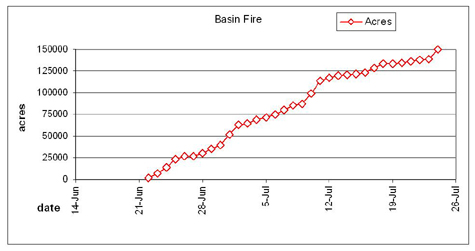
CA Fire Map Thursday 07/24 AM
Click map for larger image
California Summary 07/24/08
Total Fires at Peak: 2,093
Total Fires Contained: 2,062
Total Active Fires: 31
Total Acres Burned: 1,032,722 (1,614 sq miles)
These numbers are total fires and acres that have occurred from state, local and federal firefighting agencies beginning June 20, 2008.
Highway closures: Firefighters remind everyone to use extreme caution while driving on roads affected by fires. All major roads are now open. There may be some delays State Highways 70 and 299. Travelers are advised to seek current information on secondary road closures from local law enforcement. Click here for detailed road closures.
Evacuations: Areas of Shasta, Trinity and Humboldt counties are under evacuation orders at this time. Precautionary evacuation orders currently exist in areas of Monterey, Siskiyou and Trinity counties. Residents are advised to monitor their local fire situation, check with local law enforcement agencies for information, and be prepared to evacuate when necessary.Click here for detailed evacuation information.
Structures Destroyed : 158 residences, 1 commercial, 139 outbuildings.
