Telegraph Fire
Location: Merced River Canyon and watershed, Mariposa Co., CA
Specific Location: between Hwys 140 and 49, Midpines Area, Lat 37° 34´ 3″ Lon 119° 59´ 49″
Date of Origin: 07/25/2008
Cause: Human, target shooting
Situation as of 08/07/08 noon
Total Personnel: 336
Size: 34,091 acres
Percent Contained: 100%
Costs to Date: $38,350,000
Incident transitioned to local Unit at 1100 today, Aug 7.
***************
Situation as of 08/06/08 noon
Total Personnel: 907
Size: 34,091 acres
Percent Contained: 100%
Costs to Date: $37,620,588
Structures Destroyed: 30 residences , 100 outbuildings
After a thorough damage inspection there were more destroyed residences and outbuildings than originally reported.
Normal power was restored to Yosemite and El Portal. Minimal fire behavior observed. Strengthen and improve fire lines. Continue fire suppression repair.
***************
Situation as of 08/04/08 noon
Total Personnel: 1,926
Size: 34,091 acres
Percent Contained: 95%
Costs to Date: $34,822,386
A Local Assistance and Distribution Center has been set up by American Red Cross and Mariposa County. The Center is located at the Midpines Community Center.
Fire suppression repair and damage inspection has underway. PG&E plans on reenergizing the 70kv line this evening restoring normal power to Yosemite and El Portal.
***************
Situation as of 08/03/08 noon
Total Personnel: 3,974
Size: 34,091 acres
Percent Contained: 95%
Costs to Date: $32,090,376
Structures Destroyed: 21 residences , 33 outbuildings
A Local Assistance and Distribution Center has been set up by American Red Cross and Mariposa County. The Center is located at the Midpines Community Center. The incident will continue damage inspection over the next several days.
Approximately 35 percent of Suppression Repair is completed; the majority of repair left is on Federal Land. Significant demobilization of resources is in progress. PG&E is currently working to restore the damaged 70kv line to Yosemite and El Portal.
***************
Situation as of 08/02/08 noon
Total Personnel: 3,974
Size: 34,091 acres
Percent Contained: 90%
Costs to Date: $28,923,147
All evacuation orders and warnings were been lifted as of 2200 last night. Fire suppression repair is ongoing. Significant demobilization of resources is in progress.
***************
Situation as of 08/01/08 5:00 PM
Total Personnel: 4,541
Size: 34,034 acres
Percent Contained: 60%
The majority of residents were allowed to re-enter with the exception of Sherlock Road and parts of the community of Midpines. Road restrictions on Highway 140 East of Mariposa may affect access to Yosemite National Park. Visitors to Yosemite National Park are encouraged to explore other access routes. Various other road restrictions remain in place in and around the fire area. Sherlock Road remains closed to residents.
Active fire behavior has been isolated to the north and east flanks of the fire. Other areas are experiencing short runs in the interior fire area due to lower humidity and higher temperatures.
***************
Situation as of 07/31/08 7:00 PM
Total Personnel: 4,427
Size: 33,705 acres
Percent Contained: 40%
Structures Destroyed: 21 Residences and 33 Outbuildings
Cost to Date: $18.8 million
The communities of Midpines, Greeley Hill and Coulterville are under an evacuation advisory.
Hwy 140 will have various restrictions East of Mariposa. As of 12 p.m. the following roads are in the evacuation area: Texas Hill Rd., Dogtown Rd from Texas Hill Rd to Schilling Rd., Schilling Rd to Hwy 49N, Mikleoaks Rd. with road closure beginning at Hwy 49N.
***************
Situation as of 07/30/08 3:00 PM
Total Personnel: 3,792
Size: 32,063+ acres (not updated but the fire has grown ~1,000 acres since last report, according to satellite imagery, see below)
Percent Contained: 40%
Structures Destroyed: 21 Residences and 33 Outbuildings
Cost to date: $15 million
Hwy 140 has various restrictions East of Mariposa. As of 12 p.m. the following roads are in the evacuation area: Texas Hill Rd, Dogtown Rd from Texas Hill Rd to Schilling Rd, Schilling Rd to Hwy 49N, Mykleoaks Rd with road closure beginning at Hwy 49N.
Two Incident Command Teams employing 443 Fire Engines, 74 Hand Crews, 65 Dozers, 39 Watertenders, 13 Helicopters, 12 Airtankers. [Quite an array of equipment, possibly some sort of record for a fire this size. CalFire has pulled out all stops, which we approve of and salute - Ed].
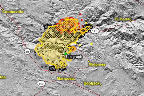
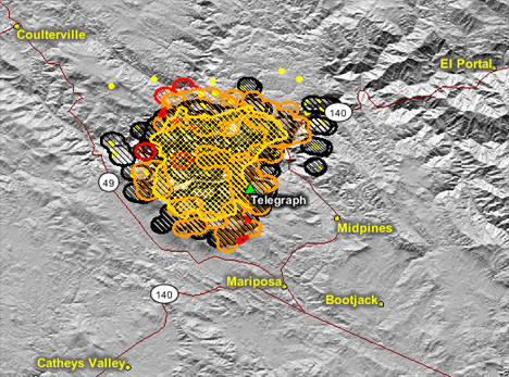
Map image courtesy Firefighter Blog [here]
****************
Situation as of 07/30/08 7:00 AM
Total Personnel: 3,790
Size: 32,063 acres
Percent Contained: 20%
Structures Destroyed: 21 Residences and 32 Outbuildings
Cost to date: $13.9 million
Mandatory Evacuations: Various roads between Mariposa, Midpines and Greeley Hill.
Evacuation Warnings: Parts of the communities of Mariposa, Midpines, Greeley Hill, Coulterville, and Briceburg.
Partial and/or complete closure of Hwy 140 leading to the main entrance to Yosemite National Park.
***************
Situation as of 07/29/08 7:00 AM
Total Personnel: 3,458
Size: 29,600 acres
Percent Contained: 10%
Structures Destroyed: 25 Residences and 27 Outbuildings
Cost to date: $9,096,147.00
A mandatory evacuation for the Midpines Community is in effect. An evacuation advisory is in effect for all residences in the immediate fire area; which includes communities East of North Highway 49 at Mykleoaks Road south to the Highway 140 junction. This also includes communities west of Highway 140 from Mariposa north to Briceburg.
Evacuation Center: Mariposa Elementary School – 5044 Jones Street, Mariposa.
Animal Evacuations: Contact the animal evacuation hotline at 209-966-3615.
The fire is making major runs in all directions thru thick stands of Manzanita, Chamise, and Oak. Extreme fire behavior was observed with flames lengths of up to 100 feet reported. Similar burning conditions are expected in the next 24 hours. The fire is moving into the Sierra and Stanislaus Forest, affecting 70kv transmission line providing power to Yosemite Valley. A firing operation in the Dogtown area may generate visible smoke over the next 24 hours.
***************
Situation as of 07/28/08 5:00 PM
Total Personnel: 3,173
Size: 26,130 acres
Percent Contained: 10%
Structures Destroyed: 12 Residences and 27 Outbuildings
As of 5 p.m. the following roads are in the evacuation area: Texas Hill Rd., Dogtown Rd from Texas Hill Rd to Schilling Rd., Schilling Rd to Hwy 49N, Mykleoaks Rd. with road closure beginning at Hwy 49N.
A community meeting will be held on July 28, 2008 at 7:00 p.m. at the Mariposa High School Gymnasium located at 5074 Old Highway North, Mariposa.
Note: some of the above info conflicts slightly with info received earlier. The above info is official, the other was unofficial.
Note #2: unofficially, the unofficial info is better. The unofficial info is that as many as 25 residences have been destroyed, and that fire acreage actually DID increase between 6:30 AM and 5:00 PM today. We shall see in the morning what the official updates say.
***************
Situation as of 07/28/08 4:30 PM
Total Personnel: 3,173
Size: ~30,000 acres
Percent Contained: 10%
Structures Destroyed: ~16 residences and 30+ outbuildings
An evacuation order is in place for the Midpines community. Various roads between Mariposa, Midpines and Greeley Hill are under a mandatory evacuation. A pre-evacuation advisement was issued to the communities of Mariposa, Midpines, Briceburg, Greeley Hill, Coulterville, Bear Valley, and Mt. Bullion Conservation Camp.
Evacuation warnings and/or orders are in place for residences in the immediate area of the fire.
An Evacuation Center has been established at Mariposa Elementary School, 5044 Jones St, Mariposa. A Community Meeting is scheduled for tonight at Mariposa High School, hour unspecified.
Hwy 140 is closed 3 miles E of Briceburg. The power to Yosemite Valley has been shut down for powerline safety reasons. The water supply system for the Mariposa Public Utility District is threatened.
***************
Situation as of 07/28/08 6:30 AM
Total Personnel: 2,543
Size: 26,130 acres
Percent Contained: 10%
Structures Destroyed: 12 residences and 27 outbuildings
An evacuation order is in place for the Midpines community.
Evacuation warnings are in place for residences in the immediate area of the fire, which include the communities east of North Highway 49 at Mykleoaks Road south to the Highway 140 junction and communities west of Highway 140 from Mariposa north to Briceburg, including Greenley Hill, Coulterville, Bear Valley, and Mt. Bullion Camp.
Evacuation Center at Mariposa Elementary School, 5044 Jones St, Mariposa. A Community Meeting is being planned for night at the Mariposa High School.
***************
Situation as of 07/27/08 5:00 PM
Evac Orders (this is the best info I have at this time. If you have better info, please advise):
Evacuation order is in place for the Midpines community and the following areas: Foran, Avoca Vale, Alta Vista, Grosjean, Lake View, Serpentine, Penny Royal, French Camp.
A hard closure is being requested for Jenkins Hill as numerous residents are sheltering in place. Whitlock and Blue Oak Ridge may or may not be under evacuation.
Evacuation warnings are in place for the communities east of North Highway 49 at Mykleoaks Road south to the Highway 140 junction and communities west of Highway 140 from Mariposa north to Briceburg. In addition, Dog Town Road, Texas Hill, Wagner Road, and Schilling Road, and Mt Bullion Camp may have received evacuation warnings.
The following areas are under pre-evacuation advisement: The N side of Hwy 49 from Mykleoaks Road to Hwy 140 and 49 North intersection [that's the four-way stop]; Hwy 140 North Areas to through the Midpines areas continuing to the Briceburg area.
Phone lines are down in many places, eliminating the possibility of reverse-911 warnings. Sheriff deputies may be going door to door to warn residents in evacuation areas (if they have not all ready packed up and left).
Latest reports state the fire is moving briskly north/northeast deeper into the Merced River canyon. Further evacuations are being contemplated by CalFire.
Evacuation centers are at the Mariposa High School and Mariposa Elementary School; for animals at the Mariposa Fairgrounds. Offers to shelter large animals may be found at Telegraph Fire Mariposa/Midpines web forum [here].
***************
Situation as of 07/27/08 2:00 PM
Total Personnel: 1,922
Size: 18,145 acres
Percent Contained: 0%
15 structures have been lost including 8 homes.
The northeast end of the community of Mariposa (Avaca Vale, French Camp and Penny Royal Roads) is being impacted by the fire at this time. A pre-evacuation advisement was issued to the communities of Midpines and Briceburg.
Active fire behavior is being observed in all directions primarily in the south and east flanks near the advisement areas. As of 2:00 pm satellite photos show a large plume of smoke from the fire being pushed by a wind out of the south. This would indicate that additional acres are most likely being consumed on the north side of the fire, east and southeast of Coulterville.
The national cable news channels are headlining the Telegraph Fire as a “Yosemite Fire”, but it is not near nor a threat to Yosemite. The fire is burning near and around Mariposa, (population of 17,000), 27 miles from Yosemite National Park (10 miles from El Portal, the Park entrance).
This information thanks to Ret. Capt. Mike at Firefighter Blog [here] and Bill Gabbert at Wildfire Today [here]
***************
Situation as of 07/27/08 9:00 AM
Total Personnel: 900+
Size: ~24,000 acres
Percent Contained: 0%
Fire expanded southward overnight. Now within 2 miles of Mariposa and Mt. Bullion according to GEOMAC mapping.
***************
Situation as of 07/26/08 9:00 PM
Total Personnel: 800+
Size: ~18,000 acres
Percent Contained: 2%
Evacuation Warning to 150 homes with potential for warning and advisory to 300 homes (update: 2000 homes threatened). If fire continues in its current paths, the communities of Mariposa, Coulterville, and Greely Hill will be impacted. The fire has the potential to overrun communities. Midpines on Highway 140 and Bear Valley on Highway 49 are the most vulnerable overnight. An evacuation center has been established at the Mariposa High School.
The Merced River BLM Wild and Scenic Area had significant fire spread there today. The fire is moving toward the boundaries of the Sierra and Stanislaus National Forests. Power has been lost in Yosemite Valley.
Fire on the north and south sides of the Merced River Canyon. Fire estimated to have grown from 1,000 to 18,000 acres today. For maps and latest updates see Firefighter Blog [here].
by Bonnie M.
Mariposa community members have started a fire information forum-type website at http://www.telegraphfire.wetpaint.com
From CalFire [here], July 26, 2008, 8:00 pm (yesterday evening)
Date/Time Started: June 25, 2008, 3:15 pm
County: Mariposa County
Location: Telegraph Road and Sherlock Road in the Midpines Area.
Acres Burned: 16,000 acres
Containment: 0% contained
Structures Threatened: 2,000 residences in the communities of Midpines, Mariposa, Greeley Hill, Coulterville, Bear Valley, and Mt. Bullion Camp
Evacuations: Evacuation order is in place for the Midpines community. Evacuation warnings are in place for residences in the immediate area of the fire. An evacuation center has been established at the Mariposa Elementry School.
CAL FIRE Incident Command Team #8 has taken command of the fire. Cooperating Agencies: CAL FIRE, Mariposa County Fire, Mariposa Sheriffs Department, BLM, USFS, CCC, and California Department of Corrections and Rehabilitation. Fire Information: (209) 966-4784 or (209) 966-4785
Resources Committed : 884 Total Resources (people): 1 AirAttack, 4 AirTankers, 3 Helicopters, 94 Engines, 20 Hand Crews, 24 Dozers, and 3 Watertenders.
Conditions: The fire is burning in the Merced River Drainage, on both sides of the river. The fire is burning with a rapid rate of spread. Accessibility problems due to steep, rocky and isolated terrain.
by Mark T.
Please note that the Telegraph Fire is burning in the Merced River Canyon. References to the Tuolumne River will cause undue anxiety. There are many miles to go up the North Fork of the Merced River before entering the Tuolumne River watershed.
Thank you, Mark. Correction made. The reference to the Tuolumne River came directly from the Southern California Geographic Area Coordination Center. However, they have been wrong before.
For the latest maps of the fire’s spread, see GEOMAC Wildfire Viewer, linked in the righthand sidebar. Those maps clearly show that the Telegraph Fire is in the Merced River canyon and watershed, many miles from the Tuolumne River, and headed south and east, not north, generally speaking.
In addition, the National Weather Service is predicting NW winds 7-14 mph in the afternoons and evenings, due to an onshore flow, prevailing most of the week.
by Tracy
I was wondering if anyone knows how close the fire is at Greely Hill. We have a new trailer on some land down the street from the new market. Thank you
For an excellent realtime, multiparty, on-the-scene discussion of specific homes and neighborhoods impacted by the Telegraph Fire, I highly recommend the Telegraph Fire Mariposa/Midpines Web Forum [here].
Questions regarding the condition of homes and the safety of residents are very well covered. This kind of service offered by web-savvy residents of the Mariposa region is a true advancement and a very commendable use of Internet technology. Kudos to all involved.
by Dave
Good evening. there are a few sites that will help with information on the Telegraph Fire. One is an active scanner link [here]
Another was put together by some great people up in Butte County who just did a darned good job updating info on the BTU Complex and are very good at providing resource information to local residents affected by the fire. The site is [here]
Another great site is this one which shows national forest resources for the Sierra Nat’l Forest and their assigned areas. All the units are listed, [here].
Good luck to all concerned and affected by this incident and God bless the fire personnel. — Dave

If you have any knowledge of the Mcguire estate on Sherlock Road and how far it is from the fire, please reply.