Where Oh Where Is Congress?
As the 2008 Fire Season heads into July like a runaway freight train, the question arises, where is Congress? Have our enlightened leaders noticed that their districts are aflame? Is megafire an election issue yet?
Take Howard P. (Buck) McKeon for instance. Buck represents the 25th District in California, which has had two whoofoos this year alone, the Honeybee WFU and the Clover WFU. The latter has been burning since May 31 and has cost the taxpayers $6 million so far. Has Buck noticed? Would you vote for somebody who takes your taxes and sets them on fire?
Or Sam Farr? Sam has represented Monterey County for 15 years. He is the son of Fred Farr, who was a state senator from the same locale for decades. Sam inherited his position, you might say, and was “to the manor born.” Has Sam noticed that his district is aflame in what could become the largest fire in California state history? Between the Indians Fire and the Basin Fire over $45 million has been spent and close to 100,000 acres have burned already. Is that cool with Sam?
It’s a sure bet that neither of those guys had a clue what was coming. They have not concerned themselves in the slightest with the condition of the landscapes in their districts, other than to lock up lands for incineration. One is a Republican, the other a Democrat, but both are members of the Burn, Baby, Burn party, whether they admit it publicly or not.
Do yourself a favor, do your whole community a favor, and vote for somebody else.
more »
The Largest Fire In California State History
Ret. Capt. Mike at Firefighter Blog forecasts that the fires burning in the Ventana right now will become the largest fire ever in California state history. His prognosis is based on what fire officials said in their morning report today. Ret. Capt. Mike writes [here]:
Officials: Big Sur Fires May Exceed 250,000 Acres
The Indians Fire and Basin Complex Fire currently burning in the Ventana Wilderness will likely combine to become the the largest fire in modern California state history.
This morning’s ICS-209 report for the Basin Complex Fire, now called Basin Complex West includes an estimated final size at 170,000 acres. The Basin Complex West fire will come close to matching the Marble-Cone Fire of 1977 that consumed 178,000 acres on the same ground.
The Indians Fire management team has stated since the start of the fire in May they expect their fire to exceed 80,000 acres. The fire has burned over 60,000 acres so far.
Wikipedia maintains a list of the largest wildfires in California history as;
1 - Santiago Canyon Fire of 1889: 300,000 acres ·
2 - Cedar Fire: 273,246 acres
3 - Zaca Fire: 240,207 acres
4 - Matilija Fire: 220,000 acres
5 - Witch Fire: 197,990
6 - Laguna Fire: 175,425 acres
7 - Marble-Cone Fire: ~178,000 acres
8 - Day Fire: 162,700 acres
9 - McNally Fire: 150,670 acres
10 - Old Fire: 91,281 acres
11 - Harris Fire: 90,440 acres (366 km²)If the Basin Complex West and Indians Fire meet the stated expectations the combined acreage could challenge the Cedar Fire of 273k acres. Worth noting both current fire managers were in command of the Zaca Fire (#3 all time) at various stages last year.
The current (this morning’s) map of the Basin and Indians Fire:
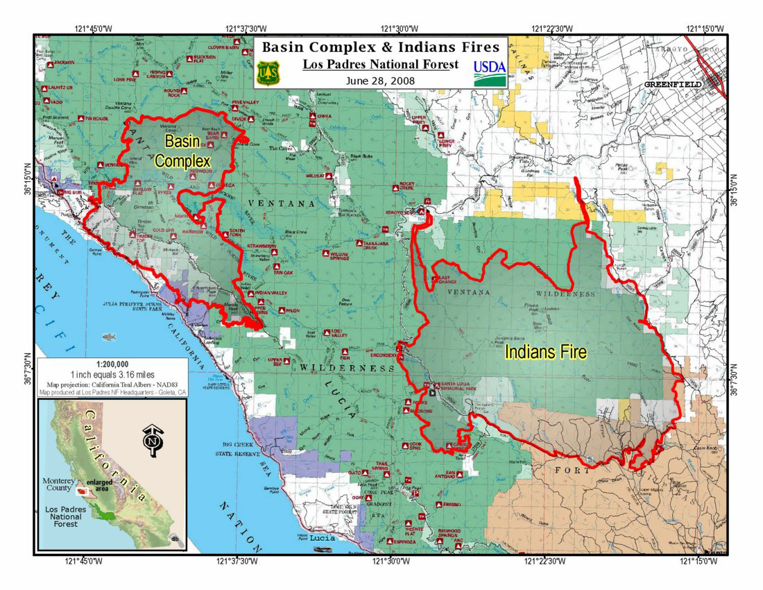
Click on the map for a larger image (700 KB).
Mothball the Rolling Stock
guest post by bear bait.
Wander around the Great Basin enough, and you know if you see a bunch of magpies something is dead below them. Tattle tales. See a bunch of birds in the air and on the water off Newport, and you know that salmon or some other predator have driven some bait to the surface.
Tattle tales.
So for the second time this week that I have seen, a whole train of empty longitudinal bulkhead railcars, “A” frames, has gone north by my house. I see very few of them going south with lumber. Just Weyerhaeuser Dallas and Hampton Willamina wood. And the two of them don’t use that many cars a month, let alone a week or day. Those cars are going to some track, somewhere, to be stored. My guess would be the eastern end of the flood destroyed RR to Tillamook. Maybe Hampton has a reload they are hauling to from Tillamook. But the wood is not going south on this road. Maybe to Portland and east, since the UP and the SP are now one and the same, the larger UP…
Jack and I have seen for better than a year, those A frames get stored by Drummond in Montana. If I remember right, using the Excessive’s speedometer and some dead reckoning, I figured that there was close to 6 miles of A frames stored on the empty track around Drummond on the old line that once went to Helena and the one that went south towards P-Burg.
The mothballed cars are a symptom of just how bad the lumber deal has gotten in the West. Every railcar needs its 60 to 80 feet of track, somewhere. Behind a locomotive team headed toward the market or mill those feet of track can be shared over time with other cars. In storage, though, nobody wins. Except that they will make clean scrap, and that’s close to $300 at ton…
On the scrap note, the Stettler linear mechanic said he has replaced, so far this spring, over $150,000 worth of copper wire stolen and stripped from linear and pivot irrigation systems. He dreads getting up in the morning because he knows he is going to get another call. He has figured out an alarm system, and is now installing them. I asked if there was a way to… and he said no… he can’t… there is a way but a coroner’s investigation would surely find the trap.
I cost accounted all my fertilizer into the predicted yield, and it comes out to about 3 cents a pound. That is not a place to pinch pennies at this time. We have a $1.25 floor price. It is 2 1/2 percent of the gross yield in cost. And I am including the new tank and pumps in all that. If I get 3% more fruit injecting instead of slopping it on dry, I will get out of a trip across the fields, and put the $2500 worth of fertilizer against the liquid used for injection… close to a push, in many ways. And a whole lot easier on the watershed and the plants, the wildlife, you name it.
I watched the whole CWS game last night. A good game for west coasters. A great game by the pitcher for Fresno State. Big ole chubby kid with a real easy delivery. And he threw strikes. Gave up one run, a homer, to the kid who set the season record for homers with the one last night. In a losing cause, though. Fresno State beat Georgia 6-1, and the 89th ranked team wins it all. Once again a West Coast team. Gotta take my hat off to those kids. Their hitter has a hanging thumb… no ligament… has to have a surgeon take a ligament out of his arm to rebuild it this summer. He went 4 for 4 at the plate. Drove in all 6 runs. Two home runs, a double and a single. Just a great effort. College baseball is more fun than the pros…
A cloudy, cool morning. And a heat wave coming, allegedly. Hope no fires. All the firefighters are in California. A thousand fires at one time does that to resources. Of course, all the answers are in the Natl Geographic July issue. It is all about too much fuel because fires have been fought. One little word about logging. It is all about WFU. Let It Burn. We are spending more to fight the fire than the land is worth. Of course, while I write this, a WFU in the Sierras called the Clover fire is now threatening homes… hmm. I thought the fire was supposed to stay in the wilderness and do Mother Nature’s good work. Silly me. The national intent, as it now stands, is to burn it all
instead of log any. Vunderbar!!!!
So we don’t drill for oil while Brazil goes out in the Atlantic and finds an estimated 90 billion barrels. Illegal to drill here in the US on either coast, especially where the Cubans and Russians are directional drilling into our seabed. Nothing new in Alaska, although that is where the oil is known to be in known amounts and most likely more to be discovered. No use of oil shale. That’s illegal, too. And Newt says speculation can be dealth with quite easily: dump the US reserves into the market all at once, and the longs positions get hammered, their money lost on the margin calls, and then take out the shorts as the market dumps. That would end the speculation. This oil deal is nothing more or nothing less than the same deal that Enron was doing with California electricity, except this is an offshore deal that only a government can take down by overloading the supply.
Time to go see what has broken since last night. ta ta, bear bait.
Legitimate and Needed
SOS Forests posts may be sparse for the next few days, due to time commitment to the CA fire situation at W.I.S.E. Fire Tracking [here]. We planned last Fall to track fires (it seemed a useful and reasonable thing to do), but we did not expect 900 in one day.
The CA fire situation will worsen over the next two weeks. Many fires are unstaffed and many engaged fires are growing rapidly despite firefighter efforts. Firefighting resources are stretched beyond thin and personnel are already experiencing fatigue from long shifts.
Fire reporting on the usual sites has also become threadbare, and some sites (InciWeb) are not working at all. Right now W.I.S.E. Fire Tracking may be the most comprehensive and up-to-date site out there. Visitor counts have expanded 10-fold, and we feel an obligation to continue our efforts to provide the best information that we can.
But for some insightful filler, here are comments from SOSF stalwart and forest scientist Dr. Bob Zybach. Ph.D. that appeared in this AM’s Oregonian:
To the editor:
The long-standing federal funding crisis in Oregon’s rural counties is starting to affect urban schools and now our governor and statewide news media are beginning to pay attention.
Gov. Ted Kulongoski said, “This isn’t just about rural Oregon. The ripple effects of this loss will extend to every K-12 student in the state” (”$238 million crisis hits Oregon,” June 24).
The real problem in rural Oregon is not about extending federal welfare payments another year or so to keep county governments and services afloat. It is, and has been for more than a decade, about jobs — real jobs that produce tax revenue, not government jobs that depend upon them.
Oregon has more than a million acres of dead and rotting trees going to waste on our federal lands. They are mute testimony to failed efforts to “save” our old growth.
The loss of legitimate and needed logging, trucking, and sawmilling jobs in our rural communities has destroyed the culture and economies of these towns and families, perhaps irreparably. A return to scientific management of our federal lands will cure all of the self-inflicted hardships the governor is complaining about.
BOB ZYBACH Springfield
CA Fires Tuesday Update
Last weekend a dry lightning storm ignited between 850 and 920 fires across California. The latest map of northern CA fires is [here]. The situation is confusing but here are the latest updates extracted from some of the fire reporting sites. From north to south:
Siskiyou Co. — Siskiyou Complex Fires in Dillon Creek near Happy Camp is pushing 1,000 acres. A Type 2 IMT has been called in. At last report 146 personnel and 0% containment. Multiple starts, many unstaffed.
- Mad Complex Fires on the Orleans RD, Siskiyou NF, Klamath River area, is also 1,000+ acres, multiple starts, many unstaffed.
- SRF Lightning Complex Fires, Klamath NF, Shasta-Trinity NF, Salmon River area, is also 1,000+ acres, multiple starts, many unstaffed. Fires include the Travis, Blue, Jake Allgood, Sims and Packsaddle Fires. Trinity Alps Wilderness may or may not be closed.
Trinity Co. — Iron Complex Fires, Shasta-Trinity NF, Weaverville area is reporting 36 fires, 9 contained, and 4 staffed, partially contained. The community of Junction City is threatened.
- Lime Complex Fires, Shasta-Trinity NF, Hayfork area is 6,400 acres, multiple starts, many unstaffed. The communities of Hayfork and Hyampom are threatened.
Shasta Co. — Whiskeytown Complex Fires, 8 miles west of Redding, 700 acres, 0% contained at last report. Fire 5-2 reached Shasta Bally road which has been closed due to fire activity. Boulder Creek Falls Trail remains closed due to Fire 5-3.
- SHU Lightning Complex Fires, east of Redding. Over 153 fires have been reported in the Shasta-Trinty Co. areas, at least 25 unstaffed. Shingletown fire at 455 acres with evacuations in place. Donkey fire at 360 acres with potential evacuations for Oak Run and Round Mountain. Democrat fire at 360 acres with structures threatened in the communities of Shasta and Keswick. Kirkman fire at 1500 acres. Pine fire at 750 acres with likely impact to HWY 299 East within 12 hours. Venture fire, East of Burney, at 1000 acres, structures threatened, evacuations in place, power transmission lines threatened and HWY 299 closed in the area.
Humboldt Co. — HUU Lightning Complex Fires, at least 50 fires. The Lone Pine Fire is 80 acres, the Paradise Fire NE of Shelter Cove is 500 acres and growing. The Redcrest Fire is 30 acres, the High Fire is in Humboldt Redwood State Park with unknown acreage or containment, the Carson Fire is 40 acres and 50% contained, the Hansen Fire is 2 acres with unknown containment, the Williams Fire is 25 acres and 50% contained, at last report.
Lassen Co. — 45 total fires reported. The Popcorn Fire east of Burney is 2,500 acres at last report. Little Valley is under a precautionary evacuation.
Tehema Co. — TGU Lightning Complex Fires. Over 37 fires for a total of 3,146 acres. 35 fires are contained. The Antelope Fire is 900 acres and 10% contained, the Mill Creek Fire is 900 acres with no containment.
Plumas Co. — Cub Complex Fires SW of Chester, Cub Fire is 800 acres, Onion Fire is 500 acres. As of 7 pm yesterday 309 personnel, 0% containment.
Sierra Co. — Canyon Complex Fires, more than 45 fires have been detected, many in the Feather River canyon. Several fires are aggressively backing into the middle fork and the north fork of the Feather River and Nelson Creek. Tree Ranger District affected. Includes the Hartman Fire and the Crest Fire. The Cold Fire is approx. 3,000 acres. Precautionary evacuation of animals in the communities of Spring Garden, Greenhorn, and Sloat (near Quincy) is in effect. Hwy 70 is closed from 1.5 miles East of Pulga in Butte Co. to Gansner Bar.
Mendocino Co. — Approx. 131 fires have been reported, burning more than 8,900 acres. Incident Command Team #4 has been assigned to this complex. The Orr Fire is 200 acres and has evacuations of the Orr Springs Resort and 50 homes in the area, the Navarro Fire is 1,400 acres and 5% contained, the Cherry fire is 50 acres and 50% contained, the Foster Fire is 50 acres and 50% contained, the Table Mtn. Fire is 1,000 acres and 5% contained, the Mallo Pass Fire is 800 acres, and the Juan Creek fires (2) are at 100 acres each. There are 8 additional fires at 30 acres each.
There is a voluntary evacuation recommended and issued by the Anderson Valley Fire Department for the following areas: Rancho Navarro, Nash Mill Road from Clough Ridge to the top of Nash Mill Subdivision, Mountain View Rd. near mile marker 17 in the vicinity of Hanes Ranch, Easterly portion of Signal Ridge Rd. in the vicinity of Rossi Ranch below Cold Springs Lookout. The Anderson Valley Fire Department advises that they may not be able to put out a mandatory evacuation and individuals should monitor the fires and be prepared to decide to evacuate on their own; individuals who cannot do a fire watch through the night are advised to voluntarily evacuate.
There is a precautionary evacuation issued by Cal Fire on Mountain View Road at Mile Post 9 East of Manchester.
KZYX, Mendocino Public Broadcast Radio [here] has good information.
Lake Co. — June ABCD Complex Fires, W of Willows. 49 fires reported. Walker Fire, Indian Valley Reservoir, 8,600 acres, 5% contained.
Butte Co. — N of Paradise. 25 fires for a total of more than 3,900 acres, 8 fires are contained. The Rim Fire has burned 50 acres with unknown containment. Butte County Sheriff’s department is affecting a Precautionary Evacuation Advisory for the Lake Concow Area for a lighting fire in excess of 100 acres burning off of Rim Rd. (Also referred to as Andy Mountain Rd.) in the Concow area. The American Red Cross is setting up an evacuation shelter at the Spring Valley School at 2771 Pentz Rd. off of Hwy 70. There are four road closures in effect: Concow Rd. from Yellow Wood Rd. north to the end of the pavement on Concow Rd, Concow Rd. from Nelson Bar to end of pavement, Rim Rd. (also known as Andy Mtn. Rd) from Hwy 70 to end of Rim Rd., Deadwood from Hwy 70 to Concow Rd. June 24, 2008 11:10 am
Nevada Co. — Yuba River Complex Fires, 34 fires reported. Scotchman Fire 500 acres near Washington. Fall Fire, 1,100 acres and spreading to the N along Bowman Lake Road. Hydro-electric facilities and lines are threatened. 25 Fire, Celina Fire, Foresthill (formerly Mosquito) Fire which is 75 acres and 90% contained.
Placer Co. — American River Complex Fires: Peavine Fire, 20 acres, Middle Fork American River sub-drainage; Gov Fire, 100 acres, within Wild and Scenic River area, Westville Fire, 25 acres, North Fork American River.
Napa Co. — Wild Fire, 4,089 acres, 80% contained.
Santa Clara Co. - 15 fires have been contained, burning more than 964 acres. Whitehurst/Hummingbird Fires 100% contained.
Amador Co. — All fires for a total of 80 acres have been contained.
Tolumne Co. — 9 fires for a total of 5,720 acres. All fires reported contained, except North Mountain Fire, 550 acres, 0%, 7 mi NE of Groveland.
Madera, Mariposa, Merced Cos. — 40 fires reported. Oliver Complex Fires, 200 acres, 5% contained. The Cunningham Complex, 3,150 acres, Indian Peak Fire, 60 acres. Mariposa Complex Fires are 100% contained at 2500 acres. Sierra NF reported 25 of the 40 fires; 14 are still active.
Monterey Co. — Indians Fire 58,000 acres, Los Padres NF, burning since June 8th, 66% contained, costs to date over $30 million. Basin Complex Fires 5 mi S of Big Sur, lightning-ignited June 21, 7,025 acres, 3% contained. Landslide on Hwy 1 south of the fires has closed the Hwy, Caltrans is monitoring, unsafe to take action to mitigate. Mandatory evacuations from Ventana Inn south to Julia Pfeiffer Day Use Area. Brown Fire, Hollister, 3870 acres, 100% contained.
Tulare, Inyo Cos. — Clover Fire, 13,050 acres. The Clover Fire is a Let It Burn Fire that blew up Sunday from 4,000 acres, crossed the Sierra crest, and has burned nearly to Hwy 395. Over $2 million were been spent watching this fire since it started May 31st. Now many more millions must be spent to contain it, and fire suppression resources must be drawn away from critical need areas in the rest of the state. The Sequoia NF is responsible for this fiasco.
Clover Fire Blows Up
The Clover WFU-not-a-WFU Fire blew up yesterday, has more than tripled in size, has crested the Sierras, and is threatening Hwy 395 north of Coso Junction.
All this on a day when much of California is on fire from dry lightning storms of last weekend. The strain on fire suppression capability is enormous, a true national state of emergency, and the Clover Fire has been burning for nearly a month while the USFS watched it like dumb oxen.
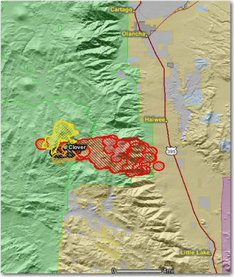
Map courtesy Bill Gabbert, Wildfire Today [here].
More from Wildfire Today:
As we reported yesterday, the Clover fire on the Sequoia National Forest in California, formerly a fire use fire, is now being suppressed. The problem is, it got up and ran yesterday…. big time.
I wonder if the bean counter regrets their decision to release some of the hot shot crews after working only 10 days so they would not have to pay overtime associated with mandatory days off with pay after working the normal 14 days on an assignment? They had planned to re-order the crews in a few days. Now with 911 new fires in the state all competing for resources, they will be lucky to get any orders filled.
The new policy of having U.S. Forest Service bean counters making strategic decisions like this could result in more Clover fires. Fires that actually cost much more than they would otherwise, while burning private land and putting citizens at a greater risk. This is the new “Accountable Cost Management” process. Who is going to be accountable for the Clover fire decisions?
I’ll tell you who ought to held accountable: Gail Kimbell and the Wildland Fire Leadership Council. They got in bed with radical enviro-arsonists and now the chickens have come home to roost. They just love to whoofoo. Gotta have their whoofoo. They think whoofoo is the best thing since sliced bread. They whoofoo with ZERO authority from Congress, completely outside the law, and with criminal impunity.
Maybe if we appointed actual foresters, who actually cared about forests to our local and national forestry leadership positions, instead of Shining Path Maoist insurgent wackbite crazy arsonist loonies, we might do a better job of protecting natural resources and rural communities.
Putting anti-American com-symp eco-terrorists in positions of power is the death knell for this country. People need to wake up and smell the coffee. Howdy Doody Che puppets at the wheel with Burn Baby Burn mentalities are not good for forests, our way of life, or our very lives, for that matter.
Those nutjobs want a revolution? Well, maybe they ought to get one. If something has to burn, better them than us.
Salmon River whoofoo from 2007, pic #1752. See comments below.
Grand Canyon Forest Holocaust Suspended
The brain trust at Grand Canyon NP decided to suspend the Walla Valley Prescribed Burn this morning after torching off a small portion last night. Their intention was to “mimic” a natural fire [here]:
In an effort to simulate natural fire events in the north rim forests, the Walla Valley prescribed burn will use a point source ignition technique intended to mimic receiving a group of lightning ignitions. These ignition points will be allowed to burn in all directions in the same way a naturally ignited fire would burn. The fire is expected to burn over a period of at least 3 weeks, exposing it to a variety of weather and wind conditions. As a result, it is expected that the effects of the Walla Valley prescribed burn will more closely resemble a natural fire then the effects seen on most conventional prescribed burns.
but when the match was struck they had second thoughts. From today’s GCNP press release [here]:
Fire Managers at Grand Canyon National Park Suspend Ignition of Walla Valley Prescribed Burn
Grand Canyon, AZ. – Early in the morning on Sunday, June 22, fire management officials on the North Rim of Grand Canyon National Park made the decision to suspend ignition of the Walla Valley Prescribed Burn. At this time, no further ignition activities will occur unless there is a change in the weather and fuel conditions that effect fire behavior.
Ignition operations on the Walla Valley Prescribed Burn began at approximately, 6:20 p.m., on the evening of Saturday, June 21. After assessing the behavior of a small test fire and finding it to be within acceptable parameters, fire crews began the burn by blacklining along the eastern flank of the burn unit in order to fully secure the perimeter of the fire. Once that perimeter was secure, a point source ignition technique would then be used within the burn unit in an effort to mimic the effects of summer lightning strikes. During this blacklining operation, spot fires began to occur and at greater distances than anticipated from the blackline and were immediately suppressed.
The “simulated natural fire” proponents were overruled by the firefighters. It was a completely stupid idea in the first place, as we so gently pointed out [here]. Apparently wiser heads prevailed, those heads being the ones on the shoulders of the people who were supposed to control the fire. The theoretical “naturalists” were told to stuff it.
The Clover WFU Fire
Yesterday and the day before, dry lightning raked California. Over 400 fires were ignited [here], from the Shasta-Trinity National Forest south through Mendocino County and all the way to the Sequoia NF at the southern end of the Sierra Nevada. State and federal fire crews are scrambling to do initial attack on fires that are still being detected as I write.
Two fires have been burning for weeks, though. The Indians Fire in the Los Padres NF (Monterey Co.) [here] was ignited by an untended campfire on June 8th. It is now over 50,000 acres and 55 percent contained. Over 2,500 personnel are fighting the Indians Fire; nine firefighters have been injured to date. Two residences and 13 outbuildings have been destroyed. The residents of upper Pine Canyon have been evacuated since June 18th. Nearly $30 million has been spent on fire suppression. Three new fires were ignited in the Los Padres by the dry lightning, and crews from the Indians Fire are engaging in initial attack on those right now.
The Clover WFU Fire [here] has been burning in the Sequoia NF since May 31st. WFU stands for Wildland Fire Use, and is a synonym for Let It Burn. The leadership of the Sequoia NF has been letting the Clover WFU burn for nearly a month. In the last week the fire has nearly tripled in size from 1,600 acres to over 4,000 acres.
Despite the WFU designation, nearly $2 million have been spent “monitoring” the Clover WFU Fire. The Pacific Crest Trail has been closed and hikers rerouted. Some suppression efforts have been implemented at the southern end of the fire north of Kennedy Meadows, but as of yesterday all that changed. The WFU designation is still in place but the monitoring crew has been “demobilized” and a Type 2 Incident Management Team ordered in. Personnel count on the fire has jumped from about 80 to nearly 300 firefighters and support teams.
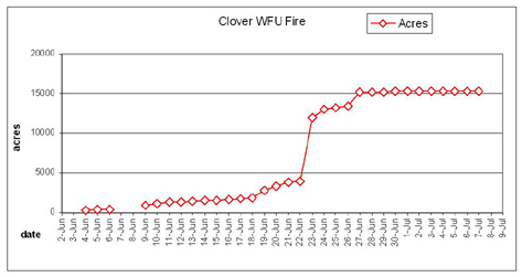
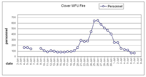
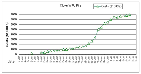
The Clover WFU Fire is pulling resources away from critical need areas. This fire could have been suppressed in early June at less than 100 acres and less than $100,000. Instead $2 million have been spent, 4,000 acres have burned, and the rest of the state has been placed at reduced readiness for fires that are occurring elsewhere today.
The Sequoia National Forest alone has reported 25 fires from lightning storms of yesterday.
A New Wyden Forest Bill
Oregon Senator Ron Wyden announced today that he is preparing a new forest management bill to address federal forest management in Oregon. Wyden is seeking public comment on his proposal, called the Oregon Forest Restoration and Old Growth Protection Act.
The proposed bill is [here], a summary of the bill is [here], Wyden’s Senate floor statement is [here], and a press release is [here]. Comments on the proposed bill may be emailed to Wyden [here].
In January Oregon Congressman Peter DeFazio introduced legislation he called the Pacific Northwest Forest Legacy Act [here]. In February Jeff Bingaman (D-NM) introduced S. 2593, the Forest Landscape Restoration Act of 2008 [here] which was co-sponsored by Sen. Wyden. Both bills dealt with federal forests in Oregon; neither has moved beyond preliminary hearings.
The Wyden bill is similar to the DeFazio bill with some elements of the Bingaman bill. We will provide a more in-depth analysis soon.
From Wyden’s press release:
Striking a balance between the need to sustain forests, as well as bolster the economy, U.S. Senator Ron Wyden (D-Ore.) today proposed an expansive overhaul of federal forest practices in the State of Oregon. Wyden’s initiative would permanently end the logging of old growth trees and discourage clear-cutting, while placing a new emphasis on greatly expedited, large-scale forest restoration efforts to improve forest health and create many thousands of new jobs.
“For the sake of our environment, economy, and our way of life, we must come together to pursue a concerted, new focus on sustainable forestry management that will create thousands of new jobs and restore the health of our forests,” Wyden said. “The only way to produce this kind of change is to put new ideas forward, seek common ground, and break away from the old politics that led us to this dysfunctional and dangerous situation.”
Decades of scientifically-unsound forest management and fire suppression policies have put millions of acres of choked and plantation forests at an unacceptably high risk for uncharacteristically-severe fires, disease, and insect infestation. Wyden’s proposal, the “Oregon Forest Restoration and Old Growth Protection Act,” would address this emergency by:
- requiring the U.S. Forest Service and Bureau of Land Management (BLM) in Oregon to re-direct their management activities to address fire and insect risk, while protecting environmentally-sensitive and significant lands, and promote ongoing, sustainable production of wood;
- eliminating administrative appeals for forest management conducted under the new forestry directives;
- allowing pilot restoration projects of up to 25,000 acres in each of Oregon’s national forests and BLM districts in at-risk areas without encountering years of NEPA and administrative delay (by issuing those projects a “Categorical Exclusion” from NEPA review).
As we have seen in the past with the Healthy Forests Restoration Act (2003), the elimination of administrative appeals and categorical exclusion from NEPA (National Environmental Policy Act) have been rejected by federal courts time and time again. There is no reason to believe that the Wyden bill will have any success in that regard. If Congress finds NEPA to be unworkable, then they should revise or rescind it. Otherwise, they should abide by it. This appears to be a fatal flaw in Wyden’s bill at this time.
2007 Fire Season Federal forest policy Politics and politicians The 2008 Fire Season
by admin
1 comment
Casey At the Bat on Fire
Casey Judd, Business Manager of the Federal Wildland Fire Service Association, gave hard hitting testimony to the Senate Committee on Energy and Natural Resources yesterday. He told them that our federal land management agencies and their fire programs are ill-prepared for the upcoming wildfire season.
Judd discussed three causes: the mass migration of federal wildland firefighters to CAL FIRE and other fire agencies offering better pay, benefits, and working conditions; the diversion of fire preparedness resources to pay for a variety of non-fire programs, positions and projects; and a paucity of hazardous fuel reduction projects.
The full text of Casey Judd’s testimony is [here]. Some excerpts:
This and other committees have been consistently told by the Agencies and “experts” that suppression costs are continuing to rise because of 1) climate/drought and 2) the increasing costs of protecting the Wildland Urban Interface. We, the FWFSA, take serious note with these assumptions. While these two elements are indeed factors, proper preparedness mitigates to a great degree the influence these two elements have on the overall costs of suppression. The question has been posed by both Congress and OMB: If it stands to reason that proper preparedness lead to reduced suppression costs, why after increased preparedness funding under the National Fire Plan, have suppression costs continued to rise? A simple answer – Smoke and Mirrors. …
In February 2006, Agency (USDA) representatives appeared before this committee and once again assured the Committee that adequate preparedness resources would be in place. Firefighters knew this wasn’t going to be the case. The continuation of diverting preparedness dollars resulted in less preparedness resources in the field. The diversion of fuels reduction dollars reduced the number of treated acres. The result was what firefighters expected: reduced preparedness resources allowed many small fires to grow in size, intensity and ultimately cost as either Incident Commanders waited for federal resources that had to now come from much greater distances or, in the typical alternative, the Agency reverted to its over-reliance on significantly higher-priced non-federal resources to fill in the gaps of the missing federal resources. Either way suppression costs increased needlessly. The result was a record year for suppression costs.
Rather than admitting the diversion of funds played a role in less resources being in place and thus ultimately increasing the costs of fires needlessly, the Agency simply reverted to its theory of climate and wildland urban interface as the causes of increased suppression costs.
In 2007 we suggested to Congress that a repeat of 2006 was inevitable. We further predicted as we correctly did in 2006 that the Agency would return to Congress in the fall, complain that it had been a terrible season and seek a supplemental appropriation of another half billion dollars. That is exactly what happened. …
As we enter the 2008 season, the Forest Service fire program, primarily focused in the western United States, and especially in California is imploding. …
Grand Canyon Forest Holocaust Planned
The Grand Canyon National Park is planning to deliberately set fire to the North Rim forests in a grand experiment known as the Walla Valley Prescribed Fire. This experimental holocaust has been subject to zero, nada, the empty set NEPA process. There has been no EIS written, no public involvement, and not the slightest gesture towards compliance with the environmental laws of the United States of America.
From the GCNP Press Release of June 16th [here]:
Grand Canyon, Ariz. - A prescribed fire is scheduled to take place on the North Rim of Grand Canyon National Park in the next several days if conditions allow. The 6,200-acre Walla Valley prescribed burn unit is located in the Walla Valley and Point Sublime area, approximately 5 miles west of the North Rim developed area.
In an effort to simulate natural fire events in the north rim forests, the Walla Valley prescribed burn will use a point source ignition technique intended to mimic receiving a group of lightning ignitions. These ignition points will be allowed to burn in all directions in the same way a naturally ignited fire would burn. The fire is expected to burn over a period of at least 3 weeks, exposing it to a variety of weather and wind conditions. As a result, it is expected that the effects of the Walla Valley prescribed burn will more closely resemble a natural fire then the effects seen on most conventional prescribed burns.
The spit-on-the-law criminal elements responsible include Maureen Oltrogge, Shanna Marcak, Robert Dauphinais, Assistant Supervisor, and Steve Martin, Superintendent, Grand Canyon.
The National Park Service is infamous for horrendous forest fires that do extreme damage and cost $billions. In 1988 the NPS burned up nearly half of Yellowstone N.P., the original and most treasured of all our national parks. In 2000 the NPS deliberately set fire to Bandelier National Monument, and their fire escaped. The Cerro Grande Fire burned up half of Los Alamos and left a bill of over a billion dollars in the taxpayer’s lap.
In 2000 the NPS deliberately set fire to the Grand Canyon NP North Rim forest in a mistake called the Outlet Fire. That fire also forced evacuation of the Park. In 2007 their sister agency, the Kaibab NF, deliberately burned 58,000 acres of old-growth spotted owl habitat adjacent to the North Rim, in utter defiance of a Federal court order commanding them not to do that. (For reference, see Back to the Rim [here]).
But learning from past mistakes is not their style. Repeating them is.
So once again an incompetent crew of headstrong, middle-finger waving government functionaries are going to roast the holy hell out of the North Rim. The Walla Valley Prescribed Fire will cost $millions (money that has NOT been allocated by Congress for the purpose), do extreme damage to heritage forests, historical sites, wildlife habitat, scenery, and tourism in a National Park, probably escape the pathetic “controls” planned by the pathetic GCNP fire team, possibly kill firefighters, assuredly kill endangered species, and all be done illegally, with no NEPA, no EIS, no ESA Section 7 consultations, no NHPA Section 6 consultations, etc.
Just wild and crazy government-employed eco-terrorists hellbent on burning a National Park to ashes.
Business as usual in Amerika. Burn baby burn.
The Bear Creek Guard Station
From Al Stangenberger, College of Natural Resources, U.C. Berkeley:
The photos are of the old Bear Creek Guard Station, which is just over the hills to the south of Summer Camp [The UC Forestry Summer Camp is in Meadow Valley, west of Quincy, CA]. Bear Creek drains into the Middle Fork of the Feather River.
The station was built in the early days of the USFS when rangers patrolled on horseback. It was a really nice spot. Rudy Grah took me up to see it a year or so before he died.
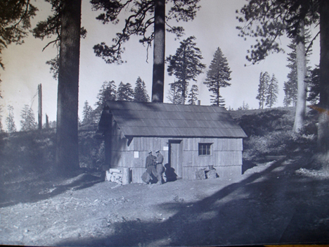
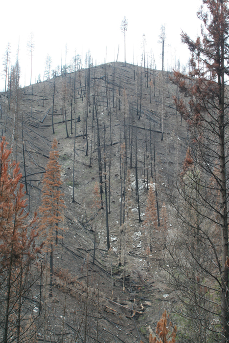
The Bear Creek Guard Station in 1915, built with hand-split ponderosa pine shakes. Note the open, park-like forest. The forest structure was the result of many hundreds of years of regular, seasonal, anthropogenic (Maidu Indian) fires.
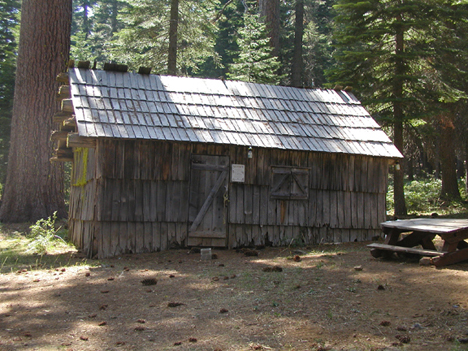
The Bear Creek Guard Station in 2005. Note the invasion of the older forest by a thicket of younger cohort pine, Douglas-fir, and white fir, the result of 90 years without forest stewardship or Indian fires.
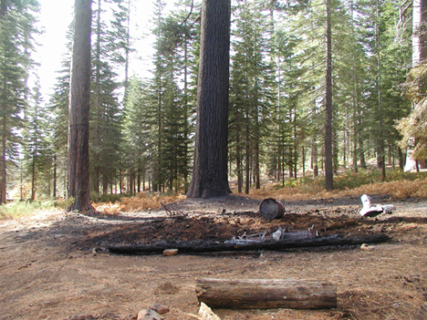
A careless guest used the stove and didn’t do it correctly.
Al writes:
Too bad, it was a really nice artifact. The stable building still survives.
For many of us, a tragic loss and poignant memories of Summer Camp, Rudy Grah, and the Plumas NF.
And for many others, perhaps, a lesson in history and forest development pathways. Without stewardship, ancient treasures will be lost.
Thank you for the memories and the lesson, Al.
The Real Indiana Jones
As Harrison Ford reprises (again) his Hollywood role as an academic turned adventurer, few people know that the character he plays, Indiana Jones, had a real life counterpart, or so was self-proclaimed by the Peruvian explorer and raconteur Gene Savoy [here].
However, I wish to offer another candidate, who in my opinion fits the legendary description much better. In this Indiana Jones’ own words:
It was 1956. I had just finished my first year of graduate school at Berkeley, with hopes of becoming a desert geographer. …
Alas, academic standards in graduate school were much higher than I expected. My first year was a disaster and after floundering around I dropped out. That June, my high school buddy Ray H. and I got jobs as unpaid deckhands aboard the S.S. Hardanger. It was a Norwegian freighter heading south out of Los Angeles down along the coast of Mexico and South America, rounding the horn and up the coast of Brazil …
I didn’t make it all the way. I jumped ship in Lima where I knew Don W. from Long Beach. .. I only had a few hundred dollars and was happy when Don helped me land a job with the the city’s English language weekly newspaper, The Peruvian Times.
So begins the saga of the fellow who went on to discover a lost civilization and later helped rewrite the academic discipline of ancient landscape geography.
His name is Bill Denevan, Dr. William M. Denevan Ph.D., professor emeritus and former Chair of the Dept. of Geography at the University of Wisconsin-Madison.
Some fifty years ago, on one his forays into the uncharted Amazon basin, he flew over the Bolivian swamps of the Rio Beni in a transport plane. Below him spread the Beni savanna for thousands of square miles, the Llanos de Mojos, an immense grassland frequently flooded for half the year. In those days the Llanos de Mojos were occupied mainly by a handful of Indians and cowboys, who scrabbled for a meager living with slash-and-burn gardens and half-wild cattle in the pampas, palm thickets, and scrub lands.
I talked my way onto a B-17 bomber left over from World War II. With several others, it was used to haul beef from the Beni savanna to Cochabamba and La Paz. I rode in a side gun turret surrounded by raw meat—scary, but I had a great view of the seasonally flooded Llanos de Mojos. Looking down I could make out some strange linear features, which as a landscape geographer I knew were neither natural nor modern. They turned out to be prehistoric causeways, canals, and raised fields. I didn’t realize then that just five years later I would be down in those swamps gathering information for my doctoral dissertation.
The above quotes are from The South American Explorer, No. 78, Spring 2005, a retrospective Bill wrote entitled “In Amazonia for the Peruvian Times.” Bill Denevan does not claim to be the real Indiana Jones, although, he says, “I might have met him,” speaking of Savoy. To tell the truth, he is somewhat dismayed by the nomination. But only a few have uncovered (rediscovered) more about the lost civilizations of Amazonia than Bill.
Bill Denevan went on to become a real scholar, too, something the Hollywood Indiana Jones only hints at. His greatest scholarly work is probably Cultivated Landscapes of Native Amazonia and the Andes (2001, Oxford Univ. Press), widely recognized as the modern masterpiece of historical landscape geography. It is one of a trilogy of books inspired and coordinated by Denevan. The others are Cultivated Landscapes of Native North America by William Doolittle and Cultivated Landscapes of Middle America on the Eve of Conquest by Thomas M. Whitmore and B.L. Turner II.
Note: we intend to review all three of these books in the W.I.S.E. History of Western Landscapes Colloquium. Most recently we posted excerpts from Bill Denevan’s seminal essay, The Pristine Myth: The Landscape of the Americas in 1492 [here].
more »
Oxygen Isotopes in Tree Rings a Poor Yardstick of Climate Change
For many years certain paleobotanists have claimed that the oxygen isotope ratios in tree rings are indicators of the temperature during the growing season that the ring developed. They have used the O isotope ratio to “reconstruct” past climates as evidence of climate change.
Now it turns out that theory is highly questionable. New findings, to be published in an upcoming issue of Nature, indicate that tree leaves photosynthesize at a constant temperature. From ScienceNews [here]:
Goldilocks tree leaves
By Susan Milius, ScienceNews, June 11th, 2008
Sweating in the heat or huddling in the cold keeps temperatures favorable
Tree leaves do a pretty good job of achieving temperatures that are just right for photosynthesis, even if it’s too hot or too cold where they live, a new study shows.
From roughly the top to the bottom of North America, across some 50 degrees of latitude, trees all do their photosynthesizing at leaf temperatures around 21.4° Celsius plus or minus 2.2 degrees, says physiological ecologist Brent Helliker of the University of Pennsylvania in Philadelphia. That conclusion was based on a broad survey of the ratios of two forms of oxygen that vary depending on the temperature and humidity of leaves. Those properties control evaporation and make a signature in the cellulose of the tree rings, Helliker and colleague Suzanna Richter report in an upcoming Nature.
Such temperature control undermines the assumption that the insides of leaves have the same temperature as the air, Helliker says. That’s an assumption underlying studies that check oxygen ratios in old tree tissue to reconstruct past climates, he says.
The tree-ring community is just starting to sort out what the finding means. “I, and I am sure my colleagues in isotope dendroclimatology, will welcome this paper because it improves our understanding of the complex relationship between climate and the stable isotope ratios in wood,” says Danny McCarroll of the University of Wales Swansea. However, he objects to Helliker’s claim that paleoclimatologists’ approaches have relied so heavily on whether leaf temperatures match those of the surrounding air.
Dust Devils
We invite you (strongly urge you) to read Dust Devils: Cynical Politics Is the Hot Wind that Powers Environmental Radicals by Tim Findley, published in RANGE Magazine, Summer 2008 [here] (264KB pdf file — requires Adobe Reader 8.0 available here).
Range Magazine is the premier periodical of the West today. In their own words:
RANGE Magazine is an award-winning publication devoted to the issues that threaten the West, its people, lifestyles, lands and wildlife. Known for its powerful photos and straight talk, RANGE exposes a land and lifestyle in crisis and shows how daily challenges are being met with grit, determination and humor. No stranger to controversy, RANGE is the leading forum for divergent viewpoints in the search for solutions that will halt the depletion of a national resource, the American cowboy.
While RANGE Magazine is a subscription periodical, Editor C.J. Hadley generously posts a few articles from each issue on their website. Dust Devils is one of those articles made available to non-subscribers. Author Tim Findley is the top journalist at RANGE, and one on the most important contemporary voices discussing rural issues in the country. His latest essay is a retrospective about how we got into the environmental mess we are in today.
In Dust Devils Findley relates the interwoven machinations of Bill Clinton, Al Gore, Bruce Babbitt, Dave Foreman, the Nature Conservancy, and many others, and how their radical politics have threatened and engendered catastrophe for residents of the American West over the last twenty years.
Findley highlights the 1.7 million acre land grab of the Grand Staircase-Escalante region in Utah, and connects the dots to the usurping of even vaster tracts of the West for putative “wilderness”; land grabs that have led to the catastrophic destruction, not protection or conservation, of millions upon millions of acres.
The destructive land grabbing continues to this day.
A small excerpt from Dust Devils by Tim Findley:
In a politically frozen government, resources of fuel, timber and minerals remain untouched by any new initiative. Future policy was still enclosed by the paradigm of shadows. In Utah, 12 years after the Escalante’s grab, and despite opposition from the state’s entire congressional delegation, the Southern Utah Wilderness Alliance has enlisted the support of New York politicians to produce legislation that would declare another nine million acres of Utah wilderness.
But that much is just an old familiar tune compared to more than 20 pieces of legislation for legacy-building wilderness that are coiled in congressional committees awaiting approval this year or next. They include the Northern Rockies Ecosystem Protection Act sponsored by a New York Congresswoman and 187 cosponsors. That act alone would designate more than 20 million acres across the spine of the nation as human-excluding wilderness.
Dreaming on their own, the U.S. Forest Service has on the table a conservation strategy to promote “wilderness values” on 400 million acres, including private land.
Taken together or even apart, the plans have their only equivalent in the Louisiana Purchase. It is not a myth; it is not even regarded in Washington as an outrage. But it is certainly audacious.
The long campaign leading to this November’s presidential election has given almost no attention at all to the West, except it has been seen as the most obvious victim of the swarm of illegal immigration, which, ironically, is the chief source of Foreman’s feared population growth. President Bush himself has made gestures to protect the border, but he has also not been clear about his secret talks with Canadian and Mexican heads of state that investigators say may lead to a sovereignty-surrendering North American Union. …
The devils fade away in the shadows of the night. Do we know what we may be sacrificing?