Indians Fire
Location: 20 mi W of Kings City, Monterey Co., CA
Specific Location: Escondido Campground area, Ventana Wilderness, Los Padres NF, W of Fort Hunter Liggett, along Indians-Arroyo Seco Rd., Lat 36° 6´ 3″; Lon 121° 25´ 9″
Date of Origin: 06/08/08
Cause: escaped campfire
Situation as of 07/06/08 6:00 PM
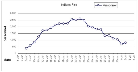
Total Personnel: 123
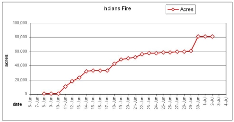
Size: 81,378 acres
Percent Contained: 97%
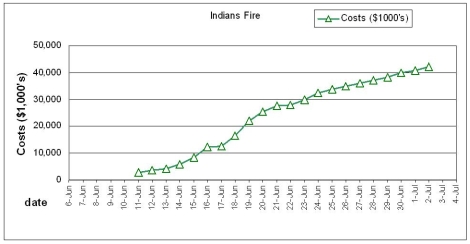
Cost to date: $42,200,000
Approximately 10000 acres of the Indians Fire total are interior islands that have not yet burned. Cost estimate reduced due to reassignment of resources adjustment.
***************
Situation as of 07/04/08 6:00 PM
Total Personnel: 606
Size: 81,378 acres
Percent Contained: 95%
Cost to date: $43.0 million
***************
Situation as of 07/03/08 6:00 AM
Total Personnel: 790
Size: 81,378 acres
Percent Contained: 95%
Cost to date: $42.8 million
Containment expected by July 7, 2008. Continued Voluntary Evacuation Recommendation remains in place for the Arroyo Seco Rd area. Isolated pockets of surface fire with single tree torching. Fire behavior moderated by higher humidity.
The Indians Fire continues to logistically support 340 personnel operating on the East Basin Complex.
***************
Situation as of 07/03/08 6:00 AM
Total Personnel: 811
Size: 81,378 acres
Percent Contained: 95%
Cost to date: $42.2 million
Containment expected by July 7, 2008.
***************
Situation as of 07/01/08 6:00 PM
Total Personnel: 703
Size: 81,378 acres
Percent Contained: 95%
Costs to Date: $40,900,000
Voluntary Evacuation Recommendation remains in place for the Arroyo Seco Rd area.
***************
Situation as of 06/29/08 6:00 PM
Total Personnel: 1,056
Size: 81,378 acres
Percent Contained: 95%
Costs to Date: $39,900,000
Evacuation Order for Arroyo Seco residents reduced to Voluntary Evacuation Recommendation at 1800 today. Firing operation for interior islands south of Arroyo Seco Rd successful.
There are approximately 20000 acres of interior islands that have not yet burned. The Indians Fire continues to logistically support 333 personnel operating on the East Basin Complex Fire.
***************
Situation as of 06/29/08 6:00 AM
Total Personnel: 1,125
Size: 60,845 acres
Percent Contained: 89%
Costs to Date: $38,400,000
Continued Evacuation Order for Arroyo Seco residents. Firing operation in that area still in progress. The spike camp continues to operate in the town of Greenfield. The Basin Complex is zoned creating an East Zone and West Zone managed by CIIMT2 and CIIMT5. The Indians Fire continues to logistically support 215 personnel operating in the East Zone of the Basin Complex.
***************
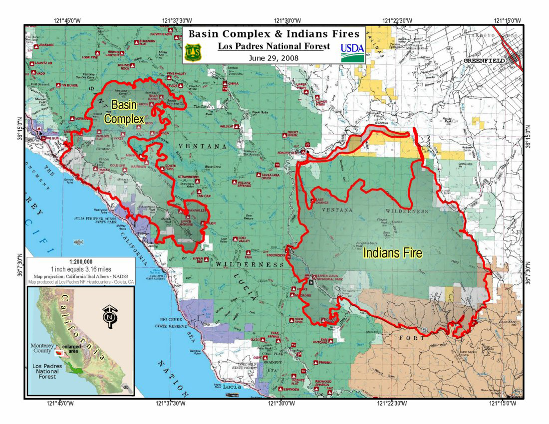
Combined Indians Fire/ Basin Fire map as of 06/29 — click on map for larger image
Situation as of 06/28/08 6:00 PM
Total Personnel: 1,338
Size: 60,074 acres
Percent Contained: 82%
Continued to provide structure protection in the Arroyo Seco drainage. Significant progress made with firing operations in the Arroyo Seco drainage with firing continuing into the night operational shift as weather permits.
Evacuation Order remains in effect for the residents of the Arroyo Seco drainage.
***************
Situation as of 06/27/08 6:00 PM
Total Personnel: 1,333
Size: 59,791 acres
Percent Contained: 71%
Costs to Date: $36,100,000
Evacuation Order remains in effect for the residents of the Arroyo Seco drainage. Significant progress made with firing operations on the north perimeter and will continue as weather conditions permit.
***************
Situation as of 06/26/08 8:00 PM
Total Personnel: 1,810
Size: 59,066 acres
Percent Contained: 71%
Costs to date: $34,900,000
Residences destroyed: 2 Outbuildings destroyed: 13
Firefighters injured to date: 14
A FIRE EVACUATION ADVISORY has been issued for residents of the following areas:
Carmel Valley Road (G16) from its intersection with Arroyo Seco Road to its intersection with Tassajara Road (5007); Tassajara Road from its intersection with Carmel Valley Road to the national forest boundary; Cachagua Road from Tassajara Road to the Nason Road turnoff.
An advisory is a precautionary notice and you should prepare for a possible future evacuation. Owners of livestock and large animals should consider gathering and transporting their animals now to minimize vehicle congestion along the roads should an evacuation become necessary.
Fire managers expect that there will be additional fire vehicle traffic along roads in the area as firefighters begin construction of contingency lines west of Carmel Valley Road north of Arroyo Seco Road.
Weather predictions indicate the possibility of SE winds accompanied by thunder storms with lightning over the weekend.
***************
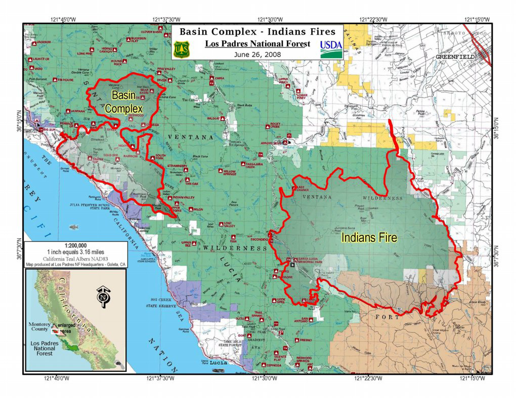
Combined Indians Fire/ Basin Fire map as of 06/26 — click on map for larger image
Situation as of 06/25/08 8:00 AM
Total Personnel: 1810
Size: 59,066 acres
Percent Contained: 71%
Costs to date: $35,000,000 (est.)
***************
Situation as of 06/25/08 8:00 AM
Total Personnel: 1956
Size: 57,943 acres
Percent Contained: 71%
Costs to date: $33,800,000
***************
Situation as of 06/23/08 9:00 PM
Total Personnel: 2,026
Size: 57,745 acres
Percent Contained: 66%
Costs to date: $29,900,000
A voluntary evacuation is in place for upper Pine Canyon and Arroyo Seco. An evacuation advisory is in place for lower Pine Canyon and Thompson Canyon. Reliz Canyon Road and upper Pine Canyon Road remain open to residents only.
Active fire behavior with single and group tree torching. Firing operations negatively impacted by smoke from the Basin Complex.
***************
Situation as of 06/22/08 6:00 PM
Total Personnel: 2,472
Size: 56,044 acres
Percent Contained: 57%
Costs to date: $28,000,000
A large animal advisory was issued today for Arroyo Seco Canyon Road and the west side of Reliz Canyon Road. Although no evacuations orders have been issued at this time, decision points have been established. If the fire reaches these points evacuations will be implemented. Due to extended travel times a spike camp has been established in the town Greenfield.
***************
Situation as of 06/21/08 8:00 PM
Total Personnel: 2,583
Size: 52,200 acres
Percent Contained: 55%
Costs to date: $27,600,000
Firefighters injured to date: 9
2 residences destroyed, 13 outbuildings destroyed. Structures threatened: 1,063 residences, 265 other
A thunder cell moved over the general area causing three new fires in the area west of the Indians Fire. The Gallery Fire is located on the Big Sur Coast just south of Grimes Point near Timber Top Camp. The Basin Fire and a third yet unnamed fire are within the Ventana Wilderness northwest of the Indians Fire. The Basin Fire is near Bear Basin Camp. A precise location of the third fire has not been established. Some resources, including aircraft, engines and crews were utilized from the Indians Fire to aid in the initial attack on these new fires.
Update 06/22/08 AM:
Red Flag Warning in effect from 6 pm PDT this evening to 6 am PDT Wednesday due to periods of northerly winds and low humidities… Gusts up to 40 mph.
The incident is assisting the Monterey Ranger District with initial attack on two lightning fires, the Gallery Fire (35 acres) and the Bear Basin Fire (20 acres).
***************
Situation as of 06/21/08 9:00 AM
Total Personnel: 2,505
Size: 51,125 acres
Percent Contained: 52%
Current Wind Conditions: 3-7w/gusts mph N
Current Temperature: 85-98 degrees
Current Humidity: 8-17 %
***************
Situation as of 06/20/08 PM
Total Personnel: 2,513
Size: 50,320 acres
Percent Contained 50%
Costs to Date: $25,500,000 (estimated)
Community meeting at 7:00pm Friday June 20, at the Pine Canyon Fire Station.
The fire continues to slowly back against the wind north towards the Arroyo Seco area. Back burns set in the Horse Canyon area.
****************
Situation as of 06/20/08 7:00 AM
Total Personnel: 2,551
Size: 50,100 acres
Percent Contained 41%
Red Flag Warning for Friday. Strong N winds predicted, 15 to 20 mph with gusts.
****************
Situation as of 06/19/08 6:00 PM
Total Personnel: 2,551
Size: 49,200 acres
Percent Contained 35%
Residents in the Rancho Siesta, Reliz Canyon and Pine Canyon areas have been issued an evacuation advisory. Although no evacuations orders have been issued at this time, decision points have been established. If the fire reaches these points evacuations will be implemented.
Costs to Date: $22,000,000
***************
Situation as of 06/19/08 9:00 AM
Total Personnel: 2,510
Size: 47,012 acres
Percent Contained 31%
Current Wind Conditions 22 mph NW
***************
Situation as of 06/18/08 6:00 PM
Total Personnel: 2,253
Size: 42,718 acres
Percent Contained 35%
Costs to Date: $16,500,000
1 residence, 3 second homes and 11 outbuildings destroyed in the Coleman Canyon area 9 miles W of Kings City. Voluntary Evacuation Notice has been issued for the residents of upper Pine Canyon. Evacuation Advisory has been issued for the residents of lower Pine Canyon and for all of Thompson Canyon. An evacuation center has been established at the King City High School.
Current Wind Conditions 19-25 mph NW. Potential for the fire to continue growing to S and SE remains extreme.
Structures Threatened: 1,064 PRIM , 265 OUTB , 5 COMM Structures Destroyed: 5 PRIM , 13 OUTB.
***************
Situation as of 06/17/08 6:00 PM
Total Personnel: 2,233
Size: 33,339 acres
Percent Contained 35%
Limited burnout operations to be conducted on the southeast flank of the fire today.
***************
Situation as of 06/16/08 6:00 PM
Total Personnel: 2,227
Size: 33,339 acres
Percent Contained 35%
Costs to Date: $12,200,000
The incident remains under unified command with CIIMT2 (Molumby, IC), Cal Fire (Hutchinson, IC), and Fort Hunter Liggett (Crum, IC). Long range contingency plans continue to be developed. Cost increase due to historical accounting update. The agency administrator and Incident management team are piloting the Accountable Cost Management Strategy with the goal of building transparent and focused accountability for key decisions.
***************
Situation as of 06/15/08 6:00 PM
Total Personnel: 2,135
Size: 33,305 acres
Percent Contained 30%
Costs to Date: $8,300,000
Long range contingency plans continue to be developed. Primary spread of the fire will continue to the north and northeast. Due to extended travel times, a spike camp has been established at Greenfield High School and began operating this morning.
***************
Situation as of 06/14/08 6:00 PM
Total Personnel: 1,923
Size: 32,382 acres
Percent Contained 20%
Costs to Date: $6,000,000
Fire actively spreading primarily to north and east. The incident remains under unified command with CIIMT2 (Molumby, IC), Cal Fire (Hutchinson, IC), and Fort Hunter Liggett (Crum, IC). Long range contingency plans are currently being developed. A spike camp, for 200 to 300 personnel, is being established at Greenfield High School and scheduled to begin operation tommorrow morning. Preparing for burnout operations to be initiated in the near future along the east flank.
1 residence, 1 outbuilding destroyed. 660 residences , 150 outbuildings remain threatened.
***************
Situation as of 06/14/08 6:00 AM
Total Personnel: 1,751
Size: 24,818 acres
Percent Contained 38%
***************
Situation as of 06/13/08 8:00 PM
Total Personnel: 1,751
Size: 23,575 acres
Percent Contained 36%
Fire made a significant run in Bear Creek Canyon. The direction of spread is to the north and east towards structures. Extreme fire behavior with plume dominated columns and mid-range spotting.
1 residence destroyed, 660 threatened.
Costs to Date: $4,300,000
***************
Situation as of 06/12/08 6:00 PM
Total Personnel: 1,708
Size: 18,427 acres
Percent Contained 40%
Costs to Date: $3,700,000
***************
Situation as of 06/12/08 AM
Total Personnel: 1,250+
Size: 16,905 acres
Percent Contained 16%
***************
Situation as of 06/11/08 PM
Total Personnel: 1,243
Size: 10,800 acres
Percent Contained 13%
Costs to Date: $2,700,000
Five firefighters were injured today on the Indians Fire: one sustained a leg injury; one was treated for smoke inhalation; two received minor burns to their ears; one sustained burns to his ears and serious burns to his hands and was transported to a hospital for further treatment.
The fire burned one residence and several outbuildings late Tuesday night on the Chase Ranch northwest of Fort Hunter Liggett.
A portion of the Ventana Wilderness and adjacent forest lands in the general vicinity of the fire are closed to public entry until further notice. Arroyo Seco-Indians Road and Cone Peak Road are closed. Nacimiento Fergusson Road is open. Memorial and Escondido Campgrounds are closed. Arroyo Seco Campground and Day Use Area are open. Coastal campgrounds are open.
****************
Situation as of 06/11/08 AM
Total Personnel: 858
Size: 4,200 acres
Percent Contained 10%
Yesterday afternoon and last evening the fire made a 3-4 mile run to the east and south with multiple spot fires and extreme fire behavior. The fire continued to be active through the night with extreme fire behavior and spotting up to 1/2 mile to the S and E. The fire burned through the Santa Lucia Memorial Park, Indians Guard Station, and the Indians Adobe Ranch. No structures reported lost with only minor damage to 1 structure out of 26.
***************
Situation as of 06/10/08 PM
Total Personnel: 836
Size: 1,300 acres
Percent Contained 20%
Costs to Date: $1,300,000
***************
Situation as of 06/10/08 AM
Total Personnel: 792
Size: 1,196 acres
Percent Contained 8%
***************
Situation as of 06/09/08
Total Personnel: 588
Size: 950 acres
Percent Contained 6%
***************
Current Situation
Total Personnel: 383
Size: 800 acres
Percent Contained 5%
Evacuations of 15 Forest Service summer cabins (Santa Lucia Tract). Moderate to rapid fire growth, fire is burning on both sides of the Arroyo Seco River.
