Clover WFU Fire
Location: the South Sierra Wilderness on the Kern Plateau, Sequoia NF, Tulare Co. CA
Specific Location: 8 miles north of Kennedy Meadows
Date of Origin: 05/31/08
Cause: Lightning, allegedly
Situation as of 07/14/08 4:30 PM
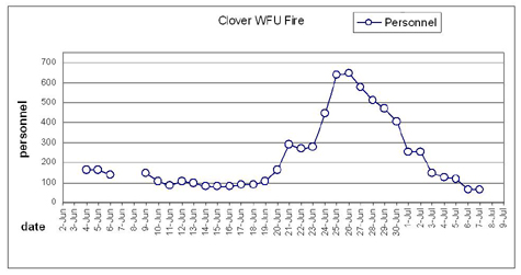
Total Personnel: 5
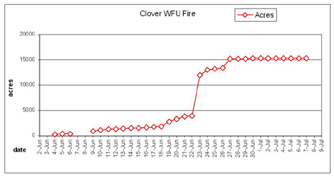
Size: 15,300 acres
Percent Contained: 90%
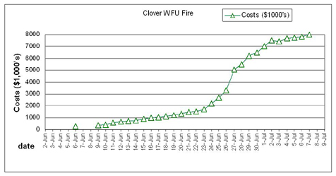
Costs to Date: $8,315,000
Fire area received ~0.1 inches of rain last night.
***************
Situation as of 07/08/08 5:00 PM
Total Personnel: 78
Size: 15,300 acres
Percent Contained: 70%
Costs to Date: $8,159,714
Fire use module will continue moving east along north edge of fire completing line and rehab work as they progress. Helicopter with Palm IR operator to check fire’s edge. Area closure will be lifted effective 7/9 which will include the re-opening of the Pacific Crest Trail. FUMT will transition with type 3 organization and plans to transfer command at 1800 on 7/9.
***************
Situation as of 07/07/08 2:00 PM
Total Personnel: 67
Size: 15,300 acres
Percent Contained: 70%
Costs to Date: $7,989,626
Helicopters are being shared with the Piute fire.
***************
Situation as of 07/05/08 6:00 PM
Total Personnel: 117
Size: 15,300 acres
Percent Contained: 70%
Costs to Date: $7,727,359
Acreage increase is due to more accurate mapping, 5612 acres on Sequoia NF 9688 acres on Inyo NF.
No increase in fire activity with winds of 25 mph over the fire in the afternoon and evening.
***************
Situation as of 07/04/08 6:00 PM
Total Personnel: 128
Size: 15,262 acres
Percent Contained: 70%
Costs to Date: $7,678,932
Northern Rockies Fire Use Management Team (Hutton (T)/Cook) transitioned with outgoing team (Johnson) at 0600 today. Increased winds of 35-40 mph increased fire activity in interior islands of unburned fuels.
***************
Situation as of 07/03/08 6:00 PM
Total Personnel: 148
Size: 15,262 acres
Percent Contained: 70%
Costs to Date: $7,400,000
Diane Huttons’s RMIMT Fire Use team will take the fire over at 06:00 tomorrow. The Sequoia NF’s demand for WFU does not stop despite catastrophic failure. Public in Kennedy Meadows and elsewhere continue to have their concerns ignored.
***************
Situation as of 07/03/08 6:00 AM
Total Personnel: 253
Size: 15,262 acres
Percent Contained: 70%
Costs to Date: $7,500,000
***************
Situation as of 07/01/08 6:00 PM
Total Personnel: 253
Size: 15,262 acres
Percent Contained: 70%
Costs to Date: $7,000,000
***************
Situation as of 06/30/08 6:00 PM
Total Personnel: 405
Size: 15,262 acres
Percent Contained: 60%
Costs to Date: $6,500,000
Continued to contain the south flank and the threat of the movement towards Kennedy Meadows. Continued to secure all divisions. Patrolling, mop-up, and monitoring on all divisions. Cool hot areas on Div. M with aircraft.
Structures in Kennedy Meadows continue to be of concern.
Five crews will be released 7/1/08.
***************
Situation as of 06/29/08 6:00 PM
Total Personnel: 471
Size: 15,235 acres
Percent Contained: 50%
Costs to Date: $6,200,000
Continued to secure line Divisions O and Y with aircraft. Patrolling and monitoring other divisions. Spot fire on Div. O contained with aircraft. Continued to contain the south flank and the threat of the movement towards Kennedy Meadows.
Structures in Kennedy Meadows continue to be of concern. Fire weather watch for predicted southeast winds, high temperatures, and thunder storms are in effect until 20:00.
***************
***************
Situation as of 06/28/08 6:00 PM
Total Personnel: 513
Size: 15,235 acres
Percent Contained: 40%
Costs to Date: $5,500,000
Continued to secure line Divisions O and Y with aircraft. Patrolling and monitoring other divisions. Pick up spot fire on Div. M contained with aircraft. Continued need for extra crews to contain the south flank and the threat of the movement towards Kennedy Meadows.
Structures in Kennedy Meadows continue to be of concern. Fire weather watch for predicted southeast winds, high temperatures, and thunder storms are of concern for tomorrow’s operational period.
***************
Situation as of 06/27/08 6:30 AM
Total Personnel: 578
Size: 15,217 acres
Percent Contained: 25%
Costs to Date: $5,070,000
Initiated transition from zone incident management teams (Harvey) (Johnson) to single IMT (Johnson).
Clover East: Continued to secure line and mopup in Divisions L and O. Patrolling and monitoring Divisions M & N. Clover West: Continued need for extra crews to contain the south flank and the threat of the movement towards Kennedy Meadows. Structures in Kennedy Meadows continue to be of concern.
Fire Size and Containment: East 5568 ac. 50 percent containment, West 9650 ac. 20 percent containment. Increase in fire size due to more precise mapping.
***************
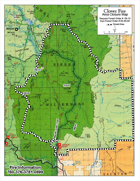
Clover Fire Area Closure. Effective June 25 through July 8 or until the Clover Fire is fully suppressed. Prohibited:
1. Entering or being upon the Clover Fire Area, as shown on the attached map. 36 CFR 251.52(a)
2. Being on any National Forest System road within the Clover Fire Area, as shown on the attached map. 36 CFR 251.54(a)
3. Being on any National Forest System trail within the Clover Fire Area, as shown on the attached map. 36 CFR 251.55(a)
Pursuant to 36 CFR 251.50(a), the following persons are exempt from this order: Any Federal, State, or local officer, or member of an organized rescue or fire fighting force in the performance of an official duty.
A violation of these prohibitions is punishable by a fine of not more than $5,000 for an individual of $10,000 for an organization, or imprisonment for not more than six months, or both 16 USC 551 and 18 USC 3559, 3571, and 3581.
Signed Jeff Marsolais, Acting Forest Supervisor, Inyo National Forest and Tina Terrell, Forest Supervisor, Sequoia National Forest
***************
Situation as of 06/26/08 8:00 AM
Total Personnel: 647
Size: 13,400 acres
Percent Contained: 15%
The potential for extreme fire behavior with spotting and tree torching continues this afternoon. A structure protection group lead by Tulare County Fire Department is in place at Kennedy Meadows.
***************
Situation as of 06/25/08 8:00 AM
Total Personnel: 640
Size: 13,250 acres
Percent Contained: 10%
***************
Situation as of 06/23/08 9:00 PM
Total Personnel: 445
Size: 13,049 acres
Percent Contained: unreported
Costs to Date: $2,200,000
Clover Fire Blows Up! Fire expanded three-fold yesterday, crossed the crest of the Sierras and burned nearly to Hwy 395.
The fire has been split at the crest of the Sierra’s. A second Type 2 team to manage the east side of the incident has been ordered. The north and west flanks of the fire will continue to be managed as Fire Use and the south and eastward spread will be managed under suppression tactics. Two structures in Dunmoving and ten in Kennedy Meadows may be threatened.
Failure is no reason to stop repeating your mistakes!!!
***************
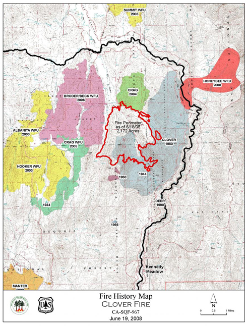
Clover WFU Fire map as of 06/18 — 2,172 acres
Situation as of 06/22/08 6:00 PM
Total Personnel: 269
Size: 3,929 acres
Percent Contained: unreported
Costs to Date: $1,500,000
Transition to Allen Johnson’s Type 2 Team at 0600 this morning. Continued progress was made on the south flank. The east flank became active in the early afternoon and containment efforts were lost on some portions of the line. The fire made a significant run to the east and has jumped the Kern River. Helicopters were used to help slow the east flank and for support on the rest of the fire. Air tankers not available. De-mob of Beckman’s team
***************
Situation as of 06/21/08 PM
Total Personnel: 289
Size: 3,898 acres
Percent Contained: unreported
Costs to Date: $1,475,000 (reported, but not up to date)
Transitioning to a Type 2 IMT (Johnson) tomorrow at 0600 hrs for active suppression actions. Activities include handline construction, helicopter water drops, and utilization of air tankers during the morning hours. CA FUMT will demob tomorrow.
Fire starts across CA from lightning of 06/20-21 have put considerable pressure on firefighting resources. The Clover WFU has and is pulling resources away from critical need areas. This fire could have been suppressed in early June at less than 100 acres and less than $100,000. Instead $2 million have been spent, 4,000 acres have burned, and the rest of the state has been placed at reduced readiness for fires that are occurring elsewhere today.
The Clover WFU was never subject to any NEPA process or public involvement. Those actions could have prevented the serious mistakes made. If the individuals responsible for the Clover WFU are held accountable, it might help prevent future poor decision-making.
Update 06/22/08 noon:
The Sequoia National Forest has reported 25 fires from lightning storms of yesterday.
***************
Situation as of 06/20/08 PM
Total Personnel: 165
Size: 3,350 acres
Percent Contained: unreported
Costs to Date: $1,600,000 (estimated)
Increased fire activity with spotting up to 0.25 miles along the southern flank. Several helicopters continued to make strategic water drops, utilzing airtankers. Seven handcrews are working to construct handline.
Pacific Crest Trail hikers are being rerouted out of the fire area. [See Comments for Sequoia NF Media Alert re PCT]
Wind NW-W 11-30 mph.
It has been reported that officials at the Sequoia and Inyo NF approved the Stage III WFIP Plan. The costs for the Clover Fire do not come out of their budgets.
No reports as yet on the resource benefits accruing from this Wildland Fire Used For Resource Benefit. No cost/benefit analysis. No impact analysis on wildlife, watershed, airshed, recreation, anthropological sites, or other resource values.
***************
Situation as of 06/19/08 PM
Total Personnel: 107
Size: 2,842 acres
Percent Contained: unreported
Costs to Date: $1,201,633
Fire has grown by 50 percent in the last two days. Two Type I Hotshot Crews and additional helicopters have been ordered. They are expected to arrive Friday morning.
Meanwhile, it is reported, “Fire scientists to monitor fire monitoring equipment on plots they established on Wednesday to study fire behavior.”
A Stage III WFIP has been presented to the Sequoia and Inyo National Forests. Whether there was some sort of ceremony involved was not reported, nor what they did with it.
***************Situation as of 06/19/08 AM
Total Personnel: 89
Size: 1,917+ acres
Percent Contained: unreported
Costs to Date: $1,099,000+
On Wednesday afternoon 20 mph NW winds pushed the fire against pre-defined management action points (trigger points). This caused fire managers to implement additional management actions to contain the SW edge of the fire. Additional crews and helicopters have been ordered.
The Pacific Crest Trail is currently open but many hikers are using alternate routes to bypass the fire. Warning signs are posted and hikers are discouraged from traveling at night. Hikers are encouraged to hike through the fire area before 1 pm.
***************
Situation as of 06/18/08 4:00 PM
Total Personnel: 89
Size: 1,917 acres
Percent Contained: unreported
Costs to Date: $1,099,000
Moderate intensity and spread along southwest flank with group tree torching and some short-range spotting. Presenting Stage III WFIP to Inyo and Sequoia Forest staffs in afternoon.
***************
Situation as of 06/17/08 4:00 PM
Total Personnel: 89
Size: 1,788 acres
Percent Contained: unreported
Costs to Date: $1,048,000
Continue monitoring fire behavior, spread, and smoke. Checking any fire spread that is in a southerly or easterly direction. Presenting Stage III WFIP to Sequoia and Inyo National Forests
***************
Situation as of 06/16/08 6:00 PM
Total Personnel: 84
Size: 1,670 acres
Percent Contained: unreported
Costs to Date: $985,000
Significant Events: Finishing construction of handline to check any southerly fire spread Improving Jackass Trail for packtrain access. Developing Stage III WFIP. (So far that plan has been in development since 06/09, a week — admin).
Remarks: Fire Behavior Assessment Team will begin monitoring fire behavior and effects tomorrow. (What have they been doing since they arrived on 06/11? — admin).
***************
Situation as of 06/15/08 6:00 PM
Total Personnel: 81
Size: 1,597 acres
Percent Contained: unreported
Costs to Date: $873,000
***************
Situation as of 06/14/08 6:00 PM
Total Personnel: 81
Size: 1,570 acres
Percent Contained: unreported
Costs to Date: $740,000
***************
Situation as of 06/13/08 6:00 PM
Total Personnel: 99
Size: 1,478 acres
Percent Contained: unreported
Costs to Date: $700,000
***************
Situation as of 06/12/08 5:00 PM
Total Personnel: 108
Size: 1,311 acres
Percent Contained: unreported
Costs to Date: $650,000
***************
Situation as of 06/11/08 PM
Total Personnel: 85
Size: 1,311 acres
Percent Contained: unreported
Costs to Date: $600,000
Fire is being monitored.
***************
Situation as of 06/11/08 AM
Total Personnel: 60
Size: 1,164+ acres
Percent Contained: 30%
Individual and group tree torching in 25 mph winds. Personnel continue to monitor fire progression, fire effects and behavior, and smoke.
For further information, please contact Cindy Thill, Public Affairs Officer, Kern River Ranger District at (760) 376-3781.
***************
Vicinity maps:
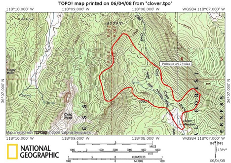
Clover WFU Fire map 06/04/08 but updated to fire size of ~800 acres. Courtesy InciWeb.
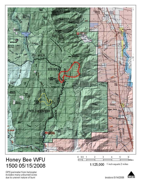
Honeybee WFU Fire map (red) of 05/15/08 but updated to fire size of ~1200 acres. Clover Fire in yellow (~800 acs). Note that each square section on the map is 640 acres. Honeybee WFU Fire updates [here]. Courtesy InciWeb and the Inyo NF.
***************
Situation as of 06/10/08
Total Personnel: 105
Size: 1,164 acres
Percent Contained: 30%
Costs to Date: $400,000
RED FLAG WARNING IN EFFECT FROM 11 AM THIS MORNING TO 9 PM THIS EVENING. WEST WIND 15 TO 25 MPH WITH GUSTS TO 40 MPH.
USFS removed firefighting crews today at 1800 hours. Clover Fire now officially in Let It Burn status.
***************
Situation as of 06/09/08
Total Personnel: 47
Size: 983 acres
Percent Contained: 30%
Costs to Date: $350,000
Pacific Crest Trail open, firefighters assisting hikers through the fire.
Fire made a 350 + acre run 06/08/08 and moved north out of Crag Creek, and 200 additional acres burned today. Expected growth up to 300 acres per day for the next 3 days.
***************
The Clover Fire has been declared a “wildland fire-use” fire as of 06/06/08.
From InciWeb: Upon initial investigation the probable cause of fire appeared to be human-caused. Further investigation has revealed the cause more likely to be lightning. Each lightning caused fire is evaluated to determine the optimal response (suppression or fire use). When making decisions, fire managers consider the fire’s proximity to private property, potential smoke impacts, fire fighter safety, and other fire activity occurring in the area. The main focus for fire fighting personnel still remains to hold the fire from spreading south toward the community of Kennedy Meadows.
No NEPA process was instigated or even contemplated for this Federal management action on public property. No evaluation of impact to endangered species, water or air quality, no public hearings, no public input, and no legal review whatsoever was performed.
No actual detection or investigation of the fire ignition was done.
From InciWeb: Initial investigation into the lightning detection/reporting program did not show recent strikes in the Clover Fire vicinity. The detection program is a computer program which may have not recorded all strikes due to a glitch in the system.
Situation as of 06/06/08 at 2 pm
Total Personnel: 140
Size: 382 acres
Percent Contained: 30%
Active fire on the north side. High winds reported.
Costs to Date: $250,000
***************
Situation as of 06/05/08
Total Personnel: 165
Size: 382 acres
Percent Contained: 30%
***************
Current Situation
Total Personnel: 165
Size: 339 acres
Percent Contained: 30%
Summary: same vicinity as the Honeybee Fire [here].
The Pacific Crest Trail will remain OPEN with a “warning sign” posted for public safety. Hikers in the fire area will be escorted, during daylight hours only, through the fire area. The escorted section is approximately 3/4 of a mile. It is highly discouraged to try and hike in the area after dark - many hikers have mistaken the fireline for the trail and put themselves in a dangerous situation.
Fire crews are constructing direct line as much as possible, securing the south end. Active fire in brush on the north end.
Red Flag Warning in effect until 8 pm PST June 4 for strong winds and low relative humidity over much of southeast California. Wind gusts predicted up to 30 mph. A cold front moving through is producing very windy conditions and isolated thunderstorms. Winds are expected to subside by morning as the front moves through the region.
