Arizona California Colorado Idaho Montana Nevada New Mexico Oregon Utah
by admin
leave a comment
Lightning Storms of June 30
Vaisala Lightning Explorer [here] has been registering significant lightning strikes this afternoon in Eastern Oregon, Northern Nevada, Central and Southern Idaho, Utah, Southern Montana, Western Wyoming, Western Colorado, Northern Arizona, and Northwestern New Mexico.
Seep Lakes Fire
Location: ~3 miles W of Warden, Grant Co., WA
Specific Location: Lat 46° 57′ 49″ Lon 119° 8′ 28″
Date of Origin: 06/29/08
Cause: human
Situation as of 07/01/08 2:00 PM
Total Personnel: 120
Size: 1,950 acres
Percent Contained: 100%
Resources: Grant Co. - 5 engines, 14 overhead, DNR - 1 crew, 1 helicopter, Private - 1 crew. Demobilize all resources by noon.
***************
Situation as of 07/01/08 7:00 AM
Total Personnel: 65
Size: 1,970 acres
Percent Contained: 70%
***************
Situation as of 06/29/08 11:00 AM
Total Personnel: unknown
Size: 3,000 acres
Percent Contained: 0%
Grass fire. Approximately 100 people have been evacuated and 55 structures are threatened. A Type 3 IMT is committed and State Mobilization has been authorized.
CA Fire Map Monday 06/30 AM
Click map for larger image (3.5 MB).
California Summary 06/30/08
Total Fires: 1,459
Total Acres Burned: 379,115
These numbers are total fires and acres that have occured from state, local and federal firefighting agencies beginning June 20, 2008.)
Resources Committed
Personnel Committed: 19,240
Fire Engines: 1,429
Hand Crews: 491
Dozers: 365
Water Tenders: 413
Helicopters: 94
(Updated 6/30 at 9:00 a.m.)
Highway closures: State highways and local roads are closed throughout California due to wildfire activities. Closures and delays are in place for State Highways 1 (Big Sur Area), 36, 70 and 96 (delays). Numerous county and local roads are closed as well. Travelers are advised to seek current information from local law enforcement.
Evacuations: Areas of Butte and Shasta counties are under evacuation orders at this time. Precautionary evacuation orders are in place for areas in Butte, Kern, Mariposa, Mendocino, Shasta and Trinity counties. Residents are advised to monitor the fire situation in their areas, check with local law enforcement agencies for information, and be prepared to evacuate when necessary.
Structures Threatened: 7,672 residences, 136 commercial, 2,851 outbuildings.
Structures Destroyed: 30 residences, 1 commercial, 20 outbuildings.
Lane 2 Fire
Location: ~50 N of Phoenix on Hwy 17, community of Crown King, Yavapai Co. AZ
Specific Location: Lat 34° 10′ 25″ Lon 112° 20′ 23″
Date of Origin: 06/28/08
Cause: human
Situation as of 07/07/08 6:00 aM
Total Personnel: 299
Size: 9,629 acres
Percent Contained: 95%
Costs to Date: $5,143,321
Structures Destroyed: 5 residences , 1 comercial building , 12 outbuildings
Lorena Gulch and Horsethief Basin area remained closed as powerlines are being reconstructed and hazards mitigated. Rehabilitation work progressing across the eastern and southern divisions of the fire. Resources compiled final count of structures damaged.
Fire area received precipitation last night. Incident Command will be transferred back to the local unit at 18:00.
***************
Situation as of 07/05/08 8:00 AM
Total Personnel: 585
Size: 10,100 acres
Percent Contained: 50%
11 Structures destroyed. Increase in the number of destroyed structure were due to yesterday’s discovery; they were burned on 6/29 (the first day of the fire). APS restored power to the community of Crown King; and Wild Flower and Towers infrastructure sites on 7/2. Mop-up and patrol area surrounding the communities of Crown King and Horsethief Basin Summer Homes. Contingency line is in-place south of Horsethief Basin Summer Homes (DIV D) and ready for burnout if fire growth warrants.
***************
Situation as of 07/03/08 6:00 PM
Total Personnel: 608
Size: 9,600 acres
Percent Contained: 10%
Costs to Date: $2,900,239
Structures Destroyed: 3 residences , 4 outbuildings
Extreme fire behavior on the eastern flank (DIV C). Moderate fire on southern flank (DIV’s D and Y).
***************
Situation as of 07/02/08 6:00 PM
Total Personnel: 646
Size: 7,580 acres
Percent Contained: 10%
Costs to Date: $1,961,501
Structures Threatened: 291 residences, 10 commercial, 274 outbuildings. Structures Destroyed: 3 residences, 4 outbuildings.
Plume over fire developed at 1000 due to limited inversion and extreme fire behavior. East flank terrain driven running crown fire in the drainage south of Twin Peaks (2 miles NE of Horsethief Basin Summer Homes).
***************
Situation as of 07/02/08 8:30 AM
Total Personnel: 447
Size: 7,200 acres
Percent Contained: 5%
Extreme fire behavior on the eastern flank due to winds from afternoon thunder cells, and hot and dry conditions. Spotting and running fires in dead ponderosa pine. Fire perimeter expanded on eastern flank and moving towards the ridge above Horsethief Basin Summer Homes.
There will be a community meeting at Mayer Recreation Center today.
***************
Situation as of 06/30/08 6:00 PM
Total Personnel: 264
Size: 5,300 acres
Percent Contained: 0%
Evacuation Center at Mayer High School in Spring Valley.
Area road blocks were established to limit traffic to the area on Senator Highway at Goodwin and at the Crown King Road at Cleator. Powerlines were deactivated to the Crown King area to include the citical infrastructure on Towers Mountain and Wildflower Mountain.
Continual threat to Crown King with fire approaching community from Poland Creek Basin to the east.
***************
Situation as of 06/29/08 11:00 PM
Total Personnel: 77
Size: 500 acres
Percent Contained: 0%
Community of Crown King evacuated. Evacuation Center set up at Spring Valley High School.
Structures Threatened: 430 PRIM , 10 COMM , 100 OUTB
Terrain and wind driven fire. Torching and spotting up to 1/4 mile. Fire spread in all directions.
Piute Mountain Fire
Location: Piute Mountain in the Sequoia NF, 8 miles N of Twin Oaks, Kern Co. CA
Specific Location: Lat 35° 25′ 51″ Lon 118° 24′ 4″
Date of Origin: unknown, reported 06/29/08
Cause: human
Situation as of 07/16/08 6:00 PM
Total Personnel: 501
Size: 37,026 acres
Percent Contained: 95%
Costs to Date: $23,647,000
Evacuations continue to remain in effect throughout the fire area, related to potential flash flooding and not fire activity. Any further evacuation operations will be handled solely by the Kern County Sheriffs Department.
***************
Situation as of 07/15/08 6:00 PM
Total Personnel: 660
Size: 37,026 acres
Percent Contained: 75%
Costs to Date: $23,175,000
The Forest Closure in the Piute Mountain area remains in effect. The Bureau of Land Management’s temporary closures of motorized vehicles in the Piute Fire area remains in effect. The flash flood watch issued for the Erskine Creek drainage is still in effect. A recommended evacuation also remains in effect for all residence in the town of Lake Isabella, on both sides of Erskine Creek from the mouth of Erskine Creek Canyon at the pavement’s end to the Kern River due to the threat of flash floods. Evacuations remain in effect for Brown Meadow, French Meadow, and Camp Nick Williams and Red Mountain.
The remaining open line is inaccessible. Efforts are being placed on aerial surveillance and bucket drops to secure final sources of heat in those locations. Infrared imagery has been requested to confirm the effectiveness of these efforts.
Resources are being demobilized commensurate with weather and fire conditions. This incident is being managed under unified command with USFS and Kern County Fire Department. Due to the reduction in the threat to the State Responsibility Area (SRA), Cal Fire withdrew from unified command today.
***************
Situation as of 07/14/08 6:00 PM
Total Personnel: 1,100
Size: 37,026 acres
Percent Contained: 70%
Costs to Date: $23,000,000
Structures Destroyed: 6 residences , 45 outbuildings (some of which were historical cabins)
The Forest Closure in the Piute Mountain area remains in effect. The Bureau of Land Management’s temporary closures of motorized vehicles in the Piute Fire area remains in effect. The flash flood watch issued for the Erskine Creek drainage is still in effect.
A recommended evacuation was issued for all residence in the town of Lake Isabella, on both sides of Erskine Creek from the mouth of Erskine Creek Canyon at the pavement’s end to the Kern River.
Evacuations remain in effect for Brown Meadow, French Meadow, Camp Nick Williams and Red Mountain.
Although evacuations are no longer due to fire danger evacuations will remain in effect due to the threat of flash floods The flash flood recommended evacuation will remain in effect. Area received ~0.1 inches of rain last night.
Last night’s high altitude IR flight and a more detailed low altitude daytime IR flight indicated some heat is still detectable. The IR information will be used to direct crews for mop-up.
Resources are being demobilized commensurate with weather and fire conditions. Due to the weather conditions night operations will be limited to one strike team of engines patrolling the fire. Crews will remain available in camp, to respond to emergencies.
***************
Situation as of 07/13/08 5:00 PM
Total Personnel: 1,590
Size: 37,026 acres
Percent Contained: 64%
Costs to Date: $22,505,000
Fire activity moderated due to higher humidities. Direct attack continued on the northern perimeter near Dry Meadow and Bob Rabbit Canyon.
A flash flood watch was issued for the Thompson Canyon and Erskine Creek drainage at 1600.
***************
Situation as of 07/12/08 5:00 PM
Total Personnel: 1,523
Size: 36,183 acres
Percent Contained: 46%
Costs to Date: $20,700,000
The fire was active on the northwest perimeter (Division M) and crews continued with burnout operations to stay ahead of the fire. Crews completed handline on the northeastern perimeter near Cortez Canyon. Hand firing operations were completed in the southern portion of the western flank (Division A) along existing dozer line. This was supplemented with aerial ignition. Direct attack continued on the northern perimeter near Dry Meadow and Bob Rabbit Canyon with the support of helicopter bucket drops.
Actions planned may be modified based upon flash flooding events occurring in the fire area.
***************
Situation as of 07/11/08 5:00 PM
Total Personnel: 1,562
Size: 35,078 acres
Percent Contained: 38%
Costs to Date: not updated
The fire was active on the northwest perimeter (Division M) and established itself in the upper part of Erskine Canyon. Crews made excellent progress with direct control efforts on the northeastern perimeter near Cortez Canyon. Crews continued firing operations in southern protion of the western perimeter (Division A) along existing dozer line. Direct attack continued on the northern perimeter near Dry Meadow and Bob Rabbit Canyon with the support of helicopter bucket drops. Work was completed on contingency lines on the northern perimeter near Squirrel Valley and also the western perimeter in the Havilah, area.
The fire is less active with little growth in the north. Limited grown in the southwest is associated with burnout operations.
***************
Situation as of 07/10/08 5:00 PM
Total Personnel: 1,433
Size: 34,852 acres
Percent Contained: 32%
Costs to Date: $17,250,000
Direct attack began on the northern perimeter near Dry Meadow with the support of helicopter bucket drops and retardant. Work continued on contingency lines on the northern perimeter and also the western perimeter in the Havilah area. The Recommended Evacuation was lifted in the Havilah area at 1500.
To date, 35 additional outbuildings associated with past (historical) mining activity in this area have been found, for a total of 45 outbuildings and 6 residences lost on the incident.
***************
Situation as of 07/09/08 5:00 PM
Total Personnel: 1,359
Size: 33,152 acres
Percent Contained: 28%
Costs to Date: $13,100,000
Structures Destroyed: 3 residences , 9 outbuildings
The fire was active on the northern perimeter. Crews made excellent progress with direct control efforts on the eastern perimeter near Kelso Valley. Local resources are engaged in active structure protection in the Havilah area. Work began on new contingency lines on the northern perimeter and also the western perimeter in the Havilah area. The community of Havilah remains under a recommended evacuation notice.
***************
Situation as of 07/07/08 5:00 PM
Total Personnel: 1,191
Size: 26,285 acres
Percent Contained: 22%
Costs to Date: $11,494,098
Strong southeasterly winds pushed the fire actively to the north and west. Control lines were abandoned on the western perimeter as the fire continues to move west toward the community of Havilah. Local resources are engaged in active structure protection in the Havilah area. Contingency lines were continued on the north perimeter but resources were pulled off this operation due to active fire behavior. The community of Havilah was issued a recommended evacuation notice.
Extreme fire behavior has been reported in Haight Canyon and the head of Erskine Creek with crowning and spotting.
***************
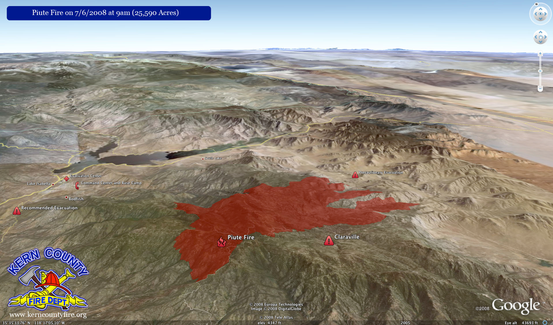
Piute Mountain Fire Google Earth map, 07/07/08, courtesy Kern Co. Fire Dept. [here]. Click map for larger image (1.0 MB).
****************
Situation as of 07/06/08 5:00 PM
Total Personnel: 1,270
Size: 25,591 acres
Percent Contained: 26%
Costs to Date: $9,900,000
The fire activity lessened on the eastern perimeter due primarily to lighter fuels. Suppression forces continue to deepen line construction on the southern perimeter towards the east. Crews continued line construction and burnout on the western perimeter near Saddle Spring Road and began work on a contingency line. A large contingency line was begun on the northern perimeter with the use of hand crews and mechanical equipment.
***************
Situation as of 07/05/08 5:00 PM
Total Personnel: 1,267
Size: 21,478 acres
Percent Contained: 26%
The fire was active in all divisions and continued to move east due to strong southwesterly winds. Crews are attempting to keep the fire north of Piute Mountain Road with the aid of aerial retardant.
A new precautionary evacuation notice was issued for all residents west of Kelso Valley Road and east of the Sequoia National Forest boundary; and from the Kelso Valley Road at the junction with the Piute Mountain Road on the on the south and north to include the community of Cortez Canyon. A precautionary evacuation is also in place for Sorrel Peak Road south of the Piute Mountain Road.
***************
Situation as of 07/05/08 3:00 PM
Total Personnel: 1,261
Size: 19,010 acres
Percent Contained: 18%
***************
Situation as of 07/04/08 5:00 PM
Total Personnel: 1,247
Size: 18,203 acres
Percent Contained: 18%
Costs to Date: $6,700,000
Suppression forces made good progress on line construction on the southern perimeter towards the east. A slopover occurred along the Piute Mountain Road near Claraville. Crews were able to control the slopover with the aid of aerial retardant. Crews continued line construction on the western perimeter near Saddle Spring Road and began to make plans for a contingency line. Indirect line was constructed in the SRA (State Responsibility Area) for perimeter control. Line construction began in the NW and NE portion of the fire.
The fire has been very active on the eastern side today with spotting 1/4 to 1/2 mile and a probability of ignition near 100%.
***************
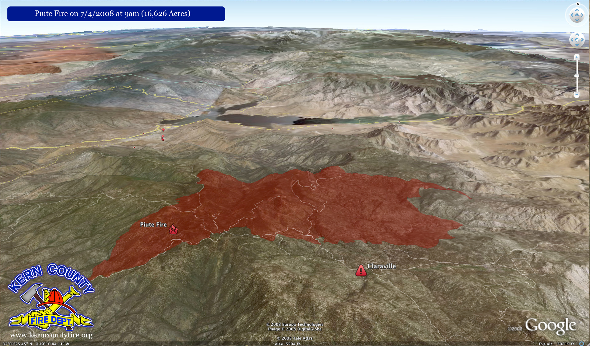
Piute Mountain Fire Google Earth map, 07/04/08, courtesy Kern Co. Fire Dept. [here]. Click map for larger image (1.4 MB).
Black Mesa Fire
Location: 15 miles northeast of San Carlos, Gila Co., CA
Specific Location: Lat 33° 27′ 29″ Lon 110° 23′ 54″
Date of Origin: 06/26/08
Cause: Lightning
Situation as of 06/29/08 6:00 PM
Total Personnel: 52
Size: 1,744 acres
Percent Contained: 30%
***************
Situation as of 06/27/08 7:30 PM
Total Personnel: 5
Size: 1,744 acres
Percent Contained: 16%
Active fire activity at 30% northeast and northwest side of the perimeter. Allowing fire to back into Oak Creek drainage along the northern perimeter.
Natural barriers and monsoonal season should contain and extinguish the fire.
Jack Wood WFU Fire
Location: ~40 miles SE of Willcox, Cochise Co., AZ
Specific Location: SE of Chiricahua National Monument, S of Paradise, Coronado NF, Lat 31° 45′ 53″ Lon 109° 9′ 55″
Date of Origin: 06/23/08
Cause: Lightning
Situation as of 07/02/08 5:00 PM
Total Personnel: not reported
Size: 8,241 acres
Percent Contained: 90%
Costs to Date: $170,000
estimated containment 07/07
***************
Situation as of 06/27/08 5:00 PM
Total Personnel: 66
Size: 8,000 acres
Percent Contained: 75%
Costs to Date: $130,000
Planned Actions: Burning operations in Horseshoe Canyon as fire backs to road.
Oregon Lightning Fire Update
Initial Attack Fire Activity Summary 06/30 AM
Central Washington – 10 new and numerous smokes. Four new in the Goldendale area will be complexed with a Type 3 IC. Two largest are 50+ acres each but no problems are reported.
Yakama BIA – Will have recon up at 0800. No problems reported.
Central Oregon – 12 new. Class AB and no problems reported.
Mt Hood NF – 12 confirmed, all Class A.
Warm Springs BIA – 2 confirmed. Largest is 75 acres located near Kaneetah. Fire is staffed with no problems reported.
Klamath Falls – 4 – 5 new. All Class A with no problems.
Washington State Patrol reports numerous fires in the Columbia Basin but no information is available yet.
***************
Initial Attack Fire Activity Summary, June 29 AM:
Rogue River NF – 1 new Class AB. No problems.
Medford ODF - 5 new. Largest is 2 ac. No problems.
Umpqua NF – has several new. All Class AB with no problems yet.
Douglas FPA– Has several new. No problems reported.
Klamath Falls – Crater Lake NP has 1 new at 1/4 ac. No problems.
Eugene –Will put detection up at 1100. Got some precip at lower elevations last night.
Central Oregon – 2 human-caused on 6/28 for 32 acres.
Planned prescribed fire activity today: None.
Weather Synopsis: Widespread thunderstorms in Oregon today, turning moderately wet towards evening.
CA Fire Map Sunday 06/29 AM
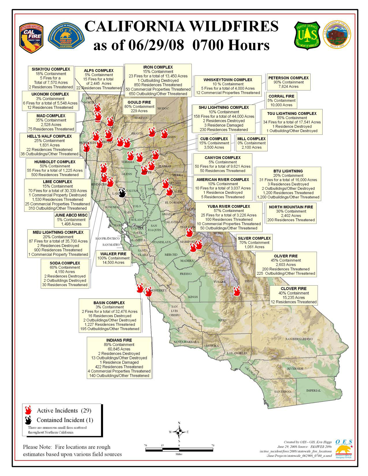
Click map for larger image (1.1 MB).
RED FLAG WARNING in effect from 1 pm this afternoon to 5 am PDT Monday for Northeast California including E Shasta Co., Burney Basin, W. slope Sierra Nevada including Plumas NF; Southern and Central Oregon; and Northern and Central Nevada for scattered dry thunderstorms. Many storms today will produce little to no rainfall due to dry air above the surface. By Sunday more storms will become wetter but shorter rainfall duration is expected due to increased storm motion.
California Summary 06/29/08
Total Fires: 1,420
Total Acres Burned: 356,134 (556 sq mi)
Resources Committed
Personnel Committed: 18,608
Fire Engines: 1,377
Hand Crews: 465
Dozers: 331
Water Tenders: 375
Helicopters: 92
(These numbers are totals from state, local and federal firefighting agencies. Updated 6/28 at 9:00 p.m.)
Highway closures: State highways and local roads are closed throughout California due to wildfire activities. Closures and delays are in place for State Highways 1 (Big Sur Area), 32, 36, 70, 96, and 151. Numerous county and local roads are closed as well. Travelers are advised to seek current information from local law enforcement.
Evacuations: Areas of Butte, Monterey, and Shasta counties are under evacuation orders at this time. Precautionary evacuation orders are in place for areas in Butte, Lassen, Mariposa, Mendocino, Shasta and Tehama counties. Residents are advised to monitor the fire situation in their areas, check with local law enforcement agencies for information, and be prepared to evacuate when necessary.
Structures Threatened: 7,589 residences, 135 commercial, 2,856 outbuildings. Structures Destroyed: 29 residences, 1 commercial, 21 outbuildings.
Lightning Storms of June 28-29
Vaisala Lightning Explorer [here] has been registering significant lightning strikes this afternoon along the Oregon-California border. This evening more lightning stuck in the Oregon Cascades. As I type in the early hours of Sunday morning, lightning is flashing to the south in Lane County and moving this direction (Linn Co., OR). Vaisala indicates that the electric storm extends to at least Bend on the eastside of the Cascades.
It is dry lightning, without or with very little rain.
Tomorrow and over the next few days expect numerous fires to be reported in Oregon.
The last dry lightning storm (a week ago) ignited over 1300 fires in California and began what will prove to be the worst fire season in that state’s history.
InciWeb Problems Are Bull…
InciWeb has allegedly been having “server troubles.” I can’t get on, and no one else I know can either. The “server problems” have been cropping up since last summer.
It takes a day at most and few hundred bucks to add server capacity. Something else is going on.
NF’s with fires rarely post maps anymore, and few updates, and certainly not in a timely way. They all say “go see InciWeb,” but InciWeb is dysfunctional, and everyone knows it.
The same is true of the GACC’s, which post their morning reports 24 hours or more late. The SoCal GACC seems to be working now after a 4 day hiatus. The Southwest GACC hasn’t posted since Thursday. They all say “go see InciWeb.”
The National Fire News used to refer people to InciWeb, but for two weeks they have been running a blurb that says:
Inciweb is having technical difficulties due to the high volume of Internet users trying to access these sites. The technical staff is working to restore access to the site as soon as possible.
The InciWeb technical staff must be tied up in a closet.
Last summer the National Fire News posted the office phone numbers of InciWeb personnel after being annoyed by the complaints. How rude! I threatened the folks at Boise (the National Interagency Fire Center that produces the National Fire News) that I would post their office and home phone numbers, just to see how they liked that kind of thing. They took their little nastiness down.
I think a dysfunctional InciWeb is the USFS’s way of giving citizens the finger. They could fix it if they wanted to, but instead choose not to, while supposedly relying on it. Their supposed efforts to inform are actually efforts to obfuscate, confuse, and cover up.
It’s total bull. I could fix InciWeb in a few minutes. So could any ISP techie.
So while the most extreme fire crisis in modern history is blasting away in densely populated California, and while millions of people’s properties and lives are at stake, the USFS chooses deliberately to hide the facts and monkeywrench their own outreach and information system. Is it a foul, murderous plot or what?
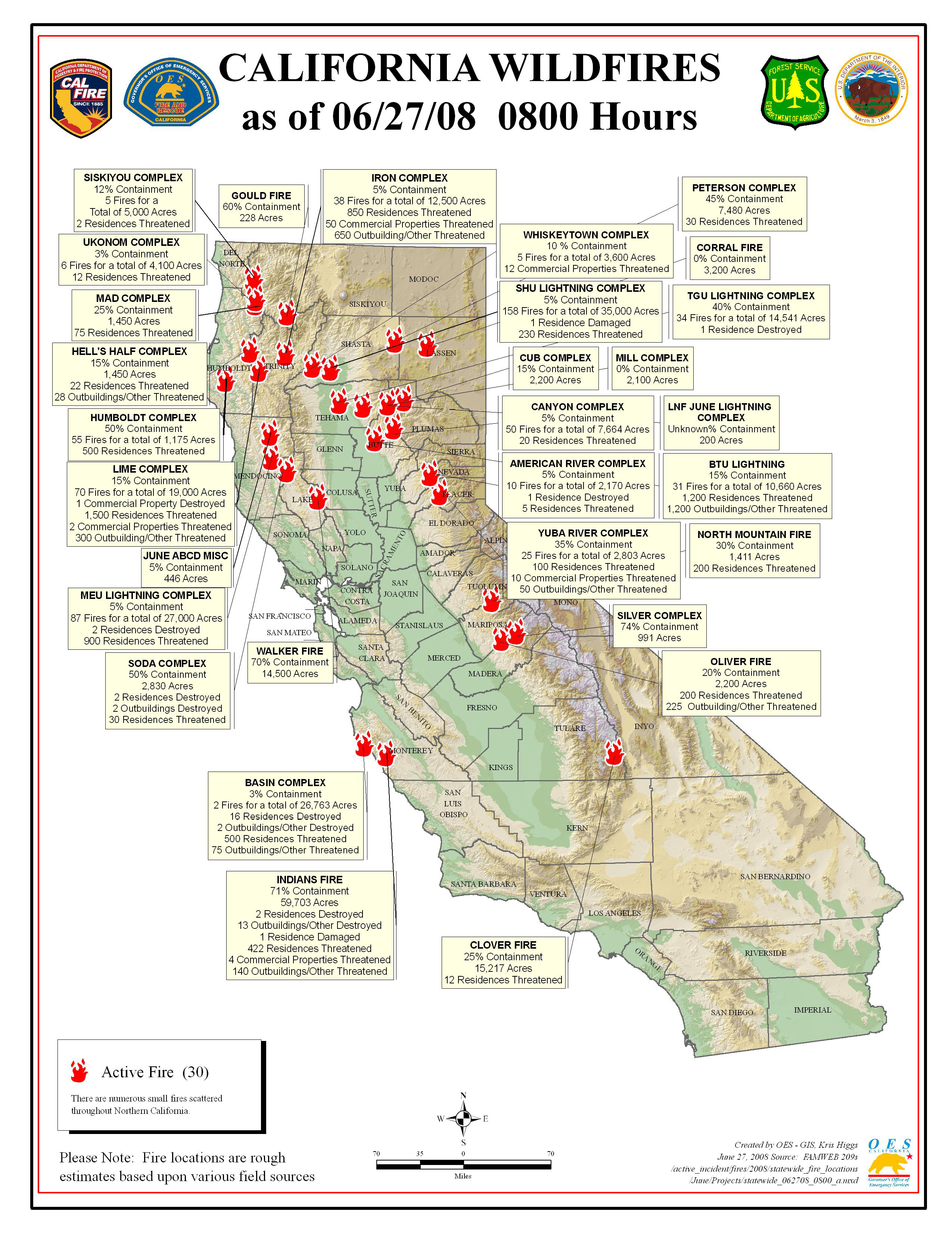
CA Fire Map Saturday 06/28 AM
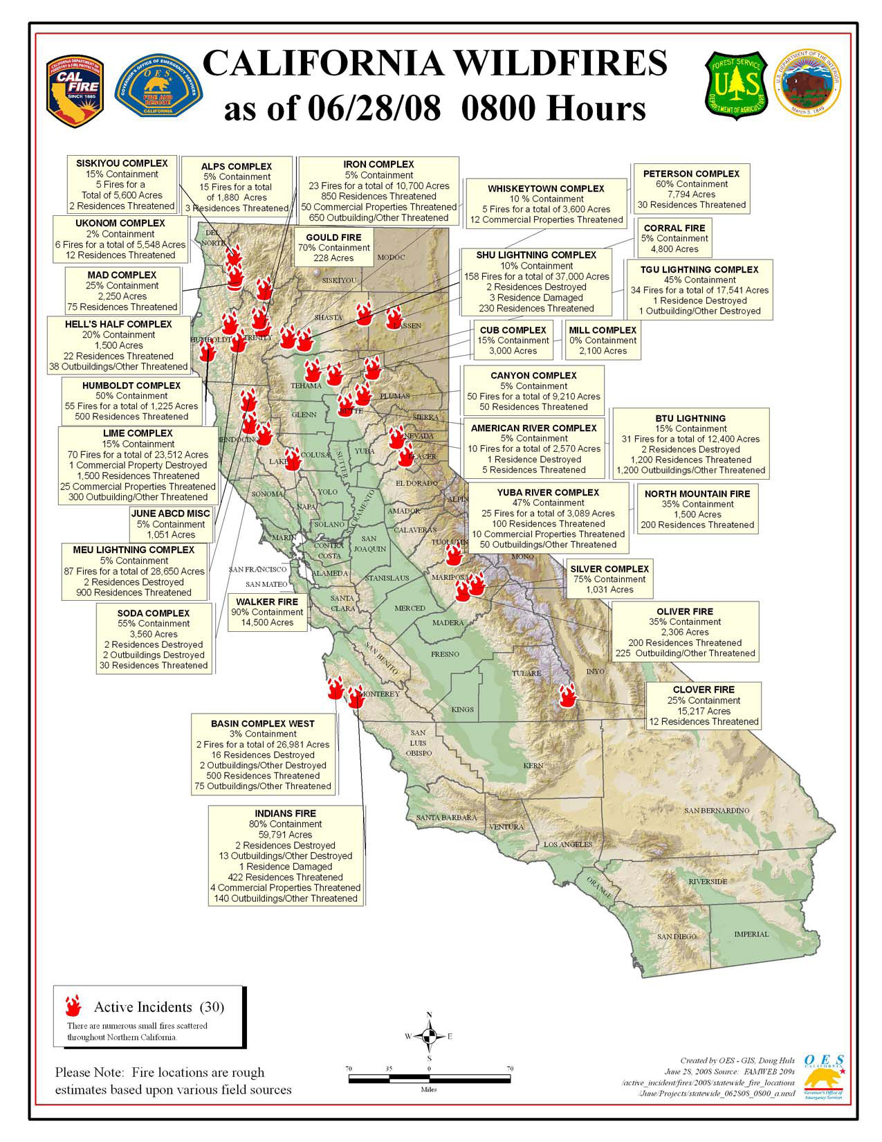
Click map for larger image (3.75 MB).
RED FLAG WARNING in effect from 1 pm this afternoon to 5 am PDT Monday for Northeast California for scattered dry thunderstorms. Low pressure off the California coast will produce an unstable air mass leading to development of isolated to scattered thunderstorms this weekend. Many storms today will produce little to no rainfall due to dry air above the surface. By Sunday more storms will become wetter but shorter rainfall duration is expected due to increased storm motion.
Western Nevada Sierra Front including a portion of the Humboldt Toiyabe NF 10:06 am PDT Sat Jun 28 2008: Winds upslope 3 to 7 mph becoming SE 6 to 12 mph in the afternoon. Ridge top NE winds 6 to 12 mph shifting to the SE in the afternoon. Partly cloudy with isolated thunderstorms through the night.
Total Fires: 1,345
Total Acres Burned: 308,893
Resources Committed
Personnel Committed: 17,264
Fire Engines: 1,194
Hand Crews: 451
Dozers: 296
Water Tenders: 351
Helicopters: 85
(These numbers are totals from state, local and federal firefighting agencies. Updated 6/28 at 9:00 a.m.)
Highway closures: State highways and local roads are closed throughout California due to wildfire activities. Closures and delays are in place for State Highways 1 (Big Sur Area), 32, 36, 70, 96 and 299. Numerous county and local roads are closed as well. Travelers are advised to seek current information from local law enforcement.
Evacuations: Areas of Butte, Mendocino, Monterey, Shasta, Tehama and Trinity counties are under evacuation orders at this time. Precautionary evacuation orders are in place for areas in Butte, Mariposa, Mendocino, Trinity and Shasta counties. Residents are advised to monitor the fire situation in their areas, check with local law enforcement agencies for information, and be prepared to evacuate when necessary.
Structures Destroyed: 28 residences, 1 commercial, 18 outbuildings.
Alps Complex WFU Fires
Location: 15 Fires all near or within Trinity Alps Wilderness on the Shasta Trinity NF, Trinity Co., CA
Date of Origin: 06/21/08
Cause: Lightning
Situation as of 07/11/08 6:00 PM
Total Personnel: 92
Size: 1,218 acres
Percent Contained: 80%
Costs to Date: $818,856
Alps Complex now a suppression fire. The last report for Alps Complex has been issued because it is being operationally merged into the Iron Complex [here]. We will attempt to sort it out and continue tracking the Alps Complex.
Granite 542ac 80% 7/22, Carey 567ac 30% 7/22, Rip 3ac 70% 7/15.
***************
Situation as of 07/09/08 5:30 PM
Total Personnel: 100
Size: 902 acres
Percent Contained: 80%
Costs to Date: $710,614
New smoke this morning west of the Granite Fire is called the Rip Fire and was jumped by 4 smokejumpers.
***************
Situation as of 07/08/08 11:00 PM
Total Personnel: 79?
Size: 816 acres
Percent Contained: 80%
Granite (530 acres, campground and trailhead, active fire, 80% contained, expected containment date, Jul 10, 2008), Carey (219 acres, active fire, 30% contained, expected containment date, Jul 22, 2008).
***************
Situation as of 07/07/08 4:45 PM
Total Personnel: 79
Size: 792 acres
Percent Contained: 75%
Costs to Date: $575,106
Est containment date: 07/25/2008. The Buckhorn Fire was taken over by the Broyles Type 1 IMT managing the Iron Complex. All the Alps Complex fires are slated for containment at the earliest possible date. The prior threat by the Shasta-Trinity NF to allow these fires to burn all summer has been wisely rescinded.
***************
Situation as of 07/05/08 5:15 PM
Total Personnel: 85
Size: 786 acres
Percent Contained: 30%
Costs to Date: $448,988
***************
Situation as of 07/04/08 4:40 PM
Total Personnel: 85
Size: 708 acres
Percent Contained: 15%
Costs to Date: $391,094
Acreage change due to transitioning of the Buckhorn Fire to the Iron Complex.
****************
Situation as of 07/03/08 11:00 PM
Total Personnel: 85?
Size: 3,993 acres
Percent Contained: 0%
Costs to Date: unreported
Expected containment date: 11/15/08
Burn baby burn. This fire represents long term employment for firefighters. No strategy to contain, control, or extinguish. Taxpayers expected to shovel money into the fire all summer long. No NEPA, no ESA, no NHPA, no compliance with any environmental law. Trinity Wilderness closed indefinitely. Mt. Shasta, Dunsmuir, will be smoky all summer long.
***************
Situation as of 07/02/08 5:00 PM
Total Personnel: 85
Size: 3,579 acres
Percent Contained: 5%
Costs to Date: $212,689
Long Term Implemenation Plan(LTIP) for all active fires means no containment, burning expected to go on until November rains.
Expected costs to exceed $10 million ($100,000 per day x 100 days), assuming no major fire blow ups between now and next Fall. Resource damage will be very significant to vegetation, wildlife, watersheds, and airsheds. Trinity Alps recreation canceled for the rest of the summer in all likelihood. No public hearings were or will be held.
All public comments should be directed to the individual responsible for this executive decision, Shasta-Trinity NF Supervisor Sharon Heywood, 3644 Avtech Parkway, Redding, CA 96002, (530) 226-2500.
A Fire Use Module and some overhead will hike into the Carey WFU Fire. No explanation regarding what “some overhead” might be, but chances are it is a mule train.
Buckhorn (1870 acres, 2 residences and 1 outbuilding threatened, active fire, 12% contained, expected containment date, Oct 17, 2008), Granite (431 acres, campground and trailhead, active fire, 24% contained, expected containment date, Oct 2, 2008), Clem (1024 acres, archaeological site, active fire, 0% contained, expected containment date, Nov 15, 2008), Carey (186 acres, 1 residence threatened, active fire, 0% contained, expected containment date, Nov 15, 2008), Soldier (2 acres, unstaffed expected containment date, Nov 15, 2008), Bacon (2 acres, unstaffed, expected containment date, Nov 15, 2008), Gorge (1 acre, unstaffed, trailhead and bridges, expected containment date, Nov 15, 2008), Gwin (7 acres, unstaffed, expected containment date, Nov 15, 2008), North Fork (8 acres, unstaffed, expected containment date, Nov 15, 2008).
***************
Situation as of 07/01/08 5:00 PM
Total Personnel: 39
Size: 3,245 acres
Percent Contained: 2%
Costs to Date: $116,689
The dozer line at Brooks Ranch is currently limiting the fires spread to the south. Last night’s slop over of the Buckhorn Fire to the west on French Creek Road was successfully picked up during today’s operational period. The Granite Fire continues to be held from moving west on the Canyon Creek trail. The draft of the Long Term Implementation Plan (LTIP) for the Alps Complex was presented to the Forest Supervisor and Area Command this afternoon.
***************
Situation as of 06/30/08 5:00 PM
Total Personnel: 31
Size: 2,650 acres
Percent Contained: 2%
Costs to Date: $100,242
The dozer line at Brooks Ranch which is currently limiting the fires spread to the south. Tentative completion of the Long Term Implementation Plan (LTIP) for the Alps Complex is 7/01/08. Sucessfully holding the Granite Fire from moving west on the Canyon Creek trail.
The complex includes 13 fires. Buckhorn (1409 acres, 2 residences and 1 outbuilding threatened, active fire), Granite (415 acres, campground and trailhead, active fire), Clem (687 acres, archaeological site, active fire), Carey (71 acres, 1 residence threatened, active fire), Soldier (2 acres, unstaffed), Bacon (2 acres, unstaffed), Gorge (1 acre, unstaffed, trailhead and bridges), Gwin (7 acres, unstaffed), North Fork (8 acres, unstaffed), Willow (38 acres, unstaffed), Devils (6 acres, contained), Pony (3 acres, contained), and Thurston (2 acres, contained).
***************
Situation as of 06/28/08 5:00 PM
Total Personnel: 18
Size: 2,445 acres
Percent Contained: 0%
The complex includes 15 fires. Currently 5 fires are known to be active. Buckhorn (915 acres), Clem (601 acres), Denny (20 acres), Carey (7 acres) and Granite (391). Buckhorn Fire has reached the dozer line at Brooks Ranch which is currently limiting the fires spread to the south.
Tentative completion of the Long Term Implementation Plan (LTIP) for the Alps Complex is 6/30/08.
***************
Situation as of 06/26/08 10:00 PM
Total Personnel: 18
Size: 1,800 acres
Percent Contained: 5%
Fire were previously reported as part of the Iron Complex Fires [here].
Smoke Screen
Pyramid Lake from the computer cam a day before the fires.
Same view, same computer cam, on Wednesday. Courtesy Eric Ingraham PLPT, Utility Operations, Pyramid Lake Paiute Tribe.