Skinner Fire (East Lake Fire)
Location: northeast side of Washoe Valley 15 miles south of Reno
Date of Origin: 04/29/2008 PM
Cause: powerline downed Tuesday afternoon by fierce winds
Situation as of 04/30/08
Total Personnel: 250
Size: 962 acres
Percent contained: 75 %
Full containment was expected by nightfall.
Summary: Though conditions remained breezy Wednesday, the wind was tame compared to the 70 mph gale-force winds Tuesday. The fire briefly forced the closure of U.S. 395, the main highway between Reno and Nevada’s capital, Carson City, during the evening rush hour. Students at an elementary school in nearby Pleasant Valley also were evacuated as a precaution.
Firefighters were able to keep the flames from four hillside homes, though a pump house and shed were burned. Five firefighters were treated at a local hospital for eye irritations caused by blowing ash and embers, officials said.
Tuesday’s strong winds grounded firefighting helicopters and airplanes. By Wednesday, the aerial equipment was not needed.
Info from KOLO TV [here].
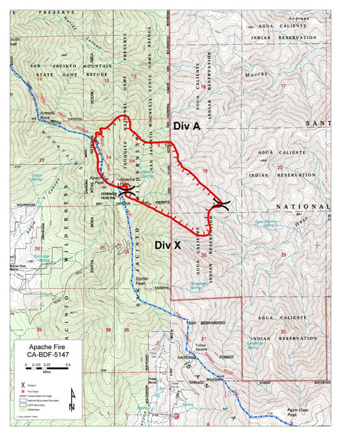
Apache Fire
Location: San Jacinto Wilderness, San Bernardino NF, Riverside County, CA
Specific location: Apache Peak near the Pacific Crest Trail, about six miles east of the Riverside County community of Mountain Center.
Date of Origin: 04/29/2008 at 1635 hrs.
Situation as of 05/04/08, 7:00 PM
Total Personnel: 328
Size: 784 acres
Percent contained: 100 %
The Apache Fire was declared 100 % contained this afternoon. Firefighting personnel are being pulled out. The PCT and the San Jacinto Wilderness are closed from Saddle Junction south to Highway 74, but that closure will probably be lifted sometime tomorrow.
***************
Situation as of 05/03/08
Total Personnel: 731
Size: 784 acres
Percent contained: 64 %
Estimated Containment Date 05/04/2008 at 1800 hrs.
Notice 05/03/08 AM: The San Jacinto Wilderness is open from Devil’s Slide Trail northward, includng the PCT. The PCT and the San Jacinto Wilderness are closed from Saddle Junction south to Highway 74 due to the fire. Mt. San Jacinto State Park is open. The Palm Springs Tramway and adjacent Long Valley are open.
***************
Situation as of 05/02/08
Total Personnel: 721
Size: 784 acres
Percent contained: 64 %
Estimated Containment Date 05/04/2008 at 1800 hrs.
***************
Situation as of 05/01/08 (updated)
Total Personnel: 711
Size: 784 acres
Percent contained: 25 %
Resources assigned include 30 handcrews, 2 helicopters, 2 helitankers, and 4 fixed wing aircraft.
***************
Situation as of 04/30/08
Total Personnel: 170
Size: 700 acres
Percent contained: 0 %
Fuels: Heavy brush, some timber, dead and down.
Fire Behavior: Rapid rates of spread.
Summary: Due to steep roadless terrain, 9 handcrews hiked into fire this morning. High winds, smoke and steep terrain have made accessing fire difficult. Aircraft were grounded due to high winds and a heavy marine layer limiting visibility this morning but have been flying this afternoon.
Growth Potential: Extreme.
Current Wind Conditions: 40 mph W
Current Temperature: 54 degrees
Current Humidity: 40 %
X Fire
Location: Tusayan Ranger District, Kaibab National Forest, Coconino Co. AZ
Specific Location: East side of state Highway 64 between Ten-X Campground and the southern boundary of Grand Canyon NP, about three miles southeast of Tusayan.
Date of Origin: 04/29/2008 at 1239 hrs.
Cause: Human-caused
Situation as of 05/02/08:
Total Personnel: 156
Size: 2,048 acres
Percent Contained: 80%
Additional Info: Three campers have been charged with criminal negligence for leaving their campfire unattended and inadvertently igniting the X Fire. See Comments below.
***************
Situation as of 04/30/08:
Total Personnel: 165
Size: 2,030 acres
Percent Contained: 60%
Fuels Involved: Ponderosa pine, grass and sage.
Fire Behavior: Spotting, torching, running. No structures have been lost.
Chanty Fire (Santa Anita Fire)
Where: City of Sierra Madre and Angeles National Forest (Los Angeles County)
Date of Origin: 04/26/2008 at 1500 hrs.
Chanty Fire declared contained 05/03/08 at 584 acres.
Situation as of 04/30/08:
Total Personnel: 923
Size: 584 acres
Percent Contained: 88%
Estimated Containment Date 05/02/2008 at 1800 hrs.
Except for the Chantry Flat area, evacuations have been lifted.
***************
Situation as of 04/28/08:
Total Personnel 699
Size 538 acres
Percent Contained 21%
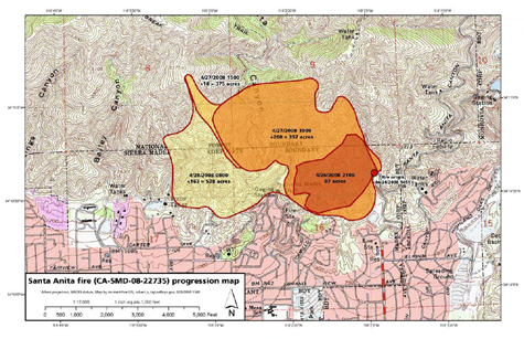
Map courtesy InciWeb
***************
Situation as of 04/27/08:
Total Personnel 900
Size 400 acres
Percent Contained 30%
Evacuations: Approximately 1,000 people have been evacuated from Oak Crest Drive across Carter Avenue to East Mira Monte Avenue, continuing down Mountain Trail Avenue, across Grandview Avenue to Santa Anita Avenue. Hikers, campers, and a wedding party were evacuated from Sturdevant’s Camp campground and taken to the Chantry Flats Ranger Station about a mile from the fire.
Fuels: Heavy brush, chaparral, and light timber.
Fire Behavior: Slow to moderate rate of spread. Fire is terrain-driven, burning uphill into the Angeles National Forest (San Gabriel Mtns).
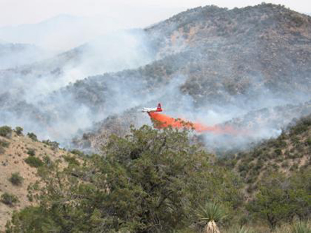
Alamo Fire
Where: Coronado NF, Cochise Co., Arizona
Specific Location: Pajarita Wilderness ~7 miles west of Peña Blanca Lake. No maps available at this time.
Date of Origin: 04/18/2008, AM
***************
Situation as of 04/30/08:
Alamo Fire
Total Personnel: Unknown
Size 5,072 acres
Percent Contained 95%
Beehive Fire
Total Personnel: Unknown
Size 325 acres
Percent Contained 80%
Estimated Containment Date 04/30/2008
All resources were pulled off the fire yesterday. Fire will be monitored by air.
***************
Situation as of 04/25/08:
Total Personnel 190
Size 5,072 acres
Percent Contained 85%
A second fire, the Beehive Fire which started early Wednesday afternoon has been declared a part of the Alamo Fire Complex. The Beehive Fire is 8 miles NNW of the Alamo Fire. It started near Murphy Peak on the Nogales Ranger District of the Coronado National Forest. It is approximately 5 miles east of Arivaca Lake in a very remote area of the forest. The fire is in Santa Cruz county near the border with Pima County.
The Beehive Fire was reported to be 300 acres Wednesday. It is being fought with air tankers and helicopters because of the remote location. It is not known whether any on-the-ground attempt is being made to line or contain the Beehive Fire, but indications are that there are none at this time.
No cost estimates of the Alamo Complex have been issued or posted at InciWeb. Maps and a video are available [here].
***************
Situation as of 04/22/08:
Total Personnel 350
Size 5,072 acres
Percent Contained 75%
High winds have moderated. Full containment expected Thursday.
***************
Situation as of 04/21/08:
Total Personnel 278
Size 5,072 acres
Percent Contained 30%
Eastern Arizona Type II IMT has assumed management of the fire.
Pena Blanke Lake has been evacuated.
Maps are available [here]
About 200 acres of the Alamo Fire are in Mexico. The U.S. Border Patrol and the Mexican government are being advised and kept informed by the IMT.
***************
Situation as of 04/20/08:
Total Personnel 170
Size 3,000 acres
Percent Contained 10%
Summary: Fire began in U.S. but now burning on both sides of the U.S./Mexico International Border. Fire crews are conducting burnout operations where the Peña Blanca and Alamo drainages meet near Ruby Road.
No homes destroyed. Two ranches threatened.
Evacuations: None at this time.
Cause: Assumed human — under investigation.
Firefighting resources: Two Arizona State Forestry hand crews, one hand crew composed of Northwest Fire and Coronado National Forest firefighters, one Navajo Scout crew, fire engines from Nogales and Rio Rico Fire Departments, a light helicopter and two heavy air tankers. Ten additional fire engines and a water tender have been ordered, as have two more twenty-person hand crews and two more helicopters. An order is pending for seven Hot Shot crews. The Eastern Arizona Type II IMT has been assigned and will assume management at 8:00 PM tonight.
Fuels are grasses, brush, and oak. Terrain steep. No fire roads.
Outlook: Winds of 40 mph are forecast.
Photo courtesy Inciweb [here]. Credit Mark South.
Fort Carson Fire
Where: Fort Carson, El Paso Co., Colorado
Date of Origin: 04/14/2008, time unknown
Situation as of 04/19/08:
Total Personnel ~300
Size 9,600 acres
Percent Contained 75%
Summary: One fatality. Pilot Gert Marais, 42, of Fort Benton, Mont., crashed his single-engine air tanker Tuesday evening. Marais crashed on his first slurry run of the day in high winds. See [here].
No homes were destroyed.
Evacuations: 800 people evacuated. Evacuation order lifted.
Cause: Unknown
Outlook: Heavy snow has apparently damped the fire. Mop up of hot spots continues today.
Ordway Fire
Where: Ordway, Crowley Co., Colorado
Date of Origin: 04/15/2008 at 1500 hrs
Situation as of 04/18/08:
Total Personnel ~300
Size 8,900 acres
Percent Contained 100%
Summary: Two firefighter fatalities. Fire Chief Terry DeVore and firefighter John Schwartz died Tuesday when their fire truck crossed a burned bridge and plunged into a ravine. See [here].
More than 24 homes were destroyed. Video [here]
Evacuations: 1,200 people evacuated. Evacuation order lifted.
Cause: two insufficiently extinguished controlled burns that rekindled. See [here].
Texas Fires Update
As of 04/18/08 there have been 149 wildfires in Texas this year, three of which are still active. Burned area totals 696,976 acres to date.
As of 04/23/08 there have been 153 wildfires in Texas this year, all contained. Burned area totals 698,411 acres to date.
As of 04/30/08 there have been 149 wildfires in Texas this year, three of which are still active. Burned area totals 700,437 Acres acres to date.
As of 05/03/08 there have been 147* wildfires in Texas this year, two of which are still active. Burned area totals 771,800* acres to date.
*Note: information based on InciWeb reportage. No specific info provided as to why the total fire count went down between 4/23 and 4/30, and again between 4/30 and 5/03. These are contained incidents. They either happened or they didn’t. The acreage totals are also suspect, and apparently lower than actual by ~30,000 acres.
Trigo Fire
Where: Cibola National Forest, Torrance Co., New Mexico
Specific Location: South of Capilla Peak
Date of Origin: 04/15/2008 at 1555 hrs
Situation as of 05/13/08
Total Personnel: ???
Size: 13,709 acres
Percent Contained: 100% on 05/11/08
Significant Events: Suppression rehab hould be completed by today. Management of the fire is being transferred to a Type 3 (local) IMT. On Monday the Trigo Fire was again tested with record low humidity and strong winds with gusts in excess of 40 mph. Late in the afternoon a small patch of unburned fuel well within the fire perimeter actively burned. This caused calls to the Information Center regarding fire activity. Immediate contact from Operations people in the field confirmed this was not a threat to the containment line.
Winds 5 to 10 mph becoming west 15 to 20 mph in the afternoon with gusts up to 30 mph. Weather mostly cloudy with isolated showers and thunderstorms in the evening, then isolated rain showers after midnight. Chance of precipitation 70 %.
Flash Flood Warning: Communities and homes downstream from the Trigo wildfire will be especially susceptible to flooding from this rain event. This includes the area found between the communities of Manzano and Torreon. Drainages of concern include New, Cuervo, Jaral and Torreon canyons.
***************
Situation as of 05/12/08
Total Personnel: 356
Size: 13,709 acres
Percent Contained: 100%
***************
Situation as of 05/08/08
Total Personnel: 667
Size: 13,709 acres
Percent Contained: 75%
Current Wind Conditions 32 mph W
Current Temperature 72 degrees
Current Humidity 12 %
***************
Situation as of 05/07/08
Total Personnel: 774
Size: 13,680 acres
Percent Contained: 60%
New Mexico remains on Red Flag Warning for strong winds.
FEMA began a preliminary damage assessment on Tuesday in the areas affected by the Trigo Fire. A federal declaration request had been made and accepted by FEMA prior to the blow up 04/30. At that time nine homes had been burned. The count is now ~60 homes destroyed by the Trigo Fire.
***************
Situation as of 05/06/08
Total Personnel: 806
Size: 13,680 acres
Percent Contained: 55%
The evacuation of the Sherwood Forest subdivision has been lifted by Torrance County Civil Authorities. Residents of Sherwood Forest can now enter the subdivision.
Returning residents should be alert for hazards such as concealed pockets of burning embers, burned trees that could fall and downed electric lines.
***************
Situation as of 05/05/08:
Total Personnel 809
Size: 13,680 acres
Percent Contained 50%
An official damage assessment is expected this afternoon.
***************
Situation as of 05/04/08:
Total Personnel 472+
Size 13,790 acres
Percent Contained 35 %
In addition to the 50 homes burned in the blow up, one communications tower (the easternmost facility) has been heavily damaged.
Trigo fire progession map [here] (courtesy InciWeb)
Current Wind Conditions: 10-20 mph NW
Current Temperature: 55 degrees
Current Humidity: 16 %
***************
Situation as of 05/03/08:
Total Personnel 472+
Size 13,790 acres
Percent Contained 35 %
Summary: Torrance County Sheriff’s Department will continue to assess damage today. Currently it appears less than one hundred homes were damaged. As there is active fire still in the area the threat for damage still remains. There is a strong law enforcement presence and no looting is occurring. [here]
Update 11:00 PM: KRQE TV is reporting that 50 homes were burned in the blow up of 05/01. See comments.
***************
Situation as of 05/02/08:
Total Personnel 472
Size 13,790 acres
Percent Contained 35 %
Summary: 600 families evacuated homes in the Torreon and Tajique area. Affected areas include Sufi Campground, Sherwood Forest, Apple Mountain Campground and Ten Pines Road. Residents were asked to evacuate to the Estancia Community Center at Williams Street in Estancia where the American Red Cross has set up.
More than a dozen homes burned yesterday, possibly twice that many. High winds of 30-40 mph with gusts up to 50 mph have made aerial firefighting all but impossible. Heavy smoke obscures views.
***************
BLOW UP !!!
The Trigo Fire has jumped containment lines and more than doubled to 11,360 acres.
Situation as of 05/01/08:
Total Personnel 182
Size 11,360 acres
Percent Contained ???
Cost to date: ???
Summary - Around 3 p.m. yesterday wind gusts up to 50 mph carried an ember approximately ½ mile North of the containment line. Winds were from the Southwest to the Northeast pushing the fire from the New Canyon area toward Capilla Peak and Forest Road 55 (Torreon and Tajique Loop Road).
A Type One team was ordered when the surrounding communities were determined to be in the path of the fire.
At 3:35 p.m. the Torrance County Emergency Office started evacuations in the area of Ten Pines Road, Sherwood Subdivision and later Torreon, SUFI Camp, and the FR 55 Loop Road were included. An Evacuation center is on stand-by at the Estancia Community Center and can be opened at a moments notice. Livestock is being accepted at Torrance County Fairgrounds.
Road closures are at West bound Hwy 55 at Junction 55 and Hwy 337 and Abshire Rd./Ewing Highway.
Two air tankers with a lead plane continued to drop retardant until dark. Firefighters were fighting the fire on the flanks.
The type 3 team will transition to a Type 1 Team (Whitney) today. Additional resources are on order. Torrance County Emergency Management will be holding a meeting today at 1pm in the Estancia Community Center.
Wind: 10-25 mph NW, with gusts to 55 mph
Current Temperature: 57 degrees
Current Humidity: 8-12 %
Estimated Containment Date: 12/29/2008 at hrs.
***************
Situation as of 04/26/08:
Total Personnel 478
Size 4,910 acres
Percent Contained 59%
Cost to date: $4,800,000
Reduced wind allowed firefighters to hold and extend lines Friday. Outlook is good for containment by Monday.
A community meeting is scheduled for this evening at 6:00 PM in the Torreon Community Center. Possible natural resource restorative measures for those affected by the fire will be discussed. The local chapter of the American Red Cross has provided a toll free number (1-800-560-2302) for those needing assistance whose homes were lost or damaged by the Trigo fire.
Congressional staffers, the Mayor of Mountainair and officials from Claunch Soil and Water Conservation District visited ICP today for a tour and briefing. New Canyon Road to Capilla Peak remains closed from the Forest boundary west. Red Canyon campground remains closed, and Forest Road 358 into Bartolo Canyon is blocked due to firefighter activity.
Beehive Fire (8 mi. N of the Trigo Fire and part of the Trigo Complex)
Situation as of 04/26/08:
Total Personnel 187
Size 325 acres
Percent Contained 40%
Three Type I (Hotshots) crews were transported to the fire via helicopter and one Type II crew transported off the fire. Resources are spiked out (camped onsite) and will continue to build line and secure perimeter.
***************
Situation as of 04/25/08:
Total Personnel 509
Size 4,910 acres
Percent Contained 53%
Cost to date: $4,500,000
A frontal passage yesterday evening brought a change in wind direction, from southwest to northwest, causing some concern along the southern flank but reducing the threat to the Capilla Peak Observatory north of the fire. Firefighters were battered by gusty winds yesterday as they continued to strengthen control lines. Strong, gusty winds prevented the use of air tankers, and only three bucket drops were made by a heavy helicopter before air operations were suspended.
The Trigo Fire is now under a unified command with New Mexico State Forestry.
***************
Situation as of 04/24/08:
Total Personnel 506
Size 4,600 acres
Percent Contained 46%
Cost to date: $3,800,000
Current Wind Conditions 28-35 mph SW
Current Temperature 78 degrees
Current Humidity 8 to 12 %
Today will be a critical day in maintaining control of the Trigo Fire. Extreme wind conditions are expected between 11:00 a.m. and 8:00 p.m., with gusts up to 40 miles per hour.
The fire is moving north up Capilla Peak. The east and west extremities of the fire have cooled down and rehabilitation efforts are underway in those areas. The area below Capilla Peak however, continues to provide resistance.
The University of New Mexico’s Capilla Peak Observatory is threatened.
Aircraft will fly today as wind conditions permit, dropping retardant and water as needed.
***************
Situation as of 04/23/08:
Total Personnel 524
Size 4,425 acres
Percent Contained 36%
Cost to date: $3,200,000
Air tankers dropped 82,000 gallons of retardant on hotspots Tuesday, while heavy helicopters dowsed flames with about 40,000 gallons of water. Tankers and helicopters will continue to make drops today. The Belen Alexander Municipal Airport is being used as a helibase. Type I heavy helicopters are dipping water from Manzano Lake.
Winds still strong, 28-33 mph W
Fuels: Pinyon-juniper; gamel oak; ponderosa pine and mixed conifer.
Evacuation orders were lifted Tuesday for Torreon and Manzano, although residents should remain on alert in case the fire changes directions. The New Canyon area remains closed at this time. National Interagency Coordination Center reports 20 structures lost.
New Mexico Gov. Bill Richardson toured the fire yesterday. Friday he will meet with Venezuelan President Hugo Chavez this week to discuss three American hostages being held by rebel forces in Colombia.
***************
Situation as of 04/22/08:
Total Personnel 389
Size 4,130 acres
Percent Contained 27%
High winds have moderated. Torrance County’s emergency management director lifted voluntary evacuations Tuesday morning for Torreon and Manzano.
About 14,000 tons of fire retardant were dropped on the blaze Monday, while helicopters dumped water on hot spots. A flare-up occurred on the western side of the fire in Valencia County near Meadowlake at around 2 p.m. Monday.
Fire crews from Sun City, Surprise, Peoria, and Mesa fire departments are assisting, as well as firefighters from the Phoenix area.
Officials estimate the cost of fighting the blaze at $2,300,000 to date. The Federal Emergency Management Agency has approved New Mexico’s request to help pay for state and local efforts to fight the Trigo fire. The FEMA Fire Management Assistance Grant covers 75 % of eligible firefighting costs, while local governments pay for 25 percent.
***************
Situation as of 04/21/08:
Total Personnel 387
Size 3,745 acres
Percent Contained 10%
Evacuation Notice: At 3:00 PM yesterday the residents of Manzano and Torreon were ordered to evacuate by the Torrance County Office of Emergency Services.
Winds are SW 30 mpg and the fire is moving NE. The fire traveled three miles within five hours, producing flame lengths of 100 - 200 feet. A convection column sent embers a half mile or more beyond the fire front.
Wind-driven flames jumped a fire contingency line and crossed the Cibola National Forest boundary onto private land Sunday, roaring onto flatter land with grass and shrubs.As of 6:00 PM today nine homes, nine outbuildings and two recreational vehicles have been reported burned. Hundreds of homes in and near Manzano are reported threatened. No personal injuries have been reported.
The University of New Mexico’s Capilla Peak Observatory is also threatened.
Officials estimate the cost of fighting the blaze to date at $1,870,000.
***************
Situation as of 04/20/08:
Total Personnel 335
Size 1,320 acres
Percent Contained 30%
***************
Update 04/20/08: 20 mph winds gusting to 35 mph are making containment difficult.
Crews attempted to deepen the black line between the fire front and the northern perimeter of the fire by consuming unburned fuel with drip torches. However, single digit humidity and strong south winds forced suspension of the effort about midday. Conditions caused some interior runs and spotting over containment lines, but all spots were quickly corralled or extinguished with retardant. Air tankers and helicopters dropped 65,000 gallons of retardant on hot spots and in front of flame fronts. - InciWeb report 6:00 AM 4/20/08
A public meeting was held in Torreon, NM yesterday with ~80 residents in attendance. Manzano and Torreon residents remain on standby for possible evacuations.
**************
Situation as of 04/18/08:
Total Personnel 335
Size 1,160 acres
Percent Contained 30%
Estimated Containment Date 04/24/2008
Summary as of 04/18/08: Steep, rugged terrain and canyon winds continue to challenge containment efforts on the Trigo Fire. The fire made an active run to the East side of Osha Peak Wednesday night due to high winds from the passage of a cold front.
Cloudy conditions, cool temperatures and higher relative humidity aided firefighters in the containment effort yesterday. Air tankers and helicopters continued to be used as wind conditions allowed.
As the fire continues to grow, Cowie’s Type II Team and district fire personnel have developed strategies actively working contingency lines between the head of the fire and the local communities. The next two days will be important in the direction of this fire and suppression effort.
Evacuations: There are currently NO community evacuations; however, east Manzano residents are asked to be prepared in case the need for evacuations arises. Have personal items such as important papers, prescriptions and pictures packed and ready to go in case there is a need for evacuation.
Area residents are urged to be aware of increased fire traffic on highway 47 southeast of Belen, highway 60 from the highway 47 junction to Mountainair, Forest Road 33 (access to the closed JFK Campground).
Closures: Forest Road 245 to Capilla Peak and Red Canyon Campground are closed until further notice.
Basic Information:
Incident Type Wildland Fire
Cause Under Investigation
New Mexico Type II IMT assigned, IC Craig Cowie
Outlook: Planned Actions Continue constructing fireline and burnout areas if possible. Continue to construct contingency line w/dozers on East flank for protection of the communities on the east side of Manzano Mtns. Continue to reduce fuels and provide structure protection surrounding the radio/communication towers.
Projected Movement Wind driven to the NE
Growth Potential High
Terrain Difficulty Extreme
Remarks Increase of 360 acres due to last night’s IR mapping, no growth in fire perimiter occurred today. Smoke Data: 80 acres of FM10 (20 tons per acre), 40 acres of FM19 (15 tons per acre), 140 acres of FM5(7 tons per acre).
No maps available at this time. See GEOMAC Viewer [here], Trigo Fire
Fire progression:
04/16 __ 400 acs
04/17 __ 650
04/18 __ 800
04/19 __ 1,160
04/20 __ 1,320
04/21 __ 3,750
04/22 __ 4,130
04/23 __ 4,425
04/24 __ 4,600
04/25 __ 4,910
05/01 __ 11,700
05/02 __ 13,790
05/04 __ 13,790
05/05 __ 13,680 (adjusted)
05/08 __ 13,709 (readjusted)
