Alamo Fire
Where: Coronado NF, Cochise Co., Arizona
Specific Location: Pajarita Wilderness ~7 miles west of Peña Blanca Lake. No maps available at this time.
Date of Origin: 04/18/2008, AM
***************
Situation as of 04/30/08:
Alamo Fire
Total Personnel: Unknown
Size 5,072 acres
Percent Contained 95%
Beehive Fire
Total Personnel: Unknown
Size 325 acres
Percent Contained 80%
Estimated Containment Date 04/30/2008
All resources were pulled off the fire yesterday. Fire will be monitored by air.
***************
Situation as of 04/25/08:
Total Personnel 190
Size 5,072 acres
Percent Contained 85%
A second fire, the Beehive Fire which started early Wednesday afternoon has been declared a part of the Alamo Fire Complex. The Beehive Fire is 8 miles NNW of the Alamo Fire. It started near Murphy Peak on the Nogales Ranger District of the Coronado National Forest. It is approximately 5 miles east of Arivaca Lake in a very remote area of the forest. The fire is in Santa Cruz county near the border with Pima County.
The Beehive Fire was reported to be 300 acres Wednesday. It is being fought with air tankers and helicopters because of the remote location. It is not known whether any on-the-ground attempt is being made to line or contain the Beehive Fire, but indications are that there are none at this time.
No cost estimates of the Alamo Complex have been issued or posted at InciWeb. Maps and a video are available [here].
***************
Situation as of 04/22/08:
Total Personnel 350
Size 5,072 acres
Percent Contained 75%
High winds have moderated. Full containment expected Thursday.
***************
Situation as of 04/21/08:
Total Personnel 278
Size 5,072 acres
Percent Contained 30%
Eastern Arizona Type II IMT has assumed management of the fire.
Pena Blanke Lake has been evacuated.
Maps are available [here]
About 200 acres of the Alamo Fire are in Mexico. The U.S. Border Patrol and the Mexican government are being advised and kept informed by the IMT.
***************
Situation as of 04/20/08:
Total Personnel 170
Size 3,000 acres
Percent Contained 10%
Summary: Fire began in U.S. but now burning on both sides of the U.S./Mexico International Border. Fire crews are conducting burnout operations where the Peña Blanca and Alamo drainages meet near Ruby Road.
No homes destroyed. Two ranches threatened.
Evacuations: None at this time.
Cause: Assumed human — under investigation.
Firefighting resources: Two Arizona State Forestry hand crews, one hand crew composed of Northwest Fire and Coronado National Forest firefighters, one Navajo Scout crew, fire engines from Nogales and Rio Rico Fire Departments, a light helicopter and two heavy air tankers. Ten additional fire engines and a water tender have been ordered, as have two more twenty-person hand crews and two more helicopters. An order is pending for seven Hot Shot crews. The Eastern Arizona Type II IMT has been assigned and will assume management at 8:00 PM tonight.
Fuels are grasses, brush, and oak. Terrain steep. No fire roads.
Outlook: Winds of 40 mph are forecast.
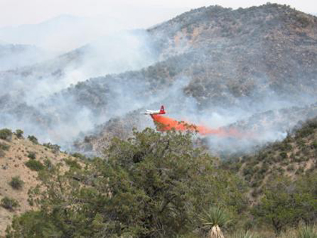
Photo courtesy Inciweb [here]. Credit Mark South.