Rooster Rock Fire
Location: 6 mi S of Sisters, Deschutes Co. OR
Specific Location: Three Creek Road, Deschutes NF, Lat 44° 13´ 10″ Lon 121° 35´ 4″
Date of Origin: 08/02/2010
Cause: Under investigation
Situation as of 08/09/2010 7:00 pm
Personnel: 451
Size: 6,134 acres
Percent Contained: 100%
Costs to Date: $5,333,872
Transfer of command to a type 3 organization is planned for 08/10/2010 0600.
***************
Situation as of 08/07/2010 7:00 pm
Personnel: 800
Size: 6,134 acres
Percent Contained: 65%
Costs to Date: $4,210,930
The Evacuation order has been lowered to level 1 evacuation. The road closure has been lifted. Smoldering, creeping with heavy fuels continuing to burn.
***************
Situation as of 08/06/2010 5:00 pm
Personnel: 986
Size: 6,134 acres
Percent Contained: 50%
Costs to Date: $3,605,627
The fire perimeter has remained the same over the last 24 hours. All control lines are plumbed with significant mop up occurring on north half of fire. The south side of fire is entering mop up stage. The evacuation level order is likely to be lifted in the morning.
***************
Situation as of 08/05/2010 5:00 pm
Personnel: 975
Size: 6,000 acres
Percent Contained: 40%
Costs to Date: $2,858,000
Burnout of interior islands. Hold and improve line, complete burnouts, patrol, and mop up.
***************
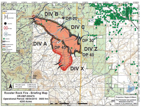
Situation as of 08/04/2010 7:00 pm
Personnel: 712
Size: 5,500 acres
Percent Contained: 30%
Costs to Date: $1,829,652
Structures Threatened: 50 PRIM
Structures Destroyed: 1 OUTB
Prolific short range spotting. Numerous spot fires are burning together. Direct attack with handtools is proving ineffective. Aircraft operations are limited by smoke. Today 40% chance of thunderstorms with gusts up to 40 mph.
***************
Situation as of 08/03/2010 7:00 pm
Personnel: 325
Size: 2,600 acres
Percent Contained: 20%
Costs to Date: $765,000
Structures Threatened: 50 PRIM
Structures Destroyed: 1 OUTB
Central Oregon Type 2 Interagency Incident Management Team [the CO2's] assumed command of this incident at 1000hrs. ICP established at Sisters Middle School, Sisters, Oregon.
Four homes remain evacuated. Areas spotted out in Divisions A and Z.
Major spotting during the afternoon drove the fire’s spread to the south. Short duration crowning, prolific spotting to the south up to 1/4 mile.
***************
Situation as of 08/02/2010 5:00 pm
Personnel: 180 - 300
Size: 1,000 - 2,000 acres
Percent Contained: 5%
70′-80′ flame lengths, spotting. Type 2 IMT requested. Early acreage reports not very accurate.
Update: Central Oregon Type 2 IMT deployed this morning (08/03). Evacuations underway in Plainview area off Hwy 20
Update 08/03 at 12:15 pm: The Rooster Rock Fire burning south of Sisters is now estimated to be 2,650 acres and about 5 percent contained, according to Central Oregon Interagency Dispatch.
Cowiche Mill Fire
Location: ~3 mi W of Yakima, Yakima Co. WA
Specific Location: Cowiche Creek, ~Lat 40° 39´ 00″ ~Lon 120° 45´ 00″
Date of Origin: 07/18/2010
Cause: Under investigation
Situation as of 07/19/2010 10:00 pm
Personnel: 250 to 300
Size: 6,200 acres
Percent Contained: 35%
Fire size reduction due to more accurate mapping. The fire destroyed or heavily damaged two homes and several outbuildings. Now smoldering.
***************
Situation as of 07/19/2010 9:00 am
Personnel: not reported
Size: 10,000+ acres
Percent Contained: 0%
5 alarm Wildland Fire Incident. Cowiche Mill Road. 10,000+ acres, multiple structures lost. Dozens of homes threatened. Ongoing Evacuations in place. Extreme rates of spread.
Fed, state, private resources are now being ordered up now from Western Washington. Fire District, DNR responding.
Gird End Foofurb* Fire
Location: 10 Miles E of Hamilton, Ravalli Co., MT
Specific Location: Bitterroot NF, Lat 46° 14´ 48″, Lon 113° 53´ 14″
Date of Origin: 09/09/2009
Cause: lightning
Situation as of 09/28/2009 6:00 pm
Personnel: 6
Size: 1,200 acres
Percent Contained: 0%
MMA: not reported
Monitor backing of fire to east toward State Highway. Possible trail closures and restricted highway travel.
*foofurb: euphemism for “fire used for resource benefit.” However, as is usual with foofurbs, no benefits have been elucidated, no EIS created, no public involvement or hearings held.
Cougar Ridge Fire
Location: 12 miles S of Wallowa, Wallowa Co., OR
Specific Location: Wallowa-Whitman NF, Big Sheep Ridge, Minam River watershed, Lat 45° 24´ 53″ Long 117° 35´ 20″
Date of Origin: 08/04/2009
Cause: Lightning
Situation as of 08/12/2009 3:00 pm
Personnel: 108
Size: 222 acres
Percent contained: 90%
Costs to Date: $1,260,659
Incident will be turned over to local unit 8/13.
***************
Situation as of 08/11/2009 9:00 am
Personnel: 156
Size: 421 acres
Percent contained: 80%
The main Cougar Fire area is approximately 222 acres, but adjacent spotting is heavy, so the total area affected by the fire is roughly 400 acres in size. The Meadow Mountain fire is 21 acres in size. Persistent rains on 8/6 slowed fire spread and also suppression activities. Plans call for lining and mopping up Cougar Ridge and Meadow Mountain fires.
***************
Situation as of 08/09/2009 7:00 pm
Personnel: 115
Size: 421 acres
Percent contained: 80%
***************
Situation as of 08/08/2009 9:00 pm
Personnel: 179
Size: 400 acres
Percent contained: 80%
Costs to Date: $576,922
Cold trailed and hot spotted the eastern perimeter of the fire. Persistent showers occurred over the fire yesterday.
***************
Situation as of 08/06/2009 6:00 pm
Personnel: not reported
Size: 400 acres
Percent contained: 0%
Central OR type 2 IMT (Rapp) engaged.
Trailer 1 Fire
Location: California-Nevada border on Seven Lakes Mountain, ~30 miles N of Reno, Washoe Co. NV
Specific Location: E of U.S. Highway 395 near the north end of Red Rock Road, Lat 39° 54´ 36″, Lon 120° 00´ 43″
Date of Origin: 07/15/2009
Cause: Human, vehicle sparks
Situation as of 07/22/2009 5:00 pm
Personnel: 12
Size: 1,349 acres
Percent Contained: 100%
Costs to Date: $925,000
***************
Situation as of 07/20/2009 5:00 pm
Personnel: 56
Size: 1,349 acres
Percent Contained: 95%
Costs to Date: $915,154
Minimal fire. Transition to local team today.
***************
Situation as of 07/20/2009 9:30 am
Personnel: ~150*
Size: 1,349 acres
Percent Contained: 95%
*Combined Trailer 1 and Red Rock Fire personnel: 478
***************
Situation as of 07/18/2009 5:00 pm
Personnel: 161
Size: 1,349 acres
Percent Contained: 80%
Costs to Date: $485,997
***************
Situation as of 07/17/2009 6:30 pm
Personnel: 250
Size: 1,336 acres
Percent Contained: 50%
Estimated Containment Date: Sunday July 19th
***************
Situation as of 07/16/2009 6:00 pm
Personnel: ~300
Size: 1,198 acres
Percent Contained: 20%
There are 6-7 residences in the fire area, about 2-3 miles outside of the fire perimeter. Monitoring continues to establish structure protection as needed.
Mike Whalen’s Type II Incident Management Team will take over this fire at 0600 on 7/17.
This northern flank of this fire has run into an old burn area, slowing the progression of the blaze. Firefighters will continue constructing direct fire line along the flanks of the fire.
Aircraft are being used to cool the fire ahead of the handcrews.
Hwy-395 and Red Rock Road are both currently open with no controls. Travelers are requested to watch out for fire apparatus and vehicles in and around the fire area.
Forrest Fire
Location: 30 miles W of Yakima, Yakima Co. WA
Specific Location: Ahtanum State Forest, Green Lake, Lat 46° 32′ 52″, Lon 121° 9′ 7″
Date of Origin: 07/11/2009
Cause: Lightning
Situation as of 07/15/2009 7:00 am
Personnel: 230
Size: 255 acres
Percent Contained: 100%
***************
Situation as of 07/13/2009 5:15 pm
Personnel: 342
Size: 255 acres
Percent Contained: 75%
Acreage reduction due to improved detection, mapping.
The fire is burning in bug-killed timber, creating a significant safety hazard. The concern is for firefighters working around snags and the high likelihood of trees falling unexpectedly.
***************
Situation as of 07/12/2009 6:00 pm
Personnel: 186
Size: 300 acres
Percent Contained: 50%
Rapid deployment, aggressive suppression actions by Washington IMT 1 (Johnson) credited.
Loma del Norte Fire
Location: 8 Miles S of Alpine, Brewster Co. TX
Specific Location: Lat: 30° 13´ 24″ Lon: 103° 32´ 6″
Date of Origin: 03/03/2009
Cause: Under investigation
Situation as of 03/05/2009 6:00pm
Personnel: 35
Size: 800 acres:
Percent Contained: 50%
Over 35 homes plus surrounding outbuildings have been saved with no losses or reported damage to any homes or structures. The burn out operation around various structures was successful, providing protection and securing black lines around the structures.
Very dry fuels and high winds continue to fuel interior burning. Aggressive suppression activities have subdued much of the fire that was of an immediate threat.
***************
Situation as of 03/04/2009 6:00pm
Personnel: 35
Size: 800 acres:
Percent Contained: 50%
At least 25 primary residences have been saved by aggressive suppression actions. Highway 118 remained open. Significant progress has been made due to the aggressive use of ground forces and aircraft.
Active fire fueled by high winds, dry fuels and uneven terrain with limited access will continue to contribute to very high fire behavior.
***************
Situation as of 03/03/2009 6:00pm
Personnel: 35
Size: 600 acres:
Percent Contained: 30%
This fire is burning eight miles south of Alpine in heavy juniper. Approximately 100 residences and 50 outbuildings in and near the Double Diamond Subdivision were saved. Two heavy airtankers and two single-engine airtankers dropped retardant yesterday and have been requested for additional drops this morning. A Type I interagency hot shot crew is on order to help with line construction and hot spots. The fire is 600 acres and 30 percent contained. A FEMA Management Assistance Grant (FMAG) was received for this fire.
