Bighorn Fire
Location: ~10 miles north of Upland, San Bernadino Co./Los Angeles Co., CA
Specific Location: Bear Canyon north of the Mt. Baldy Village area within the Angeles National Forest.
Date of Origin 05/13/2008 at 0430 hrs.
Cause Under Investigation
Situation as of 05/19/08
Total Personnel:
Size: 490 acres
Percent Contained: 100%
Costs to Date: $2,688,708
***************
Situation as of 05/18/08
Total Personnel: 289
Size: 490 acres
Percent Contained: 86%
Increase in fire acreage was due to improved mapping; fire is not growing. Demobilization tomorrow, with additional mop-up of hot spots identified with IR flights tonight.
***************
Situation as of 05/16/08 (eve.)
Total Personnel: 388
Size: 461 acres
Percent Contained: 72%
Estimated Containment Date 05/18/2008 at 1800 hrs.
De-mobilization underway
***************
Situation as of 05/16/08
Total Personnel 755
Size 420 acres
Percent Contained 60%
Estimated Containment Date 05/18/2008 at hrs.
Fire Behavior Fire activity remained minimal and was limited to roll out and short runs back into the black.
InciWeb Remarks: Increase in fire size due in part to fire growth (30%) and better mapping (70%)
W.I.S.E. Fire Tracking Remarks: We were the first and only outlet to report the 340 acre figure 36 hours ago. That was because we dot-gridded the map and calculated our own acreage. We posted 340 when everyone else was saying 300 or 320. We know how to measure maps.
Latest map from Inciweb:
***************
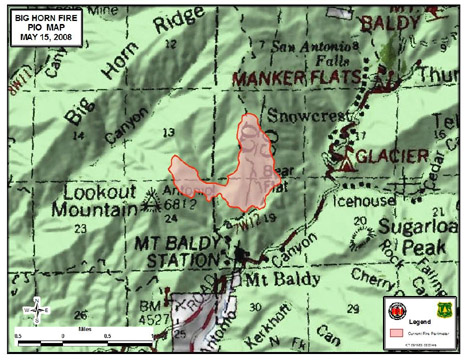
Situation as of 05/15/08
Total Personnel: 668
Size: 340 acres
Percent Contained: 25%
Fuels Involved: Brush with dry grass understory. The area, part of the Angeles National Forest, has not burned since 1975.
Weather outlook: Warm temperatures (near 100 degrees in the valley), very low RH, and strong N-NE winds gusting 30 to 45 mph. This weather pattern could effect the fire’s spread and push it to the southwest. This spread would threaten more homes and establish the fire in more continuous fuels.
Two airtankers and 5+ water-dropping helicopters flew yesterday. Minimal fire behavior was observed through the night. Some crews spiking (camping) near the fire.
***************
Situation as of 05/14/08
Total Personnel: 396
Size: 340 acres
Percent Contained 10%
At 6:00 a.m. today (Wed., May 14), command of the fire was transferred to Southern California Type II IMT (Joseph). Five helicopters were brought in to fight the fire and four are on the scene today. Flame-retardant-dropping planes were unable to fly because of the high winds Tuesday.
Current Wind Conditions: 7 mph S
Current Temperature: 53 degrees
Current Humidity: 33 %
Outlook: Winds N 10 to 15 mph. Gusts up to 30 mph.
***************
Situation as of 05/13/08
Total Personnel: 250
Size: 300 acres
Containment: 0%
Summary: Approximately 6 recreation residences in the vicinity of Bear Canyon have been evacuated. Fire came within about 100 yards of 30 to 40 cabins that were mostly unoccupied, fire officials said. None had been damaged by late afternoon. Mt. Baldy Road at Shinn is closed to the public and open to residents only. Glendora Ridge Road is closed at Mt. Baldy Road and is closed at the east fork. Winds up to 60 mph pushed flames this afternoon. State, federal, and county fire fighting resources resources are responding.
Map courtesy InciWeb, updated 05/13/08
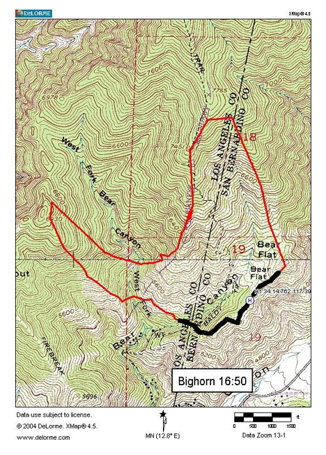
Photo courtesy Luis Sinco / Los Angeles Times

