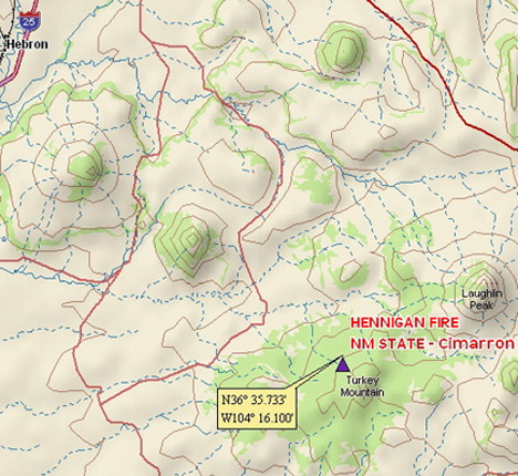
Hennigan Fire
Location: 22 miles SE of Raton, Colfax Co. NM
Specific Location: on the Hennigan Ranch, N slope of Turkey Mtn., SW of Laughlin Peak
Date of Origin: 05/24/2008
Cause: lightning
Situation as of 05/29/08
Total Personnel: 141
Size: 1,800 acres
Percent Contained: 80%
Costs to date: $700,000
***************
Situation as of 05/28/08
Total Personnel: 150
Size: 1,800 acres
Percent Contained: 60%
Costs to date: $550,000
Acreage increase due to backburning. Expected containment 05/29/2008
***************
Situation as of 05/27/08
Total Personnel: 150
Size: 1,200 acres
Percent Contained: 40%
Costs to date: $235,827
Expected Containment: 05/27/08
Summit Fire
Location: 10 miles west of Morgan Hill, 7 miles S of Los Gatos, Santa Cruz Co., Santa Clara Co., CA
Specific Location: Eureka Canyon in the Santa Cruz Mountains, near the intersection of Summit and Loma Prieta Roads, Ormsby Road, Eureka Canyon Road
Date of Origin: 05/22/2008, reported ~5:30 a.m.
Cause: human-caused
Situation as of 06/09/08
Total Personnel: 118
Size: 4,270 acres
Percent Contained: 100%
Costs to Date: $19,300,000
Structures Destroyed: 64 outbuildings , 35 homes
Mop up and patrol continued with emphasis on locating the hot spots identified during last night’s IR flight. Stump holes, dozer piles and large fuels (mainly in draws) are still being found smoldering within containment lines.
***************
Situation as of 05/28/08 6:00 PM
Total Personnel: 1,330
Size: 4,270 acres
Percent Contained: 100%
Costs to Date: $13,400,000
Observed Fire Behavior: Smoldering heavy fuels in the fire interior with no flaming front.
Demobilization of resources continued today. A damage assessment flight found additional structural damage today. Ground assessment teams are determining the extent of that damage. The incident will transition to the local unit on 5/30/08.
***************
Situation as of 05/27/08 6:00 PM
Total Personnel: 2,519
Size: 4,270 acres
Percent Contained: 100%
Costs to Date: $12,220,000
Full containment achieved today. Burning continues in the interior. Control (minimal flames and flame lengths) expected by Friday, when transition to local fire units is also planned. All road closures and evacuations were lifted today.
Structures Destroyed: 63 outbuildings , 31 primary residences (homes). Updated totals of structures destroyed resulted from completion of damage inspection.
An unknown number of firefighters are suffering from severe poison oak exposure.
***************
Situation as of 05/27/08 AM
Total Personnel: 2,631
Size: 4,270 acres
Percent Contained: 85%
Costs to date: $11,200,000
Fire managers are hoping for full containment Tuesday evening followed by full control Friday.
***************
Situation as of 05/26/08 6:00 PM
Total Personnel: 2,631
Size: 4,270 acres
Percent Contained: 80%
Latest damage assessment: 36 primary residences, 18 outbuildings destroyed. Acreage increase due to backfiring last night.
Costs to Date: $10,650,000
Demobilization of Type 1 engines and bulldozers today. Slow upslope spread toward Summit Road as fire transitioned into brush vegetation. Increase in activity in the interior of the fire due to change in weather pattern, otherwise no significant fire behavior observed. Continue mop-up and patrol tonight, holding and improving fire lines.
***************
Situation as of 05/26/08 8:00 AM
Total Personnel: 2,953
Size: 3,970 acres
Percent Contained: 70%
***************
Situation as of 05/25/08 8:00 AM
Total Personnel: 2,886
Size: 3,870 acres
Percent Contained: 50%
Cost to date: $6,100,000
Evacuations remain in effect. Control problems include establishing line in steep terrain and heavy, thick dead fuels. The fire made short runs during the night. No significant fire expansion.
In the Summit Fire area, skies will continue to be mostly cloudy today with scattered showers expected in the area. There is about a 30% chance of showers over the fire. Winds in the area will be quite light, a bit variable and easterly this morning, then likely becoming SW this afternoon from 2-10 mph and gusty.
***************
Situation as of 05/24/08 8:00 AM
Total Personnel: 3,004
Size: 3,400 acres
Percent Contained: 25%
New evacuations overnight for the Santa Clara Co. communities of Sveadal and residents of McPhee Road. Control problems include establishing line in steep terrain and heavy, thick dead fuels.
Fire under the management of Cal Fire Type 1 IMT (Waterman), with 94 crews, 289 engines, 13 helicopters, 2 air tankers.
Reported 17 homes and 11 commercial structures destroyed by the Summit Fire.
***************
Situation as of 05/23/08 6:00 AM
Total Personnel: 1,200
Size: 3,100 acres
Percent Contained: 20%
The communities of Croy, Uvas, Summit, and Corralitos are threatened. Evacuations and road closures are in effect. 500 residential, 20 commercial structures threatened.
Winds mild, 2 to 4 mph. Ocean fog cooling, damping the fire.
***************
Situation as of 05/22/08 9:00 PM
Total Personnel: 900+
Size: 3,000+ acres
Percent Contained: unknown
More than 20 homes have burned. Fire headed southwesterly toward Corralitos and Watsonville. Mandatory evacutation orders for Buzzard Lagoon, Vaca del Sol, Lower Highland Road, Ormsby and Mount Madonna roads, as well as Brown’s Valley and Apple Valley.
Firefighters were unsuccessful at holding the fire at Eureka Canyon. The fire now heading into Buzzard’s Lagoon and toward Nicene State Park.
Fire has been crowning in 80-to-100-feet-tall trees including pine and redwood.
***************
Situation as of 05/22/08
Total Personnel: 900+, expected by 4 p.m.
Size: 4,000+ acres, expected by 4 p.m.
Percent Contained: 0%, noon
Summary: Grass fire near Highway 17 and Summit Road spread south in 50 mph winds. Mandatory evacuations homes and schools in the area. Twelve structures reported destroyed by noon, (15 to 20 unconfirmed). Two evacuation sites have been set up, at the Los Gatos Town Center and at the Santa Cruz Co. Fairgrounds in Watsonville. Several roadways in the area have been shut down, but Highway 17 remained open after 10 a.m.
Voluntary evacuations involved 1,400 residences by 1 p.m. in the area around Eureka Canyon Road, the Summit, Hazel Dell Road, Corralitos Road north of Browns Valley, Rider Ridge and Buzzard Lagoon — residents there were called and instructed to voluntarily evacuate.
CalFire reports eight air tankers, nine helicopters and about 900 personnel working on the fire by this afternoon. Resources ordered and either on scene or en route included 40 hand crews, more than 20 engine strike teams, 16 kinds of aircraft, six water tenders and six bulldozers. A command post was established at Corallitos Fire Station.
Whitmire Fire
Location: 25 miles southwest of Safford, Graham Co., AZ
Specific location: Peloncillo Mountains, Douglas Ranger District of the Coronado National Forest
Date of Origin: 05/21/2008
Cause: human-caused, escaped USFS prescribed fire
Both the Whitmire Fire and the Frye Mesa Fire are escaped prescribed burns. They should never have been set in conditions of high temps, low humidity, and strong winds in the weather forecast. From the Coronado NF website, before the fires:
WHITMIRE PRESCRIBED FIRE IN PELONCILLO MOUNTAINS
TUCSON, AZ (May 14, 2008) - The week of May 19th, 2008, a prescribed fire is scheduled on the Douglas Ranger District of the Coronado National Forest. The Whitmire Prescribed Fire will be undertaken in the Peloncillo Mountains of southwest New Mexico. Weather and other conditions permitting, 80 acres of National Forest Land will be burned as part of a study led by the Rocky Mountain Research Center.
Burn implementation was attempted on several occasions in the fall and early winter, however, storms prevented successful ignition. If conditions do not favor burning the week of May 19, the burn will be delayed until conditions are favorable, into mid-June.
The research is a watershed study which investigates the impacts of two prescribed burning prescriptions on several ecosystem components. Additional studies will cover the effects of fire on the movement of side-slope soils and stream channel deposits, soil nutrient changes, and flora and fauna.
The study is a joint partnership effort by the USDA Forest Service, Rocky Mountain Research Station, and the USDA Natural Resources Conservation Service, in cooperation with the Coronado National Forest, the Animas Foundation, and with local ranchers, who also are members of the Malpai Borderlands Group.
The burn is being implemented in coordination with other prescribed burns in the area to reduce the amount of smoke in the airshed. The burn will be ignited with south to west winds to eliminate smoke in any urban or smoke sensitive areas. Four 30 to 60 acre units will be burned over a four-day period, resulting in little, if any residual smoke after each unit is burned. The burn is not expected to have any impact on Forest users.
Situation as of 05/23/08
Total Personnel: 104
Size: 3,600 acres
Percent Contained: 50%
Reported costs to date: $40,000
****************
Situation as of 05/22/08
Total Personnel: 104+
Size: 3,600 acres
Percent Contained: 10%
Air resources grounded due to high winds. Extreme fire behavior was reported.
RED FLAG WARNING: Unseasonably strong low pressure system over the Great Basin and northern Arizona will result in yet another very windy day across all of southeast Arizona today (05/22/08). The combination of the strong winds, low humidities, and a very high to extreme fire danger rating has prompted the issuance of a red flag warning.
Winds west 15 to 25 mph with gusts to 40 mph in the evening decreasing to 10 to 20 mph overnight.
Frye Mesa Fire
Location: 4 miles southwest of Safford, Graham Co., AZ
Specific Location: northeast of Deadman Canyon, east of Frye Creek and north of Trap Peak in the Pinaleno Mountains.
Date of Origin: 05/20/2008
Cause: human-caused, USFS prescribed fire that escaped containment
Situation as of 05/24/08 8:30 AM
Steady rains, most crews and engines demobilized. Mt. Graham closed to recreation use. Plan for today is monitoring.
Total Personnel: ???
Size: 3,100 acres
Percent Contained: 30%
***************
Situation as of 05/22/08
Total Personnel: 321
Size: 3,100 acres
Percent Contained: 30%
Reported costs to date: $134,000
From InciWeb: Evacuation of the Turkey Flat and Columbine residences were completed yesterday. However, due to the current fire situation, the Frye Mesa Road and Swift Trail (AZ Highway 366) are open again to the public. All closures have been lifted. Recreation use on Mt. Graham is open for Memorial Day weekend. Given the precipitation (0.82 inches recorded in the past 24 hours) and current weather prediction, it is highly likely the current incident management team strategy will succeed. The fire’s growth potential is low. Hand crews who were assigned to continue handline construction will be in camp today, and they will begin to be reassigned. Demobilization will begin today.
***************
Situation as of 05/22/08
Total Personnel: 250
Size: 2,500 acres
Percent Contained: 0%
Resources Assigned: 8 hotshot crews, one Arizona State Forestry Division Type 2 hand crew, 3 large airtankers, one single-engine air tanker, 2 light helicopters, 2 heavy helicopters.
Air resources grounded due to high winds. Extreme fire behavior was reported.
RED FLAG WARNING: Unseasonably strong low pressure system over the Great Basin and northern Arizona will result in yet another very windy day across all of southeast Arizona today (05/22/08). The combination of the strong winds, low humidities, and a very high to extreme fire danger rating has prompted the issuance of a red flag warning.
Winds west 15 to 25 mph with gusts to 40 mph in the evening decreasing to 10 to 20 mph overnight.
Wellpinit Complex Fires
Location: 15 W of Wellpinit, Stevens Co., WA
Specific Location: along the Columbia and Spokane Rivers on the Spokane Indian Reservation
Date of Origin: 05/17/2008 at 00 hrs
Cause: Human caused, under investigation
Situation as of 05/23/08
Total Personnel: 195
Size: 785 acres or 829 acres?
Percent Contained: 95%
Costs to Date: $380,000
***************
Situation as of 05/22/08
Total Personnel: 211
Size: 785 acres
Percent Contained: 90%
Costs to Date: $270,000
Note: fire acreage may be shrinking due to improved mapping, or confusion at some level in the reporting hierarchy.
***************
Situation as of 05/21/08
Total Personnel: 176
Size: 829 acres
Percent Contained: 80%
Costs to Date: $215,000
***************
Situation as of 05/20/08
Total Personnel: ~250
Size: 1,000 acres
Percent Contained: Not available
Summary from Inciweb: This complex consists of 4 wildfires. Benjamin Lake, and Indian Action near Wellpinit, and the Maggie Shoup and Big Miller fires west of Wellpinit along the Columbia and Spokane Rivers. Maggie Shoup is the largest at 650 acres. There are residences within ½ mile of the Maggie Shoup and Big Miller fires. None of these fires are the result of controlled prescription fires that were set earlier in the month (although KREM Spokane [here] reports that “Authorities say many of the fires have been burning for at least a couple of weeks.”)
Most of the fires have a control line around them, and are expected to be fully contained later in the week. Spokane Tribal crews have been fighting the fires, but the Washington(3) Type 2 IMT took over management of the complex at noon today.
Weather: Cooler with good chance of rain and gusty winds. Max temperature 65, minimum humidity 46%. Winds 7-11 mph with gusts to 25mph.
Additional Information: The Spokane River and Lake Coeur d’Alene have reached flood stage and are still rising. Flood warnings continue on many of the region’s waterways, including the Kettle, Methow, Moyie, Okanogan, Clearwater and Coeur d’Alene rivers. Gov. Christine Gregoire declared a state of emergency today for Spokane County. Flood waters are expected to crest Friday. Warm weather melting record snowpack is the cause.
Mustang Corner Fire
Location: 10 miles NW of Homestead, FL
Specific location: south of the Chekika visitor area of Everglades National Park
Date of Origin: 05/14/2008 at 0831 hrs.
Cause: human
Situation as of 05/21/08
Total Personnel: 252
Size: 39,465 acres
Percent Contained: 70%
***************
Situation as of 05/20/08
Total Personnel: 252
Size: 39,465 acres
Percent Contained: 50%
***************
Situation as of 05/18/08
Total Personnel: 194
Size: 32,821 acres
Percent Contained:30%
Fuels: Tall Grass (2.5 feet)
Summary: Primarily wind-driven fire with flame lengths of 5 to 10 feet in grass fuels. Rates of spread about 1/2 mile per hour in sustained winds. Spotting up to 0.1 miles. Southern Area Type 1 IMT (Quesinberry) took over the incident Saturday, May 17. Firefighters are directly attacking the fire along the southern perimeter without backburning. Along the northeastern edge of the fire, aerial resources worked today to douse the flames with water.
The fire impacts important habitat for two subpopulations of the Federally endangered Cape Sable Seaside Sparrow.
Current Wind Conditions: 25 mph SW
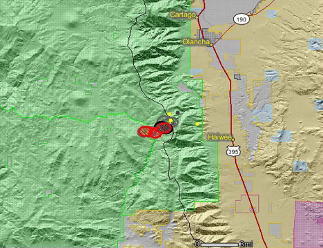
Honeybee WFU Fire
Location: 30 S of Lone Pine, Inyo Co., CA
Specific Location: SW of Haiwee Pass, Inyo National Forest, South Fork of the Kern River
Date of Origin: 05/06/08
Cause: Lightning
Situation as of 05/23/08 PM
Total Personnel: 0
Size: 1,235 acres
Containment: 0%
Costs to Date: $244,000
All personnel have been pulled from the fire. An 8-man fire use module will be detailed tomorrow. The fire will be monitored for future activity. Light snow has damped fire.
***************
Situation as of 05/23/08 AM
Total Personnel: 81 ?
Size: 1,255 acres ?
Containment: not reported
Costs to Date: $181,300 (not updated)
A shroud of silence has descended on the Honeybee Fire. No daily update report has been posted for 2 days. The USFS has plunged this fire into a black hole of secrecy and deceit. All information from this point on must be regarded as untrustworthy and suspect.
***************
Situation as of 05/21/08 PM
Total Personnel: 81
Size: 1,235 acres
Containment: not reported
Costs to Date: $181,300 (not updated)
Crews continue to hold E and S containment lines, cooling the interior with helicopter-delivered water on hot spots. No significant growth today. Red Flag Weather warning still in effect, gusty winds and thunderstorms predicted. Winds N 20 to 30 mph, changing to W 10 to 15 mph tomorrow afternoon.
***************
Situation as of 05/20/08 PM
Total Personnel: 81
Size: 1,235 acres
Containment 0%
Costs to Date: $181,300
Planned Actions: continue holding, cooling the interior and hot spot with bucket when able.
***************
Situation as of 05/20/08 AM
Total Personnel: 74
Size: 1,225 acres (No significant growth 05/19)
Containment 0%
Additional 8-man crew, helicopter, and helicopter support personnel added today. Currently 1 Type 1 line crew, 4 Type 2 line crews, 2 helicopters.
Maximum Manageable Area (MMA) defined in general geographic terms only, but approx. 30,000 acres.
RED FLAG WARNING
The National Weather Service has issued a Red Flag Warning for much of southern Sierra Nevada, Mohave County, Arizona, and portions of southeast California from 1 pm to 9 pm this evening (Tues. 05/20) for gusty winds and low humidities.
A strong area of high pressure will give way to a strong Pacific low pressure system which will reach Northern California this afternoon. Increasing southwest winds will combine with hot and dry weather to produce critical fire weather conditions this afternoon and evening.
Pacific Crest Trail is open.
***************
Situation as of 05/19/08 AM
Total Personnel:57
Size: 1,225 acres
Containment 0%
Cost to date $156,000
Fire progression:
05/06 __ 1 acre
05/12 __ 185
05/13 __ 300
05/15 __ 370
05/16 __ 950
05/17 __ 1085
05/18 __ 1150
05/19 __ 1225
Weather: A strong area of high pressure will hold over the region today and then gradually give way to a strong pacific low pressure system which will reach the Sierras Tuesday afternoon. Increasing southwest winds will combine with hot and dry weather to produce critical fire weather conditions in several zones Tuesday afternoon and evening.
Winds currently SW 10 to 15 mph increasing to 20 to 30 mph in the afternoon.
***************
Situation as of 05/18/08 AM
Total Personnel:57
Size: 1150 acres
Containment 0%
From Cal Fire News [here]: The Sequoia National Forest deployed the Fulton Hotshots and Springville (Type 2 IA crew) into the Kern drainage to keep the fire spread from moving further south. The Inyo has checked fire spread along the crest to prevent fire from running down towards Highway 395.
***************
Situation as of 05/17/08 PM
Total Personnel:57
Size: 1150 acres
Containment 0%
Fire progression:
05/06 __ 1 acre
05/12 __ 185
05/13 __ 300
05/15 __ 370
05/16 __ 950
05/17 __ 1085
05/17 __ 1150
Two 25-man crews were sent out today to fight the Honeybee WFU Fire. The 8-man fire use management team (FUM) was unable to manage or “steer” the fire as high winds caused the fire to expand nearly 4-fold over the last 2 days.
No notice has been issued regarding the Pacific Crest Trail. The Honeybee Fire has crossed Kern River to the West and is creeping along east flank and South Fork of Kern River.
As far as we know the official status of the Honeybee Fire is still WFU although suppression efforts have been applied.
No mention of this incident on InciWeb.
No cost to date information has been released.
***************
Situation as of 05/17/08 AM
Total Personnel: 8
Size: 1085 acres
Containment 0%
Fire progression:
05/06 __ 1 acre
05/12 __ 185
05/13 __ 300
05/15 __ 370
05/16 __ 950
05/17 __ 1085
Is the Honeybee Fire blowing up? No listing on InciWeb. Mostly an info blackout, except for Calfire blog. Large acreage expansions in last two days with strong east winds. Does the USFS really expect to Let It Burn until next Fall?
***************
Situation as of 05/16/08
Total Personnel: 8
Size: 950 acres
Containment 0%
Fire progression:
05/06 __ 1 acre
05/12 __ 185
05/13 __ 300
05/15 __ 370
05/16 __ 950
Fire is putting up black smoke 1500-2000 feet in the air, picking up on the west side flanking with tree torching, east side making small runs. Fire has crossed Kern River to the West and is creeping along east flank and South Fork of Kern River.
***************
Situation as of 05/15/08
Total Personnel: 8
Size: 370 acres
Containment 0%
Fire progression:
05/06 __ 1 acre
05/12 __ 185
05/13 __ 300
05/15 __ 370
Summary: The fire is burning in the area between Haiwee Pass and Olancha Pass, towards the south and west. It has reached the South Fork of the Kern River, and is expected to continue growing, burning onto the Sequoia National Forest.
USFS report: A hand crew, specially trained in wildland fire use, is assigned to the fire and is camping out in the vicinity of the fire, providing on-the-ground observations and monitoring of weather conditions and fire spread predictions. A helicopter is also assigned to the fire and will be used for reconnaissance flights as necessary.
With the north winds, smoke from the Honeybee Fire is traveling down-canyon towards Kennedy Meadows and is expected to have some impact on the area.
Pacific Crest Trail is open?
Note: this map (courtesy Cal Fire News [here]) is from when the fire was 300 acres.
Brevard Fire(s)
Location: Palm Bay, Brevard Co., FL
Date of Origin: 05/11/08
Cause: Arson
Osage Fire (Malabar): 3,708 acres
Madden Fire (Palm Bay): 1,185 acres
Jupiter Fire (Palm Bay): 190 acres
Lowry Fire (Southeast Brevard County): 5,300 acres
Situation as of 05/14/08
Total acreage: 10,300
Personnel: 300
Containment: 40%
An estimated nine fires set. 162 homes reported burned. Suspected arsonist arrested. All Brevard schools will open tomorrow. About 550 Florida Power & Light personnel and contractors are working to restore power. Power should be restored by Friday night.
Breaking news from Orlando Sentinel [here].
Agua Caliente Prescribed Fire
Location: 20 miles E of Tucson, Pima Co. AZ
Specific location: Aqua Caliente Hill (Aqua Caliente Hill to Reddington Road)
Date of Origin: 05/12/08
Cause: prescribed fire
Current Situation
Total Personnel: 80
Size: 11,000 acres (intended at ignition)
Containment: 100% (intended at ignition)
more »
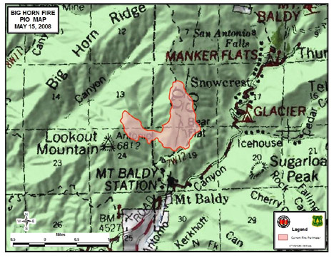
Bighorn Fire
Location: ~10 miles north of Upland, San Bernadino Co./Los Angeles Co., CA
Specific Location: Bear Canyon north of the Mt. Baldy Village area within the Angeles National Forest.
Date of Origin 05/13/2008 at 0430 hrs.
Cause Under Investigation
Situation as of 05/19/08
Total Personnel:
Size: 490 acres
Percent Contained: 100%
Costs to Date: $2,688,708
***************
Situation as of 05/18/08
Total Personnel: 289
Size: 490 acres
Percent Contained: 86%
Increase in fire acreage was due to improved mapping; fire is not growing. Demobilization tomorrow, with additional mop-up of hot spots identified with IR flights tonight.
***************
Situation as of 05/16/08 (eve.)
Total Personnel: 388
Size: 461 acres
Percent Contained: 72%
Estimated Containment Date 05/18/2008 at 1800 hrs.
De-mobilization underway
***************
Situation as of 05/16/08
Total Personnel 755
Size 420 acres
Percent Contained 60%
Estimated Containment Date 05/18/2008 at hrs.
Fire Behavior Fire activity remained minimal and was limited to roll out and short runs back into the black.
InciWeb Remarks: Increase in fire size due in part to fire growth (30%) and better mapping (70%)
W.I.S.E. Fire Tracking Remarks: We were the first and only outlet to report the 340 acre figure 36 hours ago. That was because we dot-gridded the map and calculated our own acreage. We posted 340 when everyone else was saying 300 or 320. We know how to measure maps.
Latest map from Inciweb:
***************
Situation as of 05/15/08
Total Personnel: 668
Size: 340 acres
Percent Contained: 25%
Fuels Involved: Brush with dry grass understory. The area, part of the Angeles National Forest, has not burned since 1975.
Weather outlook: Warm temperatures (near 100 degrees in the valley), very low RH, and strong N-NE winds gusting 30 to 45 mph. This weather pattern could effect the fire’s spread and push it to the southwest. This spread would threaten more homes and establish the fire in more continuous fuels.
Two airtankers and 5+ water-dropping helicopters flew yesterday. Minimal fire behavior was observed through the night. Some crews spiking (camping) near the fire.
***************
Situation as of 05/14/08
Total Personnel: 396
Size: 340 acres
Percent Contained 10%
At 6:00 a.m. today (Wed., May 14), command of the fire was transferred to Southern California Type II IMT (Joseph). Five helicopters were brought in to fight the fire and four are on the scene today. Flame-retardant-dropping planes were unable to fly because of the high winds Tuesday.
Current Wind Conditions: 7 mph S
Current Temperature: 53 degrees
Current Humidity: 33 %
Outlook: Winds N 10 to 15 mph. Gusts up to 30 mph.
***************
Situation as of 05/13/08
Total Personnel: 250
Size: 300 acres
Containment: 0%
Summary: Approximately 6 recreation residences in the vicinity of Bear Canyon have been evacuated. Fire came within about 100 yards of 30 to 40 cabins that were mostly unoccupied, fire officials said. None had been damaged by late afternoon. Mt. Baldy Road at Shinn is closed to the public and open to residents only. Glendora Ridge Road is closed at Mt. Baldy Road and is closed at the east fork. Winds up to 60 mph pushed flames this afternoon. State, federal, and county fire fighting resources resources are responding.
Map courtesy InciWeb, updated 05/13/08
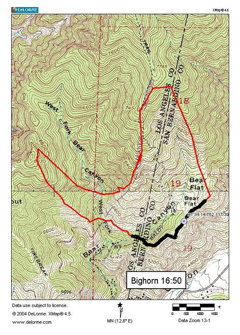
Photo courtesy Luis Sinco / Los Angeles Times

Ralston2 Fire
Location: 20 miles NE of Georgetown, Placer Co. CA
Specific Location: Pennsylvania Point, Georgetown RD, Eldorado NF
Date of Origin: 05/13/2008 at 1651 hrs.
Cause Under: Investigation
Current Situation
Total Personnel: 100
Size: 50 acres
Percent Contained: 20%
Estimated Containment Date 05/14/2008 at 1800 hrs.
Summary: The fire started on private land and burned onto National Forest lands. As of 3:30 PM the fire was estimated to be 50 acres in size. State, federal, and private fire fighting resources resources are responding.
Ferguson Fire
Location: 32 miles northwest of Pueblo, Fremont Co., CO
Specific Location: 15 miles west of Canon City, near the Iron Mountain Fire (2002).
Date of Origin: 05/12/03
Cause: Human, under investigation
Situation as of 05/14/08
Total personnel: 110
Size: 200 acres
Percent Contained: 10%
***************
Situation as of 05/13/08
Total personnel: ???
Size: 200 acres
Percent Contained: 0%
The agencies working the fire are the Deer Mountain Fire Protection District and the Fremont County Sheriff’s Office.
Some families were asked to evacuate. Active fire behavior was reported. Residences and outbuildings are threatened.
Eagle Fire
Location: Apache-Sitgreaves National Forest, south of Alpine, Gila Co., AZ
Specific Location: East Eagle Creek, Clifton RD
Date of Origin: 04/22/2008 at 180 hrs.
Cause: Human — ember From Citty Prescription fire set by USFS
Current Situation: 100% contained 5/1/08
Former situation
Total Personnel: 70
Size: 3,800 acres
Percent Contained: 100%
Fuels: ponderosa pine, pinyon pine, juniper
Summary: The Eagle Fire is on the Clifton Ranger District of the Apache-Sitgreaves National Forests. It was a prescribed fire started on Thursday, April 17,2008 but burned over containment lines into the East Eagle Creek drainage west of Highway 191.
22 WFU Fire
Location: 12 miles southeast of Tusayan, Kaibab NF, Coconino Co. AZ
Date of Origin: 05/06/2008 at 1430 hrs.
Cause: Lightning
Situation as of 05/22/08
Total Personnel: 5
Size: 1,255 acres
Percent Contained: 100% ???
Kaibab NF no longer reporting on the 22 WFU Fire, although it is still burning and growing. Last known report indicated torching and spotting in ponderosa pine with short duration crown fire runs. Last reported acreage may represent some desired or projected size, not actual fire size.
RED FLAG WARNING: Unseasonably strong low pressure system over the Great Basin and northern Arizona will result in yet another very windy day across all of southeast Arizona today (05/22/08). The combination of the strong winds, low humidities, and a very high to extreme fire danger rating has prompted the issuance of a red flag warning.
Winds west 15 to 25 mph with gusts to 40 mph in the evening decreasing to 10 to 20 mph overnight.
***************
Situation as of 05/20/08
Total Personnel: 5
Size: 1,010 acres
Percent Contained: 65%
The 22 Fire has now exceed pre-planned size and has expanded beyond the pre-planned boundaries.
***************
Situation as of 05/19/08
Size 964 acres
Percent Contained 65%
Fire is moving again after smoldering in rains last week.
****************
Situation as of 05/14/08
Total Personnel: 5
Size: 900 acres
Percent Contained: 65%
InciWeb quote: Fire managers are pleased with the results of this wildland fire use event and the resource objectives that were met. The resource benefits to this area include hazardous fuels reduction, cultural resources and wildlife habitat protection and forest health improvement. Fire managers will continue to monitor the fire area.
Interpretation: The 22 WFU Fire did not blow up and destroy tens of thousands of acres of cultural resources and wildlife habitat as did the Kaibab’s Warm WFU Fire in 2006.
***************
Situation as of 05/13/08
Total Personnel: 45
Size: 812 acres
Percent Contained: 60%
The Kaibab NF has announced that the desired management area for this event is 1200 acres. No NEPA documents, such as Environmental Analysis or Environmental Impact Statements have been prepared for the “treatment.” No public involvement process was been implemented prior to this Federal action.
However, should the 22 WFU Fire get out of control, or do damage to resources, then a full NEPA process will be required prior to any rehabilitation efforts or actions.
No announcement has been made regarding the cost of this unprepared burning of public forests, nor of the damage to resources that has occurred.
Fire progression:
05/07 __ 25 acres
05/08 __ 133
05/11 __ 650
05/12 __ 812
05/14 __ 900
National Fire Weather report: Yesterday’s Red Flag Warning has been lifted. A strong cold front will continue to move across Arizona today bringing areas of rain and snow along with isolated thunderstorms, much higher afternoon minimum relative humidities, and much cooler temperatures. Locally accumulating snowfall will occur above 6500 feet over portions of northern and central Arizona. After a drier day on Wednesday scattered showers may return to portions of eastern and central Arizona for Thursday and Friday.
***************
Situation as of 05/12/08
Total Personnel: 45
Size: 650 acres
Percent Contained: 52%
Fuels Involved Grass, ponderosa pine, pinon juniper
Summary: The “22″ Wildland Fire Use fire is currently burning in a fairly open ponderosa pine stand interspersed with meadows. Roads and previously burned areas to the north, northeast and east will limit potential for significant growth. The fire is moving gradually to the southwest as local fire managers predicted. The “22″ Fire will continue to be managed as long as resource objectives are met.
Fire Behavior Primarily surface fire with 1-2 foot flame lengths, isolated interior tree torching.
Weather: Red Flag Weather Warning for strong winds
Current Wind Conditions: 8 mph SW
Current Temperature: 70 degrees
Current Humidity: 10 %
Remarks: Local public interest is high and being addressed by Fire Information Officer. So far, no significant smoke impacts to communities.
Statement released by Kaibab NF: WILLIAMS, Ariz. - Thunderstorms passed over the Kaibab National Forest on Tuesday afternoon igniting several fires on the Kaibab National Forest between Williams and Tusayan. Suppression actions are being taken on all of the new fires except the “22″ Wildland Fire Use fire on the Tusayan Ranger District. The “22″ Fire is about 25 acres, 10 miles southeast of the Tusayan community and is being managed for resource benefits. All of the other new starts have been contained at less than an acre.
The resource benefits from the “22″ Wildland Fire Use fire include: reducing hazardous fuels, protecting and improving wildlife habitat, protecting archaeological sites and restoring fire in its natural role in the ecosystem. This area has benefited from numerous prescribed fire projects over the past 5 years. These treated areas will act as natural barriers to rapid fire spread and will assist fire managers in keeping the fire within a pre-determined area. Actions have been taken to secure the north and the east sides of the “22″ Wildland Fire Use fire to allow it to back slowly into the wind toward the southwest.
Each natural ignition in a fire use management area must meet specific conditions before it can be managed for resource benefits. Some of the criteria include: whether threats to life, property or resources can be alleviated, if sufficient resources are available to manage an incident over the long-term and whether the potential risks outweigh the benefits of a specific wildland fire use incident. If the risks outweigh the benefits, the fire will be suppressed.
Once the decision is made that a fire will be put into wildland fire use status, fire managers actively manage the fire by determining the appropriate boundaries, weather conditions, fuels conditions, etc., under which the fire will be allowed to burn. The “22″ Wildland Fire Use Fire will be managed as a natural part of the ecosystem in a defined area as long as it continues to meet resource objectives.
Solano Fire
Location: 20 miles east of Sells, Pima Co., AZ
Specific Location: Tohono O’odham Nation, Arizona State Trust Land, and BLM Baboquivari Wilderness Area north of Baboquivari Peak.
Date of Origin: 05/09/2008 at 0639 hrs.
Cause: Human
Situation 05/15/08
Total Personnel 68
Size 2,545 acres
Percent Contained 95%
Estimated Containment Date 05/15/2008 at hrs.
Management responsibility for the Solano Fire passed to the Tohono O’odham Nation at 1800 on 5-14-08.
Planned Actions: patrol and mop-up
***************
Situation as of 05/14/08
Total Personnel 196
Size 2,177 acres
Percent Contained 90%
Estimated Containment Date 05/15/2008 at hrs.
Demobilization continues this morning, 5-14. The incident will be handed over to local agencies on 5-15.
***************
Situation as of 05/13/08
Total Personnel: 278
Size: 2,177 acres
Percent Contained: 85%
Significant Events: Completion of all line surrounding fire. Demobilization began this morning at 0800.
***************
Situation as of 05/12/08
Total Personnel: 293
Size: 2,177 acres
Percent Contained: 40%
Estimated Containment Date: 05/15/2008 at hrs.
Costs to date: $563,000
Fuels: desert brush, juniper
Arizona State Type 2 IMT (Raley) are fighting the fire. Four miles of fireline remain to be built. No structures are threatened at this time. No injuries have been reported.
Red Flag Weather Warning: winds 15 to 25 mph with gusts to 40 mph today.
