Flash Floods on the Zaca Burn
The following collection of items extracted from the Web tell a story all by themselves.
ZACA FIRE UPDATE [here]
USDA Forest Service - Los Padres National Forest, Last Modified: 10/04/07
“The Zaca Fire burned in very steep and rugged terrain, and while there are islands of unburned vegetation, there are vast areas that are a moonscape now,” Forest Supervisor Peggy Hernandez explained. “With the vegetation gone, there is nothing to hold the soil in place, so the land is very unstable. Dry landslides, rockslides and other erosion is occuring on a daily basis. We expect mudslides and flash flooding when the rains come. Out of concern for public safety, and to allow the watersheds to begin to heal, I will keep the burned area closed to public entry at least through spring 2008,” she added.
“The burned or otherwise disturbed soils are very vulnerable, especially to wheeled vehicles, until vegetation gets reestablished,” said Hernandez. “We know people are anxious to get back into their national forest, but we are asking for their patience and cooperation.”
Preliminary surveys of the burned area show that many hiking trails have been severely damaged by the fire and are completely impassable. “Our volunteers are very anxious to get in there and help reestablish the trails. Unfortunately, it may be some time before the ground is stable enough to allow them to be rebuilt,” said Santa Barbara District Ranger Cindy Chojnacky.
The Zaca Fire started on July 4, and burned approximately 240,207 acres before it was contained on September 2. It is the second largest fire in California’s recorded history and the largest in Santa Barbara County’s recorded history.
……………………………………………………………………………………..
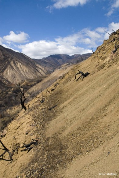
Dry ravel erosion has obliterated the Santa Cruz Trail near the San Rafael Wilderness boundary.
Photo Credit: Lori Rafferty
Courtesy the USDA Forest Service
……………………………………………………………………………………..
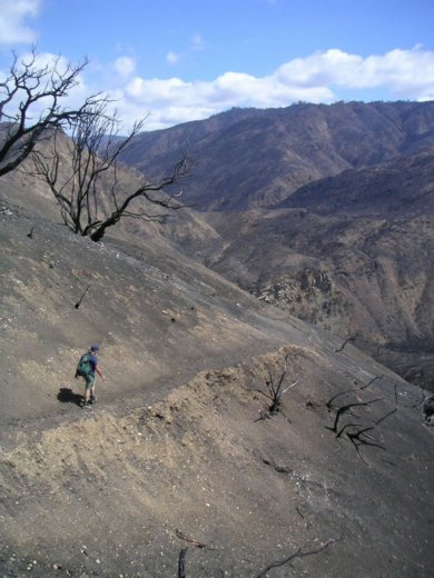
Wilderness Trails Manager Kerry Kellogg inspecting dry ravel erosion on the Santa Cruz Trail just north of the San Rafael Wilderness boundary.
Photo Credit: Bryan Conant
Courtesy the USDA Forest Service
Zaca Fire Impacts Will Linger for Years [here]
By Ray Ford, Independent News, October 18, 2007
It’s been less than two months since flames raced through the Santa Barbara backcountry, burning more than 240,000 acres in a fire that took nearly two months and more than $120 million to put out. For a blaze that turned out to be historic in proportions-it was the county’s largest and the state’s second largest, at least in recorded history-it is remarkable how quickly the Zaca Fire has faded from our consciousness. But while the fire’s smoke plumes and emergency alerts may be forgotten, its aftereffects will be with us for years.
It’s hard to get a handle on a fire that chews up 375 square miles of the rugged and remote Los Padres National Forest. Part of this is because so much of the burned area is way out of sight. There wasn’t much you could see when the wildfire was attacking its 100-mile perimeter and there’s even less now, save for a small section close to Highway 33. So despite the terror it repeatedly sparked in foothill residents and the nightly headlines it made, the Zaca Fire remained largely invisible-and its true impacts will continue to be unknown for quite a while.
The county’s water resources chief Tom Fayram has called the post-Zaca situation a sleeping giant: It may be quiet out in those hundreds of acres of watershed right now, but when the first big winter storms come ashore, we may be in for an extremely rude awakening…
Flash Flood Watch [here]
Statement as of 3:30 PM PST on January 24, 2008
The National Weather Service in Oxnard has issued an
* urban and small stream flood advisory for… central Santa Barbara County southern Ventura County in southwest California… this includes the cities of Santa Barbara… Thousand Oaks… and Ventura…
* until 630 PM PST
* at 325 PM PST National Weather Service Doppler radar indicates moderate to locally heavy rain showers with isolated thunderstorms across Santa Barbara and southern Ventura counties. This activity will produce rainfall rates of up to 0.50 inches per hour as it moves quickly to the east at 35 mph. Total rain amounts of one-half to one inch will occur through 6 PM PST with activity turning to scattered showers by early evening.
Excessive runoff from heavy rainfall will cause elevated levels on small creeks and streams… and ponding of water in urban areas… highways… streets and underpasses as well as other poor drainage areas and low lying spots.
A flood advisory means river or stream flows are elevated or ponding of water in urban or other areas is occurring or is imminent…
* Through Friday afternoon
* periods of rain… heavy at times… with isolated thunderstorms will continue through late Friday afternoon. Rainfall rates of one half inch to one inch per hour are possible across the area any time through late Friday afternoon. This could lead to significant flash flooding and the possibility of debris flows in and around the recent burn areas.
A Flash Flood Watch means that conditions may develop that lead to flash flooding. Flash flooding is a very dangerous situation.
Persons living in or below the watch area should remain alert and follow directions of emergency preparedness officials. Evacuations should begin immediately without waiting for instructions if heavy flows of water or mud and debris are observed. You should monitor later forecasts and be prepared to take action should flash flood warnings be issued.