Harden Fire
Location: 13 miles N of Yosemite Valley, Mariposa Co., CA
Specific Location: W of Harden Lake and within the 1996 Ackerson Fire perimeter, Hetch Hetchy watershed, Lat 37° 53´ 37″, Lon 119° 42´ 13″
Date of Origin: 06/08/2009
Cause: Lightning
Situation as of 07/06/2009 6:30 pm
Personnel: 68
Size: 1,661 acres
Percent Contained: 95%
Demobed 2 Type 1 crews. Transitioned to a Type IV organization.
***************
Situation as of 07/06/2009 6:00 pm
Personnel: 137
Size: 1,661 acres
Percent Contained: 90%
Costs to Date: $679,000
Smith Meadows and Harden Lake trails remain closed.
Perimeter is 90% blacklined within containment lines. Holding and continue burnout of unburned fuels along containment line. 2 crews, 1 engine and 2 Information Officers demob tomorrow.
***************
Situation as of 07/05/2009 12:00 pm
Personnel: 136
Size: 1,594 acres
Percent Contained: 75%
***************
Situation as of 07/04/2009 3:00 pm
Personnel: 141
Size: 1,120 acres
Percent Contained: 30%
Costs to Date: $589,700
***************
Situation as of 07/03/2009 2:00 pm
Personnel: 141
Size: 931 acres
Percent Contained: 25%
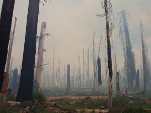
Photo courtesy Inciweb [here]. The snags in the photo were green old-growth trees killed by the 1996 Ackerson Fire (47,000 acres, the largest fire in Park history). The Harden Fire is a repeat fire 13 years later.
***************
Shotgun Foofurb Fire
Location: Golden Trout Wilderness, Sequoia NF, Kern Co. CA
Specific Location: N of Glacier Pt. Road, Lat 36° 20´ 11″, Lon 118° 32´ 8″
Date of Origin: 05/30/2009
Cause: Lightning
Situation as of 07/09/2009 6:30 am
Personnel: 90
Size: 900 acres
Percent Contained: not reported
Costs to Date: $354,000
***************
Situation as of 07/07/2009 7:30 am
Personnel: 90
Size: 899 acres
Percent Contained: 30%
Costs to Date: $280,000
***************
Situation as of 07/06/2009 7:30 am
Personnel: 89
Size: 615 acres
Percent Contained: 0%
Costs to Date: $280,000
***************
Situation as of 07/05/2009 7:15 am
Personnel: 89
Size: 615 acres
Percent Contained: 0%
Costs to Date: $240,000
***************
Situation as of 07/04/2009 8:00 pm
Personnel: 89
Size: 478 acres
Percent Contained: 5%
***************
Situation as of 07/03/2009 6:30 am
Personnel: 89
Size: 412 acres
Percent Contained: 5%
***************
Grouse Fire
Location: 3 miles S of Yosemite Valley, Mariposa Co., CA
Specific Location: N of Glacier Pt. Road, Lat 37° 41´ 27″, Lon 119° 41´ 1″
Date of Origin: 05/30/2009
Cause: Lightning
Situation as of 07/11/2009 5:00 pm
Personnel: 149
Size: 3,047 acres
Percent Contained: 98%
Costs to Date: $2,968,000
Incident Command transitioned from Type 3 IMT to ICT4 Kelly Singer, ICT4 (T) Curtis Richmond. This will be the last report unless significant fire activity occurs.
As predicted, the final fire size is ~3,000 acres. Suppression costs are ~$1,000 per acre burned.
***************
Situation as of 07/09/2009 8:00 am
Personnel: 232
Size: 3,039 acres
Percent Contained: 95%
Costs to Date: $2,601,330
***************
Situation as of 07/07/2009 6:30 pm
Personnel: 227
Size: 3,007 acres
Percent Contained: 90%
Costs to Date: $1,702,000
***************
Situation as of 07/05/2009 5:30 pm
Personnel: 358
Size: 2,592 acres
Percent Contained: 85%
Costs to Date: $1,702,000
Division Y is almost tied in from Glacier Point Road to Wawona Road. Continue burnout along Division Y containment line, burn out interior south of Grouse Creek, holding.
***************
Situation as of 07/04/2009 5:30 pm
Personnel: 358
Size: 2,300 acres
Percent Contained: 50%
Costs to Date: $1,480,000
The planned fire size is approximately 3,000 acres.
***************
Situation as of 07/04/2009 1:00 pm
Personnel: 348
Size: 2,160 acres
Percent Contained: 20%
***************
Situation as of 07/03/2009 8:00 pm
Personnel: 335
Size: 1,500 acres
Percent Contained: 17%
***************
Melendrez Pass Fire
Location: 10 miles east of Green Valley, Pima Co. AZ
Specific Location: Nogales RD, Coronado NF Lat 31° 46´ 15″ Lon 110° 49´ 20″
Date of Origin: 05/29/2009
Cause: Lightning
Situation as of 06/02/2009 7:10 pm
Personnel: 194
Size: 5,800 acres
Percent Contained: 70%
Closure of Box Canyon Rd. Completed majority of aerial ignition plan. Denergized back-up powerline for Fort Huachuca.
Continued closure of Box Canyon road. Tied-in burning operations. Patrol and mop-up as needed. Re-energize powerline.
***************
Situation as of 06/01/2009 7:30 pm
Personnel: 210
Size: 5,004 acres
Percent Contained: 50%
Closure of Box Canyon Rd. Completed majority of aerial ignition plan. Denergized back-up powerline for Fort Huachuca.
Recent Lightning Activity Sparks Fires on the Shasta-Trinity National Forest
US Forest Service News Release [here]
REDDING , Calif. (May 29, 2009) – Severe thunderstorm activity on Thursday produced over 900 lightning strikes in Northern California resulting in four small fires on the Shasta-Trinity National Forest. As the lightning-caused fires were discovered, Forest Service firefighters immediately responded and began fire suppression activity.
The Corral Fire, located about ten miles west of Hayfork, in the vicinity of the Indian Valley Guard Station, was discovered around 4 p.m. Thursday. The fire is controlled and was successfully contained to ¼ of an acre in size.
The Wilson Fire, located about six miles west of Platina, was called in at 7:21 p.m. Thursday. It was successfully contained at ¼ of an acre. Firefighters are on scene and will continue to work on fully controlling the fire.
The Donaldson Fire, located about four miles NE of Hayfork, is contained at 1/2 acre in size. Firefighters predict full control of this fire Friday evening.
Firefighters are also on scene at a fire discovered earlier today. The West Fire, a small fire located just north of the Yolla Bolla-Middle Eel Wilderness, was successfully controlled Friday evening.
Fire lookout facilities are staffed and aerial reconnaissance is on-going during this period of high fire potential.
Forest Service meteorologists expect continued lightning activity for the next four to seven days with an accompanying increased chance of precipitation.
Updates will be provided as new information becomes available.
General fire information can be found at: http://www.fs.fed.us/r5/shastatrinity
Green Grass Fire
Location: 9 mi East of Kent, Sherman Co. OR
Specific Location: 1 mi S of the John Day River, Lat 45° 11´ 14″, Lon 120° 31´ 17″
Date of Origin: 05/30/2009
Cause: Lightning
Situation as of 05/31/2009 1:30 pm
Personnel: 61
Size: ~2,000 acres
Percent Contained: 0%
Prineville IHC committed to fire, as well as H2JG helicopter.
