Marteen WFU Fire
Marteen WFU Fire
Location: 15 miles northeast of Williams, Coconino Co., AZ
Specific Location: Kaibab NF, 35.443 latitude, -112.023 longitude
Date of Origin: 08/07/2008
Cause: lightning
Situation as of 10/31/2008 1:00 PM
Personnel: 28
Size: 9,947 acres
Percent Containment: 0%
Very active fire behavior with spotting and torching. Fire reached and burned approximately 40-50 acres on the W side on Laws Hill. Fireline was reinforced along Forest Road 118 to Horse Lake. Worked on a 20 acre spot north of Red Hill.
Increased winds, up to 20 mph, are predicted this week.
***************
Situation as of 10/29/2008 11:00 PM
Personnel: 19
Size: 7,181 acres
Percent Containment: 0%
Fuels Involved: Ponderosa pine, grass, brush and pinyon juniper
Fire Behavior: Active ground fire, short runs with isolated torching.
Aerial and hand ignitions used to reinforce buffer zone between fire and private property.
***************
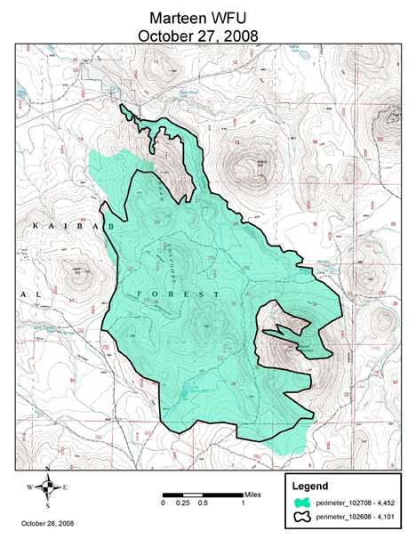
Situation as of 10/27/2008
Personnel: 13
Size: 4,452 acres
Percent Containment: 0%
Fire spreading at a steady pace along the Coxcomb Ridge System. Fire personnel on the Kaibab National Forest continue to manage the Marteen Wildland Fire Use for resource benefits. Tuesday, 10/28, personnel will take actions to reinforce a fireline southeast of the fire along the boundary between the Kaibab National Forest and private property.
***************
Situation as of 10/24/2008
Personnel: unknown
Size: 2,982 acres
Percent Containment: 0%
Currently, actions are taking place to create a buffer between the leading edge of the fire and private property in Spring Valley, north of I-40. Other actions taken on the incident to date include protecting archaeological sites, preventing rapid-fire spread upslope on Squaw Mountain and pre-emptive burning around private property to the north in advance of fire spread.
***************
Situation as of 10/21/2008
Personnel: unknown
Size: 1,135 acres
Percent Containment: 0%
The fire started August 7 by lightning and grew to 700 acres before stalling out under steady monsoonal wet weather. On Oct. 15, fire personnel observed renewed activity. Personnel assigned to the incident are monitoring activity and recording fire progression.
***************
Situation as of 8/23/2008
Personnel: 8
Size: 469 acres
Percent Containment: 0%
Today, personnel will implement management actions to prevent fire spread toward private property. Friday, personnel took measures to protect archaeological sites. Managers are also developing a comprehensive strategy that outlines management actions that will be implemented throughout the duration of the incident.
***************
Situation as of 8/22/2008
Personnel: unknown
Size: 389 acres
Percent Containment: 0%
Fire activity has increased on the Marteen Wildland Fire Use and the Newt Wildland Fire Use incidents on the Kaibab National Forest. Over the past week, a dry and warm weather pattern has contributed to increased fire behavior on both fires.
This year, the Kaibab National Forest is one of 30 sites participating in a pilot program testing proposed changes to the Federal Wildland Fire Management Policy. These modifications will allow fire managers a full range of management options on naturally ignited fires on federal lands.
Juliet Fire
Location: SE portion of Camp Pendleton Marine Base, 2 mi N of Oceanside, San Diego Co, CA
Specific Location: Lat 33° 18´ 39″ Lon 117° 17´ 46″
Date of Origin: 10/13/2008
Cause: under investigation
Situation as of 10/15/2008 at 7:00 PM
Personnel: 148
Size: 4,026 acres
Percent Containment: 90%
Costs to Date: $1,650,000
Structures Destroyed: NONE
Some residential areas on Camp Pendelton remain evacuated due to damaged infrastructure.
Expectation is to transition incident back to Camp Pendelton Fire and Emergency Services at 0700 on 10/16/08. Small increase in acreage is due to more accurate mapping with GIS staff. Isolated interior hot spots remain to be mopped up.
***************
Situation as of 10/14/2008 at 7:00 PM
Personnel: 719 (not updated)
Size: 3,980 acres
Percent Containment: 60%
Costs to Date: $700,000
Some residential areas on Camp Pendleton remain evacuated due to fire hazard and damaged infrastructure. All of the off-base evacuations have been lifted and all roads within Oceanside and Fallbrook will be opened to unrestricted traffic at 2200.
Smoldering surface fire in heavier fuels. Incident resources assisted with an IA fire in the Las Pulgas area that closed I-5 for an hour today.
***************
Situation as of 10/14/2008 at 7:00 AM
Personnel: 351 (not updated)
Size: 3,650 acres
Percent Containment: 25%
Google Earth fire map from 7:00 AM today shows active fire in N. Camp Pendleton and less than a half mile from residential areas of Fallbrook, Hellers Bend, and Bonsall (adjacent to Sleeping Indian Road).
***************
Situation as of 10/13/2008 at 10:00 PM
Personnel: 351
Size: 1,500 acres
Percent Containment: 0%
Evacuations on Camp Pendleton and in residential housing tracts SE of the Base in Oceanside. Federal Type 2 team is svheduled to assume management of the fire at 6:00 AM Tuesday. No mention of possible threat to San Onofre State Park and nuclear generating station.
***************
Situation as of 10/13/2008 at 6:00 PM
Personnel:
Size: 500 acres
Percent Containment: 5%
Sesnon Fire
Location: San Fernando Valley, E of Simi Valley, Los Angeles Co., CA
Specific Location: Browns Canyon, Porter Ranch, Aliso Canyon, Mormon Canyon, Hialeah Springs, Lat 34° 18´ 35″ Lon 118° 36´ 32″
Date of Origin: 10/13/2008
Cause: under investigation
Situation as of 10/17/2008 at 7:00 PM
Personnel: 1,377
Size: 14,703 acres
Percent Containment: 100%
Costs to Date: $12,062,314
Structures Destroyed: 15 residences, 63 outbuildings
Demob efforts continue to progress quickly and smoothly. Transition to jurisdictional agencies is planned to occur on 10/19 at 0700.
***************
Situation as of 10/15/2008 at 7:00 PM
Personnel: 2,847
Size: 13,825 acres
Percent Containment: 50%
Costs to Date: $6,100,000
Structures Destroyed: 15 residences (revised), 47 outbuildings
Previously evacuated citizens are being allowed to return in selected areas. Reduction in number of structures “destroyed” is a result of more comprehensive assessment by damage assessment personnel.
Continue direct line construction. Due to the favorable change in wind and weather, decreasing fire behavior, and significant success in containment operations, significant demob of resources is expected to begin tomorrow.
Moderate to high intensity fire behavior was observed with isolated wind and slope driven runs on the southwest and northwest flanks of the fire.
***************
Situation as of 10/14/2008 at 7:00 PM
Personnel: 2,338
Size: 13,285 acres
Percent Containment: 20%
Costs to Date: $2,500,000
Structures Destroyed: 19 residences , 47 outbuildings
Fire extends from Las Llajas Canyon near Simi Valley to Bee Canyon near San Fernando. Fire is still W of Balboa Blvd.
***************
Situation as of 10/14/2008 at 7:00 AM
Personnel: 789 (not updated)
Size: 10,000 acres
Percent Containment: 0%
Google Earth fire map from 7:00 AM today shows active fire from Northridge to Bee Canyon S of Sesnon Blvd.
***************
Situation as of 10/13/2008 at 10:00 PM
Personnel: 789
Size: 7,000 acres
Percent Containment: 0%
Fire behavior has been extremely erratic due to Santa Ana winds. Long range spotting has been observed.
***************
Situation as of 10/13/2008 at 6:00 PM
Personnel:
Size: 6,000+ acres
Percent Containment: 0%
Evacuations: Twin Lakes, Indian Hills, Porter Ranch, Renaissance community, Hialeah Springs, Box Canyon, Bell Canyon, Woolsey Canyon, Lake Manor, Dayton Canyon, Browns Canyon, Twin Lakes area, W of Valley Circle.
Evacuation Centers: Shepherd of the Hills in Porter Ranch, Ventura County Fairgrounds (for livestock only).
Fire jumped Hwy 118 in the Porter Ranch area. Hwy is closed at Reseda. Fatal traffic accident w/vehicle fire on the 118 freeway near Porter Ranch evacuations.
Winds gusts are 60 to 70 mph. Unconfirmed reports of the Aliso oil field on fire. Fire has come S out of the hills and is burning in residential areas near Chatsworth at the N end of Topanga Canyon Blvd, S of the Reagan Freeway (Hwy 118).
Driven by Santa Ana winds, the fire has spread W from Mission Peak to the hills W of Rocky Peak just E of Simi Valley.
Marek Fire
Location: 3 mi E of San Fernando, Los Angeles Co., CA
Specific Location: Little Tujunga Canyon, Kagel Canyon, Lake View Terrace, Lat 34° 17´ 41″ Lon 118° 21´ 40″
Date of Origin: 10/12/2008
Cause: human
Situation as of 10/17/2008 at 6:00 AM
Personnel: 262
Size: 4,824 acres
Percent contained: 100%
Costs to Date: $6,097,386
Structures Destroyed: 41 residences , 22 outbuildings, 2 commercial buildings
The fire will be turned back to the forest and a type 3 organization at 0600 today.
***************
Situation as of 10/15/2008 at 6:00 PM
Personnel: 499
Size: 4,824 acres
Percent contained: 92%
Costs to Date: $4,059,455
Structures Destroyed: 41 residences , 22 outbuildings, 2 commercial buildings
All evacuations have been lifted. Osborne Road south of the 210 Fwy to Foothill Blvd and Pacoima Road to Pacoima Dam remains closed. The evacuation center at San Fernando High School remains open.
The following structures were lost during the fire storm on the morning of October 13th: Skyview Terrace Mobile Home Park, 6 residences damaged and 38 destroyed; Dexter Canyon, 2 residences damaged and 2 destroyed; Lower Lopez Canyon, 1 residence damaged, 1 commercial building damaged and 2 commercial buildings destroyed.
With diminishing winds and successful suppression efforts, fire activity was limited to creeping a smoldering of unburned fuels well within containment lines. Significant demob of resources occurred today. Crews completed line construction on the north perimeter. Major progress was made on mop-up and rehab. Resources continued to patrol and provide structure protection resources.
***************
Situation as of 10/14/2008 at 6:00 PM
Personnel: 1,471
Size: 4,824 acres
Percent contained: 60%
Costs to Date: $3,204,323
Structures Destroyed: 39 residences , 5 outbuildings
Lopez Canyon remains under mandatory evacuation with limited access to some businesses and Kagel Canyon is open to residents only. All other evacuations were lifted today. All freeway and road closures were lifted today with the exception of Osborne Road south of the 210 Fwy and Pacoima Road to Pacoima Dam. The evacuation center at San Fernando High School remains open. The large animal evacuation center located at Pierce College and small animal evacuation center located at the North Mission Shelter remains open.
With diminishing winds and successful suppression efforts, active burning was limited to unburned islands of fuels well within containment lines and the burnout operation on the north perimeter. Demob of excess resources is in progress.
***************
Situation as of 10/14/2008 at 7:00 AM
Personnel: 1,297 (not updated)
Size: 4,824 acres
Percent contained: 70%
Google Earth fire map from 7:00 AM today shows active fire NW of Pacoima Reservoir and on Kagel Mountain.
***************
Situation as of 10/13/2008 at 10:00 PM
Personnel: 1,297
Size: 4,726 acres
Percent contained: 5%
Costs to Date: $1,000,000
Structures Lost: 39 residences, 5 outbuildings. Structures Threatened: 3,000 residences, 600 outbuildings
Mandatory evacuations were established for Lake View Terrace north of the 210 Fwy, Sylmar on the north and east interface, the area east of the Pacoima Wash and the area north of the 210 Fwy from Hillside to the 5 Fwy. Olive View Hospital is under evacuation in place. Mandatory evacuations and road closures will remain in effect for Lopez, Kagel and Tujunga Canyon. Evacuation centers are established at San Fernando High School and Sylmar High School. A large animal evacuation center is established at Pierce College and a small animal evacuation center is established at the North Mission Shelter.
38 mobile homes were destroyed in the Valley View Estates this morning. One single family dwelling and garage was destroyed in the Dexter Park area. The 210 Fwy was closed between the 5 Fwy and Hwy 2. A transient citizen in the Sylmar area was found fatally burned in a makeshift dwelling this morning.
Extreme Santa Ana wind driven fire runs with spotting ahead of the fire front. Progress constructing line and mop-up around structures and along containment lines. Resources conducted burnout operations on the northwest perimeter.
***************
Situation as of 10/13/2008 at 7:00 PM
Personnel: no update
Size: 4,726 acres
Percent contained: 5%
Structures Lost: 35 residences, 5 outbuildings. Structures Threatened: not updated
3,800 residents evacuated from Lopez Canyon to Hubbard St and North of 210 Fwy, Kagel Canyon. Lopez Rd closed to the 210 Fwy. MacClay Health Center and UCLA Olive View Medical Center evacuated most fragile infirm patients and newborns this morning.
Evacuation Center: Sylmar HS, 13050 Borden Ave, Sylmar and San Fernando H.S., 1133 Omelveny St., San Fernando. Livestock Evacuation Center: Hansen Dam equestrian center.
Wind driven fire runs with spotting 1/8 mile ahead of the fire were common. Coordinated air and ground suppression limited fire spread.
***************
Situation as of 10/12/2008 at 7:00 PM
Personnel: 835
Size: 2,212 acres
Percent contained: 25%
Structures Lost: 1 residences, 5 outbuildings. Structures Threatened: 450 residences, 200 outbuildings
Evacuations of Lopez and Kagel Canyons. An evacuation center has been established at San Fernando High School, 1133 O’Melveny, San Fernando, CA. An animal evacuation center has been established at Lake View Terrace and the 210 Fwy. Mandatory evacuations and road closures remain in effect for Lopez, Kagel and Tujunga Canyon.
Wind driven fire runs with spotting 1/8 mile ahead of the fire were common. Coordinated air and ground suppression limited fire spread. Line construction on the west/southwest perimeter. Patrol and mop-up along Little Tujunga Canyon Road. Continue to provide structure protection resources.
***************
Situation as of 10/12/2008 at 1:00 PM
Personnel: 1,000+
Size: 750+ acres
Percent contained: 50%
Structures Lost: 2 residences, 1 outbuilding
Evacuations of Lopez and Kagel Canyons. An evacuation center has been established at San Fernando High School, 1133 O’Melveny, San Fernando, CA.
Fire activity is expected to be extreme with Santa Ana wind conditions predicted.
Sacramento Fire
Location: N of Topock, AZ, 10 mi SE of Needles, CA
Specific Location: N of I-40, both sides Colorado River, Havasu Natl Wildlife Refuge to Moab Regional Park, Lat 34° 43´ 38″ Lon 114° 28´ 39″
Date of origin: 09/29/2008
Cause: human
Situation as of 10/01/2008 at 7:00 PM
Personnel: 119
Size: 328 acres
Percent Contained: 30%
Hwy 66 closed. Structures Threatened: 20 residences , 2 commercial , 12 outbuildings
Firefighter Fatality: from the Havasu Sun News, Thursday, October 2, 2008 [here]
An Arizona Department of Corrections officer collapsed and died of apparent natural causes Wednesday while fighting a wild fire near Topock.
Douglas Falconer was the supervisor of an inmate wild fire hand crew from Globe brought in to fight the so-called Sacramento Fire under the direction of the U.S. Fish and Wildlife Service.
The fire, which started Sunday, has burned at least 328 acres in the Havasu Wildlife Refuge and was 30 percent contained Wednesday, according to a USFWS press release.
According to the Department of Corrections, officers and inmates on the hand crew responded with emergency medical assistance when Falconer collapsed, but they were unable to revive him. …
Timber WFU Fire
Location: 13 miles NE of Spencer, Clark Co., ID
Specific Location: Centennial Mtns., N of Camas Creek, Caribou-Targhee NF, Lat 44° 30´ 6″ Lon 112° 1´ 21″
Date of origin: 09/29/2008
Cause: lightning
Situation as of Oct 03, 2008 2:45 PM
Personnel: 17
Size: 1,747 acres
Percent contained: 0%
MMA: not reported
Single and group tree torching. Short crown runs, 1/4 mile spotting. Fire has burned ~100 acs in Montana, Beaverhead NF.
***************
Situation as of Oct 01, 2008 5:00 PM
Personnel: 8
Size: 600+ acres
Percent contained: 0%
MMA: not reported
Single and group tree torching. Short crown runs, 1/4 mile spotting. Fire has moved N and crossed into Montana, Beaverhead NF.
