The relationship of respiratory and cardiovascular hospital admissions to the southern California wildfires of 2003
R. J. Delfino, S. Brummel, J. Wu, H. Stern, B. Ostro, M. Lipsett, A. Winer, D. H. Street, L. Zhang, T. Tjoa and D. L. Gillen. 2008. The relationship of respiratory and cardiovascular hospital admissions to the southern California wildfires of 2003. Occup. Environ. Med. 2009;66;189-197.
Note: lead author is Dr. Ralph J. Delfino, Epidemiology Department, School of Medicine, University of California, Irvine, CA
Full text [here]
Selected excerpts:
ABSTRACT
Objective: There is limited information on the public health impact of wildfires. The relationship of cardiorespiratory hospital admissions (n=40 856) to wildfirerelated particulate matter (PM2.5) during catastrophic wildfires in southern California in October 2003 was evaluated.
Methods: Zip code level PM2.5 concentrations were estimated using spatial interpolations from measured PM2.5, light extinction, meteorological conditions, and smoke information from MODIS satellite images at 250 m resolution. Generalised estimating equations for Poisson data were used to assess the relationship between daily admissions and PM2.5, adjusted for weather, fungal spores (associated with asthma), weekend, zip code-level population and sociodemographics.
Results: Associations of 2-day average PM2.5 with respiratory admissions were stronger during than before or after the fires. Average increases of 70 mg/m3 PM2.5 during heavy smoke conditions compared with PM2.5 in the pre-wildfire period were associated with 34% increases in asthma admissions. The strongest wildfire-related PM2.5 associations were for people ages 65–99 years (10.1% increase per 10 mg/m3 PM2.5, 95% CI 3.0% to 17.8%) and ages 0–4 years (8.3%, 95% CI 2.2% to 14.9%) followed by ages 20–64 years (4.1%, 95% CI 20.5% to 9.0%). There were no PM2.5–asthma associations in children ages 5–18 years, although their admission rates significantly increased after the fires. Per 10 mg/m3 wildfire-related PM2.5, acute bronchitis admissions across all ages increased by 9.6% (95% CI 1.8% to 17.9%), chronic obstructive pulmonary disease admissions for ages 20–64 years by 6.9% (95% CI 0.9% to 13.1%), and pneumonia admissions for ages 5–18 years by 6.4% (95% CI 21.0% to 14.2%). Acute bronchitis and pneumonia admissions also increased after the fires. There was limited evidence of a small impact of wildfire-related PM2.5 on cardiovascular admissions.
Conclusions: Wildfire-related PM2.5 led to increased respiratory hospital admissions, especially asthma, suggesting that better preventive measures are required to reduce morbidity among vulnerable populations.
We present here the largest study to date evaluating the relationships of hospital admissions for cardiorespiratory outcomes to wildfire-associated PM2.5 using data from the catastrophic wildfires that struck southern California in the autumn of 2003. We linked PM2.5 concentrations estimated at the zip code level to a population-based dataset of hospital admissions using spatial time series analyses of data before, during and after the fires. Strong, dry winds from inland deserts fanned flames from nine distinct fires, which burned nearly three quarters of a million acres and destroyed approximately 5000 residences and outbuildings. The wildfires generated large amounts of dense smoke that covered much of urban southern California (2003 population of 20.5 million). PM2.5 and PM10 concentrations far exceeded US federal regulatory standards. The goal of the present study is to assess the impact of this large wildfire event on serious morbidity.
Rhymes With Chiricahua.
Stephen J. Pyne. 2009. Rhymes With Chiricahua. Copyright 2009 Stephen J. Pyne
Full text [here]
Selected excerpts:
While the Chiricahua Mountains are famous for many reasons to many groups, they are rarely known for their fires. They should be. Some start from lightning, some from ranchers. Some are set by rangers, or are allowed some room to roam by them. Some are left by transients in the person of hunters, campers, and hikers. In recent years more are associated with traffic across the border with Mexico. The Chiricahuas have, at the moment, less of this than other border-hugging districts within the Coronado National Forest, but fires to distract, fires to hide, and fires abandoned by illegal border-crossers are becoming more prominent. All in all, it’s an interesting medley.
Mark Twain once observed that history doesn’t repeat itself but it sometimes rhymes. These days it seems there is a lot of rhyming in the Chiricahuas as fires echo a fabled but assumed vanished past. This revival moves the Chiricahuas, among the most isolated of mountain ranges, a borderland setting for fire as for other matters, close to the core of contemporary thinking about managing fire in public wildlands.
The Chiricahuas –- actually a giant, deeply eroded and flank-gouged massif –- are among the southernmost of America’s Sky Islands, compact mountain ranges that both cluster and stand apart from one another, like an archipelago of volcanic isles. They are famous for their powers of geographic concentration. Their rapid ascent creates in a few thousand vertical feet what, spread horizontally, would require a few thousand miles to replicate. Here, density replaces expansiveness. One can see across a hundred miles of sky, and into half a continent of ecosystems. It is possible to traverse from desert grassland to alpine krumholtz almost instantly.
They are equally renown for their isolation, not only from the land surrounding them but from one another. The peaks array like stepping stones between the Sierra Madre Occidental and the Colorado Plateau; here, North America has pulled apart and the land has fallen between flanking subcontinental plateaus like a collapsed arch, leaving a jumble of basins and ranges as jagged mountains to poke through the rubble. The degree of geographic insularity is striking: they are mountain islands amid seas of desert and semi-arid grasslands. On some peaks relict species survive from the Pleistocene; on others, new subspecies appear. No peak has everything the others do. A Neoarctic biota mixes with a Neotropical one, black bear with jaguar, Steller’s jay with thick-beaked parrot. The Pinaleños have Engleman spruce. Mount Graham boasts a red squirrel. The Pedragosas grow Apache pine. The Peloncillos are messy with overgrowth and dense litter; the Huachucas, breezy with oak savannas. The Madrean Archipelago displays the general with the distinct: unique variations amid a common climate. They can serve as a textbook example of island biogeography. That observation extends to their fires as well. …
The Forest Health Crisis: How Did We Get In This Mess?
Charles E. Kay. 2009. The Forest Health Crisis: How Did We Get In This Mess? Mule Deer Foundation Magazine No.26:14-21.
Dr. Charles E. Kay, Ph.D. Wildlife Ecology, Utah State University, is the author/editor of Wilderness and Political Ecology: Aboriginal Influences and the Original State of Nature [here], author of Are Lightning Fires Unnatural? A Comparison of Aboriginal and Lightning Ignition Rates in the United States [here], co-author of Native American influences on the development of forest ecosystems [here], and numerous other scientific papers.
Full text with photos (click on photos for larger images):
THE WEST is ablaze! Every summer large-scale, high-intensity crown fires tear through our public lands at ever increasing and unheard of rates. Our forests are also under attack by insects and disease. According to the national media and environmental groups, climate change is the villain in the present Forest Health Crisis and increasing temperatures, lack of moisture, and abnormally high winds are to blame. Unfortunately, nothing could be further from the truth.
The Sahara Desert, for instance, is hot, dry, and the wind blows, but the Sahara does not burn. Why? Because there are no fuels. Without fuel there is no fire. Period, end of story, and without thick forests there are no high-intensity crown fires. Might not the real problem then be that we have too many trees and too much fuel in our forests? The Canadians, for instance, have forest problems similar to ours but they do not call it a “Forest Health Crisis,” instead they call it a Forest Ingrowth Problem. The Canadians have correctly identified the issue, while we in the States have not. That is to say, the problem is too many trees and gross mismanagement by land management agencies, as well as outdated views of what is natural.
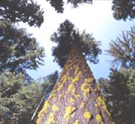
When Europeans first arrived in the West, ponderosa pine forests were open and park-like. You could ride everywhere on horseback or even in a horse and buggy, the forests were so open. On average there were only between 10 and 40 trees per acre with an understory of grasses, forbs, and shrubs. Extensive meadows were also common. In short, ideal mule dear habitat.
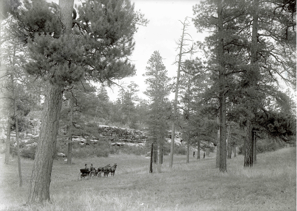
Photo 1 — A 1905 photograph of a ponderosa pine forest on the Kaibab in northern Arizona. It is amazing how parklike our pine forests once were. The forests were so open that you could travel virtually anywhere in a horse and buggy. Understory grasses, forbs, and shrubs were abundant. U.S. Geological Survey photo.
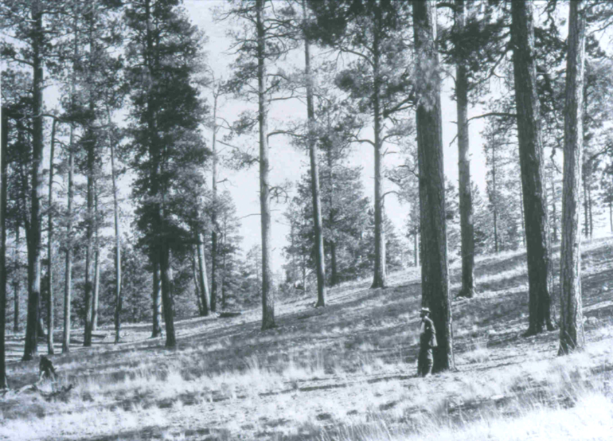
Photo 2 — A 1903 photograph of a ponderosa pine forest on the Coconino in northern Arizona. Note the park-like conditions and the men for scale, as well as the abundance of understory forage. Due to the openness of the forest, historically, crown fires never occurred, unlike conditions today. U.S. Forest Service photo.
Today, however, those same forests contain anywhere from 500 to 2,000 mostly smaller trees per acre. Travel on horseback is out of the question, and access by foot is even difficult. Many former meadows are now overgrown with trees. Understory forage production is approaching zero and our pine forests are becoming increasingly worthless as mule deer habitat.
The Wildland/Science Interface
Stephen J. Pyne. 2009. The Wildland/Science Interface. Copyright 2009 Stephen J. Pyne
Full text [here]
Selected excerpts:
A long narrow road winds steeply up into thickly-wooded backcountry to an exclusive enclave of costly structures, all well beyond the periphery of settlement. It’s the formula for the worstcase scenario of the wildland/urban interface, except that this is no subprime landscape stuffed with trophy homes. It’s a telescope complex atop Mount Graham, and on the Sky Islands of Arizona the scene is repeated four times. Call it the wildland/science interface.
Fire management accepts as axiomatic that it is science-based or at least science-informed and that good science is the antidote to the toxins of politics, land development, and a Smokey-blinkered populace that doesn’t understand the natural ecology and inevitability of fire. Science is better than experience or history, and more science is better still. Science, preferably natural science, since even social science is tainted with the implied values of its human doers, is the solution. At Mount Graham, however, it is the problem. And the challenge is not simply that “science” here underwrites its own version of the WUI and opens paved roads to remote sites that complicate fire management and compromise biodiversity. The real challenge is the assumption that science stands apart from the scene it describes and from its Olympian perch can peer objectively outward and advise wisely.
The Mount Graham International Observatory suggests instead, that science’s lofty perch is not removed from land management and that science, too, has its self-interests that can influence what it sees, does, and says. Science, in brief, is not an ungrounded platform for viewing the universe of fire and recording its observations. It is sited, and that siting determines what it sees, and decisions over such sites make science and its caste of practitioners as motivated by their own values and ambitions as loggers, ranchers, real estate developers, and ATV recreationists. Science has its own dynamic apart from nature, its own presence on the land, and its own politics. The 1.83 meter primary mirror of the VATT telescope, while nominally looking out, is also a reflecting lens that looks back on its viewers.